
New England Interstate Routes
Encyclopedia
New England
New England is a region in the northeastern corner of the United States consisting of the six states of Maine, New Hampshire, Vermont, Massachusetts, Rhode Island, and Connecticut...
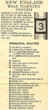
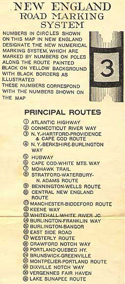
. The routes were marked by a yellow rectangular shield with black numbers and border. Many shields were painted on telephone poles. The routes were approved by the highway departments of the six New England states in April 1922.
Prior to the New England road marking system, through routes were mainly marked with colored bands on telephone poles. These were assigned by direction (red for east-west, blue for north-south and yellow for intermediate or diagonal routes). The Massachusetts Highway Commission convinced the rest of southern New England and New York to use this system in 1915 (New Hampshire and Vermont already had their own schemes, and Maine also opted out), and it was the main system until 1922.
The New England road marking system, while limited to New England, was designed for expansion to the whole country. One- and two-digit numbers were assigned to major interstate routes, with three-digit routes for state routes (marked in a rectangle, with the state abbreviation below the number). In general, odd numbers ran east-west and even numbers ran north-south. The main exception was Route 1, which was to run along the Atlantic coast
Atlantic Coast
The Atlantic Coast is any coast fronting the Atlantic Ocean. The term differentiates the coasts of countries or continents with coastlines on more than one body of water, such as North America, South America, Africa and Europe.-See also:*Indian Ocean...
from Florida
Florida
Florida is a state in the southeastern United States, located on the nation's Atlantic and Gulf coasts. It is bordered to the west by the Gulf of Mexico, to the north by Alabama and Georgia and to the east by the Atlantic Ocean. With a population of 18,801,310 as measured by the 2010 census, it...
to Calais, Maine
Calais, Maine
Calais is a city in Washington County, Maine, United States. The city has three United States border crossings or also known as a Port of entry with the busiest being on the St. Croix River bordering St. Stephen, New Brunswick, Canada...
. A few of the major auto trail
Auto trail
The system of auto trails was an informal network of marked routes that existed in the United States and Canada in the early part of the 20th century. Marked with colored bands on telephone poles, the trails were intended to help travellers in the early days of the automobile.Auto trails were...
s were not to be assigned numbers, instead being marked with letters - for instance, L for the Lincoln Highway
Lincoln Highway
The Lincoln Highway was the first road across the United States of America.Conceived and promoted by entrepreneur Carl G. Fisher, the Lincoln Highway spanned coast-to-coast from Times Square in New York City to Lincoln Park in San Francisco, originally through 13 states: New York, New Jersey,...
and R for the Roosevelt International Highway.
In 1926, several of the routes were supplanted by the national United States Numbered Highways
United States Numbered Highways
The system of United States Numbered Highways is an integrated system of roads and highways in the United States numbered within a nationwide grid...
. Except for Route 1, which became U.S. Route 1
U.S. Route 1
U.S. Route 1 is a major north–south U.S. Highway that serves the East Coast of the United States. It runs 2,377 miles from Fort Kent, Maine at the Canadian border south to Key West, Florida. U.S. 1 generally parallels Interstate 95, though it is significantly farther west between...
, the old numbers were not used, since the U.S. Highway system uses odd numbers for north-south routes and even numbers for east-west routes. While some of the routes that did not become U.S. Routes were disbanded in the 1930s, many of these other routes still have their numbers today, although the unified signage is no longer used.
List of routes
| New England Route | Current routes | Endpoints |
|---|---|---|
 Route 1 Route 1 |
 U.S. Route 1 U.S. Route 1U.S. Route 1 U.S. Route 1 is a major north–south U.S. Highway that serves the East Coast of the United States. It runs 2,377 miles from Fort Kent, Maine at the Canadian border south to Key West, Florida. U.S. 1 generally parallels Interstate 95, though it is significantly farther west between... |
NY/CT state line (NY 1 towards New York City New York City New York is the most populous city in the United States and the center of the New York Metropolitan Area, one of the most populous metropolitan areas in the world. New York exerts a significant impact upon global commerce, finance, media, art, fashion, research, technology, education, and... ) to Calais, Maine Calais, Maine Calais is a city in Washington County, Maine, United States. The city has three United States border crossings or also known as a Port of entry with the busiest being on the St. Croix River bordering St. Stephen, New Brunswick, Canada... (towards Saint John, New Brunswick Saint John, New Brunswick City of Saint John , or commonly Saint John, is the largest city in the province of New Brunswick, and the first incorporated city in Canada. The city is situated along the north shore of the Bay of Fundy at the mouth of the Saint John River. In 2006 the city proper had a population of 74,043... ) |
 Route 1A Route 1A |
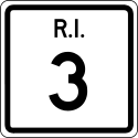 RI Route 3 RI Route 3 |
Westerly, Rhode Island to Providence, Rhode Island Providence, Rhode Island Providence is the capital and most populous city of Rhode Island and was one of the first cities established in the United States. Located in Providence County, it is the third largest city in the New England region... |
 Route 2 Route 2 |
 U.S. Route 5 U.S. Route 5U.S. Route 5 U.S. Route 5 is a north–south United States highway running through the New England states of Connecticut, Massachusetts, and Vermont. Significant cities along the route include New Haven, Connecticut; Hartford, Connecticut; and Springfield, Massachusetts. From Hartford northward to St... |
New Haven, CT (Route 1) to Derby Line, VT (Route 5 towards Sherbrooke, QC) |
 Route 2A Route 2A |
 VT Route 5A VT Route 5A |
West Burke, VT to Derby, VT |
 Route 3 Route 3 |
 U.S. Route 6 U.S. Route 6U.S. Route 6 U.S. Route 6 , also called the Grand Army of the Republic Highway, a name that honors an American Civil War veterans association, is a main route of the U.S. Highway system, running east-northeast from Bishop, California to Provincetown, Massachusetts. Until 1964, it continued south from Bishop to... |
NY/CT state line (towards Bedford, NY Bedford (town), New York Bedford is a town in Westchester County, New York, USA. The population was 17,335 at the 2010 census.The Town of Bedford is located in the northeastern part of Westchester County, and contains the three hamlets of Bedford Hills, Bedford Village, and Katonah... ) to Provincetown, MA |
 Route 4 Route 4 |
 U.S. Route 7 U.S. Route 7U.S. Route 7 U.S. Route 7 is a north–south United States highway in western New England that runs for from Norwalk, Connecticut, to Highgate, Vermont. The highway's southern terminus is at Interstate 95 in Norwalk, Connecticut... |
NY/CT state line (NY 21 towards Amenia, NY) to Highgate Springs, VT (Route 7 towards Montreal, QC) |
 Route 5 Route 5 |
 U.S. Route 20 U.S. Route 20U.S. Route 20 U.S. Route 20 is an east–west United States highway. As the "0" in its route number implies, US 20 is a coast-to-coast route. Spanning , it is the longest road in the United States, and the route sparsely parallels Interstate 90... |
NY/MA state line (NY 5 towards Albany, NY) to Boston, MA (Routes 1 - 6 - 7 - 28) |
 Route 6 Route 6 |
 U.S. Route 3 U.S. Route 3U.S. Route 3 U.S. Route 3 is a north–south United States highway that runs from its southern terminus in Cambridge, Massachusetts through New Hampshire to its terminus near Third Connecticut Lake at the Canadian border, where the road continues north as Quebec Route 257.In New Hampshire parts of US 3 are...  MA Route 3 MA Route 3 |
Orleans, MA (Route 3) to Colebrook, NH (Route 26) |
 Route 6A Route 6A |
 MA Route 3A MA Route 3AMassachusetts Route 3A Route 3A is a state highway in eastern Massachusetts, which parallels Route 3 and U.S. Route 3 from Cedarville in southern Plymouth to Tyngsborough at the New Hampshire state line.... |
Kingston, MA to Quincy, MA |
| Route 6A |
 NH Route 3A NH Route 3ANew Hampshire Route 3A New Hampshire Route 3A is a designation held by two separate state highways in New Hampshire. The two segments, although not directly connected, are linked by U.S. Route 3, from which they derive their route number.-Southern segment:... |
Franklin, NH to Plymouth, NH |
 Route 6B Route 6B |
 MA Route 38 MA Route 38 |
Cambridge, MA to Lowell, MA |
 Route 7 Route 7 |
 MA Route 2 MA Route 2 |
NY/MA state line (NY 7 towards Troy, NY) to Boston, MA (Routes 1 - 5 - 6 - 28) |
 Route 8 Route 8Route 8 (New England) Route 8 is a multi-state north–south state highway in the New England region of the United States, running from Bridgeport, Connecticut, through Massachusetts to Searsburg, Vermont. Its number dates from 1922, when it was a New England Interstate Route, also known as the... |
 CT Route 8 CT Route 8 MA Route 8 MA Route 8 VT Route 8 VT Route 8 |
Stratford, CT (Route 1) to Wilmington, VT (Route 9) |
 Route 9 Route 9Route 9 (New England) Route 9 is a multi-state state highway in the New England region of the United States, running across the southern parts of New Hampshire, Vermont and Maine, and numbered, owned, and maintained by each of those states. Its number was assigned in 1922, when it was designated one of the New England... |
 VT Route 9 VT Route 9 NH Route 9 NH Route 9 State Route 9 State Route 9Maine State Route 9 State Route 9 is a numbered state highway in Maine, running from the New Hampshire border at Berwick in the west to the Canadian border with New Brunswick at Calais in the east. State Route 9 runs a total of .-Route description:... |
NY/VT state line (NY 9 towards Troy, NY) to Wells, ME (Route 1) |
 Route 10 Route 10Route 10 (New England) New England Route 10 was a multi-state north–south state highway in the New England region of the United States, running through Connecticut, Massachusetts, and New Hampshire. "Route 10" still exists as a continuous state highway in each of its original states, running from New Haven,... |
 CT Route 9 CT Route 9 CT Route 10 CT Route 10Connecticut Route 10 Connecticut Route 10 is a state highway that runs between New Haven and the state line near Granby.-Route description:Route 10 begins at Interstate 95 as Ella T. Grasso Boulevard in the city of New Haven. It then passes by Southern Connecticut State University before entering the town of Hamden...  MA Route 10 MA Route 10Massachusetts Route 10 Massachusetts Route 10 is a north–south state highway that runs from the state line at Southwick to the state line at Northfield.-Route description:Route 10 crosses the border from Granby, Connecticut into Southwick, Massachusetts, overlapped with US 202...  NH Route 10 NH Route 10New Hampshire Route 10 New Hampshire Route 10 is a north–south state highway in the U.S. state of New Hampshire. Its southern terminus is at the Massachusetts state line in the town of Winchester. In Massachusetts the highway becomes Massachusetts Route 10. Total length of the highway is .-Route description:NH 10... |
Old Saybrook, CT (Route 1) to Littleton, NH (Route 18) |
 Route 11 Route 11Route 11 (New England) New England Interstate Route 11 , also known as the Manchester-Biddeford Route, was a New England Interstate Route running from Manchester, Vermont to Biddeford, Maine via Franklin, New Hampshire... |
 VT Route 11 VT Route 11 NH Route 11 NH Route 11 State Route 11 State Route 11 State Route 111 State Route 111 |
Manchester, VT (Route 4) to Biddeford, ME (Route 1) |
 Route 12 Route 12Route 12 (New England) New England Route 12 was a multi-state north–south state highway in the New England region of the United States, running from Groton, Connecticut, through Worcester, Massachusetts, and Keene, New Hampshire, to Morrisville, Vermont. Its number dates from 1922, when it was a New England... |
 CT Route 32 CT Route 32 CT Route 12 CT Route 12Connecticut Route 12 Connecticut Route 12 is a state highway that runs between Groton and the state line near Thompson.-History:Route 12 was preceded by New England Interstate Route 12. The southern terminus of NE-12 was originally at New London, Connecticut. It travelled along present-day Route 32 from New London to...  MA Route 12 MA Route 12Massachusetts Route 12 Massachusetts Route 12 is a north-south state highway that runs through central Massachusetts from the Connecticut state line at Dudley to the New Hampshire state line at Winchendon.-Route description:...  NH Route 12 NH Route 12New Hampshire Route 12 New Hampshire Route 12 is a north-south state highway running across the western portion of New Hampshire from the Massachusetts state line to the Vermont state line at the Connecticut River.-Route description:...  VT Route 12 VT Route 12 |
New London, CT (Route 1) to Derby, VT (Route 2) |
 Route 12A Route 12A |
 VT Route 12A VT Route 12A |
Randolph, VT to Northfield, VT |
 Route 12B Route 12B |
 VT Route 14 VT Route 14 |
Hardwick, VT to Coventry, VT |
 Route 13 Route 13 |
 U.S. Route 4 U.S. Route 4U.S. Route 4 U.S. Route 4 is a long United States highway that runs from East Greenbush, New York, in the west to Portsmouth, New Hampshire, in the east, traversing through Vermont.In New York, US 4 is signed north–south to reflect its alignment in the state... |
Whitehall, NY Whitehall (village), New York Whitehall is a village located in the town of Whitehall in Washington County, New York, USA. It is part of the Glens Falls Metropolitan Statistical Area... to White River Junction, VT (Routes 2 - 14) |
 Route 14 Route 14 |
VT Route 14 U.S. Route 2 U.S. Route 2U.S. Route 2 U.S. Route 2 is an east–west U.S. Highway spanning across the northern continental United States. US 2 consists of two segments connected by various roadways in southern Canada... |
Burlington, VT (Routes 4 - 15 - 30) to White River Junction, VT (Routes 2 - 13) |
 Route 15 Route 15 |
 VT Route 15 U.S. Route 2 VT Route 15 U.S. Route 2U.S. Route 2 U.S. Route 2 is an east–west U.S. Highway spanning across the northern continental United States. US 2 consists of two segments connected by various roadways in southern Canada... |
Burlington, VT (Routes 4 - 14 - 30) to Houlton, ME (towards Fredericton, NB) |
 Route 16 Route 16 |
 NH Route 16 NH Route 16New Hampshire Route 16 New Hampshire Route 16 is a long north–south highway in the U.S. state of New Hampshire. Much of its length is close to the border with Maine. NH 16 is the main route from the Seacoast region north to the Lakes Region and the White Mountains. The section from Portsmouth to Milton is a... |
Portsmouth, NH (Route 1) to Errol, NH (Route 26) |
 Route 17 Route 17Route 17 (New England) Route 17 was a east–west New England Interstate Highway known as the Westerly Route. It ran from the New York-Massachusetts state line through Great Barrington, Massachusetts and Hartford, Connecticut to Westerly, Rhode Island.-Route description:The modern designations of the old... |
 MA Route 23 U.S. Route 7 MA Route 23 U.S. Route 7U.S. Route 7 U.S. Route 7 is a north–south United States highway in western New England that runs for from Norwalk, Connecticut, to Highgate, Vermont. The highway's southern terminus is at Interstate 95 in Norwalk, Connecticut...  U.S. Route 44 U.S. Route 44U.S. Route 44 U.S. Route 44 is an east–west United States highway that runs for 237 miles through four states in the Northeastern region of the United States. The western terminus is at U.S. Route 209 and New York State Route 55 in Kerhonkson, a hamlet in the Hudson Valley region of New York...  CT Route 2 CT Route 2 |
NY/MA state line (NY 23 towards Hudson, NY) to Westerly, RI (Route 1) |
 Route 18 Route 18 |
U.S. Route 2 U.S. Route 2 U.S. Route 2 is an east–west U.S. Highway spanning across the northern continental United States. US 2 consists of two segments connected by various roadways in southern Canada...  VT Route 18 VT Route 18 NH Route 18 NH Route 18New Hampshire Route 18 New Hampshire Route 18 is a long north–south state highway in New Hampshire. Its northern terminus is at the Vermont state line in the town of Littleton, where the road continues north as Vermont Route 18. The southern terminus of NH 18 is at an interchange with Interstate 93 and U.S...  U.S. Route 302 U.S. Route 302U.S. Route 302 U.S. Route 302 is a spur of U.S. Route 2. It currently runs 171 miles north from Portland, Maine, at U.S. Route 1, to Montpelier, Vermont, at US 2... |
Portland, ME (Routes 1 - 25 - 26) to Montpelier, VT (Routes 12 - 14 - 25) |
 Route 19 Route 19 |
U.S. Route 302 U.S. Route 302 U.S. Route 302 is a spur of U.S. Route 2. It currently runs 171 miles north from Portland, Maine, at U.S. Route 1, to Montpelier, Vermont, at US 2... State Route 11 State Route 196 State Route 196 |
Bethlehem, NH (Route 10 - 18) to Brunswick, ME (Route 1) In the 1922 plan but was never signed. |
 Route 20 Route 20 |
 U.S. Route 201 U.S. Route 201U.S. Route 201 U.S. Route 201 is a spur of U.S. Route 1 in the U.S. state of Maine. US 201 begins in Brunswick. It follows the Kennebec River from Gardiner, Maine, to The Forks where it pulls away from the town and runs into the north woods. Route 201 ends in Sandy Bay Township, where it enters Quebec, Canada at... |
Brunswick, ME (Route 1) to Jackman, ME (towards Quebec City, QC) |
 Route 24 Route 24 |
U.S. Route 1 U.S. Route 1 U.S. Route 1 is a major north–south U.S. Highway that serves the East Coast of the United States. It runs 2,377 miles from Fort Kent, Maine at the Canadian border south to Key West, Florida. U.S. 1 generally parallels Interstate 95, though it is significantly farther west between... |
Calais, ME to Madawaska, ME 1922 plan was routed Portland, ME to Greenville, ME |
 Route 25 Route 25Route 25 (New England) New England Interstate Route 25 was a New England Interstate Route from Montpelier, Vermont through Plymouth, New Hampshire to Portland, Maine. The alignment is mostly intact in New Hampshire and Maine as same numbered state highways. In Vermont, the original NE-25 ran along current U.S. Route 302... |
U.S. Route 302 U.S. Route 302 U.S. Route 302 is a spur of U.S. Route 2. It currently runs 171 miles north from Portland, Maine, at U.S. Route 1, to Montpelier, Vermont, at US 2...  NH Route 25 NH Route 25New Hampshire Route 25 New Hampshire Route 25 is a long east–west state highway in New Hampshire. It runs completely across the state from Vermont to Maine.The western terminus of Route 25 is at the Vermont state line on the Connecticut River in Piermont, where the road continues west as Vermont Route 25...  State Route 25 State Route 25 |
Montpelier, VT (Routes 12 - 14 - 18) to Portland, ME (Routes 1 - 18 - 26) |
 Route 25A Route 25A |
 VT Route 25 VT Route 25 |
West Topsham, VT to Bradford, VT |
 Route 26 Route 26Route 26 (New England) New England Route 26 was a multi-state state highway in the New England region of the United States. It ran from Portland, Maine, north and northwest via Errol, New Hampshire, to Lemington, Vermont. The number was assigned in 1922 as part of the New England Interstate Routes , and, other than being... |
 State Route 26 State Route 26 NH Route 26 NH Route 26 VT Route 26 VT Route 26 |
Portland, ME (Routes 1 - 18 - 25) to Colebrook, NH (Route 6) |
 Route 28 Route 28Route 28 (New England) New England Route 28 was a north–south New England Interstate Route from Buzzards Bay, Massachusetts to Ossipee, New Hampshire via Boston and Manchester, New Hampshire... |
 MA Route 28 MA Route 28 NH Route 28 NH Route 28New Hampshire Route 28 New Hampshire Route 28 is an north–south state highway in southeastern New Hampshire. It connects the town of Ossipee in east-central New Hampshire with Salem on the Massachusetts border.... |
Buzzards Bay, MA (Route 3) to Ossipee, NH (Route 16) |
 Route 30 Route 30 |
 VT Route 30 U.S. Route 7 VT Route 30 U.S. Route 7U.S. Route 7 U.S. Route 7 is a north–south United States highway in western New England that runs for from Norwalk, Connecticut, to Highgate, Vermont. The highway's southern terminus is at Interstate 95 in Norwalk, Connecticut... U.S. Route 2U.S. Route 2 U.S. Route 2 is an east–west U.S. Highway spanning across the northern continental United States. US 2 consists of two segments connected by various roadways in southern Canada... |
NY/VT state line (towards Granville, NY) to Alburgh, VT Alburgh (town), Vermont Alburgh is a town in Grand Isle County, Vermont, United States, founded in 1781 by Ira Allen. The population was 1,952 at the 2000 census... |
 Route 30A Route 30A |
 VT Route 22A VT Route 22A |
Fair Haven, VT to Vergennes, VT |
 Route 32 Route 32Route 32 (New England) Route 32 is a multi-state north–south state highway in the New England region of the United States, running from New London, Connecticut through Massachusetts to Keene, New Hampshire. Its number dates from 1922, when it was a New England Interstate Route, also known as the Lake Sunapee Route.... |
CT Route 12 Connecticut Route 12 Connecticut Route 12 is a state highway that runs between Groton and the state line near Thompson.-History:Route 12 was preceded by New England Interstate Route 12. The southern terminus of NE-12 was originally at New London, Connecticut. It travelled along present-day Route 32 from New London to... CT Route 32 MA Route 32 MA Route 32 NH Route 32 NH Route 32 |
Groton, CT (Route 1) to Newport, NH (Route 11) |
 Route 32A Route 32A |
.svg.png) U.S. Route 202 U.S. Route 202U.S. Route 202 U.S. Route 202 is a highway stretching from Delaware to Maine, also passing through the states of Pennsylvania, New Jersey, New York, Connecticut, Massachusetts, and New Hampshire....  NH Route 103 NH Route 103New Hampshire Route 103 New Hampshire Route 103 is a long east–west highway in west-central New Hampshire, United States. The highway runs from Claremont, near the Vermont border on the Connecticut River, to Hopkinton, west of Concord.... |
Bradford, NH to Hopkinton, NH |