

Mount's Bay
Encyclopedia
- This page is on the geographical feature. For other meanings, see Mount's Bay (disambiguation)Mount's Bay (disambiguation)Mount's Bay or Mounts Bay may refer to:*Mount's Bay, Cornwall UK*Mount's Bay RFC, a defunct rugby club formerly based in Penzance*Mounts Bay Road, Perth, Western Australia...
.
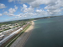
Mount's Bay is a large, sweeping bay on the English Channel
English Channel
The English Channel , often referred to simply as the Channel, is an arm of the Atlantic Ocean that separates southern England from northern France, and joins the North Sea to the Atlantic. It is about long and varies in width from at its widest to in the Strait of Dover...
coast of Cornwall
Cornwall
Cornwall is a unitary authority and ceremonial county of England, within the United Kingdom. It is bordered to the north and west by the Celtic Sea, to the south by the English Channel, and to the east by the county of Devon, over the River Tamar. Cornwall has a population of , and covers an area of...
in the United Kingdom
United Kingdom
The United Kingdom of Great Britain and Northern IrelandIn the United Kingdom and Dependencies, other languages have been officially recognised as legitimate autochthonous languages under the European Charter for Regional or Minority Languages...
, stretching from the Lizard Point
Lizard Point, Cornwall
Lizard Point in Cornwall is at the southern tip of the Lizard Peninsula. It is situated half-a-mile south of Lizard village in the civil parish of Landewednack and approximately 11 miles southeast of Helston....
to Gwennap Head
Gwennap Head
Gwennap Head is the most southerly headland on the south coast of the Penwith peninsula, Cornwall, United Kingdom. The South West Coast Path closely follows the entire coastline around the headland. Its intricate and varied granite cliffs include the famous Chair Ladder crag, making it a popular...
on the eastern side of the Land's End
Land's End
Land's End is a headland and small settlement in west Cornwall, England, within the United Kingdom. It is located on the Penwith peninsula approximately eight miles west-southwest of Penzance....
peninsula. Towards the middle of the bay (and probably the origin of the name) is St Michael's Mount
St Michael's Mount
St Michael's Mount is a tidal island located off the Mount's Bay coast of Cornwall, United Kingdom. It is a civil parish and is united with the town of Marazion by a man-made causeway of granite setts, passable between mid-tide and low water....
. Presenting a benign aspect to summer visitors of a large, scenic, natural harbour; in an onshore winter gale it presents a great danger to shipping as a "maritime trap". Especially in the days of sailing ships with an excess of 150 known wrecks in the nineteenth century.
Geography
Mount's Bay is the biggest bay in Cornwall. Its half-moon shape is similar to that of Donegal BayDonegal Bay
Donegal Bay is an inlet in the northwest of Ireland. Three counties – Donegal to the north and west, Leitrim and Sligo to the south – have shorelines on the bay, which is bounded on the west by the Atlantic Ocean...
in Ireland
Ireland
Ireland is an island to the northwest of continental Europe. It is the third-largest island in Europe and the twentieth-largest island on Earth...
and Cardigan Bay
Cardigan Bay
Cardigan Bay is a large inlet of the Irish Sea, indenting the west coast of Wales between Bardsey Island, Gwynedd in the north, and Strumble Head, Pembrokeshire at its southern end. It is the largest bay in Wales....
in Wales
Wales
Wales is a country that is part of the United Kingdom and the island of Great Britain, bordered by England to its east and the Atlantic Ocean and Irish Sea to its west. It has a population of three million, and a total area of 20,779 km²...
, although, unlike the aforementioned bays, Mount's Bay is relatively sheltered from the prevailing Atlantic westerlies. It is, however, a danger to shipping during onshore southerly and south-easterly gales.
The coast is approximately 42 miles ([67 km) miles from Lizard Point to Gwennap Head. Heading north and west from Lizard Point, the serpentine
Serpentinite
Serpentinite is a rock composed of one or more serpentine group minerals. Minerals in this group are formed by serpentinization, a hydration and metamorphic transformation of ultramafic rock from the Earth's mantle...
and hornblende schist cliffs reach a maximum height of 71 m (233 ft) at Vellan Head and are only broken by small streams and coves such as at Kynance
Kynance Cove
Kynance Cove is a cove in southwest Cornwall, United Kingdom. It is situated on the Lizard peninsula approximately two miles north of Lizard Point...
, Gew-grade and Mullion Cove
Mullion Cove
Mullion Cove is a harbour on the Lizard peninsula in south Cornwall, United Kingdom. It is situated facing west into Mount's Bay approximately six miles south of Helston and one mile southwest of Mullion village....
. After Gunwalloe Fishing Cove the cliffs have the softer look of Devonian
Devonian
The Devonian is a geologic period and system of the Paleozoic Era spanning from the end of the Silurian Period, about 416.0 ± 2.8 Mya , to the beginning of the Carboniferous Period, about 359.2 ± 2.5 Mya...
Meneage Formations of greywacke
Greywacke
Greywacke or Graywacke is a variety of sandstone generally characterized by its hardness, dark color, and poorly sorted angular grains of quartz, feldspar, and small rock fragments or lithic fragments set in a compact, clay-fine matrix. It is a texturally immature sedimentary rock generally found...
and mélange
Mélange
In geology, a mélange is a large-scale breccia, a mappable body of rock characterized by a lack of continuous bedding and the inclusion of fragments of rock of all sizes, contained in a fine-grained deformed matrix. The mélange typically consists of a jumble of large blocks of varied lithologies...
, with erosion a problem west of the naturally dammed ria
Ria
A ria is a coastal inlet formed by the partial submergence of an unglaciated river valley. It is a drowned river valley that remains open to the sea. Typically, rias have a dendritic, treelike outline although they can be straight and without significant branches. This pattern is inherited from the...
of Loe Pool. West of Porthleven
Porthleven
Porthleven is a town, civil parish and fishing port in Cornwall, United Kingdom, near Helston. It is the most southerly port on the island of Great Britain and was originally developed as a harbour of refuge, when this part of the Cornish coastline was recognised as a black spot for wrecks in days...
there are high Devonian slate
Slate
Slate is a fine-grained, foliated, homogeneous metamorphic rock derived from an original shale-type sedimentary rock composed of clay or volcanic ash through low-grade regional metamorphism. The result is a foliated rock in which the foliation may not correspond to the original sedimentary layering...
and granite
Granite
Granite is a common and widely occurring type of intrusive, felsic, igneous rock. Granite usually has a medium- to coarse-grained texture. Occasionally some individual crystals are larger than the groundmass, in which case the texture is known as porphyritic. A granitic rock with a porphyritic...
cliffs to Rinsey Head after which the cliffs are topped by Pleistocene
Pleistocene
The Pleistocene is the epoch from 2,588,000 to 11,700 years BP that spans the world's recent period of repeated glaciations. The name pleistocene is derived from the Greek and ....
periglacial
Periglacial
Periglacial is an adjective originally referring to places in the edges of glacial areas, but it has later been widely used in geomorphology to describe any place where geomorphic processes related to freezing of water occur...
head and have eroded to form sandy beaches such as those at Praa Sands
Praa Sands
Praa Sands is a coastal village in the Parish of Breage, located off the main road between Helston and Penzance in Cornwall, England, UK...
and Kenneggy. These beaches are in deficit and the cliff line is retreating. With the exception of the harder Devonian dolerite and gabbro
Gabbro
Gabbro refers to a large group of dark, coarse-grained, intrusive mafic igneous rocks chemically equivalent to basalt. The rocks are plutonic, formed when molten magma is trapped beneath the Earth's surface and cools into a crystalline mass....
of Cudden Point, the low, eroding cliffs and beaches continue to Mousehole
Mousehole
Mousehole is a village and fishing port in Cornwall, United Kingdom. It is situated approximately 2½ miles south of Penzance on the shore of Mount's Bay.The village is in the civil parish of Penzance...
. This part of the bay is the most populated with the towns of Penzance
Penzance
Penzance is a town, civil parish, and port in Cornwall, England, in the United Kingdom. It is the most westerly major town in Cornwall and is approximately 75 miles west of Plymouth and 300 miles west-southwest of London...
and Marazion
Marazion
Marazion is a civil parish and town in Cornwall, United Kingdom. It is situated on the shore of Mount's Bay, two miles east of Penzance and one mile east of Long Rock.St Michael's Mount is half-a-mile offshore from Marazion...
and the villages of Newlyn
Newlyn
Newlyn is a town and fishing port in southwest Cornwall, England, United Kingdom.Newlyn forms a conurbation with the neighbouring town of Penzance and is part of Penzance civil parish...
and Mousehole. Beyond Mousehole the granite cliffs, rise to 60 m, and are broken by small streams such as at Lamorna Cove
Lamorna
Lamorna is a fishing village and cove in west Cornwall, United Kingdom. It is situated on the Penwith peninsula approximately four miles south of Penzance.-Newlyn School of Art and the Lamorna Colony:...
and Penberth
Penberth
Penberth is a coastal village and cove on the Penwith peninsula in Cornwall, United Kingdom. It is situated approximately seven miles southwest of Penzance.Penberth Cove is one of the last remaining traditional fishing coves in Cornwall...
.
There are small sand dune systems at Church Cove and Poldhu Cove, Porthleven Sands, Praa Sands and from Marazion to Eastern Green, Penzance. The former sand dunes of the Western Green are now covered by Penzance promenade. All, but Marazion to Penzance, are examples of bay dune systems which develop where there is a limited supply of sand trapped within the shelter of two rocky headlands. Church and Poldhu Coves are SSSI
Site of Special Scientific Interest
A Site of Special Scientific Interest is a conservation designation denoting a protected area in the United Kingdom. SSSIs are the basic building block of site-based nature conservation legislation and most other legal nature/geological conservation designations in Great Britain are based upon...
and also have associated climbing dunes which occur when sand is blown inland of the main dune system.
Evidence of higher sea-levels in the past can be seen at Marazion where the town is built on a raised beach
Raised beach
A raised beach, marine terrace, or perched coastline is an emergent coastal landform. Raised beaches and marine terraces are beaches or wave-cut platforms raised above the shore line by a relative fall in the sea level ....
. A second example is the road between Newlyn and Mousehole. Sea levels rise and fall as the ice sheets advance and retreat, and raised beaches now mark the interglacial
Interglacial
An Interglacial period is a geological interval of warmer global average temperature lasting thousands of years that separates consecutive glacial periods within an ice age...
periods when sea levels were higher. Either side of Penzance, on the beaches at Ponsandane and Wherrytown
Wherrytown
Wherrytown is a small settlement in west Cornwall, United Kingdom, situated between Newlyn and Penzance on the east side of the Larigan River. The village bore the brunt of the Ash Wednesday storm on 7 March 1962 with most of the buildings destroyed along with nearly one mile of the seafront from...
, evidence of a 'submerged forest' can be seen at low tide in the form of several fossilised tree trunks. Geologists believe that a forest may have existed here before the most recent sea level rise. This correlates with the Cornish
Cornish language
Cornish is a Brythonic Celtic language and a recognised minority language of the United Kingdom. Along with Welsh and Breton, it is directly descended from the ancient British language spoken throughout much of Britain before the English language came to dominate...
name of St Michael's Mount
St Michael's Mount
St Michael's Mount is a tidal island located off the Mount's Bay coast of Cornwall, United Kingdom. It is a civil parish and is united with the town of Marazion by a man-made causeway of granite setts, passable between mid-tide and low water....
, Carrack Looz en Cooz — literally, "the grey rock in the wood".
On 1st November, 1755, the Lisbon earthquake caused a tsunami
Tsunami
A tsunami is a series of water waves caused by the displacement of a large volume of a body of water, typically an ocean or a large lake...
to strike the Cornish coast at around 14:00. At Mounts Bay the sea rose ten feet at great speed and ebbed at the same rate. Little damage was recorded.
Settlements
There are several coastal towns and villages dotted around Mount's Bay of which the largest is Penzance. To the west are Newlyn, PaulPaul, Cornwall
Paul is a civil parish and village in Cornwall, United Kingdom. It is situated two miles south of Penzance and one mile south of Newlyn.The village of Paul is represented on Penzance Town Council...
, Mousehole and Lamorna. and to the east are Marazion, Perranuthnoe
Perranuthnoe
Perranuthnoe is a civil parish and a village in southwest Cornwall, United Kingdom. The village is situated on the east side of Mount's Bay approximately one mile east of Marazion and four miles east of Penzance....
, Praa Sands, Porthleven
Porthleven
Porthleven is a town, civil parish and fishing port in Cornwall, United Kingdom, near Helston. It is the most southerly port on the island of Great Britain and was originally developed as a harbour of refuge, when this part of the Cornish coastline was recognised as a black spot for wrecks in days...
and Mullion
Mullion, Cornwall
Mullion is a civil parish and village in Cornwall, United Kingdom. It is situated on the Lizard Peninsula approximately five miles south of Helston....
. The bay also incorporates many beaches, coves and features including Prussia Cove
Prussia Cove
Prussia Cove , formerly called the King's Cove, is a small private estate on the coast of Mount's Bay and to the east of Cudden Point, west Cornwall, UK. Part of the area is designated as a Site of Special Scientific Interest , a Geological Conservation Review site and is in an Area of Outstanding...
, Loe Pool (and Loe Bar), Church Cove, Poldhu Cove and Kynance Cove.
In the churchyard wall of the church of St. Paul Aurelian
Paul Aurelian
Paul Aurelian is a 6th century Welsh saint, who became one of the seven founder saints of Brittany....
in Paul is the 1860 monument to Dolly Pentreath
Dolly Pentreath
Dolly Pentreath, or Dorothy Pentreath was probably the last fluent native speaker of the Cornish language, prior to its revival in 1904 and the subsequent small number of children brought up as bilingual native speakers of revived Cornish.She is often stated to have been the last monoglot speaker...
, according to tradition the last native speaker of the Cornish language.
Mount's Bay gives its name to a local secondary school, which is located in Heamoor
Heamoor
Heamoor is a village in Cornwall, United Kingdom. Formerly a secondary settlement of the village of Madron, Heamoor is now a suburb of Penzance and is situated approximately one kilometre northwest of the town centre....
and serves Penzance and the surrounding countryside. Mount's Bay School and Community Sports College (formerly Heamoor Secondary Modern School ) is one of Penzance's comprehensive schools.
RFA Mount's Bay
Commissioned by the Royal Fleet AuxiliaryRoyal Fleet Auxiliary
The Royal Fleet Auxiliary is a civilian-manned fleet owned by the British Ministry of Defence. The RFA enables ships of the United Kingdom Royal Navy to maintain operations around the world. Its primary role is to supply the Royal Navy with fuel, ammunition and supplies, normally by replenishment...
in 2006, RFA Mount's Bay
RFA Mounts Bay (L3008)
RFA Mounts Bay is a Bay class auxiliary landing ship dock of the Royal Fleet Auxiliary. She is named after Mount's Bay in Cornwall.-Design and construction:...
is the latest-design Landing Ship Dock, the Bay Class used by the Royal Navy. Mount's Bay has good affiliations with the Sea Cadet Unit TS Zephyr in Caterham
Caterham
Caterham is a town in the Tandridge District of Surrey, England. The town is geographically divided into two sections: Caterham on the Hill and Caterham Valley - the main town centre. The town lies close to the A22, a few miles south of Croydon, in a valley cut into the dip slope of the North Downs...
, Surrey.