
Riccarton, Ayrshire
Encyclopedia
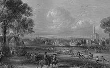
Riccarton is a village and parish in East Ayrshire, Scotland. It lies across the River Irvine
from Kilmarnock
. The river Irvine divides the parishes of Riccarton and Kilmarnock and the river used to form the boundary between the districts of Kyle and Cunninghame.
Riccarton has effectively been absorbed into Kilmarnock
, partly through the growth of council housing estates at Shortlees, Witchknowe and Burnpark, and later by the improvements to the A71 (T) road, the building of which, together with associated interchanges, effectively made the old village centre into a large traffic island.
 A pre-reformation Riccarton parish church stood in the centre of the old burial ground; first noted, as a chapel, in 1229, sub-ordinate to the church of Dundonald
.Groome, Francis H. (1903). Ordnance Gazetteer of Scotland. Pub. Caxton. London. P. 1379. It was granted by Walter, High Steward of Scotland, to the short lived independent convent of Dalmulin. This convent, dissolved in 1238, and the 'chapel' was given to the monastery of Paisley
, becoming the parish church which still belonged to the monks. The last patrons were the Cunninghames of Caprington, whose impressive memorial still stands; some of the Campbells of Treesbank are also interred here. The old cemetery has a number of interesting pre-reformation style gravestones, ornamented with scenes of men ploughing with oxen, one with a bodkin
, shears and iron, another with millstones, wheels, and other gearing, and even a few with Garden of Eden
scenes. The oldest discernible stone is marked 1641. Unfortunately many are very worn and heraldic devices, etc. can no longer be made out with any certainty.
From the presbytery records it would appear to have been rebuilt in 1725. It was replaced by the present church (at NS 4282 3639) in 1823, which was built on the old Judgement or Moot hill
of the barony of Riccarton. Of the old church in the small churchyard nearby, nothing now remains above ground, the stones being used to build a single story house close to the old bridge.
The manse no longer exists, however it had a claim to significance in that it had a mantelpiece in its kitchen which came from the dining room of Riccarton castle.
Protestant minister of Riccarton lampooned by Robert Burns
in his poem The Holy Fair. Burns has him preaching with hell-fire roaring, enough to send the Devil himself back to his hot hell in fright.
during his childhood. Gilbert's Scots nickname was 'Jop' and as a man of great stature and generally impressive appearance he was chosen by Edward I to carry the sacred banner of Saint John of Beverley at the head of the English army at the Battle of Dunbar
in 1296 after voluntarily joining the English army. He had served under Edward in Flanders
and Picardy
and had been selected as a pursuivant
or herald. On hearing of William Wallace's insurrection Gilbert deserted Edward and joined William's rebellion, bringing invaluable intelligence about the English army and being rewarded with the position of standard-bearer.
 The Rev. Alexander Moodie, minister of the parish, is buried in the old cemetery. Robbie Burns mentions him in The Holy Fair.
Sandy McCrone was a blind fiddler who is remembered for having climbed to the top of the new church when the scaffolding was still in place and placed a potato on the beak of the weathercock.
William Stevenson was a local beggar who came from Dunlop
. About 1787 he separated from his wife and made the unusual pledge that if either of them were to make an attempt at reconciliation then that person was to pay the other a £100; a considerable sum in those times. When he died it was found that he was worth around nine hundred pounds. He set aside money for all the beggars in Ayrshire to come and see his body lying in state and then enjoy a great feast in his honour.
Sir James Shaw, Bart., a Lord Mayor of London was born at Mosshead farm on the Treesbank estate in 1764. His statue now stands outside the Dick Institute in Kilmarnock. Sir James endeared himself to Scotland by the active part which he took in raising money in London for the widow and children of Robbie Burns.
where justice was administered by the old baron court of Riccarton. Paterson in 1863 called it the "Moat." Soil from the foundations of the new church on the old moot hill was used to fill up part of the river bed when its course was changed at East Shaw Street, and this area though north of the Irvine still lies in Riccarton parish. Witchknowe is an area of Riccarton named after a low hill. No definite site for the 'Gallow's hill' associated with the Moot hill has been identified and this is a candidate, together with the 'Castle hill.'
The 'Castle Hill' in 1895 was a round-topped mound with an oval base close to Damhead House. It was 26 paces in its longest diameter at the base, 15 feet (4.6 m) high on one side and 4 in 6 in (1.37 m) on the other. It was covered with trees and had a seat and a path to the top.
, William Wallace first sought refuge in Riccarton castle; another time being after he had revenged his uncle's death at the Barns of Ayr
.
 A little below the watermeetings of the Irvine and the Kilmarnock Water took place a pivotal incident in 1297 which led to the Scottish Nation regaining its independence following what was effectively its conquest by Edward I of England
.
Sir William Wallace was fishing on the Irvine at Monksholm also Maxholm farm, about half a mile to the west of old Riccarton castle, when a troop of English soldiers dismounted and demanded that he give up his catch. He offered to share, but this was refused and he was grossly insulted by the soldiers for his temerity. He had no weapons, however he used his fishing rod to disarm one soldier and then killed him with his own sword. He similarly dispatched two others and the remaining soldiers then fled.
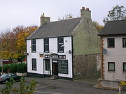
He went to his uncle's castle, the nearby Riccarton castle and took on the disguise of a woman working at her spinning-wheel, thereby eluding the vengeful English troops. In the following months an uprising slowly gained impetus through the example of one unarmed Scotsman killing three armed soldiers. A thorn tree called the "Bickering Bush" stood nearby and its site is marked on the 1860 OS map and a public house by that name used to stand in Riccarton, although another still exists in Bonnyton, Kilmarnock.
John Wallace of Riccarton married the heiress of Craigie
castle and this became the principal residence , the old castle being allowed to fall into ruins. In 1875 all that remained of the castle was some stately trees, including a pear tree supposedly planted by William Wallace.
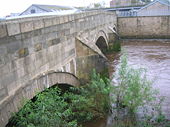 Riccarton Bridge is an 18th century 3-span, segmental arched bridge, with dressed stone arch rings, rubble spandrels and triangular cutwaters. The first recorded wheeled vehicles to be used in Ayrshire were carts offered gratis to labourers working on Riccarton Bridge, Kilmarnock
, in 1726, and even then some of the labourers refused them. The 1860 OS map shows that stepping stones crossed the river just upstream of the old bridge and just before the confluence of the Kilmarnock water
with the river Irvine.
maintenance. Even after recourse to law the committee still failed to obtain any money from Riccarton and Galston parishes.McClure, David (1994). Tolls and Tacksmen. Ayr Arch & Nat Hist Soc. Ayrshire Monograph No.13. P. 21 & 22.
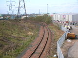 The village had a railway station by this name on the Gatehead and Hurlford
branch of the Glasgow and South Western Railway
. Part of the line remains open to supply a petrol depot in Kilmarnock. The remains of the station were extant until the new Kilmarnock bypass removed all traces. It was a goods only station (no passengers) as the line never had a publicly advertised passenger service. It is listed in 1929 as 'Riccarton and Craigie' by the London, Midland and Scottish Railway
, one of the stations which the company conveyed goods to. It closed officially on 5 July 1965, originally just called Riccarton and renamed in 1905.
 This grand Georgian mansion and its 240 acre (0.9712464 km²) of woodlands and gardens, including a notable rock garden, were gifted to Kilmarnock by the Misses Buchanan, Elizabeth, Jane and Margaret, in around 1879. The ladies were the daughters of George Buchanan, a Glasgow merchant. recalled that the Bellfield Park, adjoining, the beauty and beneficience of which touches every heart. Here flowers and plants are grown to perfection and every shrubbery cultivated and tree pruned to a nicety.
The house was demolished in 1970, much of the land was used for building council housing and the remainder is now used as a public park and playing fields.
River Irvine
The River Irvine is a river flowing through southwest Scotland, with its watershed on the Lanarkshire border of Ayrshire at an altitude of above sea-level, near Drumclog, and SW by W of Strathaven...
from Kilmarnock
Kilmarnock
Kilmarnock is a large burgh in East Ayrshire, Scotland, with a population of 44,734. It is the second largest town in Ayrshire. The River Irvine runs through its eastern section, and the Kilmarnock Water passes through it, giving rise to the name 'Bank Street'...
. The river Irvine divides the parishes of Riccarton and Kilmarnock and the river used to form the boundary between the districts of Kyle and Cunninghame.
| Etymology |
| The origin of the name 'Riccarton' is from a corruption of 'Richard's town'. This Richard was Sir Richard Wallace, uncle of William Wallace William Wallace Sir William Wallace was a Scottish knight and landowner who became one of the main leaders during the Wars of Scottish Independence.... . |
History
The village became a Burgh of Barony in 1638, but its civic powers were never exercised. Riccarton is also sometimes called Ellerslie. In 1875 Riccarton had a population of 1889, but by 1951 that had increased to between 7000 and 8000; many of whom were employed at the Glenfield Works in Kilmarnock.Riccarton has effectively been absorbed into Kilmarnock
Kilmarnock
Kilmarnock is a large burgh in East Ayrshire, Scotland, with a population of 44,734. It is the second largest town in Ayrshire. The River Irvine runs through its eastern section, and the Kilmarnock Water passes through it, giving rise to the name 'Bank Street'...
, partly through the growth of council housing estates at Shortlees, Witchknowe and Burnpark, and later by the improvements to the A71 (T) road, the building of which, together with associated interchanges, effectively made the old village centre into a large traffic island.
The Barony of Riccarton
The ancient 109 merkland barony included 54 separate landholdings, including the coalheughs of Riccarton and all the buildings, orchards, woods, mills, and fishings (salmon and others). Riccarton and Shaws mill were included. Also the £17 lands of Kaimshill, Auchindinane and Hunthall, oddly also the £5 land of Elderslie in Renfrewshire, the 4 merklands of Inchgotrig and the 2 merklands of Holme.The churches
Dundonald
Dundonald is a large settlement in County Down, Northern Ireland. It lies east of Belfast and is often deemed to be a suburb of the city. It includes the large housing estate of Ballybeen, and many new housing estates have emerged in the past ten years....
.Groome, Francis H. (1903). Ordnance Gazetteer of Scotland. Pub. Caxton. London. P. 1379. It was granted by Walter, High Steward of Scotland, to the short lived independent convent of Dalmulin. This convent, dissolved in 1238, and the 'chapel' was given to the monastery of Paisley
Paisley
Paisley is the largest town in the historic county of Renfrewshire in the west central Lowlands of Scotland and serves as the administrative centre for the Renfrewshire council area...
, becoming the parish church which still belonged to the monks. The last patrons were the Cunninghames of Caprington, whose impressive memorial still stands; some of the Campbells of Treesbank are also interred here. The old cemetery has a number of interesting pre-reformation style gravestones, ornamented with scenes of men ploughing with oxen, one with a bodkin
Bodkin
Bodkin may refer to:* One of the fourteen Tribes of Galway* Bodkin point, a type of arrowhead* Bodkin needle, a blunt slender instrument with a large eye for drawing tape or ribbon through a loop or hem.-People:* Edward Bodkin, an American cutter...
, shears and iron, another with millstones, wheels, and other gearing, and even a few with Garden of Eden
Garden of Eden
The Garden of Eden is in the Bible's Book of Genesis as being the place where the first man, Adam, and his wife, Eve, lived after they were created by God. Literally, the Bible speaks about a garden in Eden...
scenes. The oldest discernible stone is marked 1641. Unfortunately many are very worn and heraldic devices, etc. can no longer be made out with any certainty.
From the presbytery records it would appear to have been rebuilt in 1725. It was replaced by the present church (at NS 4282 3639) in 1823, which was built on the old Judgement or Moot hill
Moot hill
A moot hill or mons placiti is a hill or mound historically used as an assembly or meeting place. In early medieval Britain, such hills were used for "moots", meetings of local people to settle local business. Among other things, proclamations might be read; decisions might be taken; court cases...
of the barony of Riccarton. Of the old church in the small churchyard nearby, nothing now remains above ground, the stones being used to build a single story house close to the old bridge.
The manse no longer exists, however it had a claim to significance in that it had a mantelpiece in its kitchen which came from the dining room of Riccarton castle.
Sawney Moodie
Mr. Moodie was the Auld-LichtAnti-Burgher
The Anti-Burghers were opponents of the Burgher Oath on theological grounds.In 1733 the First Secession from the Church of Scotland resulted in the creation of the "Associate Presbytery". This church split in 1747 over the issue of the Burgher Oath, which required holders of public offices to...
Protestant minister of Riccarton lampooned by Robert Burns
Robert Burns
Robert Burns was a Scottish poet and a lyricist. He is widely regarded as the national poet of Scotland, and is celebrated worldwide...
in his poem The Holy Fair. Burns has him preaching with hell-fire roaring, enough to send the Devil himself back to his hot hell in fright.
Local worthies and eccentrics
Gilbert de Grimsby was born at Riccarton and would have known William WallaceWilliam Wallace
Sir William Wallace was a Scottish knight and landowner who became one of the main leaders during the Wars of Scottish Independence....
during his childhood. Gilbert's Scots nickname was 'Jop' and as a man of great stature and generally impressive appearance he was chosen by Edward I to carry the sacred banner of Saint John of Beverley at the head of the English army at the Battle of Dunbar
Battle of Dunbar (1296)
The Battle of Dunbar was the only significant field action in the campaign of 1296. King Edward I of England had invaded Scotland in 1296 to punish King John Balliol for his refusal to support English military action in France.-Background:...
in 1296 after voluntarily joining the English army. He had served under Edward in Flanders
Flanders
Flanders is the community of the Flemings but also one of the institutions in Belgium, and a geographical region located in parts of present-day Belgium, France and the Netherlands. "Flanders" can also refer to the northern part of Belgium that contains Brussels, Bruges, Ghent and Antwerp...
and Picardy
Picardy
This article is about the historical French province. For other uses, see Picardy .Picardy is a historical province of France, in the north of France...
and had been selected as a pursuivant
Pursuivant
A pursuivant or, more correctly, pursuivant of arms, is a junior officer of arms. Most pursuivants are attached to official heraldic authorities, such as the College of Arms in London or the Court of the Lord Lyon in Edinburgh. In the mediaeval era, many great nobles employed their own officers of...
or herald. On hearing of William Wallace's insurrection Gilbert deserted Edward and joined William's rebellion, bringing invaluable intelligence about the English army and being rewarded with the position of standard-bearer.
Sandy McCrone was a blind fiddler who is remembered for having climbed to the top of the new church when the scaffolding was still in place and placed a potato on the beak of the weathercock.
William Stevenson was a local beggar who came from Dunlop
Dunlop, East Ayrshire
Dunlop is a village and parish in East Ayrshire, Scotland. It lies on the A735, north-east of Stewarton, seven miles from Kilmarnock. The road runs on to Lugton and the B706 enters the village from Beith.-The village:...
. About 1787 he separated from his wife and made the unusual pledge that if either of them were to make an attempt at reconciliation then that person was to pay the other a £100; a considerable sum in those times. When he died it was found that he was worth around nine hundred pounds. He set aside money for all the beggars in Ayrshire to come and see his body lying in state and then enjoy a great feast in his honour.
Sir James Shaw, Bart., a Lord Mayor of London was born at Mosshead farm on the Treesbank estate in 1764. His statue now stands outside the Dick Institute in Kilmarnock. Sir James endeared himself to Scotland by the active part which he took in raising money in London for the widow and children of Robbie Burns.
The Seat of Judgement
The present 1823 parish church of Riccarton stands on a mound which is partly natural and partly artificial and which was formerly called "Seat of Judgement", having been a court or moot hillMoot hill
A moot hill or mons placiti is a hill or mound historically used as an assembly or meeting place. In early medieval Britain, such hills were used for "moots", meetings of local people to settle local business. Among other things, proclamations might be read; decisions might be taken; court cases...
where justice was administered by the old baron court of Riccarton. Paterson in 1863 called it the "Moat." Soil from the foundations of the new church on the old moot hill was used to fill up part of the river bed when its course was changed at East Shaw Street, and this area though north of the Irvine still lies in Riccarton parish. Witchknowe is an area of Riccarton named after a low hill. No definite site for the 'Gallow's hill' associated with the Moot hill has been identified and this is a candidate, together with the 'Castle hill.'
The 'Castle Hill' in 1895 was a round-topped mound with an oval base close to Damhead House. It was 26 paces in its longest diameter at the base, 15 feet (4.6 m) high on one side and 4 in 6 in (1.37 m) on the other. It was covered with trees and had a seat and a path to the top.
Riccarton castle and the William Wallace connection
The name Wallace was spelled in various ways, such as 'Waleys', 'Walensis', 'Walays', etc. The family were the barons of Riccarton and it is said that Wallace's father was born here. Some go so far as to suggest that William Wallace himself was born in Riccarton. After his murder of Selby, Governor of DundeeDundee
Dundee is the fourth-largest city in Scotland and the 39th most populous settlement in the United Kingdom. It lies within the eastern central Lowlands on the north bank of the Firth of Tay, which feeds into the North Sea...
, William Wallace first sought refuge in Riccarton castle; another time being after he had revenged his uncle's death at the Barns of Ayr
Ayr
Ayr is a town and port situated on the Firth of Clyde in south-west Scotland. With a population of around 46,000, Ayr is the largest settlement in Ayrshire, of which it is the county town, and has held royal burgh status since 1205...
.
Edward I of England
Edward I , also known as Edward Longshanks and the Hammer of the Scots, was King of England from 1272 to 1307. The first son of Henry III, Edward was involved early in the political intrigues of his father's reign, which included an outright rebellion by the English barons...
.
Sir William Wallace was fishing on the Irvine at Monksholm also Maxholm farm, about half a mile to the west of old Riccarton castle, when a troop of English soldiers dismounted and demanded that he give up his catch. He offered to share, but this was refused and he was grossly insulted by the soldiers for his temerity. He had no weapons, however he used his fishing rod to disarm one soldier and then killed him with his own sword. He similarly dispatched two others and the remaining soldiers then fled.
He went to his uncle's castle, the nearby Riccarton castle and took on the disguise of a woman working at her spinning-wheel, thereby eluding the vengeful English troops. In the following months an uprising slowly gained impetus through the example of one unarmed Scotsman killing three armed soldiers. A thorn tree called the "Bickering Bush" stood nearby and its site is marked on the 1860 OS map and a public house by that name used to stand in Riccarton, although another still exists in Bonnyton, Kilmarnock.
John Wallace of Riccarton married the heiress of Craigie
Craigie
-Places:Australia*Craigie, Western Australia, a suburb of PerthScotland*Craigie, Ayrshire, a small village in East Ayrshire,*Craigie Castle, Ayrshire*Scottish feudal Barony of Craigie, a feudal barony in Dundee-People:...
castle and this became the principal residence , the old castle being allowed to fall into ruins. In 1875 all that remained of the castle was some stately trees, including a pear tree supposedly planted by William Wallace.
Death at Riccarton's Nether ford
At the Nether Ford on the Irvine near Riccarton, Robert the Bruce in 1307 sent Sir James Douglas to intercept the English soldiers commanded by Sir Philip de Mowbray. The English were ambushed as they crossed the ford on the Irvine and sixty lay dead before the panic-stricken survivors fled in panic.Riccarton old bridge
Kilmarnock
Kilmarnock is a large burgh in East Ayrshire, Scotland, with a population of 44,734. It is the second largest town in Ayrshire. The River Irvine runs through its eastern section, and the Kilmarnock Water passes through it, giving rise to the name 'Bank Street'...
, in 1726, and even then some of the labourers refused them. The 1860 OS map shows that stepping stones crossed the river just upstream of the old bridge and just before the confluence of the Kilmarnock water
River Irvine
The River Irvine is a river flowing through southwest Scotland, with its watershed on the Lanarkshire border of Ayrshire at an altitude of above sea-level, near Drumclog, and SW by W of Strathaven...
with the river Irvine.
The Toll Road
Riccarton parish was often in dispute with the Kilmarnock to Cumnock committee over the payment of so called 'conversion' money for the Toll RoadToll road
A toll road is a privately or publicly built road for which a driver pays a toll for use. Structures for which tolls are charged include toll bridges and toll tunnels. Non-toll roads are financed using other sources of revenue, most typically fuel tax or general tax funds...
maintenance. Even after recourse to law the committee still failed to obtain any money from Riccarton and Galston parishes.McClure, David (1994). Tolls and Tacksmen. Ayr Arch & Nat Hist Soc. Ayrshire Monograph No.13. P. 21 & 22.
Riccarton mill and cottages
At Map reference: NS 4463 3701 lies the old Riccarton mill with its associated cottages. The mill wheel has gone and the building has been converted into a private house. One miller was named Goudie and his son was likewise a miller in Alloway until he took a lease on Burns's Cottage and ran it as a pub.Riccarton Institute
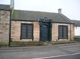
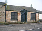
John Galloway, Esq., of Barleith and Dollars Collieries built an institute in New Street Riccarton for the use of the working-men in the locality. The building still survives as a Community Centre run by East Ayrshire Council.Riccarton and Craigie railway station
Hurlford
Hurlford is a village in East Ayrshire, Scotland. Including Crookedholm, it has a population of 4,968. Hurlford's former names include Whirlford and Hurdleford. The village was named Whirlford as a result of a ford crossing the River Irvine east of Hurlford Cross, near Shawhill...
branch of the Glasgow and South Western Railway
Glasgow and South Western Railway
The Glasgow and South Western Railway , one of the pre-grouping railway companies, served a triangular area of south-west Scotland, between Glasgow, Stranraer and Carlisle...
. Part of the line remains open to supply a petrol depot in Kilmarnock. The remains of the station were extant until the new Kilmarnock bypass removed all traces. It was a goods only station (no passengers) as the line never had a publicly advertised passenger service. It is listed in 1929 as 'Riccarton and Craigie' by the London, Midland and Scottish Railway
London, Midland and Scottish Railway
The London Midland and Scottish Railway was a British railway company. It was formed on 1 January 1923 under the Railways Act of 1921, which required the grouping of over 120 separate railway companies into just four...
, one of the stations which the company conveyed goods to. It closed officially on 5 July 1965, originally just called Riccarton and renamed in 1905.
Bellfield Estate
The house was demolished in 1970, much of the land was used for building council housing and the remainder is now used as a public park and playing fields.