
Burwood, Victoria
Encyclopedia
Burwood is a suburb in Melbourne
, Victoria
, Australia
, 17 km east from Melbourne's central business district
. Its Local Government Area is largely the City of Whitehorse
but includes the City of Monash
in its south west corner. At the 2006 Census, Burwood had a population of 11,886.
The name "Burwood" (later "Invergowrie") was the name of a house built by Sir James Palmer
in Hawthorn West
in 1852. The original settlement was centred near Burwood Cemetery and the Police Station, but the focus shifted to the intersection of Warrigal Road
and Toorak Road with later commercial development. The suburb later spread westwards to the Hartwell railway station, which was renamed as Burwood railway station
.
By 1904, Burwood had a population of 600 and had a post office, two hotels, a savings bank and a number of churches. The township at that time was surrounded by farms and market gardens. Albers’ Daffodil Farm is typical of the local market gardens and was established in 1934. It operated on the site now by Deakin University’s Burwood Campus until the site was sold to the government in 1951.
The extension of the Toorak Road tramline
in 1912 was a catalyst for residential development in the area. Following World War II
, development headed east along Burwood Highway
for juvenile wards of the state was located at Burwood.
in 1989.
) purchased 41 acres (165,921.3 m²) of land on Burwood Highway in 1951 for a school, which was opened in 1959. This school was closed down in December 2009 to be replaced by a large housing development.
, it had a 652 car capacity, later increasing to 743. The drive-in was located near the intersection of Burwood Highway and McComas Grove in a natural amphitheatre
setting provided by the Gardiners Creek
Valley. The screen was located on a high point on the other side of the creek from the viewing area. The first film publicly screened was On the Riviera
starring Danny Kaye
and Gene Tierney
. The drive in was very popular in its early years, often causing traffic jams in the local area. A playground was provided for children, which included a motorised carousel
.
Following a decline in audience numbers over a number of years, the drive-in closed on 22 June 1983, with a screening of We of the Never Never
and Local Hero
.
, Gardiners Creek
and Eley Road. It is bounded to the east by Middleborough Road and to the west by Warrigal Road
. The southern boundary runs near to Carlyle and Zodiac Streets then along Gardiners Creek and subsequently in approximate alignment with Ashwood Drive, Montpellier Road, Arthur Street, Huntingdale Road and Highbury Road.
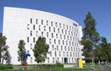
The most prominent feature of the Burwood landscape is Building C (The Alfred Deakin
Building) of Deakin University.
and Gardiners Creek Reserve, the latter which has a shared bicycle and pedestrian path. Sports facilities include Bennettswood Sports Ground and Bennettswood Bowling Club. Burwood Reserve and Burwood Bowling Club are located in nearby Glen Iris
.
Golfers play at the course of the Wattle Park Public Golf Club on Riversdale Road.
Tram route 75
runs from Melbourne
to Vermont South, traverses the suburb along Burwood Highway. There is no train service in the suburb, with Burwood railway station
located in the adjoining suburb of Glen Iris
.
There are a number of bus routes which connect the suburb to surrounding areas.
Melbourne
Melbourne is the capital and most populous city in the state of Victoria, and the second most populous city in Australia. The Melbourne City Centre is the hub of the greater metropolitan area and the Census statistical division—of which "Melbourne" is the common name. As of June 2009, the greater...
, Victoria
Victoria (Australia)
Victoria is the second most populous state in Australia. Geographically the smallest mainland state, Victoria is bordered by New South Wales, South Australia, and Tasmania on Boundary Islet to the north, west and south respectively....
, Australia
Australia
Australia , officially the Commonwealth of Australia, is a country in the Southern Hemisphere comprising the mainland of the Australian continent, the island of Tasmania, and numerous smaller islands in the Indian and Pacific Oceans. It is the world's sixth-largest country by total area...
, 17 km east from Melbourne's central business district
Melbourne city centre
Melbourne City Centre is an area of Melbourne in Victoria, Australia. It is not to be confused with the larger local government area of the City of Melbourne...
. Its Local Government Area is largely the City of Whitehorse
City of Whitehorse
The City of Whitehorse is a Local Government Area in Victoria, Australia. It is located in the eastern suburbs of Melbourne. It has an area of and has a estimated population of 155,725 people....
but includes the City of Monash
City of Monash
The City of Monash is a Local Government Area in Melbourne, Victoria, Australia. It is located in the southeastern suburbs of Melbourne and has an area of 81.0 square kilometres and has a estimated population of 176,069 people...
in its south west corner. At the 2006 Census, Burwood had a population of 11,886.
History
The first settlement in the area, known as Ballyshanassy was surveyed in 1858. The settlement changed name to Norwood and subsequently Burwood in 1879. The Post Office opened on 1 May 1853 as Ballyshanassy and was renamed Burwood around June 1879.The name "Burwood" (later "Invergowrie") was the name of a house built by Sir James Palmer
James Frederick Palmer
Sir James Frederick Palmer was a medical practitioner, Victorian pioneer, first President of the Victorian Legislative Council and former Mayor of Melbourne.-Early life:...
in Hawthorn West
Hawthorn, Victoria
Hawthorn is a suburb in Melbourne, Victoria, Australia, east from Melbourne's central business district. Its Local Government Area is the City of Boroondara...
in 1852. The original settlement was centred near Burwood Cemetery and the Police Station, but the focus shifted to the intersection of Warrigal Road
Warrigal Road
Warrigal Road is a major inner urban road in southeastern Melbourne, Australia. On weekdays, it is usually congested as it runs through many major suburbs along its route, traversing Melbourne's inner eastern and south-eastern suburbs. This includes suburbs such as Chadstone, Oakleigh, and...
and Toorak Road with later commercial development. The suburb later spread westwards to the Hartwell railway station, which was renamed as Burwood railway station
Burwood railway station, Melbourne
Burwood is a railway station on the Alamein line in Melbourne, Victoria, Australia. It is located between Trent Street and Bardolph Street, in the suburb of Glen Iris. It is located from Flinders Street Station in the centre of Melbourne and is in Metcard Zone 1.-Facilities:The station has two...
.
By 1904, Burwood had a population of 600 and had a post office, two hotels, a savings bank and a number of churches. The township at that time was surrounded by farms and market gardens. Albers’ Daffodil Farm is typical of the local market gardens and was established in 1934. It operated on the site now by Deakin University’s Burwood Campus until the site was sold to the government in 1951.
The extension of the Toorak Road tramline
Melbourne tram route 75
Tram route 75 is a public transport service in Melbourne, Victoria, Australia. It runs from the corner of Spencer Street and La Trobe Street in the city centre to Vermont South in the eastern suburbs....
in 1912 was a catalyst for residential development in the area. Following World War II
World War II
World War II, or the Second World War , was a global conflict lasting from 1939 to 1945, involving most of the world's nations—including all of the great powers—eventually forming two opposing military alliances: the Allies and the Axis...
, development headed east along Burwood Highway
Burwood Highway
Burwood Highway is a major transportation link with Melbourne's eastern suburbs. It begins in the suburb of Kooyong, Melbourne at the junction of the Monash Freeway as Toorak Road between Monash Freeway and Warrigal Road, and finishes in Belgrave, Victoria in the Dandenong Ranges...
Allambie
The Allambie Reception CentreAllambie Reception Centre
Allambie Reception Centre was a Victorian Children's Home run by the Family Welfare Division of the Social Welfare Department and opened in 1960. Allambie was located at 70 Elgar Road, Burwood, Victoria, Australia...
for juvenile wards of the state was located at Burwood.
Burwood Boys Home
Burwood Boys Home, located on Warrigal Road, was founded in 1895 by Robert Campbell Edwards, who was concerned about the number of children living on the streets of Melbourne. The facility changed its name to Burwood Children's Home when girls began to be admitted after 1972. It was closed in 1986.Orana Methodist Children's Home
In the 1950s, 1960s and 1970s the Methodist Church developed residential units (cottages) on the site of 87 Elgar Road Burwood for the care of abandoned and neglected children, children that were deemed wards of the state of Victoria. This site was sold and relocated to Meadow HeightsMeadow Heights, Victoria
Meadow Heights is a suburb in Melbourne, Victoria, Australia, 18 km north from Melbourne's central business district. Its Local Government Area is the City of Hume...
in 1989.
Princess Elizabeth Kindergarten for the Deaf
The Princess Elizabeth Kindergarten for the Deaf, the first facility of its kind in Australia, was opened on a site at 90 Elgar Road in 1950. It was later known as the Princess Elizabeth Junior School for Deaf ChildrenVision Australia
The Royal Victorian Institute of the Blind (now Vision AustraliaVision Australia
Vision Australia is a not-for-profit organisation and Australia's largest provider of services for people with blindness and low vision.-Vision and Mission:...
) purchased 41 acres (165,921.3 m²) of land on Burwood Highway in 1951 for a school, which was opened in 1959. This school was closed down in December 2009 to be replaced by a large housing development.
Drive-in theatre
The Burwood Skyline, opened in February 1954, was Australia's first drive-in theatre. Operated by HoytsHoyts
The Hoyts Group is an Australian company consisting of Hoyts Exhibition, Hoyts Distribution and Val Morgan.Hoyts Exhibition manages 450 screens across 40 Australian and 10 New Zealand cinema complexes; making it Australia's second largest cinema chain. Val Morgan, the cinema advertising arm of the...
, it had a 652 car capacity, later increasing to 743. The drive-in was located near the intersection of Burwood Highway and McComas Grove in a natural amphitheatre
Amphitheatre
An amphitheatre is an open-air venue used for entertainment and performances.There are two similar, but distinct, types of structure for which the word "amphitheatre" is used: Ancient Roman amphitheatres were large central performance spaces surrounded by ascending seating, and were commonly used...
setting provided by the Gardiners Creek
Gardiners Creek Trail
The Gardiners Creek Trail is a shared use path for cyclists and pedestrians, which follows Gardiners Creek through the eastern suburbs of Melbourne, Victoria, Australia....
Valley. The screen was located on a high point on the other side of the creek from the viewing area. The first film publicly screened was On the Riviera
On the Riviera
On the Riviera is a 1951 musical comedy film made by 20th Century Fox. It was directed by Walter Lang, produced by Sol C. Siegel from a screenplay by Valentine Davies and Phoebe and Henry Ephron, based on the play The Red Cat by Rudolph Lothar and Hans Adler, with dance sequences choreographed and...
starring Danny Kaye
Danny Kaye
Danny Kaye was a celebrated American actor, singer, dancer, and comedian...
and Gene Tierney
Gene Tierney
Gene Eliza Tierney was an American film and stage actress. Acclaimed as one of the great beauties of her day, she is best remembered for her performance in the title role of Laura and her Academy Award-nominated performance for Best Actress in Leave Her to Heaven .Other notable roles include...
. The drive in was very popular in its early years, often causing traffic jams in the local area. A playground was provided for children, which included a motorised carousel
Carousel
A carousel , or merry-go-round, is an amusement ride consisting of a rotating circular platform with seats for riders...
.
Following a decline in audience numbers over a number of years, the drive-in closed on 22 June 1983, with a screening of We of the Never Never
We of the Never Never
We of the Never Never is an autobiographical novel by Jeannie Gunn. Although published as a novel, it is an account of the author's experiences in 1902 at Elsey Station near Mataranka, Northern Territory in which she changed the names of people to obscure their identities. She published this book...
and Local Hero
Local Hero
Local Hero is a 1983 Scottish comedy-drama film starring Peter Riegert and Burt Lancaster. It was directed by Bill Forsyth and produced by David Puttnam....
.
Geography
Burwood is bounded to the north by Riversdale Road, the northern boundary of Deakin UniversityDeakin University
Deakin University is an Australian public university with nearly 40,000 higher education students in 2010. It receives more than A$600 million in operating revenue annually, and controls more than A$1.3 billion in assets. It received more than A$35 million in research income in 2009 and had 835...
, Gardiners Creek
Gardiners Creek Trail
The Gardiners Creek Trail is a shared use path for cyclists and pedestrians, which follows Gardiners Creek through the eastern suburbs of Melbourne, Victoria, Australia....
and Eley Road. It is bounded to the east by Middleborough Road and to the west by Warrigal Road
Warrigal Road
Warrigal Road is a major inner urban road in southeastern Melbourne, Australia. On weekdays, it is usually congested as it runs through many major suburbs along its route, traversing Melbourne's inner eastern and south-eastern suburbs. This includes suburbs such as Chadstone, Oakleigh, and...
. The southern boundary runs near to Carlyle and Zodiac Streets then along Gardiners Creek and subsequently in approximate alignment with Ashwood Drive, Montpellier Road, Arthur Street, Huntingdale Road and Highbury Road.
The most prominent feature of the Burwood landscape is Building C (The Alfred Deakin
Alfred Deakin
Alfred Deakin , Australian politician, was a leader of the movement for Australian federation and later the second Prime Minister of Australia. In the last quarter of the 19th century, Deakin was a major contributor to the establishment of liberal reforms in the colony of Victoria, including the...
Building) of Deakin University.
Shopping Centres
The main Burwood shopping centre is located at the intersection of Warrigal Road and Burwood Highway. Another shopping strip is located at Bennettswood (corner of Burwood Highway and Station Street).High schools
- Burwood High School
- Burwood Technical School
- Burwood Heights High School (opened 1970)
- Wattle Park High School (1962–1992)
Private schools
- Presbyterian Ladies' CollegePresbyterian Ladies' College, MelbournePresbyterian Ladies' College, Melbourne , is an independent,private, Presbyterian, day and boarding school predominantly for girls, located in Burwood, an eastern suburb of Melbourne, Victoria, Australia....
- Emmaus CollegeEmmaus College (Burwood)Emmaus College is a Coeducational Catholic secondary college which serves the middle, eastern suburbs of Melbourne, Australia. The school has a Junior Campus in Vermont South and a VCE campus in Burwood. It has a population of around 1200 students and slowly growing. Emmaus College is a member...
– VCE campus - Mount Scopus College – Gandel Campus
- St Scholastica's Primary School
- St. Benedicts School
Primary schools
- Bennettswood Primary School
- Burwood Primary School
- Wattle Park Primary School
Sports and recreation
Parks in the suburb include Wattle ParkWattle Park, Melbourne
Wattle Park is a public park in Melbourne, Australia, located in the suburb of Burwood. It is known for its plantation of 12,000 wattle trees. It is currently maintained by Parks Victoria....
and Gardiners Creek Reserve, the latter which has a shared bicycle and pedestrian path. Sports facilities include Bennettswood Sports Ground and Bennettswood Bowling Club. Burwood Reserve and Burwood Bowling Club are located in nearby Glen Iris
Glen Iris
Glen Iris may refer to:*Glen Iris, Victoria, Australia*Glen Iris, Western Australia*Glen Iris Estate, owned by William Pryor Letchworth*Village at Glen Iris, Houston...
.
Golfers play at the course of the Wattle Park Public Golf Club on Riversdale Road.
Transport
The principal north-south roads are Warrigal Road, Elgar Road, Station Street and Middleborough Road, while the principal east-west roads are Riversdale Road, Burwood Highway and Highbury Road.Tram route 75
Melbourne tram route 75
Tram route 75 is a public transport service in Melbourne, Victoria, Australia. It runs from the corner of Spencer Street and La Trobe Street in the city centre to Vermont South in the eastern suburbs....
runs from Melbourne
Melbourne
Melbourne is the capital and most populous city in the state of Victoria, and the second most populous city in Australia. The Melbourne City Centre is the hub of the greater metropolitan area and the Census statistical division—of which "Melbourne" is the common name. As of June 2009, the greater...
to Vermont South, traverses the suburb along Burwood Highway. There is no train service in the suburb, with Burwood railway station
Burwood railway station, Melbourne
Burwood is a railway station on the Alamein line in Melbourne, Victoria, Australia. It is located between Trent Street and Bardolph Street, in the suburb of Glen Iris. It is located from Flinders Street Station in the centre of Melbourne and is in Metcard Zone 1.-Facilities:The station has two...
located in the adjoining suburb of Glen Iris
Glen Iris, Victoria
Glen Iris is a suburb in Melbourne, Victoria, Australia, 10 km south-east from Melbourne's central business district. Its Local Government Area are the Cities of Boroondara and Stonnington...
.
There are a number of bus routes which connect the suburb to surrounding areas.
Retirement villages
Burwood has two retirement villages - Fountain Court on Station Street and Cameron Close on Warrigal Road.Notable residents
- FleaFlea (musician)Michael Peter Balzary , better known by his stage name Flea, is an Australian-American musician and occasional actor. He is best known as the bassist, co-founding member, and one of the composers of the rock band Red Hot Chili Peppers...
from the Red Hot Chili PeppersRed Hot Chili PeppersRed Hot Chili Peppers is an American rock band, formed in Los Angeles in 1983. The group's musical style primarily consists of rock with an emphasis on funk, as well as elements from other genres such as punk, hip hop and psychedelic rock...
was born and lived in the suburb until he was 5 years old.
See also
- City of Box HillCity of Box HillThe City of Box Hill was a Local Government Area located about east of Melbourne, the state capital of Victoria, Australia. The city covered an area of , and existed from 1927 until 1994.-History:...
- the former local government area of which part of Burwood was a part. - City of CamberwellCity of CamberwellThe City of Camberwell was a Local Government Area located about east of Melbourne, the state capital of Victoria, Australia. The city covered an area of , and existed from 1914 until 1994.-History:...
- the former local government area of which part of Burwood was a part. - City of WaverleyCity of WaverleyThe City of Waverley was a Local Government Area located about east-southeast of Melbourne, the state capital of Victoria, Australia. The city covered an area of , and existed from 1857 until 1994.-History:...
- the former local government area of which part of Burwood was a part.