
Springvale, Victoria
Encyclopedia
Springvale is a suburb in Melbourne
, Victoria
, Australia
, approximately 20 km south-east from Melbourne's central business district
. Its Local Government Area is the City of Greater Dandenong
. At the 2006 Census, Springvale had a population of 18,430.
Springvale is a large suburb occupying 11.2 km², bounded by Westall Road
 to the west, Princes Highway and Police Road
  to the north, the Springvale Crematorium and Corrigan Road to the northeast, Heatherton Road
  to the south and Lawn Road to the southeast. Springvale is linked to Melbourne's CBD by Monash Freeway
via the Ferntree Gully Road exit to the suburb's northwest.
National Park, one of the scenic and recreational gems of Greater Melbourne. The area contained natural springs which were a permanent water source for stock and travellers moving between Melbourne and Dandenong
, giving rise to the suburb's name. In the 1850s, a Spring Vale Hotel was built near a newly-surveyed route between Oakleigh
and Dandenong at what is now the intersection of Princes Highway
and Springvale Road. However, it did not develop into a settlement.
The first Springvale Post Office opened on 12 September 1864 and closed in 1892. This office had been superseded by Springvale Railway Station office (opened 1887) which was renamed Springvale in 1902. A Springvale North Post Office was also open between 1946 and 1978.
In 1886, land was subdivided near the railway station and the area began to grow. By the 1920s the Spring Vale community had a lodge, brass band, a recreation reserve, a mechanics' institute, a few shops and some houses in the township. A picture theatre opened in 1924. At the outbreak of the second world war
Springvale was a pastoral, residential and industrial township with market gardens in the surrounding areas. Sand extraction industries were active, lasting until the 1990s.
The clearest indication of postwar residential growth occurred in the early 1960s when Rockman's Shopwell department store was built, and later when shops on the east side of Springvale Road were removed for road widening. Housing growth was rapid and estates with made roads and services replaced unserviced subdivisions. The new Sandown racecourse site was opened in 1961 for both horse and motor-car racing.
The suburb is mostly residential, although some small industrial areas are scattered through the suburb's northwest and northeast. Eastern Springvale contains Springvale Crematorium and Necropolis
, one of Melbourne's three main cemeteries, and the Sandown motor raceway.
Springvale hosts a multitude of different nationalities, has a prominent Vietnamese
presence and is the former site of a migrant hostel. Springvale was once a city in its own right, but a local government boundary reshuffle in December 1994, saw part of the municipality amalgamated into the City of Greater Dandenong
and the rest merged into the new City of Kingston
.
Springvale remains home to the Sandown Racecourse
, and is also known throughout Australian revhead circles as the home of the Sandown International Motor Raceway
which hosts a number of major car races every year including the Sandown 500
and the V8 Ultimate, a key event in the V8 Supercar
series.
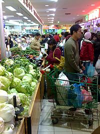
2006 census, Springvale had a generally lower-income population of 18,430, not including visitors, with production, trades, transport, manufacturing and labouring being the dominant occupations. The largest representation of people with a place of birth outside Australia is Vietnam. Ethnic Vietnamese make up 21.3% of the population. Additionally significant Chinese, Cambodian, Greek and Indian communities exist. The region is rich in history and thrives on a harmonious mix of working class and multicultural families. The rapid increase in the Asian population in recent years has meant that Springvale and its surrounds are now one of Victoria’s strongest Vietnamese areas. It is not uncommon for shops in Springvale to contain no English writing.
The most common religions were Buddhism (29%) and Catholicism (24.1%), with sizable minorities identifying as Eastern Orthodox or Anglican.
.
Springvale plays host to Springvale White Eagles
in the Victorian Premier League
which is the highest division in football (soccer) in Victoria
.
 Springvale Neighbourhood House was established in 1983 with the aim of providing a resource centre for self-help, social, cultural and action groups. Over 40 self help groups meet at the house, including ESL, Computer and Horticulture classes and celebrations such as Refugee Week, Sumnation and Adult Learners Week.
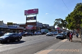
 Springvale is usually very crowded, especially during the weekends. Efforts to reduce the crowding have included the creation of parking garages.
at both federal and state elections
. At federal level the suburb is divided between the federal divisions of Hotham
, currently held by Simon Crean
, and Bruce
. Of the five booths in the suburb (Whiteside, Sandown Park, Heatherhill, Springvale and Springvale West) the lowest two-party-preferred result for Labor at the 2004 federal election was 69.82% (Whiteside), while the highest was 76.52% (Springvale West).
At state level, Springvale is split between the electorates of Clayton
, Lyndhurst
and Mulgrave
. At local level, Springvale is divided between the Springvale Central and Springvale North wards of the City of Greater Dandenong
, represented respectively by Youhorn Chea (a councillor since 1997) and Alan Gordon.
. Both are located on the Pakenham and Cranbourne railway lines. Several bus routes also run through the suburb including Smart Bus Route 902 to Airport West Shopping Centre and Chelsea Railway Station.
Secondary schools:
Sandown International Motor Raceway
incorporates a motor racing track with permanent pit and grandstand facilities. It is accessible from the Princes Highway and via Sandown Park
railway station. The Sandown Racecourse
is co-located with the motor raceway, and is one of the four horse racing venues in Melbourne. On the other (southwestern) side of the railway is Sandown Park Greyhound Racing Track.
Melbourne
Melbourne is the capital and most populous city in the state of Victoria, and the second most populous city in Australia. The Melbourne City Centre is the hub of the greater metropolitan area and the Census statistical division—of which "Melbourne" is the common name. As of June 2009, the greater...
, Victoria
Victoria (Australia)
Victoria is the second most populous state in Australia. Geographically the smallest mainland state, Victoria is bordered by New South Wales, South Australia, and Tasmania on Boundary Islet to the north, west and south respectively....
, Australia
Australia
Australia , officially the Commonwealth of Australia, is a country in the Southern Hemisphere comprising the mainland of the Australian continent, the island of Tasmania, and numerous smaller islands in the Indian and Pacific Oceans. It is the world's sixth-largest country by total area...
, approximately 20 km south-east from Melbourne's central business district
Melbourne city centre
Melbourne City Centre is an area of Melbourne in Victoria, Australia. It is not to be confused with the larger local government area of the City of Melbourne...
. Its Local Government Area is the City of Greater Dandenong
City of Greater Dandenong
The City of Greater Dandenong is a Local Government Area in Victoria, Australia located in the southeastern suburbs of Melbourne. It has an area of 130 square kilometres and has a estimated population of 137,600 people....
. At the 2006 Census, Springvale had a population of 18,430.
Springvale is a large suburb occupying 11.2 km², bounded by Westall Road
Westall Road
Westall Road is a major north to south thoroughfare west of Springvale, Victoria, Australia.Starting at the intersection with Princes Highway in Clayton, the road travels in a southerly direction, intersecting with Centre Road, an overpass of the Cranbourne and Pakenham railway lines and an...
Monash Freeway
Monash Freeway is an urban freeway in Victoria, Australia linking Melbourne's CBD to its southeastern suburbs and the Gippsland region. The entire stretch of the Monash Freeway bears the designation...
via the Ferntree Gully Road exit to the suburb's northwest.
History
The municipal area of Springvale was originally part of the Dandenong shire and is at the doorstep of the Dandenong RangesDandenong Ranges
The Dandenong Ranges are a set of low mountain ranges, rising to 633 metres at Mount Dandenong, approximately 35 km east of Melbourne, Victoria, Australia...
National Park, one of the scenic and recreational gems of Greater Melbourne. The area contained natural springs which were a permanent water source for stock and travellers moving between Melbourne and Dandenong
Dandenong, Victoria
Dandenong is a suburb and major urban centre in metropolitan Melbourne, Victoria, Australia, 30 km south-east from Melbourne's central business district. Situated on Dandenong Creek and mostly flat land at the foothills of Mount Dandenong, it is the main administrative centre for the City of...
, giving rise to the suburb's name. In the 1850s, a Spring Vale Hotel was built near a newly-surveyed route between Oakleigh
Oakleigh, Victoria
Oakleigh is a suburb of Melbourne, Victoria, Australia and is located 14 km south-east from Melbourne's central business district. Its Local Government Area is the City of Monash. At the 2006 Census, Oakleigh had a population of 6,876....
and Dandenong at what is now the intersection of Princes Highway
Princes Highway
The Princes Highway extends from Sydney to Port Augusta via the coast through the states of New South Wales, Victoria and South Australia, a distance of 1941 km or 1898 km via the former alignments of the highway ....
and Springvale Road. However, it did not develop into a settlement.
The first Springvale Post Office opened on 12 September 1864 and closed in 1892. This office had been superseded by Springvale Railway Station office (opened 1887) which was renamed Springvale in 1902. A Springvale North Post Office was also open between 1946 and 1978.
In 1886, land was subdivided near the railway station and the area began to grow. By the 1920s the Spring Vale community had a lodge, brass band, a recreation reserve, a mechanics' institute, a few shops and some houses in the township. A picture theatre opened in 1924. At the outbreak of the second world war
World War II
World War II, or the Second World War , was a global conflict lasting from 1939 to 1945, involving most of the world's nations—including all of the great powers—eventually forming two opposing military alliances: the Allies and the Axis...
Springvale was a pastoral, residential and industrial township with market gardens in the surrounding areas. Sand extraction industries were active, lasting until the 1990s.
The clearest indication of postwar residential growth occurred in the early 1960s when Rockman's Shopwell department store was built, and later when shops on the east side of Springvale Road were removed for road widening. Housing growth was rapid and estates with made roads and services replaced unserviced subdivisions. The new Sandown racecourse site was opened in 1961 for both horse and motor-car racing.
Today
On the north of the Princes Highway is the Springvale Crematorium and Necropolis. Next to the Crematorium is an area of housing and the original Springvale primary school near where Centre and Springvale Roads cross Princes Highway.The suburb is mostly residential, although some small industrial areas are scattered through the suburb's northwest and northeast. Eastern Springvale contains Springvale Crematorium and Necropolis
Necropolis
A necropolis is a large cemetery or burial ground, usually including structural tombs. The word comes from the Greek νεκρόπολις - nekropolis, literally meaning "city of the dead"...
, one of Melbourne's three main cemeteries, and the Sandown motor raceway.
Springvale hosts a multitude of different nationalities, has a prominent Vietnamese
Vietnamese people
The Vietnamese people are an ethnic group originating from present-day northern Vietnam and southern China. They are the majority ethnic group of Vietnam, comprising 86% of the population as of the 1999 census, and are officially known as Kinh to distinguish them from other ethnic groups in Vietnam...
presence and is the former site of a migrant hostel. Springvale was once a city in its own right, but a local government boundary reshuffle in December 1994, saw part of the municipality amalgamated into the City of Greater Dandenong
City of Greater Dandenong
The City of Greater Dandenong is a Local Government Area in Victoria, Australia located in the southeastern suburbs of Melbourne. It has an area of 130 square kilometres and has a estimated population of 137,600 people....
and the rest merged into the new City of Kingston
City of Kingston
The City of Kingston is a Local Government Area in Victoria, Australia. It is located in the south-eastern suburbs of Melbourne, its northern boundary lying approximately 15 km from the Melbourne city centre along the north-eastern shorelines of Port Phillip...
.
Springvale remains home to the Sandown Racecourse
Sandown Racecourse
Sandown Racecourse is one of the four horse racing venues located in Melbourne, Victoria, Australia. Built for the Victoria Amateur Turf Club, it is the only metropolitan racecourse built in the 20th century and was opened before a crowd of 52,000, in June 1965.Sandown Racecourse is situated 25...
, and is also known throughout Australian revhead circles as the home of the Sandown International Motor Raceway
Sandown Raceway
Sandown International Raceway is a motor racing circuit in Melbourne, Victoria, approximately south east of the city centre. It is considered a power circuit with its front straight being 899m long and back straight 910m long.-History:...
which hosts a number of major car races every year including the Sandown 500
Sandown 500
The Sandown 500 is an endurance motor race staged at the Sandown Raceway, near Melbourne in Victoria, Australia between 1964 and 2011. It was typically held in September, the month before Australia’s premier endurance race, the Bathurst 1000. The “500” was not run in 1966, 1967, 1999, 2000, 2008,...
and the V8 Ultimate, a key event in the V8 Supercar
V8 Supercar
V8 Supercars is a touring car racing category based in Australia and run as an International Series under Fédération Internationale de l'Automobile regulations...
series.
Demographics
At the Australian Bureau of StatisticsAustralian Bureau of Statistics
The Australian Bureau of Statistics is Australia's national statistical agency. It was created as the Commonwealth Bureau of Census and Statistics on 8 December 1905, when the Census and Statistics Act 1905 was given Royal assent. It had its beginnings in section 51 of the Constitution of Australia...
2006 census, Springvale had a generally lower-income population of 18,430, not including visitors, with production, trades, transport, manufacturing and labouring being the dominant occupations. The largest representation of people with a place of birth outside Australia is Vietnam. Ethnic Vietnamese make up 21.3% of the population. Additionally significant Chinese, Cambodian, Greek and Indian communities exist. The region is rich in history and thrives on a harmonious mix of working class and multicultural families. The rapid increase in the Asian population in recent years has meant that Springvale and its surrounds are now one of Victoria’s strongest Vietnamese areas. It is not uncommon for shops in Springvale to contain no English writing.
The most common religions were Buddhism (29%) and Catholicism (24.1%), with sizable minorities identifying as Eastern Orthodox or Anglican.
Sport
The suburb has an Australian Rules football team, Springvale District Football Club, competing in the Southern Football LeagueSouthern Football League (Victoria)
The Southern Football League is an Australian rules football league, based in the south and south eastern suburbs of Melbourne, Victoria, for both seniors and juniors....
.
Springvale plays host to Springvale White Eagles
Springvale White Eagles
Springvale White Eagles Soccer Club is an Australian association football club based in Melbourne, Victoria currently playing in Victorian State League Division 1...
in the Victorian Premier League
Victorian Premier League
The Victorian Premier League is the highest State level association football competition in Victoria, Australia, and second highest nationally after the A-League...
which is the highest division in football (soccer) in Victoria
Victoria (Australia)
Victoria is the second most populous state in Australia. Geographically the smallest mainland state, Victoria is bordered by New South Wales, South Australia, and Tasmania on Boundary Islet to the north, west and south respectively....
.
Facilities
Crowding
Politics
Springvale is very safe for the Australian Labor PartyAustralian Labor Party
The Australian Labor Party is an Australian political party. It has been the governing party of the Commonwealth of Australia since the 2007 federal election. Julia Gillard is the party's federal parliamentary leader and Prime Minister of Australia...
at both federal and state elections
Victorian Legislative Assembly
The Victorian Legislative Assembly is the lower house of the Parliament of Victoria in Australia. Together with the Victorian Legislative Council, the upper house, it sits in Parliament House in the state capital, Melbourne.-History:...
. At federal level the suburb is divided between the federal divisions of Hotham
Division of Hotham
The Division of Hotham is an Australian Electoral Division in Victoria. The division was created in 1969 and is named for Sir Charles Hotham, Governor of Victoria 1854-55. It is located in the south-eastern suburbs of Melbourne. Hotham covers an area of approximately 72 square kilometres from...
, currently held by Simon Crean
Simon Crean
Simon Findlay Crean is an Australian politician, and the current Minister for the Arts and Minister for Regional Australia, Regional Development and Local Government in the Australian Federal Government. He was leader of the Australian Labor Party and Leader of the Opposition at the Federal level,...
, and Bruce
Division of Bruce
The Division of Bruce is an Australian Electoral Division in Victoria. The division was created in 1955 and is named for Stanley Bruce, who was Prime Minister of Australia from 1923 to 1929. It is located in the eastern suburbs of Melbourne...
. Of the five booths in the suburb (Whiteside, Sandown Park, Heatherhill, Springvale and Springvale West) the lowest two-party-preferred result for Labor at the 2004 federal election was 69.82% (Whiteside), while the highest was 76.52% (Springvale West).
At state level, Springvale is split between the electorates of Clayton
Electoral district of Clayton
The Electoral district of Clayton is an electoral district of the Victorian Legislative Assembly. It is based around the Melbourne suburb of Clayton after which it is named, and it also includes Clarinda, Notting Hill as well as parts of surrounding suburbs....
, Lyndhurst
Electoral district of Lyndhurst
The Electoral district of Lyndhurst is an electorate of the Victorian Legislative Assembly and is located in the south eastern suburbs of Melbourne. Included within its boundaries are Bangholme and Lyndhurst and parts of other surrounding suburbs, such as Noble Park and Springvale.The seat was...
and Mulgrave
Electoral district of Mulgrave (Victoria)
The Electoral district of Mulgrave is situated in the South-East of the Melbourne Metropolitan Region. The Electorate contains the suburbs of Mulgrave and Noble Park North. It also conatins parts of the suburbs of Dandernong North, Noble Park, Springvale and Wheelers Hill...
. At local level, Springvale is divided between the Springvale Central and Springvale North wards of the City of Greater Dandenong
City of Greater Dandenong
The City of Greater Dandenong is a Local Government Area in Victoria, Australia located in the southeastern suburbs of Melbourne. It has an area of 130 square kilometres and has a estimated population of 137,600 people....
, represented respectively by Youhorn Chea (a councillor since 1997) and Alan Gordon.
Transport
Springvale has two railway stations: Springvale and Sandown ParkSandown Park railway station, Melbourne
Sandown Park is a railway station in Melbourne, Victoria, Australia, located in the suburb of Springvale, on the Pakenham and Cranbourne railway lines. Sandown Park is unmanned and is in Metcard Zone 2.-Facilities:...
. Both are located on the Pakenham and Cranbourne railway lines. Several bus routes also run through the suburb including Smart Bus Route 902 to Airport West Shopping Centre and Chelsea Railway Station.
Education
Primary schools:- Heatherhill Primary School
- Springvale Rise Primary School, Springvale campus
- Springvale Rise Primary School, Springvale Heights campus
- Spring Parks Primary School, Valley Campus
- Spring Parks Primary School, West Campus
- St. Joseph's School
Secondary schools:
- Minaret CollegeMinaret CollegeMinaret College is the largest co-educational Islamic school in South-Eastern Melbourne, Australia. Established in 1992 with only 22 students, the college now has approximately 1200 students from Prep to Year 12....
, Springvale campus - Killester CollegeKillester CollegeKillester College is a Roman Catholic girls secondary college in Springvale, Victoria, Australia. Killester works under the governance of the Brigidine Sisters...
Landmarks and notable places
The Necropolis, Springvale is the largest facility of its kind in Melbourne.Sandown International Motor Raceway
Sandown Raceway
Sandown International Raceway is a motor racing circuit in Melbourne, Victoria, approximately south east of the city centre. It is considered a power circuit with its front straight being 899m long and back straight 910m long.-History:...
incorporates a motor racing track with permanent pit and grandstand facilities. It is accessible from the Princes Highway and via Sandown Park
Sandown Park railway station, Melbourne
Sandown Park is a railway station in Melbourne, Victoria, Australia, located in the suburb of Springvale, on the Pakenham and Cranbourne railway lines. Sandown Park is unmanned and is in Metcard Zone 2.-Facilities:...
railway station. The Sandown Racecourse
Sandown Racecourse
Sandown Racecourse is one of the four horse racing venues located in Melbourne, Victoria, Australia. Built for the Victoria Amateur Turf Club, it is the only metropolitan racecourse built in the 20th century and was opened before a crowd of 52,000, in June 1965.Sandown Racecourse is situated 25...
is co-located with the motor raceway, and is one of the four horse racing venues in Melbourne. On the other (southwestern) side of the railway is Sandown Park Greyhound Racing Track.
External links
- Australian Places - Springvale
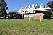
- Springvale Community Centre - Springvale Community Centre
- Springvale Neighbourhood House
- Springvale on Google Maps