
Mid-May 2008 tornado outbreak sequence
Encyclopedia
The Mid-May 2008 tornado outbreak sequence is a series of tornado outbreak
s that affected the Southern Plains, the southeastern and Middle Atlantic region of the United States
. The storm has produced 147 confirmed tornadoes starting on May 7 and lasting until late on May 15. The outbreak sequence killed 28 people across several states (25 from tornadoes). The event occurred less than a week after a deadly tornado outbreak that principally affected the state of Arkansas
and killed 7 people.
 The event started in Oklahoma on May 7 as an initial low pressure crossed the southern Plains and produced tornadoes across the Oklahoma City
area producing scattered damage throughout the Metro Area including in Yukon
, Bethany
, Warr Acres
and north Oklahoma City. KOCO-TV
recorded a 124 miles per hour (200 km/h) wind gust while Chief Meteorologist Rick Mitchell was reporting on the storm. Widespread tree, fence, and minor property damage was reported throughout much of the area while there was also a gas leak reported in Bethany. Tree damage was also reported just outside the KFOR
and KOCO stations. Similar conditions occurred south and east of Tulsa, Oklahoma
as the line of thunderstorms raced across the state and caused similar damage although a portions of a storage structure was destroyed by the force of the winds. At least five tornadoes were confirmed throughout the state but all were rated either EF0 or EF1. There were no reports of injuries during the event.
Two significant tornado outbreaks affected the southeastern United States on May 8. During the morning hours, tornadoes touched down across northeastern Mississippi including one EF3 in the Tupelo, Mississippi
area which heavily damaged several buildings near the Tupelo Airport. Tornadoes also touched down across northwestern Alabama north and west of Birmingham
and Huntsville
. One particular tornado was caught on tape by a security camera at a business near Leighton
in Colbert County
which overturned cars at a parking lot. Another tornado crossed very near the ABC 33-40
Sky Cam in Cullman
but the tornado was not seen as very strong winds stopped the video data prior to its passage. Structural damage was also reported to homes across the area.
While weak tornadoes touched down north of Xenia, Ohio
during the early evening hours, the second outbreak of the day produced several strong tornadoes across the western Carolinas and southwestern Virginia. A line of showers and thunderstorms moved across the Appalachians. CAPE values were at around 1500 j/kg across parts of North Carolina. One tornado hit the Clemmons, North Carolina
area producing EF3 damage to several homes. The same area was hit an F3 tornado on the same date in 1998. Just after 11:00 pm, another tornado from the same supercell
struck the western Greensboro
region, killing one person inside a truck overturned by the tornado. The storm also damaged several buildings including homes, businesses and warehouses. Two Fed-Fex planes at the Piedmont Triad International Airport
were pitched off the tarmac as the storm lifted near the area. Other tornadoes produced some significant damage north of the Piedmont Triad
region across southern Virginia.
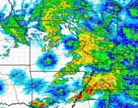
 On May 10, a new wave of tornadoes from a second system affected portions of the southern Plains and the Lower-Mississippi Valley. Temperatures across the region reached the 80s across portions of the South with mostly upper 70s elsewhere. CAPE
values were between 1000 and 2000 j/kg near the center of the low with reading over 2000 j/kg across Mississippi. Helicity levels were over 250. A moderate risk of severe storms was issued for a large portions of the Mississippi Valley as well as the Eastern Plains. Severe storms began to occur across northwestern Arkansas, southeastern Kansas and eastern Oklahoma during the late afternoon hours. Tornado watches extended from eastern Oklahoma to South Carolina and north to near Kansas City.
One violent EF4 tornado killed 15 people in Missouri
and six people in northeastern Oklahoma, with one other death from an EF1 tornado also in Missouri. Moderate to major damage was reported across Ottawa County, Oklahoma
and Newton County, Missouri as well as in Stuttgart, Arkansas
and near McAlester, Oklahoma
where a tornado was caught on tape by a television crew from a helicopter. Other tornadoes were reported across Missouri
, Oklahoma
, Arkansas
and Kansas
. In the late evening, after crossing the Mississippi River
, the supercells combined into a bow echo
/derecho
that tracked from the Memphis
Metropolitan Area then across northern Mississippi
, Alabama
, Georgia
and South Carolina
, with widespread wind damage and embedded tornadoes. Two people were killed in Laurens County, Georgia
and at least 85,000 customers were left without power in the Atlanta metropolitan area.
 Additional tornadoes touched down across the southeast and the eastern Ohio Valley from central Ohio to North Carolina but the bulk of the activity took place across central and southern Georgia where nearly 20 tornadoes were confirmed in that state alone. One tornado went through the city of Macon, Georgia
, causing extensive damage to some buildings at Macon State College
. This forced the closure of the Macon campus for repair. A violent EF4 was also confirmed near Darien
in McIntosh County
where numerous buildings near Interstate 95
were heavily damaged or destroyed. This was the first violent tornado in Georgia since an F4 hit four counties north of Atlanta on March 27, 1994. The tornado that occurred during the Palm Sunday tornado outbreak of 1994 killed three and injured 20 over a nearly 50-mile path. Georgia Governor Sonny Purdue declared a state of emergency for at least six counties across the state. In addition to the tornado fatalities, one person was killed due to straight line winds in Barrow County, Georgia
.
A third albeit smaller outbreak affected the Deep South on May 14–15. On May 14, several weak tornadoes touched down across western and central Texas causing minor damage. On May 15, severe thunderstorms with damaging winds and tornadoes went through the Gulf South. In Grosse Tete, Louisiana
. Winds from a thunderstorm knocked down a tree onto a camper, killing a man inside. In Burnet County, an EF0 tornado caused significant tree damage along with minor damage to a mobile home.
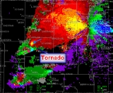
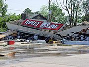
 The deadliest tornadoes and most notable tornado of the outbreak took place from a single supercell that tracked through Ottawa County, Oklahoma
, Newton County, Missouri and Barry County, Missouri
in the late afternoon of May 10. 21 people were killed in the tornado - fatalities took place in Picher, Oklahoma
(where 6 people were killed), and Newton and Barry counties in Missouri (where 15 people were killed). One other person was killed in Jasper County, Missouri from an EF1 tornado. Eight of the victims died inside their cars, troubling experts who say the inside of a vehicle is one of the worst places to be during a tornado. This was the second deadliest tornado of the year behind the EF3 tornado that affected areas northeast of Nashville, Tennessee
on February 5, 2008
and killed 22.
The tornado first touched down near the Kansas
-Oklahoma
border in Oklahoma southwest of Chetopa, Kansas
and tracked eastward. It then slammed into Picher with devastating results. 20 blocks of the town suffered extensive damage with houses and businesses destroyed or flattened. The damage in Picher was rated at EF4. At least 150 others were injured in Picher alone. The tornado continued eastward, passing just north of Quapaw
and Peoria
before crossing Interstate 44
into Missouri. This was the deadliest tornado in Oklahoma since the South Oklahoma City F5 tornado on May 3, 1999 which killed 36.
Most of the fatalities in Missouri were reported near the Racine
community at the intersection of Route 43 and Iris Road, northwest of Neosho, where automobiles were thrown as far as 1/2 mile (800 m) away. Nearly 20 people were hospitalized in Newton County. It was the deadliest single tornado in Missouri since a tornado hit the St. Louis Metro area on February 10, 1959
killing 21 and the deadliest outbreak for that state since May 4, 2003
where 19 were killed.
The Tornado continued eastward toward Granby, MO. It passed very close to the intersection of US 60 and Route 59 aboout 3 miles west of Granby, destroying a church building and numerous homes/buildings as it passed through. The Tornado continued southeastward and crossed Route B about 1 mile south of Granby. The area surrounding Granby's cemetery and rodeo grounds took heavy damage. The tornado continued eastward toward the village of Newtonia. There were no reported storm related deaths in the area surrounding Granby, MO.
Preliminary information from the National Weather Service
office in Springfield, Missouri
suggest the Newton County tornado was a violent tornado. The preliminary rating was EF3 but it was later upgraded to an EF4 according to a later survey. The tornado continued into Barry County, where one person was killed in Purdy
. In Barry County, several buildings were damaged including numerous houses, a church, four mobile homes and many outbuildings. The tornado lifted just southeast of McDowell. Debris from the storm such as letters, bills and foam traveled as far east as the Springfield
area about 80 miles (130 km) to the east of the hardest hit region in southwestern Missouri.
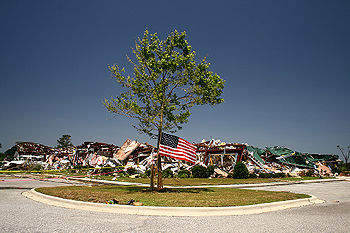
Oklahoma Governor
Brad Henry
sent National Guard Troops as well as emergency personnel to assist the hardest hit area in Picher
where a 20-block area suffered major damage including several destroyed structures. Damage was reported in Peoria
and Quapaw
. Governor Henry and as well as US Homeland Security Secretary Michael Chertoff
visited the tornado-ravaged area in the following days. Chertoff told that "it looks like a small nuclear bomb went off. Federal and state officials confirmed there would be no funding for rebuilding the town. Governor Henry did however requested a federal disaster declaration for storm victims. Before the tornado hit the town, the government had planned to buy-out homes in the area which was the site of a large zinc mine.
Tornado outbreak
While there is no single agreed upon definition, generally at least 6-10 tornadoes produced by the same synoptic scale weather system is considered a tornado outbreak. The tornadoes usually occur within the same day, or continue into the early morning hours of the succeeding day, and within the...
s that affected the Southern Plains, the southeastern and Middle Atlantic region of the United States
United States
The United States of America is a federal constitutional republic comprising fifty states and a federal district...
. The storm has produced 147 confirmed tornadoes starting on May 7 and lasting until late on May 15. The outbreak sequence killed 28 people across several states (25 from tornadoes). The event occurred less than a week after a deadly tornado outbreak that principally affected the state of Arkansas
Arkansas
Arkansas is a state located in the southern region of the United States. Its name is an Algonquian name of the Quapaw Indians. Arkansas shares borders with six states , and its eastern border is largely defined by the Mississippi River...
and killed 7 people.
Meteorological synopsis
Oklahoma city
Oklahoma City is the capital and largest city of the U.S. state of Oklahoma.Oklahoma City may also refer to:*Oklahoma City metropolitan area*Downtown Oklahoma City*Uptown Oklahoma City*Oklahoma City bombing*Oklahoma City National Memorial...
area producing scattered damage throughout the Metro Area including in Yukon
Yukon, Oklahoma
Yukon is a city in Canadian County, Oklahoma, United States and is part of the Oklahoma City Metropolitan Area. The population was 22,709 at the 2010 census....
, Bethany
Bethany, Oklahoma
Bethany is a city in Oklahoma County, Oklahoma, United States, and a part of the Oklahoma City metropolitan area. The population was 20,307 at the 2000 census.-Geography:Bethany is located at ....
, Warr Acres
Warr Acres, Oklahoma
Warr Acres is a city in Oklahoma County, Oklahoma, United States, and a part of the Oklahoma City metropolitan area. It was established after World War II by C.B. Warr, a dynamic businessman, builder, and commercial developer. The population was 9,735 at the 2000 census.-History:The Warr Acres...
and north Oklahoma City. KOCO-TV
KOCO-TV
KOCO-TV, virtual channel 5 , is the ABC affiliate in the Oklahoma City television market. The station is owned by Hearst Television, Inc., but uses "Ohio/Oklahoma Hearst Television, Inc." as their end tag during their newscasts, the same licensing purpose corporation as sister Cincinnati, Ohio...
recorded a 124 miles per hour (200 km/h) wind gust while Chief Meteorologist Rick Mitchell was reporting on the storm. Widespread tree, fence, and minor property damage was reported throughout much of the area while there was also a gas leak reported in Bethany. Tree damage was also reported just outside the KFOR
KFOR-TV
KFOR-TV, virtual channel 4 , is the NBC-affiliated television station in Oklahoma City, Oklahoma. KFOR-TV is owned by Local TV, a subsidiary of the private equity group Oak Hill Capital Partners, in a duopoly with MyNetworkTV affiliate KAUT-TV ; its studios are located at 444 East Britton Road in...
and KOCO stations. Similar conditions occurred south and east of Tulsa, Oklahoma
Tulsa, Oklahoma
Tulsa is the second-largest city in the state of Oklahoma and 46th-largest city in the United States. With a population of 391,906 as of the 2010 census, it is the principal municipality of the Tulsa Metropolitan Area, a region with 937,478 residents in the MSA and 988,454 in the CSA. Tulsa's...
as the line of thunderstorms raced across the state and caused similar damage although a portions of a storage structure was destroyed by the force of the winds. At least five tornadoes were confirmed throughout the state but all were rated either EF0 or EF1. There were no reports of injuries during the event.
Two significant tornado outbreaks affected the southeastern United States on May 8. During the morning hours, tornadoes touched down across northeastern Mississippi including one EF3 in the Tupelo, Mississippi
Tupelo, Mississippi
Tupelo is the largest city in and the county seat of Lee County, Mississippi, United States. It is the seventh largest city in the state of Mississippi, smaller than Meridian, and larger than Greenville. As of the 2000 United States Census, the city's population was 34,211...
area which heavily damaged several buildings near the Tupelo Airport. Tornadoes also touched down across northwestern Alabama north and west of Birmingham
Birmingham, Alabama
Birmingham is the largest city in Alabama. The city is the county seat of Jefferson County. According to the 2010 United States Census, Birmingham had a population of 212,237. The Birmingham-Hoover Metropolitan Area, in estimate by the U.S...
and Huntsville
Huntsville, Alabama
Huntsville is a city located primarily in Madison County in the central part of the far northern region of the U.S. state of Alabama. Huntsville is the county seat of Madison County. The city extends west into neighboring Limestone County. Huntsville's population was 180,105 as of the 2010 Census....
. One particular tornado was caught on tape by a security camera at a business near Leighton
Leighton, Alabama
Leighton is a town in Colbert County, Alabama, United States. It is part of the Florence - Muscle Shoals Metropolitan Statistical Area known as "The Shoals". At the 2000 census the population was 849...
in Colbert County
Colbert County, Alabama
Colbert County is a county of the U.S. state of Alabama. Its name is in honor of brothers George and Levi Colbert, Chickasaw Indian chiefs. George Colbert operated a ferry across the Tennessee River in 1790 near present day Cherokee....
which overturned cars at a parking lot. Another tornado crossed very near the ABC 33-40
WBMA-LP
WBMA-LD, channel 58, is the ABC television affiliate for Birmingham and central Alabama. Its transmitter is located in Birmingham, while its studio is in Hoover, a suburb of Birmingham....
Sky Cam in Cullman
Cullman, Alabama
Cullman is a city in Cullman County, State of Alabama. Cullman is located along Interstate 65, about north of Birmingham, and about south of Huntsville. According to the U.S...
but the tornado was not seen as very strong winds stopped the video data prior to its passage. Structural damage was also reported to homes across the area.
While weak tornadoes touched down north of Xenia, Ohio
Xenia, Ohio
Xenia is a city in and the county seat of Greene County, Ohio, United States. The municipality is located in southwestern Ohio 21 miles from Dayton and is part of the Dayton Metropolitan Statistical Area...
during the early evening hours, the second outbreak of the day produced several strong tornadoes across the western Carolinas and southwestern Virginia. A line of showers and thunderstorms moved across the Appalachians. CAPE values were at around 1500 j/kg across parts of North Carolina. One tornado hit the Clemmons, North Carolina
Clemmons, North Carolina
Clemmons is a village in Forsyth County, North Carolina and a suburb of Winston-Salem. The population was 18,627 at the 2010 census.-Geography:Clemmons is located at ....
area producing EF3 damage to several homes. The same area was hit an F3 tornado on the same date in 1998. Just after 11:00 pm, another tornado from the same supercell
Supercell
A supercell is a thunderstorm that is characterized by the presence of a mesocyclone: a deep, continuously-rotating updraft. For this reason, these storms are sometimes referred to as rotating thunderstorms...
struck the western Greensboro
Greensboro, North Carolina
Greensboro is a city in the U.S. state of North Carolina. It is the third-largest city by population in North Carolina and the largest city in Guilford County and the surrounding Piedmont Triad metropolitan region. According to the 2010 U.S...
region, killing one person inside a truck overturned by the tornado. The storm also damaged several buildings including homes, businesses and warehouses. Two Fed-Fex planes at the Piedmont Triad International Airport
Piedmont Triad International Airport
Piedmont Triad International Airport is an airport just west of Greensboro, serving Greensboro, High Point and Winston-Salem as well as the entire Piedmont Triad Region in North Carolina. The airport has 3 runways; the third opened January 27, 2010 for traffic. The airport is located just off...
were pitched off the tarmac as the storm lifted near the area. Other tornadoes produced some significant damage north of the Piedmont Triad
Piedmont Triad
The Piedmont Triad, or Triad, is a north-central region of the U.S. state of North Carolina that consists of the area within and surrounding the three major cities of Greensboro, Winston-Salem, and High Point. This close group or "triad" of cities lies in the Piedmont geographical region of the...
region across southern Virginia.
Convective available potential energy
In meteorology, convective available potential energy , sometimes, simply, available potential energy , is the amount of energy a parcel of air would have if lifted a certain distance vertically through the atmosphere...
values were between 1000 and 2000 j/kg near the center of the low with reading over 2000 j/kg across Mississippi. Helicity levels were over 250. A moderate risk of severe storms was issued for a large portions of the Mississippi Valley as well as the Eastern Plains. Severe storms began to occur across northwestern Arkansas, southeastern Kansas and eastern Oklahoma during the late afternoon hours. Tornado watches extended from eastern Oklahoma to South Carolina and north to near Kansas City.
One violent EF4 tornado killed 15 people in Missouri
Missouri
Missouri is a US state located in the Midwestern United States, bordered by Iowa, Illinois, Kentucky, Tennessee, Arkansas, Oklahoma, Kansas and Nebraska. With a 2010 population of 5,988,927, Missouri is the 18th most populous state in the nation and the fifth most populous in the Midwest. It...
and six people in northeastern Oklahoma, with one other death from an EF1 tornado also in Missouri. Moderate to major damage was reported across Ottawa County, Oklahoma
Ottawa County, Oklahoma
Ottawa County is a county located in the U.S. state of Oklahoma. As of 2000, the population was 33,194. Its county seat is Miami. It was named for the Ottawa Tribe of Oklahoma.Ottawa County was established in 1907.-Geography:...
and Newton County, Missouri as well as in Stuttgart, Arkansas
Stuttgart, Arkansas
Stuttgart is a city in and the county seat of the northern district of Arkansas County, Arkansas, United States. It is located on U.S. Route 79 about miles southeast of Little Rock. According to 2006 Census Bureau estimates, the population of the city is 9,376.The town proclaims itself the "Rice...
and near McAlester, Oklahoma
McAlester, Oklahoma
McAlester is a city in Pittsburg County, Oklahoma, United States. The population was 17,783 at the 2000 census. It is the county seat of Pittsburg County. It is currently the largest city in the Choctaw Nation of Oklahoma, followed by Durant....
where a tornado was caught on tape by a television crew from a helicopter. Other tornadoes were reported across Missouri
Missouri
Missouri is a US state located in the Midwestern United States, bordered by Iowa, Illinois, Kentucky, Tennessee, Arkansas, Oklahoma, Kansas and Nebraska. With a 2010 population of 5,988,927, Missouri is the 18th most populous state in the nation and the fifth most populous in the Midwest. It...
, Oklahoma
Oklahoma
Oklahoma is a state located in the South Central region of the United States of America. With an estimated 3,751,351 residents as of the 2010 census and a land area of 68,667 square miles , Oklahoma is the 28th most populous and 20th-largest state...
, Arkansas
Arkansas
Arkansas is a state located in the southern region of the United States. Its name is an Algonquian name of the Quapaw Indians. Arkansas shares borders with six states , and its eastern border is largely defined by the Mississippi River...
and Kansas
Kansas
Kansas is a US state located in the Midwestern United States. It is named after the Kansas River which flows through it, which in turn was named after the Kansa Native American tribe, which inhabited the area. The tribe's name is often said to mean "people of the wind" or "people of the south...
. In the late evening, after crossing the Mississippi River
Mississippi River
The Mississippi River is the largest river system in North America. Flowing entirely in the United States, this river rises in western Minnesota and meanders slowly southwards for to the Mississippi River Delta at the Gulf of Mexico. With its many tributaries, the Mississippi's watershed drains...
, the supercells combined into a bow echo
Bow echo
A bow echo is a term describing the characteristic radar return from a mesoscale convective system that is shaped like an archer’s bow. These systems can produce severe straight-line winds and occasionally tornadoes, causing major damage.-Research:...
/derecho
Derecho
A derecho is a widespread and long-lived, violent convectively induced straight-line windstorm that is associated with a fast-moving band of severe thunderstorms in the form of a squall line usually taking the form of a bow echo...
that tracked from the Memphis
Memphis, Tennessee
Memphis is a city in the southwestern corner of the U.S. state of Tennessee, and the county seat of Shelby County. The city is located on the 4th Chickasaw Bluff, south of the confluence of the Wolf and Mississippi rivers....
Metropolitan Area then across northern Mississippi
Mississippi
Mississippi is a U.S. state located in the Southern United States. Jackson is the state capital and largest city. The name of the state derives from the Mississippi River, which flows along its western boundary, whose name comes from the Ojibwe word misi-ziibi...
, Alabama
Alabama
Alabama is a state located in the southeastern region of the United States. It is bordered by Tennessee to the north, Georgia to the east, Florida and the Gulf of Mexico to the south, and Mississippi to the west. Alabama ranks 30th in total land area and ranks second in the size of its inland...
, Georgia
Georgia (U.S. state)
Georgia is a state located in the southeastern United States. It was established in 1732, the last of the original Thirteen Colonies. The state is named after King George II of Great Britain. Georgia was the fourth state to ratify the United States Constitution, on January 2, 1788...
and South Carolina
South Carolina
South Carolina is a state in the Deep South of the United States that borders Georgia to the south, North Carolina to the north, and the Atlantic Ocean to the east. Originally part of the Province of Carolina, the Province of South Carolina was one of the 13 colonies that declared independence...
, with widespread wind damage and embedded tornadoes. Two people were killed in Laurens County, Georgia
Laurens County, Georgia
Laurens County is a county located in the U.S. state of Georgia. It was created on December 10, 1807. As of 2000, the population was 44,874. The 2007 Census Estimate shows a population of 47,520...
and at least 85,000 customers were left without power in the Atlanta metropolitan area.
Macon, Georgia
Macon is a city located in central Georgia, US. Founded at the fall line of the Ocmulgee River, it is part of the Macon metropolitan area, and the county seat of Bibb County. A small portion of the city extends into Jones County. Macon is the biggest city in central Georgia...
, causing extensive damage to some buildings at Macon State College
Macon State College
Macon State College, formerly Macon College and Macon Junior College, is a four-year, residential, baccalaureate degree institution of the University System of Georgia located in Macon, Georgia with a satellite campus in Warner Robins, Georgia, as well as the Robins Resident Center, located on...
. This forced the closure of the Macon campus for repair. A violent EF4 was also confirmed near Darien
Darien, Georgia
Darien is a city in McIntosh County, Georgia, United States. It lies on Georgia's coast at the mouth of the Altamaha River about 50 miles south of Savannah, and is part of the Brunswick, Georgia Metropolitan Statistical Area. The population of Darien was 1,719 at the 2000 census. The city is the...
in McIntosh County
McIntosh County, Georgia
McIntosh County is a county located in the U.S. state of Georgia. It is part of the Brunswick, Georgia, Metropolitan Statistical Area which encompasses all of McIntosh, Glynn, and Brantley counties. As of 2010, the population is 14,333. The county seat is Darien.-History:McIntosh County was split...
where numerous buildings near Interstate 95
Interstate 95
Interstate 95 is the main highway on the East Coast of the United States, running parallel to the Atlantic Ocean from Maine to Florida and serving some of the most populated urban areas in the country, including Boston, Providence, New Haven, New York City, Newark, Philadelphia, Baltimore,...
were heavily damaged or destroyed. This was the first violent tornado in Georgia since an F4 hit four counties north of Atlanta on March 27, 1994. The tornado that occurred during the Palm Sunday tornado outbreak of 1994 killed three and injured 20 over a nearly 50-mile path. Georgia Governor Sonny Purdue declared a state of emergency for at least six counties across the state. In addition to the tornado fatalities, one person was killed due to straight line winds in Barrow County, Georgia
Barrow County, Georgia
Barrow County is a county located in the U.S. state of Georgia. As of 2000, the population was 46,144. The 2007 Census Estimate placed the population at 67,139...
.
A third albeit smaller outbreak affected the Deep South on May 14–15. On May 14, several weak tornadoes touched down across western and central Texas causing minor damage. On May 15, severe thunderstorms with damaging winds and tornadoes went through the Gulf South. In Grosse Tete, Louisiana
Grosse Tete, Louisiana
Grosse Tête is a village in Iberville Parish, Louisiana, United States. The population was 670 at the 2000 census. Its name is French for "Big Head." Its local pronunciation is "gross tate."...
. Winds from a thunderstorm knocked down a tree onto a camper, killing a man inside. In Burnet County, an EF0 tornado caused significant tree damage along with minor damage to a mobile home.
Reported tornadoes
| Okla. Oklahoma Oklahoma is a state located in the South Central region of the United States of America. With an estimated 3,751,351 residents as of the 2010 census and a land area of 68,667 square miles , Oklahoma is the 28th most populous and 20th-largest state... | Miss. Mississippi Mississippi is a U.S. state located in the Southern United States. Jackson is the state capital and largest city. The name of the state derives from the Mississippi River, which flows along its western boundary, whose name comes from the Ojibwe word misi-ziibi... | Ala. Alabama Alabama is a state located in the southeastern region of the United States. It is bordered by Tennessee to the north, Georgia to the east, Florida and the Gulf of Mexico to the south, and Mississippi to the west. Alabama ranks 30th in total land area and ranks second in the size of its inland... | Tenn. Tennessee Tennessee is a U.S. state located in the Southeastern United States. It has a population of 6,346,105, making it the nation's 17th-largest state by population, and covers , making it the 36th-largest by total land area... | Oh. Ohio Ohio is a Midwestern state in the United States. The 34th largest state by area in the U.S.,it is the 7th‑most populous with over 11.5 million residents, containing several major American cities and seven metropolitan areas with populations of 500,000 or more.The state's capital is Columbus... | Va. Virginia The Commonwealth of Virginia , is a U.S. state on the Atlantic Coast of the Southern United States. Virginia is nicknamed the "Old Dominion" and sometimes the "Mother of Presidents" after the eight U.S. presidents born there... | N.C. North Carolina North Carolina is a state located in the southeastern United States. The state borders South Carolina and Georgia to the south, Tennessee to the west and Virginia to the north. North Carolina contains 100 counties. Its capital is Raleigh, and its largest city is Charlotte... | Md. Maryland Maryland is a U.S. state located in the Mid Atlantic region of the United States, bordering Virginia, West Virginia, and the District of Columbia to its south and west; Pennsylvania to its north; and Delaware to its east... | Kans. Kansas Kansas is a US state located in the Midwestern United States. It is named after the Kansas River which flows through it, which in turn was named after the Kansa Native American tribe, which inhabited the area. The tribe's name is often said to mean "people of the wind" or "people of the south... | Ark. Arkansas Arkansas is a state located in the southern region of the United States. Its name is an Algonquian name of the Quapaw Indians. Arkansas shares borders with six states , and its eastern border is largely defined by the Mississippi River... | Mo. Missouri Missouri is a US state located in the Midwestern United States, bordered by Iowa, Illinois, Kentucky, Tennessee, Arkansas, Oklahoma, Kansas and Nebraska. With a 2010 population of 5,988,927, Missouri is the 18th most populous state in the nation and the fifth most populous in the Midwest. It... | Ga. | S.C. South Carolina South Carolina is a state in the Deep South of the United States that borders Georgia to the south, North Carolina to the north, and the Atlantic Ocean to the east. Originally part of the Province of Carolina, the Province of South Carolina was one of the 13 colonies that declared independence... | Kent. Kentucky The Commonwealth of Kentucky is a state located in the East Central United States of America. As classified by the United States Census Bureau, Kentucky is a Southern state, more specifically in the East South Central region. Kentucky is one of four U.S. states constituted as a commonwealth... | Tex. Texas Texas is the second largest U.S. state by both area and population, and the largest state by area in the contiguous United States.The name, based on the Caddo word "Tejas" meaning "friends" or "allies", was applied by the Spanish to the Caddo themselves and to the region of their settlement in... | La. Louisiana Louisiana is a state located in the southern region of the United States of America. Its capital is Baton Rouge and largest city is New Orleans. Louisiana is the only state in the U.S. with political subdivisions termed parishes, which are local governments equivalent to counties... | In. Indiana Indiana is a US state, admitted to the United States as the 19th on December 11, 1816. It is located in the Midwestern United States and Great Lakes Region. With 6,483,802 residents, the state is ranked 15th in population and 16th in population density. Indiana is ranked 38th in land area and is... | Wy. Wyoming Wyoming is a state in the mountain region of the Western United States. The western two thirds of the state is covered mostly with the mountain ranges and rangelands in the foothills of the Eastern Rocky Mountains, while the eastern third of the state is high elevation prairie known as the High... | Total | |
|---|---|---|---|---|---|---|---|---|---|---|---|---|---|---|---|---|---|---|---|
| May 7 | 6 | 4 | 10 | ||||||||||||||||
| May 8 | 3 | 8 | 2 | 3 | 5 | 4 | 2 | 2 | 29 | ||||||||||
| May 9 | 1 | 1 | 2 | ||||||||||||||||
| May 10 | 13 | 2 | 7 | 3 | 10 | 3 | 38 | ||||||||||||
| May 11 | 1 | 10 | 19 | 6 | 3 | 1 | 40 | ||||||||||||
| May 13 | 1 | 1 | |||||||||||||||||
| May 14 | 12 | 12 | |||||||||||||||||
| May 15 | 2 | 2 | 1 | 10 | 15 | ||||||||||||||
| Total | 19 | 5 | 10 | 9 | 4 | 5 | 15 | 2 | 5 | 10 | 4 | 19 | 6 | 3 | 17 | 10 | 1 | 1 | 147 |
Picher/Neosho tornado
Ottawa County, Oklahoma
Ottawa County is a county located in the U.S. state of Oklahoma. As of 2000, the population was 33,194. Its county seat is Miami. It was named for the Ottawa Tribe of Oklahoma.Ottawa County was established in 1907.-Geography:...
, Newton County, Missouri and Barry County, Missouri
Barry County, Missouri
Barry County is a county located in the U.S. state of Missouri. As of 2010, the population was 35,597. Its county seat is Cassville. The county was organized in 1835 and named after William Taylor Barry from Kentucky, a United States Postmaster General....
in the late afternoon of May 10. 21 people were killed in the tornado - fatalities took place in Picher, Oklahoma
Picher, Oklahoma
Picher is a ghost town and former city in Ottawa County, Oklahoma, United States. Formerly a major national center of lead and zinc mining at the heart of the Tri-State Mining District, over a century of unrestricted subsurface excavation dangerously undermined most of Picher's town buildings and...
(where 6 people were killed), and Newton and Barry counties in Missouri (where 15 people were killed). One other person was killed in Jasper County, Missouri from an EF1 tornado. Eight of the victims died inside their cars, troubling experts who say the inside of a vehicle is one of the worst places to be during a tornado. This was the second deadliest tornado of the year behind the EF3 tornado that affected areas northeast of Nashville, Tennessee
Nashville, Tennessee
Nashville is the capital of the U.S. state of Tennessee and the county seat of Davidson County. It is located on the Cumberland River in Davidson County, in the north-central part of the state. The city is a center for the health care, publishing, banking and transportation industries, and is home...
on February 5, 2008
2008 Super Tuesday tornado outbreak
The 2008 Super Tuesday tornado outbreak was a deadly tornado outbreak which affected the Southern United States and the lower Ohio Valley on February 5 and 6, 2008. The event began on Super Tuesday, while 24 U.S. states were holding primary elections and caucuses to select the presidential...
and killed 22.
The tornado first touched down near the Kansas
Kansas
Kansas is a US state located in the Midwestern United States. It is named after the Kansas River which flows through it, which in turn was named after the Kansa Native American tribe, which inhabited the area. The tribe's name is often said to mean "people of the wind" or "people of the south...
-Oklahoma
Oklahoma
Oklahoma is a state located in the South Central region of the United States of America. With an estimated 3,751,351 residents as of the 2010 census and a land area of 68,667 square miles , Oklahoma is the 28th most populous and 20th-largest state...
border in Oklahoma southwest of Chetopa, Kansas
Chetopa, Kansas
Chetopa is a city in Labette County, Kansas, United States. The population was 1,281 at the 2000 census. Chetopa was named for Chief Chetopa, an Osage Indian chief.-Geography:Chetopa is located at...
and tracked eastward. It then slammed into Picher with devastating results. 20 blocks of the town suffered extensive damage with houses and businesses destroyed or flattened. The damage in Picher was rated at EF4. At least 150 others were injured in Picher alone. The tornado continued eastward, passing just north of Quapaw
Quapaw, Oklahoma
Quapaw is a town in Ottawa County, Oklahoma, United States. The population was 984 as of the 2000 census.-Geography:According to the United States Census Bureau, the town has a total area of , all land.-History:...
and Peoria
Peoria, Oklahoma
Peoria is a town in Ottawa County, Oklahoma, United States. The population was 141 at the 2000 census.-Geography:Peoria is located at .According to the United States Census Bureau, the town has a total area of , all of it land....
before crossing Interstate 44
Interstate 44
Interstate 44 is a major highway in the central United States. Its western terminus is in Wichita Falls, Texas at a concurrency with US 277, US 281 and US 287; its eastern terminus is at the Illinois state line on the Poplar Street Bridge over the Mississippi River in St...
into Missouri. This was the deadliest tornado in Oklahoma since the South Oklahoma City F5 tornado on May 3, 1999 which killed 36.
Most of the fatalities in Missouri were reported near the Racine
Racine, Missouri
Racine is an unincorporated community in Newton County, Missouri, United States. It is located along the Frisco RR tracks between Neosho and Seneca, Mo in Lost Creek Valley. Racine is on Route 86 about 6 miles west of Neosho and ten miles south of Joplin and about 5 miles northeast of Seneca and...
community at the intersection of Route 43 and Iris Road, northwest of Neosho, where automobiles were thrown as far as 1/2 mile (800 m) away. Nearly 20 people were hospitalized in Newton County. It was the deadliest single tornado in Missouri since a tornado hit the St. Louis Metro area on February 10, 1959
St. Louis tornado history
The St. Louis, Missouri metropolitan area has a history of tornadoes. The third deadliest tornado, and the costliest in United States history, the 1896 St. Louis – East St. Louis tornado, injured one thousand people and caused 255 fatalities in the City of St. Louis and in East St. Louis. The...
killing 21 and the deadliest outbreak for that state since May 4, 2003
May 2003 tornado outbreak sequence
The May 2003 tornado outbreak sequence in the United States was a series of tornado outbreaks that occurred from May 3 to May 11, 2003. Tornadoes began occurring over the affected area on April 30, but the most prolific continuous period was the seven day period of May 4–10...
where 19 were killed.
The Tornado continued eastward toward Granby, MO. It passed very close to the intersection of US 60 and Route 59 aboout 3 miles west of Granby, destroying a church building and numerous homes/buildings as it passed through. The Tornado continued southeastward and crossed Route B about 1 mile south of Granby. The area surrounding Granby's cemetery and rodeo grounds took heavy damage. The tornado continued eastward toward the village of Newtonia. There were no reported storm related deaths in the area surrounding Granby, MO.
Preliminary information from the National Weather Service
National Weather Service
The National Weather Service , once known as the Weather Bureau, is one of the six scientific agencies that make up the National Oceanic and Atmospheric Administration of the United States government...
office in Springfield, Missouri
Springfield, Missouri
Springfield is the third largest city in the U.S. state of Missouri and the county seat of Greene County. According to the 2010 census data, the population was 159,498, an increase of 5.2% since the 2000 census. The Springfield Metropolitan Area, population 436,712, includes the counties of...
suggest the Newton County tornado was a violent tornado. The preliminary rating was EF3 but it was later upgraded to an EF4 according to a later survey. The tornado continued into Barry County, where one person was killed in Purdy
Purdy, Missouri
Purdy is a city in Purdy Township, Barry County, Missouri, United States. The population was 1,103 at the 2000 census.-Geography:Purdy is located at ....
. In Barry County, several buildings were damaged including numerous houses, a church, four mobile homes and many outbuildings. The tornado lifted just southeast of McDowell. Debris from the storm such as letters, bills and foam traveled as far east as the Springfield
Springfield, Missouri
Springfield is the third largest city in the U.S. state of Missouri and the county seat of Greene County. According to the 2010 census data, the population was 159,498, an increase of 5.2% since the 2000 census. The Springfield Metropolitan Area, population 436,712, includes the counties of...
area about 80 miles (130 km) to the east of the hardest hit region in southwestern Missouri.
Oklahoma Governor
Governor of Oklahoma
The governor of the state of Oklahoma is the head of state for the state of Oklahoma, United States. Under the Oklahoma Constitution, the governor is also the head of government, serving as the chief executive of the Oklahoma executive branch, of the government of Oklahoma...
Brad Henry
Brad Henry
Charles Bradford "Brad" Henry was the 26th Governor of the U.S. state of Oklahoma. A member of the Democratic Party, he was elected governor in 2002...
sent National Guard Troops as well as emergency personnel to assist the hardest hit area in Picher
Picher, Oklahoma
Picher is a ghost town and former city in Ottawa County, Oklahoma, United States. Formerly a major national center of lead and zinc mining at the heart of the Tri-State Mining District, over a century of unrestricted subsurface excavation dangerously undermined most of Picher's town buildings and...
where a 20-block area suffered major damage including several destroyed structures. Damage was reported in Peoria
Peoria, Oklahoma
Peoria is a town in Ottawa County, Oklahoma, United States. The population was 141 at the 2000 census.-Geography:Peoria is located at .According to the United States Census Bureau, the town has a total area of , all of it land....
and Quapaw
Quapaw, Oklahoma
Quapaw is a town in Ottawa County, Oklahoma, United States. The population was 984 as of the 2000 census.-Geography:According to the United States Census Bureau, the town has a total area of , all land.-History:...
. Governor Henry and as well as US Homeland Security Secretary Michael Chertoff
Michael Chertoff
Michael Chertoff was the second United States Secretary of Homeland Security under President George W. Bush and co-author of the USA PATRIOT Act. He previously served as a judge on the United States Court of Appeals for the Third Circuit, as a federal prosecutor, and as assistant U.S. Attorney...
visited the tornado-ravaged area in the following days. Chertoff told that "it looks like a small nuclear bomb went off. Federal and state officials confirmed there would be no funding for rebuilding the town. Governor Henry did however requested a federal disaster declaration for storm victims. Before the tornado hit the town, the government had planned to buy-out homes in the area which was the site of a large zinc mine.
See also
- List of North American tornadoes and tornado outbreaks
- Tornadoes of 2008Tornadoes of 2008This page documents the tornadoes and tornado outbreaks that occurred in 2008, primarily in the United States. Most tornadoes form in the U.S., although some events may take place internationally, particularly in parts of neighboring southern Canada during the Northern Hemisphere's summer season....
- May 1–2, 2008 tornado outbreak
- Late-May 2008 tornado outbreak sequenceLate-May 2008 tornado outbreak sequenceThe Late May 2008 tornado outbreak sequence was a series of tornado outbreaks affecting the central plains of the United States since May 22, 2008. Over 250 tornadoes were reported across many states and two Canadian provinces from Wyoming to Ohio and from Manitoba to Texas, of which at least 235...