
California State Route 152
Encyclopedia
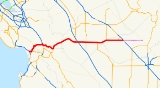
State Route 152 is a state highway
that runs near the latitudinal middle of the U.S. state
of California
from Watsonville
to Route 99
southeast of Merced
. Its western portion provides the best access to and from Interstate 5 toward southern California
for motorists in or near San Jose
.
This route is part of the California Freeway and Expressway System
and is eligible for the State Scenic Highway System
.
through Hecker Pass to reach Gilroy
where it is again carried on a series of local streets. It is then overlapped
onto to north-south U.S. Route 101 for a small stretch before it separates and returns to heading West/East again.
After exiting the large commercial developments near U.S. 101, Route 152 consists of a single lane in each direction, with narrow shoulders, rain ditches
on either side of the road, no center dividers
, and posted speed limit of 55 mph (89 km/h), making it prone to head-on collisions. Headlights are required at all times along this portion. This segment is a significant bottleneck for traffic traveling along Route 152 between the San Francisco Bay area
and the Central Valley. Upon reaching Route 156
near Hollister
, the road expands to two lanes in each direction, and climbs and curves and through the mountains of the Diablo Range
, crossing them through the Pacheco Pass
into the San Joaquin Valley
.
Route 152 continues as a four-lane divided expressway
, descending along the northern and eastern shore of the massive San Luis Reservoir
. The route passes in between the San Luis Dam
and the O'Neill Forebay. The route continues east and passes a large Path 15
substation
and then meets Interstate 5 as an expressway. It becomes a speed-limited city street Pacheco Blvd. while passing through Los Banos
before returning to an expressway until its eastern terminus at Route 99
. Here, eastbound 152 traffic merges on to southbound 99 a few miles northwest of the city of Madera
, and approximately 25 miles (40 km) northwest of Fresno
. Motorists wishing to travel north on Route 99 are advised to take Route 233
north through Chowchilla
to connect to northbound 99. Another possible northbound route exists by exiting Route 152 at State Route 59
, and proceeding directly north to the city of Merced
, where Route 59 meets Route 99.
The landmarks located on Route 152 include the Pacheco Pass
, the Gilroy Gardens
, the San Luis Reservoir
, the Casa de Fruta
and the Merry Cherries.
. The Butterfield Overland Mail
ran along this route from 1858 to 1861. A portion of Route 152 from Bell Station
to Pacheco Pass
was a toll road
from sometime in the 1840s until 1878. In that year, Merced County
and Santa Clara County
purchased the road. It was eventually upgraded to a state route. Historic references say the portion of the route west of SR33
was named Legislative Route 32 before being designated State Route 152.
{| class=wikitable
!County
!Location
!Postmile
!Destinations
!Notes
|-
|rowspan=7|Santa Cruz
SCR T0.31-8.29
|rowspan=5|Watsonville
|bgcolor=#ffdddd|T0.31
|bgcolor=#ffdddd|
|bgcolor=#ffdddd|Interchange; westbound exit and eastbound entrance
|-
|T1.20
| Green Valley Road to SR 1
south – Monterey
|
|-
|T2.50
|Freedom Boulevard – Freedom
|
|-
|T2.80-
T2.93
| West Lake Avenue, West Beach Street, Main Street to SR 129
– Monterey
|Main Street was former SR 1
south
|-
|T3.27
0.00
|Lincoln Street
|
|-
|
|R1.99
|Holohan Road, College Road – Freedom
, Santa Cruz
|
|-
|
|3.69
|Carlton Road, Casserly Road
|
|-
|rowspan=13|Santa Clara
SCL 0.00-R35.16
|
|5.03
|
|
|-
|rowspan=7|Gilroy
|7.93
|Santa Teresa Boulevard
|Serves Gavilan College
|-bgcolor=#ddffdd
|M9.43
|
|West end of US 101 Bus. overlap
|-bgcolor=#ddffdd
|M9.78
|
|East end of US 101 Bus. overlap
|-bgcolor=#ddffdd
|M10.28
R7.53Indicates that the postmile represents the distance along US 101 rather than SR 152.
|
|Interchange; west end of US 101 overlap
|-
|colspan=3 align=center|West end of freeway on US 101
|-
|colspan=3 align=center|East end of freeway on US 101
|-bgcolor=#ddffdd
|R6.08
R9.91
|
|Interchange; east end of US 101 overlap
|-
|
|12.81
|
|
|-
|
|14.89
|
|
|-
|
|
|San Felipe Road – Hollister
|
|-
|
|bgcolor=#ffdddd|R21.98
|bgcolor=#ffdddd|
|bgcolor=#ffdddd|Interchange; no westbound entrance
|-
|
|R23.41
|Casa de Fruta Parkway
|Interchange
|-
|rowspan=5|Merced
MER R0.00-R40.95
|
|bgcolor=#ddffdd|11.27
|bgcolor=#ddffdd|
|bgcolor=#ddffdd|Interchange; west end of SR 33 overlap
|-
|
|13.85
|
|Interchange
|-
|Los Banos
|21.27
|
|
|-
|
|bgcolor=#ddffdd|R32.37
|bgcolor=#ddffdd|
|bgcolor=#ddffdd|Interchange; east end of SR 33 overlap
|-
|rowspan=2|
|rowspan=2|R40.77-
R0.06
|rowspan=2|
|rowspan=2|Interchange
|-
|rowspan=6|Madera
MAD R0.00-15.63
|-
|colspan=4 align=center|West end of freeway
|-
|
|10.80
|
|
|-
|colspan=4 align=center|East end of freeway
|-
|
|
|Road 16 – Chowchilla
|
|-
|Califa
|15.63
|
|Interchange; eastbound exit and westbound entrance
State highway
State highway, state road or state route can refer to one of three related concepts, two of them related to a state or provincial government in a country that is divided into states or provinces :#A...
that runs near the latitudinal middle of the U.S. state
U.S. state
A U.S. state is any one of the 50 federated states of the United States of America that share sovereignty with the federal government. Because of this shared sovereignty, an American is a citizen both of the federal entity and of his or her state of domicile. Four states use the official title of...
of California
California
California is a state located on the West Coast of the United States. It is by far the most populous U.S. state, and the third-largest by land area...
from Watsonville
Watsonville, California
Watsonville is a city in Santa Cruz County, California, United States. The population was 51,199 according to the 2010 census.Located on the central coast of California, the economy centers predominantly around the farming industry. It is known for growing strawberries, apples, lettuce and a host...
to Route 99
California State Route 99
California State Route 99 , commonly known as Highway 99 or, simply, as 99 , is a north–south state highway in the U.S. state of California, stretching almost the entire length of the Central Valley...
southeast of Merced
Merced, California
Merced is a city in, and the county seat of, Merced County, California in the San Joaquin Valley of Northern California. As of the 2010 census, the city had a population of 78,958. Incorporated in 1889, Merced is a charter city that operates under a council-manager government...
. Its western portion provides the best access to and from Interstate 5 toward southern California
Southern California
Southern California is a megaregion, or megapolitan area, in the southern area of the U.S. state of California. Large urban areas include Greater Los Angeles and Greater San Diego. The urban area stretches along the coast from Ventura through the Southland and Inland Empire to San Diego...
for motorists in or near San Jose
San Jose, California
San Jose is the third-largest city in California, the tenth-largest in the U.S., and the county seat of Santa Clara County which is located at the southern end of San Francisco Bay...
.
This route is part of the California Freeway and Expressway System
California Freeway and Expressway System
The California Freeway and Expressway System is a system of existing or planned freeways and expressways in the U.S. state of California. It is defined by the Streets and Highways Code.-List of roads in the system:*State Route 1 *State Route 2...
and is eligible for the State Scenic Highway System
State Scenic Highway System (California)
The State Scenic Highway System is a list of highways, mainly state highways, that have been designated by the California Department of Transportation as scenic highways. The California State Legislature, primarily through Section 263 of the Streets and Highways Code, makes highways eligible for...
.
Route description
Route 152 begins near Route 1 as a series of local streets that run through downtown Watsonville, E.Lake Ave carries it till the intersection of Casserly Rd where the winding two-lane highway begins that crosses the Santa Cruz MountainsSanta Cruz Mountains
The Santa Cruz Mountains, part of the Pacific Coast Ranges, are a mountain range in central California, United States. They form a ridge along the San Francisco Peninsula, south of San Francisco, separating the Pacific Ocean from San Francisco Bay and the Santa Clara Valley, and continuing south,...
through Hecker Pass to reach Gilroy
Gilroy, California
Gilroy is the southernmost city in Santa Clara County, California, United States. The population was 48,821 at the 2010 census. Gilroy is well-known for its garlic crop and for the annual Gilroy Garlic Festival, featuring various garlicky foods, including garlic ice cream. Gilroy also produces...
where it is again carried on a series of local streets. It is then overlapped
Concurrency (road)
A concurrency, overlap, or coincidence in a road network is an instance of one physical road bearing two or more different highway, motorway, or other route numbers...
onto to north-south U.S. Route 101 for a small stretch before it separates and returns to heading West/East again.
After exiting the large commercial developments near U.S. 101, Route 152 consists of a single lane in each direction, with narrow shoulders, rain ditches
Arroyo (creek)
An arroyo , a Spanish word translated as brook, and also called a wash is usually a dry creek or stream bed—gulch that temporarily or seasonally fills and flows after sufficient rain. Wadi is a similar term in Africa. In Spain, a rambla has a similar meaning to arroyo.-Types and processes:Arroyos...
on either side of the road, no center dividers
Central reservation
On divided roads, such as divided highways or freeways/motorways, the central reservation , median, parkway , median strip or central nature strip is the area which separates opposing lanes of traffic...
, and posted speed limit of 55 mph (89 km/h), making it prone to head-on collisions. Headlights are required at all times along this portion. This segment is a significant bottleneck for traffic traveling along Route 152 between the San Francisco Bay area
San Francisco Bay Area
The San Francisco Bay Area, commonly known as the Bay Area, is a populated region that surrounds the San Francisco and San Pablo estuaries in Northern California. The region encompasses metropolitan areas of San Francisco, Oakland, and San Jose, along with smaller urban and rural areas...
and the Central Valley. Upon reaching Route 156
California State Route 156
State Route 156 is a state highway in California, USA, running from Castroville to State Route 152 near Hollister.This route is eligible for the State Scenic Highway System.-Route description:...
near Hollister
Hollister, California
Hollister is a city in and the county seat of San Benito County, California, United States. The population was 34,928 at the 2010 census. Hollister is primarily an agricultural town.-History:...
, the road expands to two lanes in each direction, and climbs and curves and through the mountains of the Diablo Range
Diablo Range
The Diablo Range is a mountain range in the California Coast Ranges subdivision of the Pacific Coast Ranges. It is located in the eastern San Francisco Bay area south to the Salinas Valley area of northern California, the United States.-Geography:...
, crossing them through the Pacheco Pass
Pacheco Pass
Pacheco Pass, elevation , is a mountain pass located in the Diablo Range in southeastern Santa Clara County, California. It is the main road over the hills separating the Santa Clara Valley and the Central Valley....
into the San Joaquin Valley
San Joaquin Valley
The San Joaquin Valley is the area of the Central Valley of California that lies south of the Sacramento – San Joaquin River Delta in Stockton...
.
Route 152 continues as a four-lane divided expressway
Limited-access road
A limited-access road known by various terms worldwide, including limited-access highway, dual-carriageway and expressway, is a highway or arterial road for high-speed traffic which has many or most characteristics of a controlled-access highway , including limited or no access to adjacent...
, descending along the northern and eastern shore of the massive San Luis Reservoir
San Luis Reservoir
The San Luis Reservoir is an off-stream artificial lake in the eastern slopes of the Diablo Range of Merced County, California, approximately west of Los Banos on State Route 152, which crosses Pacheco Pass and runs along its north shore. The reservoir stores water taken from the San...
. The route passes in between the San Luis Dam
San Luis Dam
San Luis Dam is a dam that creates San Luis Reservoir, which serves as an off-stream reservoir for the California State Water Project and the Central Valley Project. It is also known as the B.F. Sisk Dam, after Bernie Sisk. The earth-fill gravity embankment dam is 305 feet tall and was completed...
and the O'Neill Forebay. The route continues east and passes a large Path 15
Path 15
Path 15 is an portion of the north-south power transmission corridor in California, U.S. It forms a part of the Pacific AC Intertie and the California-Oregon Transmission Project....
substation
Electrical substation
A substation is a part of an electrical generation, transmission, and distribution system. Substations transform voltage from high to low, or the reverse, or perform any of several other important functions...
and then meets Interstate 5 as an expressway. It becomes a speed-limited city street Pacheco Blvd. while passing through Los Banos
Los Banos, California
Los Banos is a city in Merced County, California, near the junction of State Route 152 and Interstate 5. Los Banos is located southwest of Merced, at an elevation of 118 feet . The population was 35,972 at the 2010 census, up from 25,869 at the 2000 census...
before returning to an expressway until its eastern terminus at Route 99
California State Route 99
California State Route 99 , commonly known as Highway 99 or, simply, as 99 , is a north–south state highway in the U.S. state of California, stretching almost the entire length of the Central Valley...
. Here, eastbound 152 traffic merges on to southbound 99 a few miles northwest of the city of Madera
Madera, California
Madera is a city in and the county seat of Madera County, California, United States. It is a principal city of the Madera–Chowchilla Metropolitan Statistical Area, which encompasses all of Madera County, and Metropolitan Fresno. It is located in California's San Joaquin Valley. As of the 2010...
, and approximately 25 miles (40 km) northwest of Fresno
Fresno, California
Fresno is a city in central California, United States, the county seat of Fresno County. As of the 2010 census, the city's population was 510,365, making it the fifth largest city in California, the largest inland city in California, and the 34th largest in the nation...
. Motorists wishing to travel north on Route 99 are advised to take Route 233
California State Route 233
State Route 233 is a state highway in the U.S. state of California in Madera County. It serves as an alternate route from Route 152 to Route 99, going through the city of Chowchilla instead of bypassing it.-Route description:...
north through Chowchilla
Chowchilla, California
Chowchilla is a city in Madera County, California, United States. Chowchilla is located northwest of Madera, at an elevation of 240 feet . It is a principal city of the Madera–Chowchilla Metropolitan Statistical Area. The population was 18,720 at the 2010 census, up from 11,127 at the 2000...
to connect to northbound 99. Another possible northbound route exists by exiting Route 152 at State Route 59
California State Route 59
State Route 59 is a California state highway that connects State Route 152 to the city of Merced and beyond, ending abruptly at the intersection of County Routes J59 and J16 in Snelling.-Route description:...
, and proceeding directly north to the city of Merced
Merced, California
Merced is a city in, and the county seat of, Merced County, California in the San Joaquin Valley of Northern California. As of the 2010 census, the city had a population of 78,958. Incorporated in 1889, Merced is a charter city that operates under a council-manager government...
, where Route 59 meets Route 99.
The landmarks located on Route 152 include the Pacheco Pass
Pacheco Pass
Pacheco Pass, elevation , is a mountain pass located in the Diablo Range in southeastern Santa Clara County, California. It is the main road over the hills separating the Santa Clara Valley and the Central Valley....
, the Gilroy Gardens
Gilroy Gardens
Gilroy Gardens is a garden-themed family theme park in Gilroy, California and current location of the world-famous Circus Trees created by Axel Erlandson. It was founded by Michael and Claudia Bonfante after selling their Nob Hill Foods supermarket chain to build the park. The park was constructed...
, the San Luis Reservoir
San Luis Reservoir
The San Luis Reservoir is an off-stream artificial lake in the eastern slopes of the Diablo Range of Merced County, California, approximately west of Los Banos on State Route 152, which crosses Pacheco Pass and runs along its north shore. The reservoir stores water taken from the San...
, the Casa de Fruta
Casa de Fruta
Casa de Fruta is a large roadside attraction located in an unincorporated area of Santa Clara County, just west of the Merced County line, in the Pacheco Valley of Northern California, along State Route 152. Casa de Fruta was founded as an orchard by the Bisceglia brothers, who were Italian...
and the Merry Cherries.
History
The road became popular as a route east during the California Gold RushCalifornia Gold Rush
The California Gold Rush began on January 24, 1848, when gold was found by James W. Marshall at Sutter's Mill in Coloma, California. The first to hear confirmed information of the gold rush were the people in Oregon, the Sandwich Islands , and Latin America, who were the first to start flocking to...
. The Butterfield Overland Mail
Butterfield Overland Mail
The Butterfield Overland Mail Trail was a stagecoach route in the United States, operating from 1857 to 1861. It was a conduit for the U.S. mail from two eastern termini, Memphis, Tennessee and St. Louis, Missouri, meeting Fort Smith, Arkansas, and continuing through Indian Territory, New Mexico,...
ran along this route from 1858 to 1861. A portion of Route 152 from Bell Station
Bell Station, California
Bell Station is an unincorporated area located along State Route 152 between Casa de Fruta and Pacheco Pass near the southeast extent of Santa Clara County, California....
to Pacheco Pass
Pacheco Pass
Pacheco Pass, elevation , is a mountain pass located in the Diablo Range in southeastern Santa Clara County, California. It is the main road over the hills separating the Santa Clara Valley and the Central Valley....
was a toll road
Toll road
A toll road is a privately or publicly built road for which a driver pays a toll for use. Structures for which tolls are charged include toll bridges and toll tunnels. Non-toll roads are financed using other sources of revenue, most typically fuel tax or general tax funds...
from sometime in the 1840s until 1878. In that year, Merced County
Merced County, California
Merced County , is a county located in the Central Valley of the U.S. state of California, north of Fresno and southeast of San Jose. As of the 2010 census, the population was 255,793, up from 210,554 at the 2000 census. The county seat is Merced...
and Santa Clara County
Santa Clara County, California
Santa Clara County is a county located at the southern end of the San Francisco Bay Area in the U.S. state of California. As of 2010 it had a population of 1,781,642. The county seat is San Jose. The highly urbanized Santa Clara Valley within Santa Clara County is also known as Silicon Valley...
purchased the road. It was eventually upgraded to a state route. Historic references say the portion of the route west of SR33
California State Route 33
State Route 33 is a north–south state highway in the U.S. state of California. SR 33 replaced part of U.S. Route 399 in 1964 during the "great renumbering" of routes. In the unincorporated sections of Kern County it is known as the West Side Highway...
was named Legislative Route 32 before being designated State Route 152.
Major intersections
- Note: Except where prefixed with a letter, postmiles were measured in 1964, based on the alignment as it existed at that time, and do not necessarily reflect current mileage. The numbers reset at county lines; the start and end postmiles in each county are given in the county column.
{| class=wikitable
!County
!Location
!Postmile
!Destinations
!Notes
|-
|rowspan=7|Santa Cruz
Santa Cruz County, California
Santa Cruz County is a county located on the Pacific coast of the U.S. state of California, on the California Central Coast. The county forms the northern coast of the Monterey Bay. . As of the 2010 U.S. Census, its population was 262,382. The county seat is Santa Cruz...
SCR T0.31-8.29
|rowspan=5|Watsonville
Watsonville, California
Watsonville is a city in Santa Cruz County, California, United States. The population was 51,199 according to the 2010 census.Located on the central coast of California, the economy centers predominantly around the farming industry. It is known for growing strawberries, apples, lettuce and a host...
|bgcolor=#ffdddd|T0.31
|bgcolor=#ffdddd|
|bgcolor=#ffdddd|Interchange; westbound exit and eastbound entrance
|-
|T1.20
|
California State Route 1
State Route 1 , more often called Highway 1, is a state highway that runs along much of the Pacific coast of the U.S. state of California. It is famous for running along some of the most beautiful coastlines in the world, leading to its designation as an All-American Road.Highway 1 does not run...
south – Monterey
Monterey, California
The City of Monterey in Monterey County is located on Monterey Bay along the Pacific coast in Central California. Monterey lies at an elevation of 26 feet above sea level. As of the 2010 census, the city population was 27,810. Monterey is of historical importance because it was the capital of...
|
|-
|T2.50
|Freedom Boulevard – Freedom
Freedom, California
Freedom is a census-designated place in Santa Cruz County, California, United States. The population was 3,070 at the 2010 census.-Geography:Freedom is located at ....
|
|-
|T2.80-
T2.93
|
California State Route 129
State Route 129 is a state highway in the U.S. state of California in Santa Cruz County. The highway connects State Route 1 in Watsonville east to U.S. Route 101.-Route description:...
– Monterey
Monterey, California
The City of Monterey in Monterey County is located on Monterey Bay along the Pacific coast in Central California. Monterey lies at an elevation of 26 feet above sea level. As of the 2010 census, the city population was 27,810. Monterey is of historical importance because it was the capital of...
|Main Street was former SR 1
California State Route 1
State Route 1 , more often called Highway 1, is a state highway that runs along much of the Pacific coast of the U.S. state of California. It is famous for running along some of the most beautiful coastlines in the world, leading to its designation as an All-American Road.Highway 1 does not run...
south
|-
|T3.27
0.00
|Lincoln Street
|
|-
|
|R1.99
|Holohan Road, College Road – Freedom
Freedom, California
Freedom is a census-designated place in Santa Cruz County, California, United States. The population was 3,070 at the 2010 census.-Geography:Freedom is located at ....
, Santa Cruz
Santa Cruz, California
Santa Cruz is the county seat and largest city of Santa Cruz County, California in the US. As of the 2010 U.S. Census, Santa Cruz had a total population of 59,946...
|
|-
|
|3.69
|Carlton Road, Casserly Road
|
|-
|rowspan=13|Santa Clara
Santa Clara County, California
Santa Clara County is a county located at the southern end of the San Francisco Bay Area in the U.S. state of California. As of 2010 it had a population of 1,781,642. The county seat is San Jose. The highly urbanized Santa Clara Valley within Santa Clara County is also known as Silicon Valley...
SCL 0.00-R35.16
|
|5.03
|
|
|-
|rowspan=7|Gilroy
Gilroy, California
Gilroy is the southernmost city in Santa Clara County, California, United States. The population was 48,821 at the 2010 census. Gilroy is well-known for its garlic crop and for the annual Gilroy Garlic Festival, featuring various garlicky foods, including garlic ice cream. Gilroy also produces...
|7.93
|Santa Teresa Boulevard
|Serves Gavilan College
Gavilan College
Gavilan College is a community college located in Gilroy, California.The college was established in 1919 as the San Benito County Junior College. It operated as such until 1963, when a new community college district was drawn that included both San Benito County and southern Santa Clara County...
|-bgcolor=#ddffdd
|M9.43
|
|West end of US 101 Bus. overlap
|-bgcolor=#ddffdd
|M9.78
|
|East end of US 101 Bus. overlap
|-bgcolor=#ddffdd
|M10.28
R7.53Indicates that the postmile represents the distance along US 101 rather than SR 152.
|
|Interchange; west end of US 101 overlap
|-
|colspan=3 align=center|West end of freeway on US 101
|-
|colspan=3 align=center|East end of freeway on US 101
|-bgcolor=#ddffdd
|R6.08
R9.91
|
|Interchange; east end of US 101 overlap
|-
|
|12.81
|
|
|-
|
|14.89
|
|
|-
|
|
|San Felipe Road – Hollister
Hollister, California
Hollister is a city in and the county seat of San Benito County, California, United States. The population was 34,928 at the 2010 census. Hollister is primarily an agricultural town.-History:...
|
|-
|
|bgcolor=#ffdddd|R21.98
|bgcolor=#ffdddd|
|bgcolor=#ffdddd|Interchange; no westbound entrance
|-
|
|R23.41
|Casa de Fruta Parkway
|Interchange
|-
|rowspan=5|Merced
Merced County, California
Merced County , is a county located in the Central Valley of the U.S. state of California, north of Fresno and southeast of San Jose. As of the 2010 census, the population was 255,793, up from 210,554 at the 2000 census. The county seat is Merced...
MER R0.00-R40.95
|
|bgcolor=#ddffdd|11.27
|bgcolor=#ddffdd|
|bgcolor=#ddffdd|Interchange; west end of SR 33 overlap
|-
|
|13.85
|
|Interchange
|-
|Los Banos
Los Banos, California
Los Banos is a city in Merced County, California, near the junction of State Route 152 and Interstate 5. Los Banos is located southwest of Merced, at an elevation of 118 feet . The population was 35,972 at the 2010 census, up from 25,869 at the 2000 census...
|21.27
|
|
|-
|
|bgcolor=#ddffdd|R32.37
|bgcolor=#ddffdd|
|bgcolor=#ddffdd|Interchange; east end of SR 33 overlap
|-
|rowspan=2|
|rowspan=2|R40.77-
R0.06
|rowspan=2|
|rowspan=2|Interchange
|-
|rowspan=6|Madera
Madera County, California
Madera County is a county of the U.S. state of California, located in the Central Valley and the Sierra Nevada north of Fresno County. It comprises the Madera-Chowchilla, CA Metropolitan Statistical Area. As of the 2010 census the population was 150,865...
MAD R0.00-15.63
|-
|colspan=4 align=center|West end of freeway
|-
|
|10.80
|
|
|-
|colspan=4 align=center|East end of freeway
|-
|
|
|Road 16 – Chowchilla
Chowchilla, California
Chowchilla is a city in Madera County, California, United States. Chowchilla is located northwest of Madera, at an elevation of 240 feet . It is a principal city of the Madera–Chowchilla Metropolitan Statistical Area. The population was 18,720 at the 2010 census, up from 11,127 at the 2000...
|
|-
|Califa
Califa, California
Califa is a former settlement in Madera County, California. It was located on the Southern Pacific Railroad northwest of Fairmead, at an elevation of 249 feet . Califa still appeared on maps as of 1918....
|15.63
|
|Interchange; eastbound exit and westbound entrance