
California State Route 41
Encyclopedia
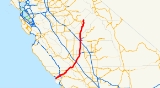
State Route 41 is a state highway
in the U.S. state
of California
, connecting the Cabrillo Highway (SR 1
) in Morro Bay
with Fresno
and Yosemite National Park
via the San Joaquin Valley
. Except between US 101 in Atascadero
and SR 46
near Shandon
, SR 41 is part of the California Freeway and Expressway System
. It has been constructed as an expressway
from near SR 198
in Lemoore
north to the south part of Fresno
, where the Yosemite Freeway begins, passing along the east side of downtown and extending north into Madera County
.
, and SR 49
at Oakhurst
to Yosemite (the Wawona Road) - are eligible for inclusion in the State Scenic Highway System
, but none of the route has been officially designated as such.
SR 41 is known as the E.G. Lewis Highway from SR 1 to US 101 in San Luis Obispo County, the Dwight David Eisenhower Memorial Freeway from Ventura Avenue in Fresno to Herndon Avenue in Fresno, the Donald DeMers Highway from Jensen Avenue in Fresno to Elkhorn Avenue, the Yosemite Freeway from Elkhorn Avenue to the Fresno-Madera County line, the Southern Yosemite Highway from the Fresno-Madera County line to Yosemite National Park, and the Wawona Road from Fresno to Yosemite National Park.
The majority of Route 41 runs as either two-lane rural highway or four-lane divided highway. The southern end of the freeway intersects SR 1
in Morro Bay
. Between Morro Bay and Fresno
, the highway intersects U.S. Route 101 in Atascadero
, proceeds through the Coastal Range and intersects SR 46. Actor James Dean
died in an accident at the intersection of SR 46
in Cholame
. Currently, there is a memorial located there. The interchange is now called the James Dean Memorial Interchange. SR 41 then intersects Interstate 5
to the south of Kettleman City
, and SR 198
just outside of the city of Lemoore
. A large hazardous waste and municipal solid waste disposal facility operated by Waste Management, Inc. is located 5.6 km (3.5 mi) SSW of Kettleman City on the west side of the highway. The El Adobe de los Robles Rancho built by pioneer Daniel Rhoads
can be found north of Lemoore
.
In Fresno, the route intersects SR 99
near Jensen Avenue. Compete access is not available between SR 41/SR 99. For example, there is no direct connector between the southbound SR 41 and northbound SR 99; drivers wanting to make this transition must exit at the SR 41/SR 180 interchange, head west on SR 180, and then transition onto SR 99 at the interchange between those two freeways. Likewise, there is no direct connector between the northbound SR 41 and the southbound SR 99. Drivers must exit at Jensen Avenue, head east on Jensen Avenue until its junction with SR 99 a half-mile east of SR 41, and then make the southbound transition onto SR 99.
SR 41 continues north into the city, then intersects SR 180
at a section of the latter route that links SR 41 to both SR 99 to the west, and to SR 168
to the east. North of Fresno, the route crosses the San Joaquin River, and enters Madera County
near Children's Hospital of Central California
. 8.5 miles (13.7 km) further north, Route 41 intersects with SR 145
, before entering California's Sierra-Nevada mountain range. Route 41 continues through the towns of Coarsegold
and Oakhurst
, where it intersects with SR 49
. Route 41 ends in Yosemite National Park
to the north.
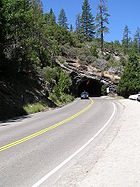 Tunnel View
is a viewpoint located just outside the east end of the Wawona Tunnel in Yosemite National Park. It is located about 1.5 miles (2.4 km) from the Yosemite Valley
. This is the first view that most people have of Yosemite Valley. There is an END-41 sign just south of the southern entrance to Yosemite National Park
. The state routes within the park are not signed (with the exception of SR 120
). Tunnel View is along Route 41's alignment, although state maintenance of the route ends at the south entrance of the park.
, Kings
, Kern
, and San Luis Obispo
considered organizing a joint highway district to construct a shortcut connecting Fresno
with the Pacific Ocean
at Morro Bay
. This highway would pass through Kettleman City
on its way to the Cholame Lateral (Legislative Route 33) near Cholame
or Shandon
, and then continue to Morro Bay, where a new harbor
was being developed. The entire length from Fresno to Morro Bay, as well as the Wawona Road to Yosemite, was added to the state highway system in 1933 as Route 125, and subsequently improved by the state. In 1934, the state sign route system was established, and Sign Route 41 was designated along Route 125 from Yosemite south and southwest to Cholame and then west through Paso Robles
to Cambria
via Legislative Route 33. The part of Route 125 southwest of Cholame instead became part of the new U.S. Route 466.
By the 1950s, the short piece of US 466 (Route 125) between Creston
and Atascadero
had not yet been paved, and so US 466 was moved to the longer but better road via Paso Robles, replacing SR 41 to Paso Robles and overlapping US 101 to Atascadero. As SR 41 had not been signed over the unpaved road west of Paso Robles, it was truncated to Cholame. US 466 was eliminated in the 1964 renumbering, becoming SR 46
east from Paso Robles. However, instead of going south and west to Morro Bay, SR 46 continued west to Cambria, and the road via Creston and Atascadero to Morro Bay (which had since been paved) became part of SR 41.
In the 1980s, the urban stretch of 41 running through Fresno
was upgraded to freeway standards, intersecting SR 99
to the south. In the late 1990s and early 2000s, the freeway portion was extended several miles beyond Fresno in both directions.
|colspan=4 align=center|South end of freeway
|-
|colspan=4 align=center|North end of freeway
|-
|colspan=5 align=center|South end of freeway
|-
|colspan=5 align=center|North end of freeway
State highway
State highway, state road or state route can refer to one of three related concepts, two of them related to a state or provincial government in a country that is divided into states or provinces :#A...
in the U.S. state
U.S. state
A U.S. state is any one of the 50 federated states of the United States of America that share sovereignty with the federal government. Because of this shared sovereignty, an American is a citizen both of the federal entity and of his or her state of domicile. Four states use the official title of...
of California
California
California is a state located on the West Coast of the United States. It is by far the most populous U.S. state, and the third-largest by land area...
, connecting the Cabrillo Highway (SR 1
California State Route 1
State Route 1 , more often called Highway 1, is a state highway that runs along much of the Pacific coast of the U.S. state of California. It is famous for running along some of the most beautiful coastlines in the world, leading to its designation as an All-American Road.Highway 1 does not run...
) in Morro Bay
Morro Bay, California
Morro Bay is a waterfront city in San Luis Obispo County, California, United States. As of the 2010 census, the city population was 10,234, down from 10,350 at the 2000 census.- History :...
with Fresno
Fresno, California
Fresno is a city in central California, United States, the county seat of Fresno County. As of the 2010 census, the city's population was 510,365, making it the fifth largest city in California, the largest inland city in California, and the 34th largest in the nation...
and Yosemite National Park
Yosemite National Park
Yosemite National Park is a United States National Park spanning eastern portions of Tuolumne, Mariposa and Madera counties in east central California, United States. The park covers an area of and reaches across the western slopes of the Sierra Nevada mountain chain...
via the San Joaquin Valley
San Joaquin Valley
The San Joaquin Valley is the area of the Central Valley of California that lies south of the Sacramento – San Joaquin River Delta in Stockton...
. Except between US 101 in Atascadero
Atascadero, California
Atascadero is a city in San Luis Obispo County, California, about equidistant from San Francisco and Los Angeles on U-S Highway 101. Atascadero is farther inland than most other San Luis Obispo County cities, and as a result, usually experiences warmer, drier summers and cooler winters than...
and SR 46
California State Route 46
State Route 46 is an east–west state highway in the U.S. state of California. It is a major crossing of the Coast Ranges, connecting SR 1 on the Central Coast near Cambria and US 101 in Paso Robles with SR 99 at Famoso in the San Joaquin Valley. East of Paso Robles, where it carried U.S...
near Shandon
Shandon, California
Shandon is a census-designated place in San Luis Obispo County, California, United States. The population was 1,295 at the 2010 census, up from 986 at the 2000 census.-Setting:...
, SR 41 is part of the California Freeway and Expressway System
California Freeway and Expressway System
The California Freeway and Expressway System is a system of existing or planned freeways and expressways in the U.S. state of California. It is defined by the Streets and Highways Code.-List of roads in the system:*State Route 1 *State Route 2...
. It has been constructed as an expressway
Limited-access road
A limited-access road known by various terms worldwide, including limited-access highway, dual-carriageway and expressway, is a highway or arterial road for high-speed traffic which has many or most characteristics of a controlled-access highway , including limited or no access to adjacent...
from near SR 198
California State Route 198
State Route 198 is an east–west state highway that connects the California Central Coast to the mid-Central Valley at Visalia, although the most-traveled portion is in the Central Valley itself....
in Lemoore
Lemoore, California
Lemoore is a city in Kings County, California, United States. Lemoore is located west-southwest of Hanford, at an elevation of 230 feet . It is part of the Hanford–Corcoran Metropolitan Statistical Area...
north to the south part of Fresno
Fresno, California
Fresno is a city in central California, United States, the county seat of Fresno County. As of the 2010 census, the city's population was 510,365, making it the fifth largest city in California, the largest inland city in California, and the 34th largest in the nation...
, where the Yosemite Freeway begins, passing along the east side of downtown and extending north into Madera County
Madera County, California
Madera County is a county of the U.S. state of California, located in the Central Valley and the Sierra Nevada north of Fresno County. It comprises the Madera-Chowchilla, CA Metropolitan Statistical Area. As of the 2010 census the population was 150,865...
.
Route description
Three segments — from SR 1 to US 101, SR 46 to SR 33California State Route 33
State Route 33 is a north–south state highway in the U.S. state of California. SR 33 replaced part of U.S. Route 399 in 1964 during the "great renumbering" of routes. In the unincorporated sections of Kern County it is known as the West Side Highway...
, and SR 49
California State Route 49
State Route 49 is a north–south state highway in the U.S. state of California that passes through many historic mining communities of the 1849 California gold rush. Highway 49 is numbered after the "49ers", the waves of immigrants who swept into the area looking for gold, and a portion of it...
at Oakhurst
Oakhurst, California
Oakhurst is a census-designated place in Madera County, California, south of the entrance to Yosemite National Park, in the foothills of the Sierra Nevada mountain range. Oakhurst is located on the Fresno River south-southwest of Yosemite Forks, at an elevation of 2274 feet...
to Yosemite (the Wawona Road) - are eligible for inclusion in the State Scenic Highway System
State Scenic Highway System (California)
The State Scenic Highway System is a list of highways, mainly state highways, that have been designated by the California Department of Transportation as scenic highways. The California State Legislature, primarily through Section 263 of the Streets and Highways Code, makes highways eligible for...
, but none of the route has been officially designated as such.
SR 41 is known as the E.G. Lewis Highway from SR 1 to US 101 in San Luis Obispo County, the Dwight David Eisenhower Memorial Freeway from Ventura Avenue in Fresno to Herndon Avenue in Fresno, the Donald DeMers Highway from Jensen Avenue in Fresno to Elkhorn Avenue, the Yosemite Freeway from Elkhorn Avenue to the Fresno-Madera County line, the Southern Yosemite Highway from the Fresno-Madera County line to Yosemite National Park, and the Wawona Road from Fresno to Yosemite National Park.
The majority of Route 41 runs as either two-lane rural highway or four-lane divided highway. The southern end of the freeway intersects SR 1
California State Route 1
State Route 1 , more often called Highway 1, is a state highway that runs along much of the Pacific coast of the U.S. state of California. It is famous for running along some of the most beautiful coastlines in the world, leading to its designation as an All-American Road.Highway 1 does not run...
in Morro Bay
Morro Bay, California
Morro Bay is a waterfront city in San Luis Obispo County, California, United States. As of the 2010 census, the city population was 10,234, down from 10,350 at the 2000 census.- History :...
. Between Morro Bay and Fresno
Fresno, California
Fresno is a city in central California, United States, the county seat of Fresno County. As of the 2010 census, the city's population was 510,365, making it the fifth largest city in California, the largest inland city in California, and the 34th largest in the nation...
, the highway intersects U.S. Route 101 in Atascadero
Atascadero, California
Atascadero is a city in San Luis Obispo County, California, about equidistant from San Francisco and Los Angeles on U-S Highway 101. Atascadero is farther inland than most other San Luis Obispo County cities, and as a result, usually experiences warmer, drier summers and cooler winters than...
, proceeds through the Coastal Range and intersects SR 46. Actor James Dean
James Dean
James Byron Dean was an American film actor. He is a cultural icon, best embodied in the title of his most celebrated film, Rebel Without a Cause , in which he starred as troubled Los Angeles teenager Jim Stark...
died in an accident at the intersection of SR 46
California State Route 46
State Route 46 is an east–west state highway in the U.S. state of California. It is a major crossing of the Coast Ranges, connecting SR 1 on the Central Coast near Cambria and US 101 in Paso Robles with SR 99 at Famoso in the San Joaquin Valley. East of Paso Robles, where it carried U.S...
in Cholame
Cholame, California
Cholame, California is an unincorporated community in San Luis Obispo County, California, USA. It sits within a mile of the San Andreas Rift Zone fault line at an elevation of 1,157 feet above sea level and is located at . Cholame is reached via State Route 41, just southwest of the junction of...
. Currently, there is a memorial located there. The interchange is now called the James Dean Memorial Interchange. SR 41 then intersects Interstate 5
Interstate 5 in California
Interstate 5 is a major north–south route of the Interstate Highway System in the U.S. state of California. It begins at the Mexico – United States border at the San Ysidro crossing, goes north across the length of California and crosses into Oregon south of the Medford-Ashland metropolitan...
to the south of Kettleman City
Kettleman City, California
Kettleman City is a census-designated place in Kings County, California, United States. Kettleman City is located southwest of Hanford, at an elevation of 253 feet . It is part of the Hanford–Corcoran Metropolitan Statistical Area. The population was 1,439 at the 2010 census, down from...
, and SR 198
California State Route 198
State Route 198 is an east–west state highway that connects the California Central Coast to the mid-Central Valley at Visalia, although the most-traveled portion is in the Central Valley itself....
just outside of the city of Lemoore
Lemoore, California
Lemoore is a city in Kings County, California, United States. Lemoore is located west-southwest of Hanford, at an elevation of 230 feet . It is part of the Hanford–Corcoran Metropolitan Statistical Area...
. A large hazardous waste and municipal solid waste disposal facility operated by Waste Management, Inc. is located 5.6 km (3.5 mi) SSW of Kettleman City on the west side of the highway. The El Adobe de los Robles Rancho built by pioneer Daniel Rhoads
Daniel Rhoads
Daniel Rhoads was a California, USA, pioneer and rancher who helped rescue the Donner Party....
can be found north of Lemoore
Lemoore, California
Lemoore is a city in Kings County, California, United States. Lemoore is located west-southwest of Hanford, at an elevation of 230 feet . It is part of the Hanford–Corcoran Metropolitan Statistical Area...
.
In Fresno, the route intersects SR 99
California State Route 99
California State Route 99 , commonly known as Highway 99 or, simply, as 99 , is a north–south state highway in the U.S. state of California, stretching almost the entire length of the Central Valley...
near Jensen Avenue. Compete access is not available between SR 41/SR 99. For example, there is no direct connector between the southbound SR 41 and northbound SR 99; drivers wanting to make this transition must exit at the SR 41/SR 180 interchange, head west on SR 180, and then transition onto SR 99 at the interchange between those two freeways. Likewise, there is no direct connector between the northbound SR 41 and the southbound SR 99. Drivers must exit at Jensen Avenue, head east on Jensen Avenue until its junction with SR 99 a half-mile east of SR 41, and then make the southbound transition onto SR 99.
SR 41 continues north into the city, then intersects SR 180
California State Route 180
State Route 180 is a state highway in California, United States, which runs through the heart of the San Joaquin Valley from Mendota through Fresno to Kings Canyon National Park, with an unbuilt segment defined west to Paicines....
at a section of the latter route that links SR 41 to both SR 99 to the west, and to SR 168
California State Route 168
State Route 168 is a state highway in California, USA, which is separated into three distinct segments, in part by the Sierra Nevada mountains....
to the east. North of Fresno, the route crosses the San Joaquin River, and enters Madera County
Madera County, California
Madera County is a county of the U.S. state of California, located in the Central Valley and the Sierra Nevada north of Fresno County. It comprises the Madera-Chowchilla, CA Metropolitan Statistical Area. As of the 2010 census the population was 150,865...
near Children's Hospital of Central California
Children's Hospital Central California
Children's Hospital Central California is a 338 bed pediatric hospital located on the San Joaquin River just north of Fresno, California, USA. The hospital has a service area covering most of California's central San Joaquin Valley. There are more than 500 doctors on the medical staff. It is a...
. 8.5 miles (13.7 km) further north, Route 41 intersects with SR 145
California State Route 145
State Route 145 is a state highway in California, USA, which runs through the heart of the San Joaquin Valley from Interstate 5 north to Route 41 north of Fresno.-Route description:SR 145 is part of the California Freeway and Expressway System....
, before entering California's Sierra-Nevada mountain range. Route 41 continues through the towns of Coarsegold
Coarsegold, California
Coarsegold is a census-designated place in Madera County, California. It is located south-southwest of Yosemite Forks, at an elevation of 2218 feet...
and Oakhurst
Oakhurst, California
Oakhurst is a census-designated place in Madera County, California, south of the entrance to Yosemite National Park, in the foothills of the Sierra Nevada mountain range. Oakhurst is located on the Fresno River south-southwest of Yosemite Forks, at an elevation of 2274 feet...
, where it intersects with SR 49
California State Route 49
State Route 49 is a north–south state highway in the U.S. state of California that passes through many historic mining communities of the 1849 California gold rush. Highway 49 is numbered after the "49ers", the waves of immigrants who swept into the area looking for gold, and a portion of it...
. Route 41 ends in Yosemite National Park
Yosemite National Park
Yosemite National Park is a United States National Park spanning eastern portions of Tuolumne, Mariposa and Madera counties in east central California, United States. The park covers an area of and reaches across the western slopes of the Sierra Nevada mountain chain...
to the north.
Tunnel View
Tunnel View, within Yosemite National Park, is a viewpoint on State Route 41 located directly east of the Wawona Tunnel as one enters Yosemite Valley from the South. The view looks east into Yosemite Valley including the southwest face of El Capitan, Half Dome, and Bridalveil Falls. This is, to...
is a viewpoint located just outside the east end of the Wawona Tunnel in Yosemite National Park. It is located about 1.5 miles (2.4 km) from the Yosemite Valley
Yosemite Valley
Yosemite Valley is a glacial valley in Yosemite National Park in the western Sierra Nevada mountains of California, carved out by the Merced River. The valley is about long and up to a mile deep, surrounded by high granite summits such as Half Dome and El Capitan, and densely forested with pines...
. This is the first view that most people have of Yosemite Valley. There is an END-41 sign just south of the southern entrance to Yosemite National Park
Yosemite National Park
Yosemite National Park is a United States National Park spanning eastern portions of Tuolumne, Mariposa and Madera counties in east central California, United States. The park covers an area of and reaches across the western slopes of the Sierra Nevada mountain chain...
. The state routes within the park are not signed (with the exception of SR 120
California State Route 120
State Route 120 , in northern California, runs between the Central Valley near Manteca, through Yosemite National Park, and ends at U.S. Route 6 in Mono County.-Route description:...
). Tunnel View is along Route 41's alignment, although state maintenance of the route ends at the south entrance of the park.
History
In 1930, the counties of FresnoFresno County, California
Fresno County is a county located in the Central Valley of the U.S. state of California, south of Stockton and north of Bakersfield. As of the 2010 census, it is the tenth most populous county in California with a population of 930,450, and the sixth largest in size with an area of . The county...
, Kings
Kings County, California
Kings County is a county located in the Central Valley of the U.S. state of California. It is located in a rich agricultural region. Kings County is also home to NAS Lemoore, which is the U.S. Navy's newest and largest master jet air station. The county seat is Hanford...
, Kern
Kern County, California
Spreading across the southern end of the California Central Valley, Kern County is the fifth-largest county by population in California. Its economy is heavily linked to agriculture and to petroleum extraction, and there is a strong aviation and space presence. Politically, it has generally...
, and San Luis Obispo
San Luis Obispo County, California
San Luis Obispo County is a county located along the Pacific Ocean in the Central Coast of the U.S. state of California, between Los Angeles and the San Francisco Bay Area. As of the 2010 census its population was 269,637, up from 246,681 at the 2000 census...
considered organizing a joint highway district to construct a shortcut connecting Fresno
Fresno, California
Fresno is a city in central California, United States, the county seat of Fresno County. As of the 2010 census, the city's population was 510,365, making it the fifth largest city in California, the largest inland city in California, and the 34th largest in the nation...
with the Pacific Ocean
Pacific Ocean
The Pacific Ocean is the largest of the Earth's oceanic divisions. It extends from the Arctic in the north to the Southern Ocean in the south, bounded by Asia and Australia in the west, and the Americas in the east.At 165.2 million square kilometres in area, this largest division of the World...
at Morro Bay
Morro Bay, California
Morro Bay is a waterfront city in San Luis Obispo County, California, United States. As of the 2010 census, the city population was 10,234, down from 10,350 at the 2000 census.- History :...
. This highway would pass through Kettleman City
Kettleman City, California
Kettleman City is a census-designated place in Kings County, California, United States. Kettleman City is located southwest of Hanford, at an elevation of 253 feet . It is part of the Hanford–Corcoran Metropolitan Statistical Area. The population was 1,439 at the 2010 census, down from...
on its way to the Cholame Lateral (Legislative Route 33) near Cholame
Cholame, California
Cholame, California is an unincorporated community in San Luis Obispo County, California, USA. It sits within a mile of the San Andreas Rift Zone fault line at an elevation of 1,157 feet above sea level and is located at . Cholame is reached via State Route 41, just southwest of the junction of...
or Shandon
Shandon, California
Shandon is a census-designated place in San Luis Obispo County, California, United States. The population was 1,295 at the 2010 census, up from 986 at the 2000 census.-Setting:...
, and then continue to Morro Bay, where a new harbor
Harbor
A harbor or harbour , or haven, is a place where ships, boats, and barges can seek shelter from stormy weather, or else are stored for future use. Harbors can be natural or artificial...
was being developed. The entire length from Fresno to Morro Bay, as well as the Wawona Road to Yosemite, was added to the state highway system in 1933 as Route 125, and subsequently improved by the state. In 1934, the state sign route system was established, and Sign Route 41 was designated along Route 125 from Yosemite south and southwest to Cholame and then west through Paso Robles
Paso Robles, California
Paso Robles is a city in San Luis Obispo County, California, United States. Paso Robles is the fastest growing city in San Luis Obispo County: Its population at the 2000 census was 24,297; in 2010 it recorded some 29,793 residentsLocated on the Salinas River north of San Luis Obispo, California,...
to Cambria
Cambria, California
Cambria is a seaside village located midway between San Francisco and Los Angeles on the California State Route 1 . The name Cambria was settled upon in 1869 .It is a census-designated place in San Luis Obispo County, California, United States...
via Legislative Route 33. The part of Route 125 southwest of Cholame instead became part of the new U.S. Route 466.
By the 1950s, the short piece of US 466 (Route 125) between Creston
Creston, California
Creston is a census-designated place in San Luis Obispo County, California, United States. It is located about 15 miles southeast of the City of Paso Robles.-History:Creston Creston is a census-designated place in San Luis Obispo County, California, United States. It is located about 15 miles...
and Atascadero
Atascadero, California
Atascadero is a city in San Luis Obispo County, California, about equidistant from San Francisco and Los Angeles on U-S Highway 101. Atascadero is farther inland than most other San Luis Obispo County cities, and as a result, usually experiences warmer, drier summers and cooler winters than...
had not yet been paved, and so US 466 was moved to the longer but better road via Paso Robles, replacing SR 41 to Paso Robles and overlapping US 101 to Atascadero. As SR 41 had not been signed over the unpaved road west of Paso Robles, it was truncated to Cholame. US 466 was eliminated in the 1964 renumbering, becoming SR 46
California State Route 46
State Route 46 is an east–west state highway in the U.S. state of California. It is a major crossing of the Coast Ranges, connecting SR 1 on the Central Coast near Cambria and US 101 in Paso Robles with SR 99 at Famoso in the San Joaquin Valley. East of Paso Robles, where it carried U.S...
east from Paso Robles. However, instead of going south and west to Morro Bay, SR 46 continued west to Cambria, and the road via Creston and Atascadero to Morro Bay (which had since been paved) became part of SR 41.
In the 1980s, the urban stretch of 41 running through Fresno
Fresno, California
Fresno is a city in central California, United States, the county seat of Fresno County. As of the 2010 census, the city's population was 510,365, making it the fifth largest city in California, the largest inland city in California, and the 34th largest in the nation...
was upgraded to freeway standards, intersecting SR 99
California State Route 99
California State Route 99 , commonly known as Highway 99 or, simply, as 99 , is a north–south state highway in the U.S. state of California, stretching almost the entire length of the Central Valley...
to the south. In the late 1990s and early 2000s, the freeway portion was extended several miles beyond Fresno in both directions.
Major intersections
|-|colspan=4 align=center|South end of freeway
|-
|colspan=4 align=center|North end of freeway
|-
|colspan=5 align=center|South end of freeway
|-
|colspan=5 align=center|North end of freeway