

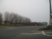
Tule fog
Encyclopedia
Fog
Fog is a collection of water droplets or ice crystals suspended in the air at or near the Earth's surface. While fog is a type of stratus cloud, the term "fog" is typically distinguished from the more generic term "cloud" in that fog is low-lying, and the moisture in the fog is often generated...
that settles in the San Joaquin Valley
San Joaquin Valley
The San Joaquin Valley is the area of the Central Valley of California that lies south of the Sacramento – San Joaquin River Delta in Stockton...
and Sacramento Valley
Sacramento Valley
The Sacramento Valley is the portion of the California Central Valley that lies to the north of the San Joaquin-Sacramento Delta in the U.S. state of California. It encompasses all or parts of ten counties.-Geography:...
areas of California
California
California is a state located on the West Coast of the United States. It is by far the most populous U.S. state, and the third-largest by land area...
's Great Central Valley
California Central Valley
California's Central Valley is a large, flat valley that dominates the central portion of California. It is home to California's most productive agricultural efforts. The valley stretches approximately from northwest to southeast inland and parallel to the Pacific Ocean coast. Its northern half is...
. Tule fog forms during the late fall and winter
Winter
Winter is the coldest season of the year in temperate climates, between autumn and spring. At the winter solstice, the days are shortest and the nights are longest, with days lengthening as the season progresses after the solstice.-Meteorology:...
(California's rainy season) after the first significant rainfall. The official time frame for tule fog to form is from November 1 to March 31. This phenomenon is named after the tule grass
Tule
Schoenoplectus acutus , called tule , common tule, hardstem tule, tule rush, hardstem bulrush, or viscid bulrush, is a giant species of sedge in the plant family Cyperaceae, native to freshwater marshes all over North America...
wetlands (tulares) of the Central Valley. Accidents caused by the tule fog are the leading cause of weather-related casualties in California.
Formation
Tule fog is a radiation fog, which condenses when there is a high relative humidityRelative humidity
Relative humidity is a term used to describe the amount of water vapor in a mixture of air and water vapor. It is defined as the partial pressure of water vapor in the air-water mixture, given as a percentage of the saturated vapor pressure under those conditions...
(typically after a heavy rain), calm winds, and rapid cooling during the night. The nights are longer in the winter months, which creates rapid ground cooling, and thereby a pronounced temperature inversion at a low altitude.
In California, tule fog can extend from Bakersfield
Bakersfield, California
Bakersfield is a city near the southern end of the San Joaquin Valley in Kern County, California. It is roughly equidistant between Fresno and Los Angeles, to the north and south respectively....
to Red Bluff
Red Bluff, California
Red Bluff is a city in and the county seat of Tehama County, California, United States. The population was 14,076 at the 2010 census, up from 13,147 at the 2000 census....
. Tule fog occasionally drifts as far west as the San Francisco Bay Area
San Francisco Bay Area
The San Francisco Bay Area, commonly known as the Bay Area, is a populated region that surrounds the San Francisco and San Pablo estuaries in Northern California. The region encompasses metropolitan areas of San Francisco, Oakland, and San Jose, along with smaller urban and rural areas...
, even drifting westward out the Golden Gate
Golden Gate
The Golden Gate is the North American strait connecting San Francisco Bay to the Pacific Ocean. Since 1937 it has been spanned by the Golden Gate Bridge...
, opposite to the usual course of summertime ocean fog
Marine layer
A marine layer is an air mass which develops over the surface of a large body of water such as the ocean or large lake in the presence of a temperature inversion. The inversion itself is usually initiated by the cooling effect of the water on the surface layer of an otherwise warm air mass...
.
It is formed when cold mountain air flows downslope into the valley during the night, pooling in the low areas until it fills the valley to the "brim" formed by the Coast Ranges and the Sierra Nevada. This occurs because most areas in the Great Central Valley have little or no air drainage below the level of mountain passes. Because of the density of the cold air in the winter, winds are not able to dislodge the fog and the high pressure of the warmer air above the mountaintops presses down on the cold air trapped in the valley, resulting in a dense, immobile fog that can last for days or at times for weeks undisturbed. Tule fog often contains light drizzle or freezing drizzle where temperatures are sufficiently cold.
Tule fog is a low cloud, usually below 1,000 feet in altitude
Altitude
Altitude or height is defined based on the context in which it is used . As a general definition, altitude is a distance measurement, usually in the vertical or "up" direction, between a reference datum and a point or object. The reference datum also often varies according to the context...
and can be seen from above by driving up into the foothills
Foothills
Foothills are geographically defined as gradual increases in elevation at the base of a mountain range. They are a transition zone between plains and low relief hills to the adjacent topographically high mountains.-Examples:...
of the Sierra Nevada to the east or the Coast Ranges to the west. Above the cold, foggy layer, the air is typically warm, dry and clear. Once tule fog is formed, turbulent air is necessary to break through the temperature inversion layer. Daytime heating sometimes evaporates the fog in some areas, although the air remains chilly and hazy below the inversion and reforms right after sunset. Tule fog usually remains longer in the southern and eastern parts of the Central Valley because more winter storms affect the northern Central Valley.
Visibility
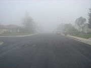
The variability in visibility is the cause of many chain-reaction pile-ups on roads and freeways. In one such accident on Interstate 5
Interstate 5 in California
Interstate 5 is a major north–south route of the Interstate Highway System in the U.S. state of California. It begins at the Mexico – United States border at the San Ysidro crossing, goes north across the length of California and crosses into Oregon south of the Medford-Ashland metropolitan...
near Elk Grove
Elk Grove, California
Elk Grove is a city in Sacramento County, California, located just south of the state capital of Sacramento. It is part of the Sacramento–Arden-Arcade–Roseville Metropolitan Statistical Area. As of the 2010 census, the population of the city is 153,015...
south of Sacramento
Sacramento, California
Sacramento is the capital city of the U.S. state of California and the county seat of Sacramento County. It is located at the confluence of the Sacramento River and the American River in the northern portion of California's expansive Central Valley. With a population of 466,488 at the 2010 census,...
, 25 cars and 12 big-rig trucks collided inside a fog bank in December 1997. Five people died and 28 were injured. In February 2002, two people were killed in an 80-plus car pile-up on State Route 99
California State Route 99
California State Route 99 , commonly known as Highway 99 or, simply, as 99 , is a north–south state highway in the U.S. state of California, stretching almost the entire length of the Central Valley...
between Kingsburg
Kingsburg, California
Kingsburg is a city in Fresno County, California. Kingsburg is located southeast of Selma at an elevation of 302 feet , on the banks of the Kings River. The city is half an hour away from Fresno, and two hours away from the California Central Coast and Sierra Nevada Mountain Range...
and Selma
Selma, California
Selma is a city in Fresno County, California. The population was 23,219 at the 2010 census, up from 19,240 at the 2000 census. Selma is located southeast of Fresno, at an elevation of 308 feet .-Geography:...
. The visibility at the time of the accident was zero. On the morning of November 3, 2007, heavy tule fog caused a massive pile-up that included 108 passenger vehicles and 18 big rig trucks on Northbound State Route 99 between Fowler
Fowler, California
Fowler is a city in Fresno County, California, United States. It is located within the San Joaquin Valley. It has a strong agricultural community, with lush grape vineyards and expansive farmland. Fowler is located southeast of downtown Fresno, at an elevation of 308 feet...
and Fresno
Fresno, California
Fresno is a city in central California, United States, the county seat of Fresno County. As of the 2010 census, the city's population was 510,365, making it the fifth largest city in California, the largest inland city in California, and the 34th largest in the nation...
. Visibility was about 200 feet at the time of the accident. There were two fatalities and 39 injuries in the crash.
Freezing drizzle and black ice
Tule fog events are often accompanied by drizzle and freezing drizzle. Because of the lack of sunlight penetrating the fog layer, temperatures may struggle to climb above freezing, and episodes of freezing drizzleFreezing drizzle
Freezing drizzle is drizzle that freezes on contact with the ground or an object at or near the surface. Its METAR code is FZDZ. When freezing drizzle accumulates on land it creates an icy layer of glaze...
occasionally accompany tule fog events during winter. Such events can leave an invisible glaze of black ice
Black ice
Black ice, sometimes called glare ice or clear ice, refers to a thin coating of glazed ice on a surface.While not truly black, it is virtually transparent, allowing black asphalt/macadam roadways to be seen through it, hence the term "black ice"...
on roadways, making travel especially treacherous.
External links
- Page on tule fog from the National Oceanic and Atmospheric Administration (NOAA)National Oceanic and Atmospheric AdministrationThe National Oceanic and Atmospheric Administration , pronounced , like "noah", is a scientific agency within the United States Department of Commerce focused on the conditions of the oceans and the atmosphere...
- Forecasting Radiation Fog University Corporation for Atmospheric Research