
California State Route 269
Encyclopedia
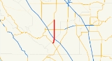
State Route 269 is a state highway
in California
, USA, which runs from Avenal
to State Route 145.
at I-5. In the city of Avenal, it is known as Skyline Boulevard. From the Fresno
-Kings
county line, right before I-5 to its northern terminus at SR 145
, the road is known as Lassen Avenue and heads due north through Huron
.
number 269 was defined as "from LRN 61 to LRN 23 south of Palmdale." Today, this route is Angeles Forest Highway
and Los Angeles County Route N3. The route was defined as a California State route in 1972 as "SR 33
at Avenal to SR 145
near Five Points.”
{| class=wikitable
!County
!Location
!Postmile
!Destinations
!Notes
|-
|Kings
KIN 0.00-5.62
|Avenal
|0.00
|
|
|-
|rowspan=4|Fresno
FRE 0.00-24.76
|
|0.43
|
|Interchange
|-
|
|
|.svg.png) Jayne Avenue to I-5 north – Coalinga
Jayne Avenue to I-5 north – Coalinga
|
|-
|
|12.75
|
|
|-
|Five Points
|24.76
|
|
State highway
State highway, state road or state route can refer to one of three related concepts, two of them related to a state or provincial government in a country that is divided into states or provinces :#A...
in California
California
California is a state located on the West Coast of the United States. It is by far the most populous U.S. state, and the third-largest by land area...
, USA, which runs from Avenal
Avenal, California
Avenal is a city in Kings County, California, United States. Avenal is located southwest of Hanford, at an elevation of 807 feet . It is part of the Hanford–Corcoran Metropolitan Statistical Area , which encompasses all of Kings County. In area, it is the largest city in Kings County...
to State Route 145.
Route description
The southern terminus of SR 269 is at State Route 33 in Avenal, where it drops into the San Joaquin ValleySan Joaquin Valley
The San Joaquin Valley is the area of the Central Valley of California that lies south of the Sacramento – San Joaquin River Delta in Stockton...
at I-5. In the city of Avenal, it is known as Skyline Boulevard. From the Fresno
Fresno County, California
Fresno County is a county located in the Central Valley of the U.S. state of California, south of Stockton and north of Bakersfield. As of the 2010 census, it is the tenth most populous county in California with a population of 930,450, and the sixth largest in size with an area of . The county...
-Kings
Kings County, California
Kings County is a county located in the Central Valley of the U.S. state of California. It is located in a rich agricultural region. Kings County is also home to NAS Lemoore, which is the U.S. Navy's newest and largest master jet air station. The county seat is Hanford...
county line, right before I-5 to its northern terminus at SR 145
California State Route 145
State Route 145 is a state highway in California, USA, which runs through the heart of the San Joaquin Valley from Interstate 5 north to Route 41 north of Fresno.-Route description:SR 145 is part of the California Freeway and Expressway System....
, the road is known as Lassen Avenue and heads due north through Huron
Huron, California
Huron is a small city in Fresno County, California, in the United States. As of the 2010 census, the population was 6,754, up from 6,306 at the 2000 census. During the harvest season, the population swells to over 15,000 people due to the influx of migrant farm workers. Huron is located ...
.
History
In 1959, Legislative RouteLegislative route
In United States, a legislative route or legislative highway is a highway defined by laws passed in a state legislature. The numbering of such highways may or may not correspond to the numbers familiar to the public as part of the state, U.S. highway, and Interstate highway systems...
number 269 was defined as "from LRN 61 to LRN 23 south of Palmdale." Today, this route is Angeles Forest Highway
Angeles Forest Highway
The Angeles Forest Highway traverses the Angeles National Forest and connects the Los Angeles basin to the Antelope Valley by going up and over the San Gabriel Mountains. The highway is variously known as County Road N-3 or FH-59 or the Palmdale cutoff. It is about long...
and Los Angeles County Route N3. The route was defined as a California State route in 1972 as "SR 33
California State Route 33
State Route 33 is a north–south state highway in the U.S. state of California. SR 33 replaced part of U.S. Route 399 in 1964 during the "great renumbering" of routes. In the unincorporated sections of Kern County it is known as the West Side Highway...
at Avenal to SR 145
California State Route 145
State Route 145 is a state highway in California, USA, which runs through the heart of the San Joaquin Valley from Interstate 5 north to Route 41 north of Fresno.-Route description:SR 145 is part of the California Freeway and Expressway System....
near Five Points.”
Major intersections
- Note: Except where prefixed with a letter, postmiles were measured in 1964, based on the alignment as it existed at that time, and do not necessarily reflect current mileage. The numbers reset at county lines; the start and end postmiles in each county are given in the county column.
{| class=wikitable
!County
!Location
!Postmile
!Destinations
!Notes
|-
|Kings
Kings County, California
Kings County is a county located in the Central Valley of the U.S. state of California. It is located in a rich agricultural region. Kings County is also home to NAS Lemoore, which is the U.S. Navy's newest and largest master jet air station. The county seat is Hanford...
KIN 0.00-5.62
|Avenal
Avenal, California
Avenal is a city in Kings County, California, United States. Avenal is located southwest of Hanford, at an elevation of 807 feet . It is part of the Hanford–Corcoran Metropolitan Statistical Area , which encompasses all of Kings County. In area, it is the largest city in Kings County...
|0.00
|
|
|-
|rowspan=4|Fresno
Fresno County, California
Fresno County is a county located in the Central Valley of the U.S. state of California, south of Stockton and north of Bakersfield. As of the 2010 census, it is the tenth most populous county in California with a population of 930,450, and the sixth largest in size with an area of . The county...
FRE 0.00-24.76
|
|0.43
|
|Interchange
|-
|
|
|
Jayne Avenue to I-5 north – CoalingaCoalinga, California
Coalinga is a city in Fresno County, California. The population was 13,380 at the 2010 census, up from 11,668 at the 2000 census. It is the site of both Pleasant Valley State Prison and Coalinga State Hospital. Coalinga is located southwest of Fresno, at an elevation of 673 feet .-Early...
|
|-
|
|12.75
|
|
|-
|Five Points
Five Points, Fresno County, California
Five Points is an unincorporated community in Fresno County, California. It is located northeast of Coalinga, at an elevation of 223 feet .A post office opened at Five Points in 1944....
|24.76
|
|