
Maryland Route 66
Encyclopedia
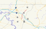
Maryland Route 66 is a state highway
in the U.S. state
of Maryland
. Known for most of its length as Mapleville Road, the state highway runs 12.84 miles (20.7 km) from U.S. Route 40 Alternate (US 40 Alternate) in Boonsboro
north to MD 64
near Smithsburg
. MD 66 parallels the western flank of South Mountain
in eastern Washington County
, connecting Boonsboro and Smithsburg with Interstate 70
(I-70) and US 40
. MD 66 was constructed in the late 1920s and early 1930s from Boonsboro to Cavetown
. The state highway was extended north through Smithsburg after MD 64 bypassed the town in the late 1950s.
in Boonsboro. The state highway heads northeast as Maple Avenue, passing Boonsboro High School
before leaving the town. MD 66 continues north as Mapleville Road, passing through farmland and the villages of Mapleville
and San Mar
. The state highway continues north through the unincorporated town of Beaver Creek
, where the highway intersects both US 40 (National Pike) and Beaver Creek Road at oblique angles at Wagner's Crossroads. MD 66 passes by Beaver Creek Country Club and crosses Blackrock Creek before the highway temporarily expands to a four-lane divided highway through its diamond interchange
with I-70 (Eisenhower Memorial Highway).
MD 66 continues northeast through a mix of farmland and forest, passing between a pair of quarries before reaching the roundabout
at which the highway meets Mount Aetna Road in the community of Mount Aetna
, which is home to the Highland View Academy
. The state highway crosses Beaver Creek and passes to the west of Jugtown
and between the historic homes The Maples
and The Willows
. After intersecting MD 64 (Smithsburg Pike), MD 66 passes through Cavetown, where the highway intersects Old Georgetown Road and Cavetown Church Road, which are the old alignments of MD 64 and MD 77
, respectively. The state highway crosses Beaver Creek again and crosses CSX
's Hanover Subdivision
at-grade at a rakish angle before entering the town of Smithsburg, where MD 66 is municipally-maintained. MD 66 heads northeast through the town as Water Street. Shortly after intersecting Main Street, MD 66 turns north onto Pennsylvania Avenue. At the northern town limit, state maintenance resumes and the highway's name changes to Bradbury Avenue. MD 66 continues north through a mix of farms and residences to its northern terminus at MD 64 (Smithsburg Pike) north of Smithsburg.
.
{| class=wikitable
!Location
!Mile
!Destinations
!Notes
|-
|Boonsboro
|0.00
|
|Southern terminus
|-
|rowspan=2|Beaver Creek
|4.25
|
|
|-
|5.33
|
|I-70 Exit 35
|-
|Mount Aetna
|6.76
|Mount Aetna Road
|Roundabout
|-
|Cavetown
|10.32
|
|
|-
|rowspan=2|Smithsburg
|11.66
|Water Street east
|MD 66 turns north onto Pennsylvania Avenue
|-
|12.84
|
|Northern terminus
State highway
State highway, state road or state route can refer to one of three related concepts, two of them related to a state or provincial government in a country that is divided into states or provinces :#A...
in the U.S. state
U.S. state
A U.S. state is any one of the 50 federated states of the United States of America that share sovereignty with the federal government. Because of this shared sovereignty, an American is a citizen both of the federal entity and of his or her state of domicile. Four states use the official title of...
of Maryland
Maryland
Maryland is a U.S. state located in the Mid Atlantic region of the United States, bordering Virginia, West Virginia, and the District of Columbia to its south and west; Pennsylvania to its north; and Delaware to its east...
. Known for most of its length as Mapleville Road, the state highway runs 12.84 miles (20.7 km) from U.S. Route 40 Alternate (US 40 Alternate) in Boonsboro
Boonsboro, Maryland
Boonsboro is a town in Washington County, Maryland, United States, located at the foot of South Mountain. It nearly borders Frederick County and is proximate to the Antietam National Battlefield...
north to MD 64
Maryland Route 64
Maryland Route 64 is a state highway in the U.S. state of Maryland. The state highway runs from U.S. Route 40 in Hagerstown east to the Pennsylvania state line near Ringgold, where the highway continues as Pennsylvania Route 997...
near Smithsburg
Smithsburg, Maryland
Smithsburg is a town in Washington County, Maryland, United States. Its population was 2,146 at the 2000 census and latest 2008 estimates are at 2,908. Smithsburg is close to Fort Ritchie army base and just west of the presidential retreat Camp David....
. MD 66 parallels the western flank of South Mountain
South Mountain (Maryland and Pennsylvania)
South Mountain is the northern extension of the Blue Ridge Mountain range in Maryland and Pennsylvania. From the Potomac River near Knoxville, Maryland in the south, to Dillsburg, Pennsylvania in the north, the long range separates the Hagerstown and Cumberland valleys from the Piedmont regions of...
in eastern Washington County
Washington County, Maryland
Washington County is a county located in the western part of the U.S. state of Maryland, bordering southern Pennsylvania to the north, northern Virginia to the south, and the Eastern Panhandle of West Virginia to the south and west. As of the 2010 Census, its population is 147,430...
, connecting Boonsboro and Smithsburg with Interstate 70
Interstate 70 in Maryland
Interstate 70 is a part of the Interstate Highway System that runs from Cove Fort, Utah to Baltimore, Maryland. In Maryland, the Interstate Highway runs from the Pennsylvania state line in Hancock east to the Interstate's eastern terminus near its junction with I-695 at a park and ride in...
(I-70) and US 40
U.S. Route 40 in Maryland
U.S. Route 40 in the U.S. state of Maryland runs from western Maryland to Cecil County in the state's northeastern corner. With a total length of over , it is the longest numbered highway in Maryland. Almost half of the road overlaps with Interstate 68 or Interstate 70, while the old alignment...
. MD 66 was constructed in the late 1920s and early 1930s from Boonsboro to Cavetown
Cavetown, Maryland
Cavetown is a census-designated place in Washington County, Maryland, United States. The population was 1,486 at the 2000 census.-Geography:Cavetown is located at ....
. The state highway was extended north through Smithsburg after MD 64 bypassed the town in the late 1950s.
Route description
MD 66 begins at an intersection with US 40 Alternate (Main Street) near the Bowman HouseBowman House (Boonsboro, Maryland)
The Bowman House is a log house in Boonsboro, Maryland, United States, typical of those built in the area in the early 19th century. It and its immediate grounds housed the "Boonsboro Pottery" from 1868, owned by John E. Bowman. The pottery closed by 1908, succumbing to mass-produced materials...
in Boonsboro. The state highway heads northeast as Maple Avenue, passing Boonsboro High School
Boonsboro High School
Boonsboro High School is a public high school in Boonsboro, Washington County, Maryland, United States. The present school building was created in 1958 and renovated in 1975-76, 2006...
before leaving the town. MD 66 continues north as Mapleville Road, passing through farmland and the villages of Mapleville
Mapleville, Maryland
Mapleville is an unincorporated community in eastern Washington County, Maryland, United States. The community is not considered a census-designated place , but is officially a part of the Hagerstown Metropolitan Area....
and San Mar
San Mar, Maryland
San Mar is a census-designated place in Washington County, Maryland, United States. The population was 515 at the 2000 census.-Geography:San Mar is located at ....
. The state highway continues north through the unincorporated town of Beaver Creek
Beaver Creek, Maryland
Beaver Creek is an unincorporated community in eastern Washington County, Maryland, United States. It is located southeast of Hagerstown and north of Boonsboro near U.S. Route 40 and Maryland Route 66...
, where the highway intersects both US 40 (National Pike) and Beaver Creek Road at oblique angles at Wagner's Crossroads. MD 66 passes by Beaver Creek Country Club and crosses Blackrock Creek before the highway temporarily expands to a four-lane divided highway through its diamond interchange
Diamond interchange
A diamond interchange is a common type of road junction, used where a freeway crosses a minor road. The freeway itself is grade-separated from the minor road, one crossing the other over a bridge...
with I-70 (Eisenhower Memorial Highway).
MD 66 continues northeast through a mix of farmland and forest, passing between a pair of quarries before reaching the roundabout
Roundabout
A roundabout is the name for a road junction in which traffic moves in one direction around a central island. The word dates from the early 20th century. Roundabouts are common in many countries around the world...
at which the highway meets Mount Aetna Road in the community of Mount Aetna
Mount Aetna, Maryland
Mount Aetna is a census-designated place in Washington County, Maryland, United States. The population was 838 at the 2000 census.-Geography:Mount Aetna is located at ....
, which is home to the Highland View Academy
Highland View Academy
Highland View Academy is a private co-educational secondary boarding school located in Hagerstown, Maryland in the United States, and run by the Seventh-day Adventist Church. It is accredited by the Middle States Association of Colleges and Schools -History:...
. The state highway crosses Beaver Creek and passes to the west of Jugtown
Jugtown, Maryland
Jugtown is an unincorporated community in Washington County, Maryland, United States.-References:...
and between the historic homes The Maples
The Maples (Smithsburg, Maryland)
The Maples is a historic home located at Smithsburg, Washington County, Maryland, United States. It is a two-story, six-bay stone and log dwelling trimmed in black and white. The house features a rather elaborate neoclassical cornice with dentils matching the entrance frontispiece and extending...
and The Willows
The Willows (Cavetown, Maryland)
The Willows is a historic farm complex located at Cavetown, Washington County, Maryland, United States. The farmhouse is a four bay long two-story Federal brick structure that is painted white...
. After intersecting MD 64 (Smithsburg Pike), MD 66 passes through Cavetown, where the highway intersects Old Georgetown Road and Cavetown Church Road, which are the old alignments of MD 64 and MD 77
Maryland Route 77
Maryland Route 77 is a state highway in the U.S. state of Maryland. The state highway runs from MD 64 in Smithsburg east to MD 194 in Keymar. MD 77 is the main east–west highway of northern Frederick County...
, respectively. The state highway crosses Beaver Creek again and crosses CSX
CSX Transportation
CSX Transportation operates a Class I railroad in the United States known as the CSX Railroad. It is the main subsidiary of the CSX Corporation. The company is headquartered in Jacksonville, Florida, and owns approximately 21,000 route miles...
's Hanover Subdivision
Hanover Subdivision
The Hanover Subdivision is a railroad line owned and operated by CSX Transportation in the U.S. states of Maryland and Pennsylvania. The line runs from Baltimore, Maryland west to Hagerstown, Maryland along several former Western Maryland Railway lines...
at-grade at a rakish angle before entering the town of Smithsburg, where MD 66 is municipally-maintained. MD 66 heads northeast through the town as Water Street. Shortly after intersecting Main Street, MD 66 turns north onto Pennsylvania Avenue. At the northern town limit, state maintenance resumes and the highway's name changes to Bradbury Avenue. MD 66 continues north through a mix of farms and residences to its northern terminus at MD 64 (Smithsburg Pike) north of Smithsburg.
History
The first sections of modern MD 66 to be paved were constructed as part of MD 64. Bradbury Avenue north of Smithsburg was paved in 1916. The remainder of MD 64 was completed in 1923. The remainder of MD 66 was paved starting from Boonsboro in 1925. By 1927, the highway was paved north to Beaver Creek. In 1928, MD 66 was extended north to Mount Aetna. The state highway was completed to Chewsville Road in 1929. The final segment of MD 66 south of Cavetown was completed in 1933. Following the completion of MD 64's bypass of Cavetown and Smithsburg in 1958, MD 66 was extended north through Smithsburg over MD 64's old alignment. MD 66 was expanded to a four-lane divided highway at I-70 concurrent with the construction of the highway's interchange with I-70 in 1968. The roundabout at the intersection with Mount Aetna Road was constructed in 2002.Junction list
The entire route is in Washington CountyWashington County, Maryland
Washington County is a county located in the western part of the U.S. state of Maryland, bordering southern Pennsylvania to the north, northern Virginia to the south, and the Eastern Panhandle of West Virginia to the south and west. As of the 2010 Census, its population is 147,430...
.
{| class=wikitable
!Location
!Mile
!Destinations
!Notes
|-
|Boonsboro
Boonsboro, Maryland
Boonsboro is a town in Washington County, Maryland, United States, located at the foot of South Mountain. It nearly borders Frederick County and is proximate to the Antietam National Battlefield...
|0.00
|
|Southern terminus
|-
|rowspan=2|Beaver Creek
Beaver Creek, Maryland
Beaver Creek is an unincorporated community in eastern Washington County, Maryland, United States. It is located southeast of Hagerstown and north of Boonsboro near U.S. Route 40 and Maryland Route 66...
|4.25
|
|
|-
|5.33
|
|I-70 Exit 35
|-
|Mount Aetna
Mount Aetna, Maryland
Mount Aetna is a census-designated place in Washington County, Maryland, United States. The population was 838 at the 2000 census.-Geography:Mount Aetna is located at ....
|6.76
|Mount Aetna Road
|Roundabout
Roundabout
A roundabout is the name for a road junction in which traffic moves in one direction around a central island. The word dates from the early 20th century. Roundabouts are common in many countries around the world...
|-
|Cavetown
Cavetown, Maryland
Cavetown is a census-designated place in Washington County, Maryland, United States. The population was 1,486 at the 2000 census.-Geography:Cavetown is located at ....
|10.32
|
|
|-
|rowspan=2|Smithsburg
Smithsburg, Maryland
Smithsburg is a town in Washington County, Maryland, United States. Its population was 2,146 at the 2000 census and latest 2008 estimates are at 2,908. Smithsburg is close to Fort Ritchie army base and just west of the presidential retreat Camp David....
|11.66
|Water Street east
|MD 66 turns north onto Pennsylvania Avenue
|-
|12.84
|
|Northern terminus