
Maryland Route 704
Encyclopedia
Maryland Route 704 is a state highway
in the U.S. state
of Maryland
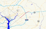
. Known as Martin Luther King Jr. Highway, the state highway runs 6.53 mi (10.5 km) from Eastern Avenue
at the District of Columbia boundary in Seat Pleasant
east to MD 450
in Lanham
.
MD 704 was constructed in the early 1940s from Seat Pleasant to U.S. Route 50
(now MD 450) along the right-of-way of the abandoned Washington, Baltimore and Annapolis Electric Railway
. The highway was expanded to a multi-lane divided highway west of US 50 in the 1960s and 1970s and at its eastern end in 2000.
and East Capitol Street
. MD 704 heads northeast as a six-lane divided highway through the town of Seat Pleasant, where the highway intersects Addison Road. After leaving the town, the state highway crosses Cabin Branch and intersects Sheriff Road at an oblique angle. MD 704 passes through Palmer Park, where the highway traverses Cattail Branch and meets MD 202
(Landover Road) at a full cloverleaf interchange. MD 704 temporarily drops to four lanes through the MD 202 interchange.
MD 704 continues through Glenarden
, where the highway intersects Ardwick Ardmore Road and crosses the Capital Beltway
(Interstate 95
and I-495) with no access. MD 704 drops to four lanes again between Ardwick Ardmore Road and the five-ramp interchange at unsigned
I-595
and US 50, which features a direct ramp to northbound I-95 and I-495 toward Baltimore. MD 704 continues northeast as a six-lane highway across Bald Hill Branch, through office parks, and past a shopping center before reaching its eastern terminus at MD 450 (Annapolis Road) in Lanham.
between 1986 and 1999. The final two-lane portion of the state highway, from just east of US 50 to MD 450, was expanded to a six-lane divided highway in 2000.
.
State highway
State highway, state road or state route can refer to one of three related concepts, two of them related to a state or provincial government in a country that is divided into states or provinces :#A...
in the U.S. state
U.S. state
A U.S. state is any one of the 50 federated states of the United States of America that share sovereignty with the federal government. Because of this shared sovereignty, an American is a citizen both of the federal entity and of his or her state of domicile. Four states use the official title of...
of Maryland
Maryland
Maryland is a U.S. state located in the Mid Atlantic region of the United States, bordering Virginia, West Virginia, and the District of Columbia to its south and west; Pennsylvania to its north; and Delaware to its east...
. Known as Martin Luther King Jr. Highway, the state highway runs 6.53 mi (10.5 km) from Eastern Avenue
Eastern Avenue (Washington, D.C.)
Eastern Avenue is one of three boundary streets between Washington, D.C., and the state of Maryland. It follows a northwest-to-southeast line, beginning at the intersection of 16th Street NW and Colesville Road...
at the District of Columbia boundary in Seat Pleasant
Seat Pleasant, Maryland
Seat Pleasant is an incorporated city in Prince George's County, Maryland, United States immediately east of Washington D.C. The population was 4,885 at the 2000 census. Two state highways run through it — Maryland Route 704 and Maryland Route 214...
east to MD 450
Maryland Route 450
Maryland Route 450 is a state highway in the U.S. state of Maryland. The state highway runs from U.S. Route 1 Alternate in Bladensburg east to US 50, US 301, and MD 2 near Annapolis. MD 450 is the original alignment of US 50 in Prince George's and Anne Arundel Counties...
in Lanham
Lanham, Maryland
Lanham is an unincorporated community in Prince George's County in the State of Maryland in the United States of America. Because it is not formally incorporated, it has no official boundaries, but the United States Census Bureau has defined a census-designated place consisting of Lanham and the...
.
MD 704 was constructed in the early 1940s from Seat Pleasant to U.S. Route 50
U.S. Route 50 in Maryland
U.S. Route 50 is a major east–west route of the U.S. Highway system, stretching just over from Ocean City, Maryland on the Atlantic Ocean to West Sacramento, California. In the U.S. state of Maryland, US 50 exists in two sections. The longer of these serves as a major route connecting...
(now MD 450) along the right-of-way of the abandoned Washington, Baltimore and Annapolis Electric Railway
Washington, Baltimore and Annapolis Electric Railway
The Washington, Baltimore and Annapolis Electric Railway , now defunct, was an American railroad of central Maryland and Washington, DC built in the 19th and 20th century. The WB&A absorbed two older railroads, the Annapolis and Elk Ridge Railroad and the Baltimore & Annapolis Short Line, and...
. The highway was expanded to a multi-lane divided highway west of US 50 in the 1960s and 1970s and at its eastern end in 2000.
Route description
MD 704 begins at an intersection with Eastern Avenue near the eastern corner of the District of Columbia boundary. The highway continues south as 63rd Avenue, which heads south toward Southern AvenueSouthern Avenue (Washington, D.C.)
Southern Avenue is one of three boundary streets between Washington, D.C., and the state of Maryland. Following a southeast-to-northeast line, Southern Avenue begins at the intersection of South Capitol Street, Southeast and Indian Head Highway on the Maryland side. It runs for approximately seven...
and East Capitol Street
East Capitol Street
East Capitol Street is a major street that divides the northeast and southeast quadrants of Washington, D.C. It runs due east from the United States Capitol to the DC-Maryland border. The street is uninterrupted until Lincoln Park then continues eastward to Robert F. Kennedy Memorial Stadium...
. MD 704 heads northeast as a six-lane divided highway through the town of Seat Pleasant, where the highway intersects Addison Road. After leaving the town, the state highway crosses Cabin Branch and intersects Sheriff Road at an oblique angle. MD 704 passes through Palmer Park, where the highway traverses Cattail Branch and meets MD 202
Maryland Route 202
Maryland Route 202 is a north–south state highway in Prince George's County within the U.S. state of Maryland. MD 202 travels through many communities in central Prince George's County, and is known as Maryland Route 202 (MD 202) is a north–south state highway in Prince George's...
(Landover Road) at a full cloverleaf interchange. MD 704 temporarily drops to four lanes through the MD 202 interchange.
MD 704 continues through Glenarden
Glenarden, Maryland
Glenarden is a city in Prince George's County, Maryland, United States. The population was 6,000 at the 2010 census.-Geography:Glenarden is located at ....
, where the highway intersects Ardwick Ardmore Road and crosses the Capital Beltway
Interstate 495 (Capital Beltway)
Interstate 495 is a Interstate Highway that surrounds the United States' capital of Washington, D.C., and its inner suburbs in adjacent Maryland and Virginia. I-495 is widely known as the Capital Beltway or simply the Beltway, especially when the context of Washington, D.C., is clear...
(Interstate 95
Interstate 95 in Maryland
Interstate 95 in Maryland is a major highway that runs diagonally from northeast to southwest, from Maryland's border with Delaware, to the Woodrow Wilson Bridge, briefly entering the District of Columbia before reaching Virginia...
and I-495) with no access. MD 704 drops to four lanes again between Ardwick Ardmore Road and the five-ramp interchange at unsigned
Unsigned highway
An unsigned highway is a highway that has been assigned a route number, but does not bear conventional road markings that would normally be used to identify the route with that number...
I-595
Interstate 595 (Maryland)
Interstate 595 is an unsigned number for a section of the John Hanson Highway from Interstate 495 east of Washington, D.C. to Maryland Route 70 at Annapolis, Maryland....
and US 50, which features a direct ramp to northbound I-95 and I-495 toward Baltimore. MD 704 continues northeast as a six-lane highway across Bald Hill Branch, through office parks, and past a shopping center before reaching its eastern terminus at MD 450 (Annapolis Road) in Lanham.
History
MD 704 was constructed in 1942 on the right-of-way of the Washington, Baltimore and Annapolis Electric Railway, which had ceased operations in 1935. The highway was originally named for George N. Palmer, a community leader in Seat Pleasant. MD 704 was temporarily marked as Temp US 50 when John Hanson Highway's western terminus was at MD 704 between 1959 and the highway's completion west to Washington in the early 1960s. The state highway was expanded to a divided highway from Glenarden to just east of John Hanson Highway around 1964 and within Seat Pleasant by 1970. MD 704 was expanded to a divided highway from Seat Pleasant to Glenarden around 1970. MD 704 was renamed for Martin Luther King, Jr.Martin Luther King, Jr.
Martin Luther King, Jr. was an American clergyman, activist, and prominent leader in the African-American Civil Rights Movement. He is best known for being an iconic figure in the advancement of civil rights in the United States and around the world, using nonviolent methods following the...
between 1986 and 1999. The final two-lane portion of the state highway, from just east of US 50 to MD 450, was expanded to a six-lane divided highway in 2000.
Junction list
The entire route is in Prince George's CountyPrince George's County, Maryland
Prince George's County is a county located in the U.S. state of Maryland, immediately north, east, and south of Washington, DC. As of 2010, it has a population of 863,420 and is the wealthiest African-American majority county in the nation....
.
| Location | Mile |
Destinations | Notes |
|---|---|---|---|
| Seat Pleasant Seat Pleasant, Maryland Seat Pleasant is an incorporated city in Prince George's County, Maryland, United States immediately east of Washington D.C. The population was 4,885 at the 2000 census. Two state highways run through it — Maryland Route 704 and Maryland Route 214... |
0.00 | 63rd Street south to Southern Avenue Southern Avenue (Washington, D.C.) Southern Avenue is one of three boundary streets between Washington, D.C., and the state of Maryland. Following a southeast-to-northeast line, Southern Avenue begins at the intersection of South Capitol Street, Southeast and Indian Head Highway on the Maryland side. It runs for approximately seven... and East Capitol Street East Capitol Street East Capitol Street is a major street that divides the northeast and southeast quadrants of Washington, D.C. It runs due east from the United States Capitol to the DC-Maryland border. The street is uninterrupted until Lincoln Park then continues eastward to Robert F. Kennedy Memorial Stadium... |
Western terminus |
| Eastern Avenue Eastern Avenue (Washington, D.C.) Eastern Avenue is one of three boundary streets between Washington, D.C., and the state of Maryland. It follows a northwest-to-southeast line, beginning at the intersection of 16th Street NW and Colesville Road... |
|||
| 0.27 | Addison Road south – District Heights District Heights, Maryland District Heights is an incorporated city in. Prince George's County, Maryland, United States, located near Maryland Route 4. The population was 5,837 at the 2010 census... |
Former MD 389 | |
| Palmer Park | 3.02 | Cloverleaf interchange | |
| Lanham Lanham, Maryland Lanham is an unincorporated community in Prince George's County in the State of Maryland in the United States of America. Because it is not formally incorporated, it has no official boundaries, but the United States Census Bureau has defined a census-designated place consisting of Lanham and the... |
5.16 | , Washington Washington, D.C. Washington, D.C., formally the District of Columbia and commonly referred to as Washington, "the District", or simply D.C., is the capital of the United States. On July 16, 1790, the United States Congress approved the creation of a permanent national capital as permitted by the U.S. Constitution.... , Richmond Richmond, Virginia Richmond is the capital of the Commonwealth of Virginia, in the United States. It is an independent city and not part of any county. Richmond is the center of the Richmond Metropolitan Statistical Area and the Greater Richmond area... |
I-595 is unsigned |
| 6.53 | Eastern terminus |