
Maryland Route 70
Encyclopedia
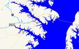
Maryland Route 70 is a 2.32 miles (3.7 km) state highway in Annapolis, Maryland
.
(College Avenue) in downtown Annapolis, following the dual Bladen Street at its southern beginning. After a few blocks, Rowe Boulevard merges into Bladen Street, and MD 70 assumes that name as it crosses the College Creek bridge. After it crosses Maryland Route 435
(Taylor Avenue), it passes by the Maryland District Court. Shortly after exiting Annapolis' corporate limits, MD 70 meets its interchange with the John Hanson Highway, which carries US 50
and 301
, along with Interstate 595. From the interchange, MD 70 continues for a short distance until it meets Bestgate Road. At this point, the MD 70 designation for the road ends, while the name of it changes to Bestgate Road, and turns west to parallel US 50 to the north.
MD 70's interchange with US 50
/US 301
marks the end of the unsigned Interstate 595
, which overlaps with US 50 between the Capital Beltway
(I-95
/I-495) and MD 70.
.
; it was changed to MD 464
by 1955. Today the road is part of MD 478
.
Despite the presence of Interstate 70 in Maryland
, the number has remained in use since its designation; other duplications between Interstate numbers and state route numbers also exist elsewhere in the state.
Annapolis, Maryland
Annapolis is the capital of the U.S. state of Maryland, as well as the county seat of Anne Arundel County. It had a population of 38,394 at the 2010 census and is situated on the Chesapeake Bay at the mouth of the Severn River, south of Baltimore and about east of Washington, D.C. Annapolis is...
.
Route description
Maryland Route 70 begins at an intersection with Maryland Route 450Maryland Route 450
Maryland Route 450 is a state highway in the U.S. state of Maryland. The state highway runs from U.S. Route 1 Alternate in Bladensburg east to US 50, US 301, and MD 2 near Annapolis. MD 450 is the original alignment of US 50 in Prince George's and Anne Arundel Counties...
(College Avenue) in downtown Annapolis, following the dual Bladen Street at its southern beginning. After a few blocks, Rowe Boulevard merges into Bladen Street, and MD 70 assumes that name as it crosses the College Creek bridge. After it crosses Maryland Route 435
Maryland Route 435
Maryland Route 435 is a state highway in the U.S. state of Maryland. The route runs between two different intersections with Maryland Route 450, one in western Annapolis and the other in northwestern Annapolis. As a result, MD 435 serves as a bypass of Downtown Annapolis...
(Taylor Avenue), it passes by the Maryland District Court. Shortly after exiting Annapolis' corporate limits, MD 70 meets its interchange with the John Hanson Highway, which carries US 50
U.S. Route 50 in Maryland
U.S. Route 50 is a major east–west route of the U.S. Highway system, stretching just over from Ocean City, Maryland on the Atlantic Ocean to West Sacramento, California. In the U.S. state of Maryland, US 50 exists in two sections. The longer of these serves as a major route connecting...
and 301
U.S. Route 301 in Maryland
U.S. Route 301 in Maryland is a major highway that runs from Delaware to the Governor Harry W. Nice Memorial Bridge into Virginia. It passes through three of Maryland's four main regions: the Eastern Shore, the Baltimore-Washington Metropolitan Area, and Southern Maryland...
, along with Interstate 595. From the interchange, MD 70 continues for a short distance until it meets Bestgate Road. At this point, the MD 70 designation for the road ends, while the name of it changes to Bestgate Road, and turns west to parallel US 50 to the north.
MD 70's interchange with US 50
U.S. Route 50 in Maryland
U.S. Route 50 is a major east–west route of the U.S. Highway system, stretching just over from Ocean City, Maryland on the Atlantic Ocean to West Sacramento, California. In the U.S. state of Maryland, US 50 exists in two sections. The longer of these serves as a major route connecting...
/US 301
U.S. Route 301 in Maryland
U.S. Route 301 in Maryland is a major highway that runs from Delaware to the Governor Harry W. Nice Memorial Bridge into Virginia. It passes through three of Maryland's four main regions: the Eastern Shore, the Baltimore-Washington Metropolitan Area, and Southern Maryland...
marks the end of the unsigned Interstate 595
Interstate 595 (Maryland)
Interstate 595 is an unsigned number for a section of the John Hanson Highway from Interstate 495 east of Washington, D.C. to Maryland Route 70 at Annapolis, Maryland....
, which overlaps with US 50 between the Capital Beltway
Interstate 495 (Capital Beltway)
Interstate 495 is a Interstate Highway that surrounds the United States' capital of Washington, D.C., and its inner suburbs in adjacent Maryland and Virginia. I-495 is widely known as the Capital Beltway or simply the Beltway, especially when the context of Washington, D.C., is clear...
(I-95
Interstate 95 in Maryland
Interstate 95 in Maryland is a major highway that runs diagonally from northeast to southwest, from Maryland's border with Delaware, to the Woodrow Wilson Bridge, briefly entering the District of Columbia before reaching Virginia...
/I-495) and MD 70.
Junction list
The entire route is in Anne Arundel CountyAnne Arundel County, Maryland
Anne Arundel County is a county located in the U.S. state of Maryland. It is named for Anne Arundell , a member of the ancient family of Arundells in Cornwall, England and the wife of Cæcilius Calvert, 2nd Baron Baltimore. Its county seat is Annapolis, which is also the capital of the state...
.
| Location | Mile | Destinations | Notes |
|---|---|---|---|
| Annapolis Annapolis, Maryland Annapolis is the capital of the U.S. state of Maryland, as well as the county seat of Anne Arundel County. It had a population of 38,394 at the 2010 census and is situated on the Chesapeake Bay at the mouth of the Severn River, south of Baltimore and about east of Washington, D.C. Annapolis is... |
0.00 | – St. John's College St. John's College, U.S. St. John's College is a liberal arts college with two U.S. campuses: one in Annapolis, Maryland and one in Santa Fe, New Mexico. Founded in 1696 as a preparatory school, King William's School, the school received a collegiate charter in 1784, making it one of the oldest institutions of higher... , U.S. Naval Academy |
Southern terminus |
| 0.79 | – Navy-Marine Corps Memorial Stadium Navy-Marine Corps Memorial Stadium Navy – Marine Corps Memorial Stadium is an outdoor athletic stadium near the campus of the U.S. Naval Academy in Annapolis, Maryland. It is the home field of the Navy Midshipmen football team, the men's lacrosse team, and the Chesapeake Bayhawks lacrosse team.... |
||
| 1.61 | – Washington D.C., Bay Bridge Chesapeake Bay Bridge The Chesapeake Bay Bridge is a major dual-span bridge in the U.S. state of Maryland. Spanning the Chesapeake Bay, it connects the state's rural Eastern Shore region with the more urban Western Shore. The original span opened in 1952 and, at the time, with a length of , it was the world's longest... |
Interchange | |
| 2.31 | Bestgate Road west | Northern terminus | |
History
The original MD 70 was part of Knoxville Road, in Frederick CountyFrederick County, Maryland
Frederick County is a county located in the western part of the U.S. state of Maryland, bordering the southern border of Pennsylvania and the northeastern border of Virginia. As of the 2010 Census, the population was 233,385....
; it was changed to MD 464
Maryland Route 464
Maryland Route 464 is a state highway in the U.S. state of Maryland. Known for most of its length as Point of Rocks Road, the state highway runs from MD 17 and MD 79 in Rosemont east to Ballenger Creek Pike in Point of Rocks. MD 464 connects Brunswick with U.S. Route 15 in Point of Rocks in...
by 1955. Today the road is part of MD 478
Maryland Route 478
Maryland Route 478 is a state highway in the U.S. state of Maryland. Known as Knoxville Road, the state highway runs from MD 180 in Knoxville east to Florida Avenue in Brunswick. MD 478 was constructed as MD 70 in the late 1920s. In 1950, MD 70 was replaced with an extended MD 464...
.
Despite the presence of Interstate 70 in Maryland
Interstate 70 in Maryland
Interstate 70 is a part of the Interstate Highway System that runs from Cove Fort, Utah to Baltimore, Maryland. In Maryland, the Interstate Highway runs from the Pennsylvania state line in Hancock east to the Interstate's eastern terminus near its junction with I-695 at a park and ride in...
, the number has remained in use since its designation; other duplications between Interstate numbers and state route numbers also exist elsewhere in the state.