
Maryland Route 30
Encyclopedia
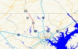
Maryland Route 30 is a 19.16 miles (30.83 km) state highway in Central Maryland region in the U.S. state
of Maryland
. It serves as one of the major north–south routes of central Maryland.
in northern Reisterstown. After intersecting with MD 128
the route runs north as a two-lane semi-rural country road. MD 30 intersects MD 91
in Fowblesburg before reaching Hampstead
in Carroll County
.
The Hampstead Bypass was recently opened for traffic on August 6, 2009, and now is the mainline routing for Maryland Route 30 in the town. The original alignment is now known as Maryland Route 30 Business and continues as Hampstead's Main Street. The need for the bypass was brought about due to the high levels of traffic and severe congestion that MD 30 experiences through Hampstead. The bypass skirts the west side of Hampstead, starting at a point on MD 30 slightly to the north of Wolf Hill Drive. The road is a total of 6 miles (9.7 km) long, and will not only have full access controls, but will also contain two grade separations - one at Houcksville Road and one at Shiloh Road. The bypass ends north of Hampstead, near Brodbeck Road, and includes three at-grade roundabouts—one at the southern terminus, with a spur to Wolf Hill Drive; one at MD 482
; and one at the northern terminus just to the south of Brodbeck Road. Original rights-of-way, such as Houcksville Road, were converted into frontage roads.
Beyond Hampstead, it resumes its Hanover Pike moniker and continues running northwest, meeting MD 27
in Manchester
. North of Manchester, MD 30 intersects MD 86
and MD 496
before continuing to the Pennsylvania
state line, where it becomes PA 94
.
The route is dotted with many small communities, neighborhoods and houses; traffic levels are therefore rather elevated, given the otherwise rural nature of the route. Traffic levels in Hampstead
and Manchester
are high and MD 30 through these towns is often congested and even halted due to the high levels of traffic.
!County
!Location
!Mile
!Destinations
!Notes
|-
|rowspan=8|Baltimore
|rowspan=3|Reisterstown
|0.00
|
|
|-
|0.39
|
|road west of intersection designated as MD 795; signed as MD 128
|-
|0.49
|Old Hanover Road north
|rowspan=3|former alignment of MD 30
|-
|
|1.16
|Old Hanover Rd. south
|-
|
|2.51-2.53
|Glen Falls Rd. west/Old Hanover Rd. east
|-
|rowspan=2|Fowblesburg
|5.20
|
|Emory Rd. continues to Old Hanover Rd.
|-
|5.30
|Old Hanover Rd. south
|former alignment of MD 30
|-
|
|6.28
|Bortner Rd. west/Dover Rd. east - to Trenton Rd.
|
|-
|rowspan=13|Carroll
|
|7.87
|
|Roundabout
, southern terminus of Hampstead Bypass
|-
|rowspan=2|Hampstead
|10.49
| – Mexico
|Roundabout
|-
|12.30
|
|Roundabout, northern terminus of Hampstead Bypass
|-
|
|13.19
|Cape Horn Rd. south - to Harvey Gummel Rd.
|
|-
|rowspan=4|Manchester
|rowspan=2|14.49
|York St. north - to Water Tank Rd.
|portion of York St. once part of both MD 27 and MD 31
|-
|
|former alignment of MD 27
|-
|14.72
|
|
|-
|15.90
| to PA 516
|-
|
|16.25
|
|
|-
|
|16.53
|
|
|-
|Melrose
|17.35
|
|MD 496 runs south of MD 30
|-
|
|17.98
|
|
|-
|
|19.16
|
|northern terminus of MD 30
|-
. It was created on August 6, 2009 along the former alignment of MD 30 through the town after MD 30 was relocated onto the Hampstead Bypass. The route is known as Main Street, a heavily congested arterial street, and intersects MD 88
and MD 482
in Hampstead.
U.S. state
A U.S. state is any one of the 50 federated states of the United States of America that share sovereignty with the federal government. Because of this shared sovereignty, an American is a citizen both of the federal entity and of his or her state of domicile. Four states use the official title of...
of Maryland
Maryland
Maryland is a U.S. state located in the Mid Atlantic region of the United States, bordering Virginia, West Virginia, and the District of Columbia to its south and west; Pennsylvania to its north; and Delaware to its east...
. It serves as one of the major north–south routes of central Maryland.
Route description
The route begins at a skewed intersection with MD 140Maryland Route 140
Maryland Route 140 is a local long route in northern Maryland, United States.-Route description:MD 140 is known by various names depending on location; south of Reisterstown it is known as Reisterstown Road. Though Reisterstown itself is named after John Reister, the road is named after Jacob...
in northern Reisterstown. After intersecting with MD 128
Maryland Route 128
Maryland Route 128, better known locally as Butler Road, is a road in Baltimore County, Maryland.-Route description:The road starts at the end of a spur of I-795 known as Maryland Route 795, where it intersects with Maryland Route 30 , and then passes to the east through historic Glyndon...
the route runs north as a two-lane semi-rural country road. MD 30 intersects MD 91
Maryland Route 91
Maryland Route 91 is a short highway that runs through central Maryland. It is one of only four routes still surviving in the route cluster assigned to Carroll County in the 1933 route numbering plan.-Counties traversed:*Carroll County*Baltimore County...
in Fowblesburg before reaching Hampstead
Hampstead, Maryland
Hampstead is a town in Carroll County in the U.S. state of Maryland. The population was 5,060 at the 2000 census. Hampstead School was listed on the National Register of Historic Places in 2002.-Geography:Hampstead is located at ....
in Carroll County
Carroll County, Maryland
Carroll County is a county located in the U.S. state of Maryland. In 2010, its population was 167,134. It was named for Charles Carroll of Carrollton , signer of the American Declaration of Independence. Its county seat is Westminster....
.
The Hampstead Bypass was recently opened for traffic on August 6, 2009, and now is the mainline routing for Maryland Route 30 in the town. The original alignment is now known as Maryland Route 30 Business and continues as Hampstead's Main Street. The need for the bypass was brought about due to the high levels of traffic and severe congestion that MD 30 experiences through Hampstead. The bypass skirts the west side of Hampstead, starting at a point on MD 30 slightly to the north of Wolf Hill Drive. The road is a total of 6 miles (9.7 km) long, and will not only have full access controls, but will also contain two grade separations - one at Houcksville Road and one at Shiloh Road. The bypass ends north of Hampstead, near Brodbeck Road, and includes three at-grade roundabouts—one at the southern terminus, with a spur to Wolf Hill Drive; one at MD 482
Maryland Route 482
Maryland Route 482 is a state highway in the U.S. state of Maryland. Known as Hampstead Mexico Road, the state highway runs from MD 27 in Mexico east to MD 30 Business in Hampstead. In conjunction with MD 27, MD 482 connects Westminster with Hampstead. The state highway was constructed at both...
; and one at the northern terminus just to the south of Brodbeck Road. Original rights-of-way, such as Houcksville Road, were converted into frontage roads.
Beyond Hampstead, it resumes its Hanover Pike moniker and continues running northwest, meeting MD 27
Maryland Route 27
Maryland Route 27 is a state highway in the central part of the U.S. state of Maryland.-Route description:MD 27, also known as Ridge Road and Manchester Road , begins in Germantown at MD 355...
in Manchester
Manchester, Maryland
Manchester, Maryland, is a small incorporated town in Northeastern Carroll County, Maryland located on the Eastern coast of the United States of America just South of the Pennsylvania State line and North of Baltimore, Maryland...
. North of Manchester, MD 30 intersects MD 86
Maryland Route 86
Maryland Route 86 is a state highway in the U.S. state of Maryland. Known as Lineboro Road, the state highway runs from MD 30 in Manchester north to the Pennsylvania state line in Lineboro, where the highway continues as Pennsylvania Route 516...
and MD 496
Maryland Route 496
Maryland Route 496 is a state highway in the U.S. state of Maryland. Known as Bachmans Valley Road, the state highway runs from MD 97 near Pleasant Valley east to MD 30 in Melrose. MD 496 was constructed from Pleasant Valley to Bachman Mills in the mid-1930s...
before continuing to the Pennsylvania
Pennsylvania
The Commonwealth of Pennsylvania is a U.S. state that is located in the Northeastern and Mid-Atlantic regions of the United States. The state borders Delaware and Maryland to the south, West Virginia to the southwest, Ohio to the west, New York and Ontario, Canada, to the north, and New Jersey to...
state line, where it becomes PA 94
Pennsylvania Route 94
Pennsylvania Route 94 is a 29 mile long north–south state highway located in southern Pennsylvania. The southern terminus of the route is at the Mason-Dixon Line, where PA 94 continues into Maryland as Maryland Route 30...
.
The route is dotted with many small communities, neighborhoods and houses; traffic levels are therefore rather elevated, given the otherwise rural nature of the route. Traffic levels in Hampstead
Hampstead, Maryland
Hampstead is a town in Carroll County in the U.S. state of Maryland. The population was 5,060 at the 2000 census. Hampstead School was listed on the National Register of Historic Places in 2002.-Geography:Hampstead is located at ....
and Manchester
Manchester, Maryland
Manchester, Maryland, is a small incorporated town in Northeastern Carroll County, Maryland located on the Eastern coast of the United States of America just South of the Pennsylvania State line and North of Baltimore, Maryland...
are high and MD 30 through these towns is often congested and even halted due to the high levels of traffic.
Junction list
{|class=wikitable!County
!Location
!Mile
!Destinations
!Notes
|-
|rowspan=8|Baltimore
Baltimore County, Maryland
Baltimore County is a county located in the northern part of the US state of Maryland. In 2010, its population was 805,029. It is part of the Baltimore-Washington Metropolitan Area. Its county seat is Towson. The name of the county was derived from the barony of the Proprietor of the Maryland...
|rowspan=3|Reisterstown
Reisterstown, Maryland
Reisterstown is an unincorporated community and census-designated place in Baltimore County, Maryland. Founded by German immigrant John Reister in 1758, it is located to the northwest of Baltimore. Though it is older than the areas surrounding it, it now serves primarily as a residential suburb of...
|0.00
|
|
|-
|0.39
|
|road west of intersection designated as MD 795; signed as MD 128
|-
|0.49
|Old Hanover Road north
|rowspan=3|former alignment of MD 30
|-
|
|1.16
|Old Hanover Rd. south
|-
|
|2.51-2.53
|Glen Falls Rd. west/Old Hanover Rd. east
|-
|rowspan=2|Fowblesburg
|5.20
|
|Emory Rd. continues to Old Hanover Rd.
|-
|5.30
|Old Hanover Rd. south
|former alignment of MD 30
|-
|
|6.28
|Bortner Rd. west/Dover Rd. east - to Trenton Rd.
|
|-
|rowspan=13|Carroll
Carroll County, Maryland
Carroll County is a county located in the U.S. state of Maryland. In 2010, its population was 167,134. It was named for Charles Carroll of Carrollton , signer of the American Declaration of Independence. Its county seat is Westminster....
|
|7.87
|
|Roundabout
Roundabout
A roundabout is the name for a road junction in which traffic moves in one direction around a central island. The word dates from the early 20th century. Roundabouts are common in many countries around the world...
, southern terminus of Hampstead Bypass
|-
|rowspan=2|Hampstead
Hampstead, Maryland
Hampstead is a town in Carroll County in the U.S. state of Maryland. The population was 5,060 at the 2000 census. Hampstead School was listed on the National Register of Historic Places in 2002.-Geography:Hampstead is located at ....
|10.49
| – Mexico
Mexico, Carroll County, Maryland
Mexico is an unincorporated community in Carroll County, Maryland. It lies at an elevation of 968 feet ....
|Roundabout
|-
|12.30
|
|Roundabout, northern terminus of Hampstead Bypass
|-
|
|13.19
|Cape Horn Rd. south - to Harvey Gummel Rd.
|
|-
|rowspan=4|Manchester
Manchester, Maryland
Manchester, Maryland, is a small incorporated town in Northeastern Carroll County, Maryland located on the Eastern coast of the United States of America just South of the Pennsylvania State line and North of Baltimore, Maryland...
|rowspan=2|14.49
|York St. north - to Water Tank Rd.
|portion of York St. once part of both MD 27 and MD 31
|-
|
|former alignment of MD 27
|-
|14.72
|
|
|-
|15.90
| to
PA 516Pennsylvania Route 516
Pennsylvania Route 516 is an long state highway located in York county in Pennsylvania. The southern terminus is the Maryland state line in Manheim Township. The northern terminus is at PA 116 in Spring Grove.-Route description:...
|-
|
|16.25
|
|
|-
|
|16.53
|
|
|-
|Melrose
|17.35
|
|MD 496 runs south of MD 30
|-
|
|17.98
|
|
|-
|
|19.16
|
|northern terminus of MD 30
|-
MD 30 Business
Maryland Route 30 Business is a 4 miles (6.4 km) business route of MD 30 through HampsteadHampstead, Maryland
Hampstead is a town in Carroll County in the U.S. state of Maryland. The population was 5,060 at the 2000 census. Hampstead School was listed on the National Register of Historic Places in 2002.-Geography:Hampstead is located at ....
. It was created on August 6, 2009 along the former alignment of MD 30 through the town after MD 30 was relocated onto the Hampstead Bypass. The route is known as Main Street, a heavily congested arterial street, and intersects MD 88
Maryland Route 88
Maryland Route 88 is a state highway in the U.S. state of Maryland, located in Carroll County and Baltimore County. It is a simple two-lane road, beginning at its western terminus at Main Street in Hampstead and ending at its eastern terminus at Falls Road in Butler.-Route description:Maryland...
and MD 482
Maryland Route 482
Maryland Route 482 is a state highway in the U.S. state of Maryland. Known as Hampstead Mexico Road, the state highway runs from MD 27 in Mexico east to MD 30 Business in Hampstead. In conjunction with MD 27, MD 482 connects Westminster with Hampstead. The state highway was constructed at both...
in Hampstead.