
Maribyrnong River Trail
Encyclopedia
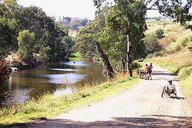
The Maribyrnong River Trail is a shared use path for cyclists
and pedestrian
s, which follows the Maribyrnong River
through the north western suburbs of Melbourne
, Victoria
, Australia
.
The path, often on both sides of the river, follows the meandering of the Maribyrnong River through a valley cut in the basaltic plateau in Keilor East
at Brimbank Park, then across a floodplain
to its entry into the Yarra River
at Docklands
.
Combined with the Taylors Creek Trail
this trail makes for an easy ride linking together the Footscray Road off-road path, Docklands and the Melbourne city centre
.
Starting at the north end of Brimbank Park, the gravel trail winds its way through the trees along the valley on the east side of the Maribyrnong River and the western end of the park. It passes under the towering EJ Whitten Bridge. Near the bridge base a steep path loops up to the same level as the bridge platform, where it connects to the Western Ring Road Trail
.
The path then proceeds through fantastic riverside parkland alongside suburbs such as North Sunshine and Maidstone
before reaching Canning Reserve in Avondale Heights
.
At Canning Reserve Tea Gardens at Avondale Heights the trail becomes concrete and remains concrete for the next 6 km to Footscray
. On the weekends the smell of barbecues fills the air, with picnickers dotted along the length of the river, children enjoying playgrounds or water games. The path splits into a concrete path that follows a minor creek valley up into Avondale Heights to Monte Carlo Drive Reserve. The main trail, a gravel path, continues along the river.
Near the confluence of Maribyrnong River and Steele Creek at Essendon West
the path becomes concrete and follows Steele creek inland before winding up the hillside to the top of the plateau at Lily St for outstanding views of the Maribyrnong River and the skyscraper
s of the Melbourne CBD in the distance. Care needs to be taken crossing Buckley Street if turning off to Steele Creek Trail
that connects at this point.
The path enters a switch back section that winds back down to the river. Further is Afton Street footbridge (a cream coloured bridge). The trail now runs down both banks of the river. Do not continue down the east side of the river any further than the Pipemakers Park footbridge (a red coloured bridge at Newsom Street) (as of 2009 this bridge is closed for repairs), as further south the path runs out. Cross the bridge to Pipemakers Park.
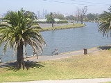
At Maribyrnong
the path passes through Pipemakers Park with its Living Museum of the West which contains historical presentations on the river valley and the people who have lived there since its initial occupation up to 40,000 years ago by the Wurundjeri
people.
The path passes Flemington Racecourse
, where the Melbourne Cup
is run on the first Tuesday of November each year as part of the Spring Racing Carnival.
, Brimbank Park, Horseshoe Bend Children's farm, Pipemakers Park, Canning Reserve, Burndap Park, Thompson Street Reserve, 16m Mazu
statue, Newells Paddock Wetlands Park.
connects with the Maribyrnong River Trail at the south end of Brimbank Park.
It connects to the Steele Creek Trail
on the north side of Buckley Street. Use the Buckley Street underpass just west of Lily Street.
At Footscray
, where Footscray Road crosses the Maribyrnong River
over Shepherd Bridge, the trail splits in two. One path becomes the Hobsons Bay Coastal Trail
. The other is a 2.8 km path, running along the south side of Footscray Road, which connects to the Capital City Trail
.
On weekends, on the Hobsons Bay Coastal Trail
, a punt
takes cyclists across the Yarra River under the West Gate Bridge
at Spotswood
near the Scienceworks Museum
.
A 3 km road section connects with Taylors Creek Trail
in the north west. From the north end of Brimbank Park head north on Green Gully Road using the east side service road and then west on the Old Calder Highway using the service road on its south side. At the point where the Old Calder Highway and the Calder Freeway become close to each other, is a side street to the left (west), called Burrowye Crescent. The Taylors Creek Trail
starts 500m down Burrowye Crescent on the right.
North end at 37.727171°S 144.835248°E.
South end at 37.806250°S 144.906886°E.
Cycling
Cycling, also called bicycling or biking, is the use of bicycles for transport, recreation, or for sport. Persons engaged in cycling are cyclists or bicyclists...
and pedestrian
Pedestrian
A pedestrian is a person traveling on foot, whether walking or running. In some communities, those traveling using roller skates or skateboards are also considered to be pedestrians. In modern times, the term mostly refers to someone walking on a road or footpath, but this was not the case...
s, which follows the Maribyrnong River
Maribyrnong river
The Maribyrnong River rises about 50 km north of Melbourne, Victoria , near Mount Macedon. It flows generally southward and combines with the Yarra River to flow into Port Phillip....
through the north western suburbs of Melbourne
Melbourne
Melbourne is the capital and most populous city in the state of Victoria, and the second most populous city in Australia. The Melbourne City Centre is the hub of the greater metropolitan area and the Census statistical division—of which "Melbourne" is the common name. As of June 2009, the greater...
, Victoria
Victoria (Australia)
Victoria is the second most populous state in Australia. Geographically the smallest mainland state, Victoria is bordered by New South Wales, South Australia, and Tasmania on Boundary Islet to the north, west and south respectively....
, Australia
Australia
Australia , officially the Commonwealth of Australia, is a country in the Southern Hemisphere comprising the mainland of the Australian continent, the island of Tasmania, and numerous smaller islands in the Indian and Pacific Oceans. It is the world's sixth-largest country by total area...
.
The path, often on both sides of the river, follows the meandering of the Maribyrnong River through a valley cut in the basaltic plateau in Keilor East
Keilor East, Victoria
Keilor East is a suburb in Melbourne, Victoria, Australia, 16 km north-west from Melbourne's central business district. Its Local Government Area are the Cities of Brimbank and Moonee Valley...
at Brimbank Park, then across a floodplain
Floodplain
A floodplain, or flood plain, is a flat or nearly flat land adjacent a stream or river that stretches from the banks of its channel to the base of the enclosing valley walls and experiences flooding during periods of high discharge...
to its entry into the Yarra River
Yarra River
The Yarra River, originally Birrarung, is a river in east-central Victoria, Australia. The lower stretches of the river is where the city of Melbourne was established in 1835 and today Greater Melbourne dominates and influences the landscape of its lower reaches...
at Docklands
Melbourne Docklands
Docklands is an inner city suburb in Melbourne, Victoria, Australia occupying an area extending up to 2 km west of and adjacent to Melbourne's Central Business District . Its Local Government Area is the City of Melbourne...
.
Combined with the Taylors Creek Trail
Taylors Creek Trail
The Taylors Creek Trail is a shared use path for cyclists and pedestrians, which follows Taylors Creek in the outer north suburb of Taylors Lakes in Melbourne, Victoria, Australia....
this trail makes for an easy ride linking together the Footscray Road off-road path, Docklands and the Melbourne city centre
Melbourne city centre
Melbourne City Centre is an area of Melbourne in Victoria, Australia. It is not to be confused with the larger local government area of the City of Melbourne...
.
Partial closure due to flood damage
October 2011: The Maribyrnong River Trail from Brimbank Park into the CBD has been closed between Brimbank Park and roughly the Canning Street Park since about May 2011 due to flood damage.Starting at the north end of Brimbank Park, the gravel trail winds its way through the trees along the valley on the east side of the Maribyrnong River and the western end of the park. It passes under the towering EJ Whitten Bridge. Near the bridge base a steep path loops up to the same level as the bridge platform, where it connects to the Western Ring Road Trail
Western Ring Road Trail
The Western Ring Road Trail is a shared use path for cyclists and pedestrians that bridges the northern suburbs and follows the Western Ring Road...
.
The path then proceeds through fantastic riverside parkland alongside suburbs such as North Sunshine and Maidstone
Maidstone, Victoria
Maidstone is a suburb 8 km west of Melbourne, Victoria, Australia. Its Local Government Area is the City of Maribyrnong. At the 2006 Census, Maidstone had a population of 6050....
before reaching Canning Reserve in Avondale Heights
Avondale Heights, Victoria
Avondale Heights is a suburb 12 km north-west of Melbourne, Victoria, Australia. Its Local Government Area is the City of Moonee Valley. At the 2006 Census, Avondale Heights had a population of 11,074....
.
At Canning Reserve Tea Gardens at Avondale Heights the trail becomes concrete and remains concrete for the next 6 km to Footscray
Footscray, Victoria
Footscray is a suburb 5 km west of Melbourne, Victoria, Australia. Its Local Government Area is the City of Maribyrnong. At the 2006 Census, Footscray had a population of 11,401....
. On the weekends the smell of barbecues fills the air, with picnickers dotted along the length of the river, children enjoying playgrounds or water games. The path splits into a concrete path that follows a minor creek valley up into Avondale Heights to Monte Carlo Drive Reserve. The main trail, a gravel path, continues along the river.
Near the confluence of Maribyrnong River and Steele Creek at Essendon West
Essendon West, Victoria
Essendon West is a suburb in Melbourne, Victoria, Australia, 11 km north-west from Melbourne's central business district. Its Local Government Area is the City of Moonee Valley...
the path becomes concrete and follows Steele creek inland before winding up the hillside to the top of the plateau at Lily St for outstanding views of the Maribyrnong River and the skyscraper
Skyscraper
A skyscraper is a tall, continuously habitable building of many stories, often designed for office and commercial use. There is no official definition or height above which a building may be classified as a skyscraper...
s of the Melbourne CBD in the distance. Care needs to be taken crossing Buckley Street if turning off to Steele Creek Trail
Steele Creek Trail
The Steele Creek Trail is a shared use path for cyclists and pedestrians, which follows Steele Creek in the inner northern suburb of Keilor East in Melbourne, Victoria, Australia....
that connects at this point.
The path enters a switch back section that winds back down to the river. Further is Afton Street footbridge (a cream coloured bridge). The trail now runs down both banks of the river. Do not continue down the east side of the river any further than the Pipemakers Park footbridge (a red coloured bridge at Newsom Street) (as of 2009 this bridge is closed for repairs), as further south the path runs out. Cross the bridge to Pipemakers Park.
At Maribyrnong
Maribyrnong, Victoria
Maribyrnong is a suburb 8 km north-west of Melbourne, Victoria, Australia. Its Local Government Area is the City of Maribyrnong, part of River Ward. At the 2006 Census, Maribyrnong had a population of 8242....
the path passes through Pipemakers Park with its Living Museum of the West which contains historical presentations on the river valley and the people who have lived there since its initial occupation up to 40,000 years ago by the Wurundjeri
Wurundjeri
The Wurundjeri are a people of the Indigenous Australian nation of the Woiwurrung language group, in the Kulin alliance, who occupy the Birrarung Valley, its tributaries and the present location of Melbourne, Australia...
people.
The path passes Flemington Racecourse
Flemington Racecourse
Flemington Racecourse is a major horse racing venue located in Melbourne, Victoria, Australia. It is most notable for hosting the Melbourne Cup, which is Australia's richest horse race. The racecourse is situated on low alluvial flats, next to the Maribyrnong River...
, where the Melbourne Cup
Melbourne Cup
The Melbourne Cup is Australia's major Thoroughbred horse race. Marketed as "the race that stops a nation", it is a 3,200 metre race for three-year-olds and over. It is the richest "two-mile" handicap in the world, and one of the richest turf races...
is run on the first Tuesday of November each year as part of the Spring Racing Carnival.
Landmarks
Maribyrnong RiverMaribyrnong river
The Maribyrnong River rises about 50 km north of Melbourne, Victoria , near Mount Macedon. It flows generally southward and combines with the Yarra River to flow into Port Phillip....
, Brimbank Park, Horseshoe Bend Children's farm, Pipemakers Park, Canning Reserve, Burndap Park, Thompson Street Reserve, 16m Mazu
Matsu (goddess)
Mazu , also spelt Matsu, is the indigenous goddess of the sea who is said to protect fishermen and sailors, and is invoked as the patron deity of all Southern Chinese and East Asian persons...
statue, Newells Paddock Wetlands Park.
Connections
The Western Ring Road TrailWestern Ring Road Trail
The Western Ring Road Trail is a shared use path for cyclists and pedestrians that bridges the northern suburbs and follows the Western Ring Road...
connects with the Maribyrnong River Trail at the south end of Brimbank Park.
It connects to the Steele Creek Trail
Steele Creek Trail
The Steele Creek Trail is a shared use path for cyclists and pedestrians, which follows Steele Creek in the inner northern suburb of Keilor East in Melbourne, Victoria, Australia....
on the north side of Buckley Street. Use the Buckley Street underpass just west of Lily Street.
At Footscray
Footscray, Victoria
Footscray is a suburb 5 km west of Melbourne, Victoria, Australia. Its Local Government Area is the City of Maribyrnong. At the 2006 Census, Footscray had a population of 11,401....
, where Footscray Road crosses the Maribyrnong River
Maribyrnong river
The Maribyrnong River rises about 50 km north of Melbourne, Victoria , near Mount Macedon. It flows generally southward and combines with the Yarra River to flow into Port Phillip....
over Shepherd Bridge, the trail splits in two. One path becomes the Hobsons Bay Coastal Trail
Hobsons Bay Coastal Trail
The Hobsons Bay Coastal Trail is a shared use path for cyclists and pedestrians, which follows the coast line of Hobsons Bay in the inner western suburbs in Melbourne, Victoria, Australia. The trail forms part of the western half of the Bayside Trail which encircles Port Phillip...
. The other is a 2.8 km path, running along the south side of Footscray Road, which connects to the Capital City Trail
Capital City Trail
The Capital City Trail is a shared use path for cyclists and pedestrians, which circles the Melbourne city centre and some inner eastern and northern suburbs of Melbourne, Victoria, Australia....
.
On weekends, on the Hobsons Bay Coastal Trail
Hobsons Bay Coastal Trail
The Hobsons Bay Coastal Trail is a shared use path for cyclists and pedestrians, which follows the coast line of Hobsons Bay in the inner western suburbs in Melbourne, Victoria, Australia. The trail forms part of the western half of the Bayside Trail which encircles Port Phillip...
, a punt
Punt (boat)
A punt is a flat-bottomed boat with a square-cut bow, designed for use in small rivers or other shallow water. Punting refers to boating in a punt. The punter generally propels the punt by pushing against the river bed with a pole...
takes cyclists across the Yarra River under the West Gate Bridge
West Gate Bridge
The West Gate Bridge is a steel box girder cable-stayed bridge in Melbourne, Victoria, Australia. It spans the Yarra River, just north of its mouth into Port Phillip, and is a vital link between the inner city and Melbourne's western suburbs with the industrial suburbs in the west and with the city...
at Spotswood
Spotswood, Victoria
Spotswood is a suburb in Melbourne, Victoria, Australia, 7 km south-west from Melbourne's central business district. Its Local Government Area is the City of Hobsons Bay...
near the Scienceworks Museum
Scienceworks Museum (Melbourne)
Scienceworks is a world renowned science museum in Melbourne, Australia. It is a venue of Museum Victoria which administers the cultural and scientific collections of the State of Victoria...
.
A 3 km road section connects with Taylors Creek Trail
Taylors Creek Trail
The Taylors Creek Trail is a shared use path for cyclists and pedestrians, which follows Taylors Creek in the outer north suburb of Taylors Lakes in Melbourne, Victoria, Australia....
in the north west. From the north end of Brimbank Park head north on Green Gully Road using the east side service road and then west on the Old Calder Highway using the service road on its south side. At the point where the Old Calder Highway and the Calder Freeway become close to each other, is a side street to the left (west), called Burrowye Crescent. The Taylors Creek Trail
Taylors Creek Trail
The Taylors Creek Trail is a shared use path for cyclists and pedestrians, which follows Taylors Creek in the outer north suburb of Taylors Lakes in Melbourne, Victoria, Australia....
starts 500m down Burrowye Crescent on the right.
North end at 37.727171°S 144.835248°E.
South end at 37.806250°S 144.906886°E.
External links
- Maribyrnong Bike User Group (MAZZA BUG) - Often organise rides around the Maribyrnong Trail.
- Bicycle Victoria on the Maribyrnong Trail.
- Yarra punt
- Brimbank Park