
Avondale Heights, Victoria
Encyclopedia
Avondale Heights is a suburb 12 km north-west of Melbourne
, Victoria
, Australia
. Its Local Government Area is the City of Moonee Valley
. At the 2006 Census, Avondale Heights had a population of 11,074.
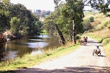
Avondale Heights is located on a plateau bounded by a large bend of the Maribyrnong River
to the east, south, and west, and to the north by Buckley Street.
The suburb derives its name from the Avondale Estate. Originally known as Maribyrnong West, when the Council undertook to change the name, postal authorities drew attention to the existence of Avondale in Queensland
. The suburb was therefore called Avondale Heights to distinguish it from the Queensland town.
There is only one main road - Military Road which runs from Canning Street and Maribyrnong Road, then becomes Milleara Road. There are about 40 shops at the Canning Street end (including Raglan street) and 20 at the other end, near the St Martin De Porres Primary School.
Aboriginal
people of the Kulin
nation moved through the area. Evidence has been found of human occupation for at least 18,000 years. On 10 October 1940, Mr. James White dug up an ancient human skull, (now known as the Keilor Cranium) on the banks of the Maribyrnong River. This skull has been found to be more than 8,000 years and less than 15,800 years old.
In 1803 Charles Grimes
, the New South Wales Surveyor General, sailed up the Yarra River
in the Buffalo and sent a rowing boat to explore the 'Saltwater River', as the Maribyrnong was then called. The rowing boat reached a place now known as Solomon's Ford, and could go no further.
In 1835 with the initial settlement of Melbourne, Edmund Davis Fergusson and Michael Solomon established a pastoral holding in the Avondale Sunshine area. On Solomon's sheep station the ford now near the west end of Canning Street soon became known as Solomon's Ford. This was the lowest crossing point on the Saltwater (Maribyrnong) River, and was for many years the only way from Melbourne to Geelong and further west.
During World War I the Canning Street bridge was known as Cordite Bridge as it led to the Department of Defence Explosives Factory. A password was necessary to cross the bridge during the war. During World War II a night curfew was imposed on the river and a boom was put into place to hinder access.
During the 1930s the district was subdivided into small dairy and cattle farms, with some poultry farming. Even into the 1960s market gardens and small dairy farms operated in the area. In the late 1960s housing development changed the area into a residential suburb with views of Melbourne city from the plateau. Avondale Heights Post Office opened on 9 December 1957 as the suburb developed. (A Maribyrnong West office had been open between 1943 and 1947).
In 2008 Avondale Heights is set to experience its largest urbanisation initiative since the formation of the area as a suburb. This is due to the intended sale of the old Kangan Batman Tafe site to private investors to develop median density residential housing.
Recreational and commuter cyclists have easy access to the Maribyrnong River Trail
along the Maribyrnong River
.
There is no tram route through Avondale Heights - the closest ends in Maribyrnong
. An extension of the tram route from Highpoint Shopping Centre
Precinct via Avondale Heights to East Keilor has been proposed by the Victorian Greens
.
.
Avondale Heights Soccer Club
Melbourne
Melbourne is the capital and most populous city in the state of Victoria, and the second most populous city in Australia. The Melbourne City Centre is the hub of the greater metropolitan area and the Census statistical division—of which "Melbourne" is the common name. As of June 2009, the greater...
, Victoria
Victoria (Australia)
Victoria is the second most populous state in Australia. Geographically the smallest mainland state, Victoria is bordered by New South Wales, South Australia, and Tasmania on Boundary Islet to the north, west and south respectively....
, Australia
Australia
Australia , officially the Commonwealth of Australia, is a country in the Southern Hemisphere comprising the mainland of the Australian continent, the island of Tasmania, and numerous smaller islands in the Indian and Pacific Oceans. It is the world's sixth-largest country by total area...
. Its Local Government Area is the City of Moonee Valley
City of Moonee Valley
The City of Moonee Valley is a Local Government Area located within the metropolitan area of Melbourne, Victoria, Australia. It comprises the north-western suburbs between 3 and 13 kilometres from the Melbourne city centre...
. At the 2006 Census, Avondale Heights had a population of 11,074.
Avondale Heights is located on a plateau bounded by a large bend of the Maribyrnong River
Maribyrnong river
The Maribyrnong River rises about 50 km north of Melbourne, Victoria , near Mount Macedon. It flows generally southward and combines with the Yarra River to flow into Port Phillip....
to the east, south, and west, and to the north by Buckley Street.
The suburb derives its name from the Avondale Estate. Originally known as Maribyrnong West, when the Council undertook to change the name, postal authorities drew attention to the existence of Avondale in Queensland
Queensland
Queensland is a state of Australia, occupying the north-eastern section of the mainland continent. It is bordered by the Northern Territory, South Australia and New South Wales to the west, south-west and south respectively. To the east, Queensland is bordered by the Coral Sea and Pacific Ocean...
. The suburb was therefore called Avondale Heights to distinguish it from the Queensland town.
There is only one main road - Military Road which runs from Canning Street and Maribyrnong Road, then becomes Milleara Road. There are about 40 shops at the Canning Street end (including Raglan street) and 20 at the other end, near the St Martin De Porres Primary School.
History
Prior to European colonisation of Melbourne, the WurundjeriWurundjeri
The Wurundjeri are a people of the Indigenous Australian nation of the Woiwurrung language group, in the Kulin alliance, who occupy the Birrarung Valley, its tributaries and the present location of Melbourne, Australia...
Aboriginal
Indigenous Australians
Indigenous Australians are the original inhabitants of the Australian continent and nearby islands. The Aboriginal Indigenous Australians migrated from the Indian continent around 75,000 to 100,000 years ago....
people of the Kulin
Kulin
The Kulin nation, was an alliance of five Indigenous Australian nations in Central Victoria, Australia, prior to European settlement. Their collective territory extended to around Port Phillip and Western Port, up into the Great Dividing Range and the Loddon and Goulburn River valleys. To their...
nation moved through the area. Evidence has been found of human occupation for at least 18,000 years. On 10 October 1940, Mr. James White dug up an ancient human skull, (now known as the Keilor Cranium) on the banks of the Maribyrnong River. This skull has been found to be more than 8,000 years and less than 15,800 years old.
In 1803 Charles Grimes
Charles Grimes
Charles Grimes was an English-born surveyor who did some valuable work in colonial Australia. He served as surveyor-general of New South Wales and discovered the Yarra River in what is now the state of Victoria. He is perhaps best known for being the surveyor who mapped the route of the Hobart...
, the New South Wales Surveyor General, sailed up the Yarra River
Yarra River
The Yarra River, originally Birrarung, is a river in east-central Victoria, Australia. The lower stretches of the river is where the city of Melbourne was established in 1835 and today Greater Melbourne dominates and influences the landscape of its lower reaches...
in the Buffalo and sent a rowing boat to explore the 'Saltwater River', as the Maribyrnong was then called. The rowing boat reached a place now known as Solomon's Ford, and could go no further.
In 1835 with the initial settlement of Melbourne, Edmund Davis Fergusson and Michael Solomon established a pastoral holding in the Avondale Sunshine area. On Solomon's sheep station the ford now near the west end of Canning Street soon became known as Solomon's Ford. This was the lowest crossing point on the Saltwater (Maribyrnong) River, and was for many years the only way from Melbourne to Geelong and further west.
During World War I the Canning Street bridge was known as Cordite Bridge as it led to the Department of Defence Explosives Factory. A password was necessary to cross the bridge during the war. During World War II a night curfew was imposed on the river and a boom was put into place to hinder access.
During the 1930s the district was subdivided into small dairy and cattle farms, with some poultry farming. Even into the 1960s market gardens and small dairy farms operated in the area. In the late 1960s housing development changed the area into a residential suburb with views of Melbourne city from the plateau. Avondale Heights Post Office opened on 9 December 1957 as the suburb developed. (A Maribyrnong West office had been open between 1943 and 1947).
In 2008 Avondale Heights is set to experience its largest urbanisation initiative since the formation of the area as a suburb. This is due to the intended sale of the old Kangan Batman Tafe site to private investors to develop median density residential housing.
Transport
Four bus routes service the suburb:- 406 FootscrayFootscray, VictoriaFootscray is a suburb 5 km west of Melbourne, Victoria, Australia. Its Local Government Area is the City of Maribyrnong. At the 2006 Census, Footscray had a population of 11,401....
– East KeilorKeilor East, VictoriaKeilor East is a suburb in Melbourne, Victoria, Australia, 16 km north-west from Melbourne's central business district. Its Local Government Area are the Cities of Brimbank and Moonee Valley...
via Victoria University, Highpoint SC, Avondale Heights (every day). Operated by WestransWestransWestrans is the brand under which ComfortDelGro Cabcharge markets its bus services to the western suburbs of Melbourne, Victoria, Australia.-Routes:Routes operated under Westrans Sunshine...
. - 407 Highpoint SCHighpoint Shopping CentreHighpoint Shopping Centre is a major shopping centre located in Maribyrnong, Victoria, in the western suburbs of Melbourne, Victoria, Australia. The centre has over 400 stores including a four-level Myer department store, Target, Big W, Harris Scarfe, Safeway supermarket, Best and Less, Rebel...
– Avondale HeightsAvondale Heights, VictoriaAvondale Heights is a suburb 12 km north-west of Melbourne, Victoria, Australia. Its Local Government Area is the City of Moonee Valley. At the 2006 Census, Avondale Heights had a population of 11,074....
via Milleara Mall SC (Monday to Saturday). Operated by WestransWestransWestrans is the brand under which ComfortDelGro Cabcharge markets its bus services to the western suburbs of Melbourne, Victoria, Australia.-Routes:Routes operated under Westrans Sunshine...
. - 465 EssendonEssendon, VictoriaEssendon is a suburb in Melbourne, Victoria, Australia, 10 km north-west from Melbourne's central business district. Its Local Government Area is the City of Moonee Valley...
– Keilor ParkKeilor Park, VictoriaKeilor Park is a suburb 17 km north-west of Melbourne, Victoria, Australia. Its Local Government Area is the City of Brimbank. At the 2006 Census, Keilor Park had a population of 2638....
via Buckley Street, Milleara SC, Keilor East (every day). Operated by Ryan Brothers Bus Service. - 903 AltonaAltona, VictoriaAltona is a suburb in Melbourne, Victoria, Australia, 13 km south-west from Melbourne's central business district. Its Local Government Area is the City of Hobsons Bay. At the 2006 Census, Altona had a population of 9685....
– Mordialloc SC via Essendon, Northland SC, Box Hill, Chadstone SC (every day). Operated by Ventura Bus LinesVentura Bus LinesVentura is a privately owned bus and coach operator in Melbourne, Victoria, Australia. Today the largest private Melbourne bus company, and operates a number of bus routes under contract from the Victorian State Government. The company purchased National Bus Company for A$45 million, and the Mount...
and WestransWestransWestrans is the brand under which ComfortDelGro Cabcharge markets its bus services to the western suburbs of Melbourne, Victoria, Australia.-Routes:Routes operated under Westrans Sunshine...
.
Recreational and commuter cyclists have easy access to the Maribyrnong River Trail
Maribyrnong River Trail
The Maribyrnong River Trail is a shared use path for cyclists and pedestrians, which follows the Maribyrnong River through the north western suburbs of Melbourne, Victoria, Australia....
along the Maribyrnong River
Maribyrnong river
The Maribyrnong River rises about 50 km north of Melbourne, Victoria , near Mount Macedon. It flows generally southward and combines with the Yarra River to flow into Port Phillip....
.
There is no tram route through Avondale Heights - the closest ends in Maribyrnong
Maribyrnong, Victoria
Maribyrnong is a suburb 8 km north-west of Melbourne, Victoria, Australia. Its Local Government Area is the City of Maribyrnong, part of River Ward. At the 2006 Census, Maribyrnong had a population of 8242....
. An extension of the tram route from Highpoint Shopping Centre
Highpoint Shopping Centre
Highpoint Shopping Centre is a major shopping centre located in Maribyrnong, Victoria, in the western suburbs of Melbourne, Victoria, Australia. The centre has over 400 stores including a four-level Myer department store, Target, Big W, Harris Scarfe, Safeway supermarket, Best and Less, Rebel...
Precinct via Avondale Heights to East Keilor has been proposed by the Victorian Greens
Victorian Greens
Australian Greens Victoria, also called the Victorian Greens, is a Green Party located in Victoria, a member of the federation of the Australian Greens party.- Early Years :...
.
Sport
Avondale Heights has an Australian Rules football team playing in the Essendon District Football LeagueEssendon District Football League
The Essendon District Football League is an Australian rules football league based in the north-west suburbs of Melbourne, which was established in 1930.The EDFL consists of 24 senior clubs, 10 clubs in A Grade and 14 clubs in B Grade...
.
Avondale Heights Soccer Club
Notable residents
- Matthew LloydMatthew LloydMatthew James Lloyd is a former Australian rules footballer who played for and was the captain of the Essendon Football Club in the Australian Football League...
, Ex AFL footballer, EssendonEssendon Football ClubThe Essendon Football Club, nicknamed The Bombers, is an Australian rules football club which plays in the Australian Football League... - Frederick Valentich who disappeared in the apparent UFO incident over Bass Strait in 1978
See also
- City of KeilorCity of KeilorThe City of Keilor was a Local Government Area located about northwest of Melbourne, the state capital of Victoria, Australia. The city covered an area of , and existed from 1863 until 1994.-History:...
- the former local government area of which Avondale Heights was a part.