
Hobsons Bay Coastal Trail
Encyclopedia
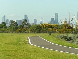
The Hobsons Bay Coastal Trail is a shared use path for cyclists and pedestrians, which follows the coast line of Hobsons Bay
in the inner western suburbs in Melbourne
, Victoria
, Australia. The trail forms part of the western half of the Bayside Trail which encircles Port Phillip
. It runs from the west side of the Westgate bridge, south and along the coast, finishing at the Skeleton Creek Trail in Sanctuary Lakes.
end the path connects with the Maribyrnong River Trail
and passes the offices of the Lonely Planet
publications. At this junction cyclists can continue north on the Maribyrnong River Trail
or connect to the Footscray Road off-road path which continues directly to the Docklands and the Capital City Trail
.
Between Footscray and Spotswood
the 3m wide off road path is new (opened in October 2009) and continues south down Moreland Street, Whitehall Street before turning west down Somerville Road and then south again down Hyde Street for approximately 1 kilometre. Under the West Gate Bridge
the 3 metre trail continues south along the banks of the Yarra River for approximately 3 km to Williamstown
. From here continuous paths can be followed to Altona
.
On weekends a punt
takes cyclists across the Yarra River from Spotswood near the Scienceworks Museum
.
 In the north is the Maribyrnong River Trail
as well as the Footscray Road Path which connects to the Capital City Trail
in Docklands. Heading south the trail goes through Williamstown
and intersects the lower Kororoit Creek Trail
in Altona
, then the Laverton Creek Trail
. In the south the path terminates at the Skeleton Creek Trail
in Altona Meadows
.
Hobsons Bay
Hobsons Bay is a bay in Port Phillip, Victoria, Australia....
in the inner western suburbs in Melbourne
Melbourne
Melbourne is the capital and most populous city in the state of Victoria, and the second most populous city in Australia. The Melbourne City Centre is the hub of the greater metropolitan area and the Census statistical division—of which "Melbourne" is the common name. As of June 2009, the greater...
, Victoria
Victoria (Australia)
Victoria is the second most populous state in Australia. Geographically the smallest mainland state, Victoria is bordered by New South Wales, South Australia, and Tasmania on Boundary Islet to the north, west and south respectively....
, Australia. The trail forms part of the western half of the Bayside Trail which encircles Port Phillip
Port Phillip
Port Phillip Port Phillip Port Phillip (also commonly referred to as Port Phillip Bay or (locally) just The Bay, is a large bay in southern Victoria, Australia; it is the location of Melbourne. Geographically, the bay covers and the shore stretches roughly . Although it is extremely shallow for...
. It runs from the west side of the Westgate bridge, south and along the coast, finishing at the Skeleton Creek Trail in Sanctuary Lakes.
Following the Path
Towards the FootscrayFootscray, Victoria
Footscray is a suburb 5 km west of Melbourne, Victoria, Australia. Its Local Government Area is the City of Maribyrnong. At the 2006 Census, Footscray had a population of 11,401....
end the path connects with the Maribyrnong River Trail
Maribyrnong River Trail
The Maribyrnong River Trail is a shared use path for cyclists and pedestrians, which follows the Maribyrnong River through the north western suburbs of Melbourne, Victoria, Australia....
and passes the offices of the Lonely Planet
Lonely Planet
Lonely Planet is the largest travel guide book and digital media publisher in the world. The company is owned by BBC Worldwide, which bought a 75% share from the founders Maureen and Tony Wheeler in 2007 and the final 25% in February 2011...
publications. At this junction cyclists can continue north on the Maribyrnong River Trail
Maribyrnong River Trail
The Maribyrnong River Trail is a shared use path for cyclists and pedestrians, which follows the Maribyrnong River through the north western suburbs of Melbourne, Victoria, Australia....
or connect to the Footscray Road off-road path which continues directly to the Docklands and the Capital City Trail
Capital City Trail
The Capital City Trail is a shared use path for cyclists and pedestrians, which circles the Melbourne city centre and some inner eastern and northern suburbs of Melbourne, Victoria, Australia....
.
Between Footscray and Spotswood
Spotswood, Victoria
Spotswood is a suburb in Melbourne, Victoria, Australia, 7 km south-west from Melbourne's central business district. Its Local Government Area is the City of Hobsons Bay...
the 3m wide off road path is new (opened in October 2009) and continues south down Moreland Street, Whitehall Street before turning west down Somerville Road and then south again down Hyde Street for approximately 1 kilometre. Under the West Gate Bridge
West Gate Bridge
The West Gate Bridge is a steel box girder cable-stayed bridge in Melbourne, Victoria, Australia. It spans the Yarra River, just north of its mouth into Port Phillip, and is a vital link between the inner city and Melbourne's western suburbs with the industrial suburbs in the west and with the city...
the 3 metre trail continues south along the banks of the Yarra River for approximately 3 km to Williamstown
Williamstown, Victoria
Williamstown is a suburb in Melbourne, Victoria, Australia, 8 km south-west from Melbourne's central business district. Its Local Government Area is the City of Hobsons Bay. At the 2006 Census, Williamstown had a population of 12,733....
. From here continuous paths can be followed to Altona
Altona, Victoria
Altona is a suburb in Melbourne, Victoria, Australia, 13 km south-west from Melbourne's central business district. Its Local Government Area is the City of Hobsons Bay. At the 2006 Census, Altona had a population of 9685....
.
On weekends a punt
Punt (boat)
A punt is a flat-bottomed boat with a square-cut bow, designed for use in small rivers or other shallow water. Punting refers to boating in a punt. The punter generally propels the punt by pushing against the river bed with a pole...
takes cyclists across the Yarra River from Spotswood near the Scienceworks Museum
Scienceworks Museum (Melbourne)
Scienceworks is a world renowned science museum in Melbourne, Australia. It is a venue of Museum Victoria which administers the cultural and scientific collections of the State of Victoria...
.
Connections
Maribyrnong River Trail
The Maribyrnong River Trail is a shared use path for cyclists and pedestrians, which follows the Maribyrnong River through the north western suburbs of Melbourne, Victoria, Australia....
as well as the Footscray Road Path which connects to the Capital City Trail
Capital City Trail
The Capital City Trail is a shared use path for cyclists and pedestrians, which circles the Melbourne city centre and some inner eastern and northern suburbs of Melbourne, Victoria, Australia....
in Docklands. Heading south the trail goes through Williamstown
Williamstown, Victoria
Williamstown is a suburb in Melbourne, Victoria, Australia, 8 km south-west from Melbourne's central business district. Its Local Government Area is the City of Hobsons Bay. At the 2006 Census, Williamstown had a population of 12,733....
and intersects the lower Kororoit Creek Trail
Kororoit Creek Trail
The Kororoit Creek Trail is a shared use path for cyclists and pedestrians, which follows the Kororoit Creek in the inner western suburbs of Melbourne, Victoria, Australia....
in Altona
Altona, Victoria
Altona is a suburb in Melbourne, Victoria, Australia, 13 km south-west from Melbourne's central business district. Its Local Government Area is the City of Hobsons Bay. At the 2006 Census, Altona had a population of 9685....
, then the Laverton Creek Trail
Laverton Creek Trail
The Laverton Creek Trail is a shared use path for cyclists and pedestrians, which follows Laverton Creek in the outer western suburbs of Laverton and Altona in Melbourne, Victoria, Australia.The trail is not suitable for roadbikes.-Following the Path:...
. In the south the path terminates at the Skeleton Creek Trail
Skeleton Creek Trail
The Skeleton Creek Trail is a shared use path for cyclists and pedestrians, which follows Skeleton Creek as it passes through the outer western suburb of Point Cook in Melbourne, Victoria, Australia....
in Altona Meadows
Altona Meadows, Victoria
Altona Meadows is a suburb in Melbourne, Victoria, Australia, 17 km south-west from Melbourne's central business district. Its Local Government Area is the City of Hobsons Bay. At the 2006 Census, Altona Meadows had a population of 18,748....
.
- North end at 37.831687°S 144.895411°E (the punt)
- South end at 37.896534°S 144.781834°E.