

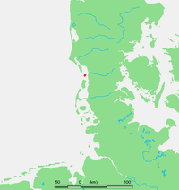
Mandø
Encyclopedia
Danish Wadden Sea Islands
The Danish Wadden Sea Islands are a group of islands on the western coast of Jutland, Denmark. They belong to the new region of Southern Denmark since January 1, 2007...
off the southwest coast
Coast
A coastline or seashore is the area where land meets the sea or ocean. A precise line that can be called a coastline cannot be determined due to the dynamic nature of tides. The term "coastal zone" can be used instead, which is a spatial zone where interaction of the sea and land processes occurs...
of Jutland
Jutland
Jutland , historically also called Cimbria, is the name of the peninsula that juts out in Northern Europe toward the rest of Scandinavia, forming the mainland part of Denmark. It has the North Sea to its west, Kattegat and Skagerrak to its north, the Baltic Sea to its east, and the Danish–German...
, Denmark
Denmark
Denmark is a Scandinavian country in Northern Europe. The countries of Denmark and Greenland, as well as the Faroe Islands, constitute the Kingdom of Denmark . It is the southernmost of the Nordic countries, southwest of Sweden and south of Norway, and bordered to the south by Germany. Denmark...
in the Wadden Sea
Wadden Sea
The Wadden Sea is an intertidal zone in the southeastern part of the North Sea. It lies between the coast of northwestern continental Europe and the range of Frisian Islands, forming a shallow body of water with tidal flats and wetlands. It is rich in biological diversity...
, part of the North Sea
North Sea
In the southwest, beyond the Straits of Dover, the North Sea becomes the English Channel connecting to the Atlantic Ocean. In the east, it connects to the Baltic Sea via the Skagerrak and Kattegat, narrow straits that separate Denmark from Norway and Sweden respectively...
. The island covers an area of 7.63 km² and has 62 inhabitants. The island is situated approximately 12 kilometers southwest of the ancient town of Ribe
Ribe
Ribe , the oldest extant Danish town, is in southwest Jutland and has a population of 8,192 . Until 1 January 2007, it was the seat of both the surrounding municipality, and county...
.
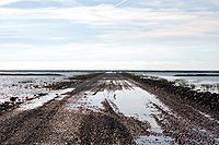
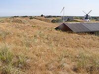
Mandø is barely accessible at high tide over an unpaved surface level causeway
Causeway
In modern usage, a causeway is a road or railway elevated, usually across a broad body of water or wetland.- Etymology :When first used, the word appeared in a form such as “causey way” making clear its derivation from the earlier form “causey”. This word seems to have come from the same source by...
of about four kilometers in length that connects the island to the mainland
Mainland
Mainland is a name given to a large landmass in a region , or to the largest of a group of islands in an archipelago. Sometimes its residents are called "Mainlanders"...
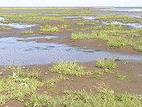
. Extensive mudflat
Mudflat
Mudflats or mud flats, also known as tidal flats, are coastal wetlands that form when mud is deposited by tides or rivers. They are found in sheltered areas such as bays, bayous, lagoons, and estuaries. Mudflats may be viewed geologically as exposed layers of bay mud, resulting from deposition of...
s and tidal marsh
Marsh
In geography, a marsh, or morass, is a type of wetland that is subject to frequent or continuous flood. Typically the water is shallow and features grasses, rushes, reeds, typhas, sedges, other herbaceous plants, and moss....
es encircle the island and provide breeding areas to multitudes of bird
Bird
Birds are feathered, winged, bipedal, endothermic , egg-laying, vertebrate animals. Around 10,000 living species and 188 families makes them the most speciose class of tetrapod vertebrates. They inhabit ecosystems across the globe, from the Arctic to the Antarctic. Extant birds range in size from...
s and other organism
Organism
In biology, an organism is any contiguous living system . In at least some form, all organisms are capable of response to stimuli, reproduction, growth and development, and maintenance of homoeostasis as a stable whole.An organism may either be unicellular or, as in the case of humans, comprise...
s. In the past centuries a large earthen dike has been constructed around the perimeter
Perimeter
A perimeter is a path that surrounds an area. The word comes from the Greek peri and meter . The term may be used either for the path or its length - it can be thought of as the length of the outline of a shape. The perimeter of a circular area is called circumference.- Practical uses :Calculating...
of the island, although substantially set back from the shore
Shore
A shore or shoreline is the fringe of land at the edge of a large body of water, such as an ocean, sea, or lake. In Physical Oceanography a shore is the wider fringe that is geologically modified by the action of the body of water past and present, while the beach is at the edge of the shore,...
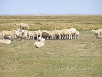
line. This artifice has allowed conventional farming in the form of grain
GRAIN
GRAIN is a small international non-profit organisation that works to support small farmers and social movements in their struggles for community-controlled and biodiversity-based food systems. Our support takes the form of independent research and analysis, networking at local, regional and...
growing and sheep grazing
Grazing
Grazing generally describes a type of feeding, in which a herbivore feeds on plants , and also on other multicellular autotrophs...
. Mandø is technically a hallig
Hallig
The Halligen are ten small German islands without protective dikes in the North Frisian Islands on Schleswig-Holstein's Wadden Sea-North Sea coast in the district of Nordfriesland....
, although it is far from the ten German
Germany
Germany , officially the Federal Republic of Germany , is a federal parliamentary republic in Europe. The country consists of 16 states while the capital and largest city is Berlin. Germany covers an area of 357,021 km2 and has a largely temperate seasonal climate...
islands commonly described by that term. The name was formerly often spelled Manø.
Logistics of access
Causeway
In modern usage, a causeway is a road or railway elevated, usually across a broad body of water or wetland.- Etymology :When first used, the word appeared in a form such as “causey way” making clear its derivation from the earlier form “causey”. This word seems to have come from the same source by...
unpaved roadway, although this route is compromised in storm
Storm
A storm is any disturbed state of an astronomical body's atmosphere, especially affecting its surface, and strongly implying severe weather...
s at high tide. The nearest village on the mainland which is the gateway to Mandø Island is Vester Vedsted. This simple causeway road is no more than copious gravel laid down on an immense mudflat, with required frequent periodic maintenance of added gravels. Alternatively many visitors reach the island by way of a specially designed tractor
Tractor
A tractor is a vehicle specifically designed to deliver a high tractive effort at slow speeds, for the purposes of hauling a trailer or machinery used in agriculture or construction...
pulled bus with greatly oversized tires. This vehicle is capable of traversing some of the firmer mudflats, but only at the lowest tides. In any case private vehicles or the "Mandø bus" leave the mainland at the point of the Wadden Sea Centre, which offers nature information and boasts a small museum
Museum
A museum is an institution that cares for a collection of artifacts and other objects of scientific, artistic, cultural, or historical importance and makes them available for public viewing through exhibits that may be permanent or temporary. Most large museums are located in major cities...
devoted to the natural history of Mandø. Mandø is located midway between the two larger islands Fanø
Fanø
Fanø is a Danish island in the North Sea off the coast of southwestern Denmark, and is the very northernmost of the Danish Wadden Sea Islands...
and Rømø
Rømø
Rømø is a Danish island in the Wadden Sea. Rømø is part of Tønder municipality. The island has 650 inhabitants as of 1 January 2011 and covers an area of 129 km². Rømø is a popular tourist spot each year....
which are connected to the mainland by a ferry and a road running across a causeway, respectively.
Geology and regional setting
North Frisian Islands
The North Frisian Islands are a group of islands in the Wadden Sea, a part of the North Sea, off the western coast of Schleswig-Holstein, Germany. The German islands are in the traditional region of North Frisia and are part of the Schleswig-Holstein Wadden Sea National Park and the Kreis of...
off the southwestern Danish and northwestern German coast. The Frisian Islands are generally the line of demarcation separating the North Sea
North Sea
In the southwest, beyond the Straits of Dover, the North Sea becomes the English Channel connecting to the Atlantic Ocean. In the east, it connects to the Baltic Sea via the Skagerrak and Kattegat, narrow straits that separate Denmark from Norway and Sweden respectively...
from the Wadden Sea
Wadden Sea
The Wadden Sea is an intertidal zone in the southeastern part of the North Sea. It lies between the coast of northwestern continental Europe and the range of Frisian Islands, forming a shallow body of water with tidal flats and wetlands. It is rich in biological diversity...
, which is a shallow sea of approximately 5000 square kilometers in size, riddled with small islands and tidal flats. The entire Wadden Sea area was formed by intervening river
River
A river is a natural watercourse, usually freshwater, flowing towards an ocean, a lake, a sea, or another river. In a few cases, a river simply flows into the ground or dries up completely before reaching another body of water. Small rivers may also be called by several other names, including...
ine depositional periods between Ice Age
Ice age
An ice age or, more precisely, glacial age, is a generic geological period of long-term reduction in the temperature of the Earth's surface and atmosphere, resulting in the presence or expansion of continental ice sheets, polar ice sheets and alpine glaciers...
glacier
Glacier
A glacier is a large persistent body of ice that forms where the accumulation of snow exceeds its ablation over many years, often centuries. At least 0.1 km² in area and 50 m thick, but often much larger, a glacier slowly deforms and flows due to stresses induced by its weight...
movements.
Ecology
Ecosystem
An ecosystem is a biological environment consisting of all the organisms living in a particular area, as well as all the nonliving , physical components of the environment with which the organisms interact, such as air, soil, water and sunlight....
s on this island are: tidal marsh
Marsh
In geography, a marsh, or morass, is a type of wetland that is subject to frequent or continuous flood. Typically the water is shallow and features grasses, rushes, reeds, typhas, sedges, other herbaceous plants, and moss....
; mudflat
Mudflat
Mudflats or mud flats, also known as tidal flats, are coastal wetlands that form when mud is deposited by tides or rivers. They are found in sheltered areas such as bays, bayous, lagoons, and estuaries. Mudflats may be viewed geologically as exposed layers of bay mud, resulting from deposition of...
; littoral
Littoral
The littoral zone is that part of a sea, lake or river that is close to the shore. In coastal environments the littoral zone extends from the high water mark, which is rarely inundated, to shoreline areas that are permanently submerged. It always includes this intertidal zone and is often used to...
zone; and upland grassland
Grassland
Grasslands are areas where the vegetation is dominated by grasses and other herbaceous plants . However, sedge and rush families can also be found. Grasslands occur naturally on all continents except Antarctica...
or coastal prairie
Coastal prairie
Coastal prairie may refer to either:* The California coastal prairie, a plant community found along the coasts of California and Oregon* The Western Gulf coastal grasslands of Louisiana, Texas, and Tamaulipas...
. In fact, there is about as much land area in mudflat as the considerable arable land of the island. Mandø Island is known for its extensive birdlife. Breeding birds consist of tern
Tern
Terns are seabirds in the family Sternidae, previously considered a subfamily of the gull family Laridae . They form a lineage with the gulls and skimmers which in turn is related to skuas and auks...
s, sandpipers, many wader
Wader
Waders, called shorebirds in North America , are members of the order Charadriiformes, excluding the more marine web-footed seabird groups. The latter are the skuas , gulls , terns , skimmers , and auks...
s and duck
Duck
Duck is the common name for a large number of species in the Anatidae family of birds, which also includes swans and geese. The ducks are divided among several subfamilies in the Anatidae family; they do not represent a monophyletic group but a form taxon, since swans and geese are not considered...
s including eider
Eider
Eiders are large seaducks in the genus Somateria. Steller's Eider, despite its name, is in a different genus.The three extant species all breed in the cooler latitudes of the Northern hemisphere....
s. Mudflats and marshes afford birds a safe and undisturbed location for feeding, resting and breeding.
There are also a variety of insects, marine organisms and small mammals that find habitat on this island. Many grasses and wildflower
Wildflower
A wildflower is a flower that grows wild, meaning it was not intentionally seeded or planted. Yet "wildflower" meadows of a few mixed species are sold in seed packets. The term "wildflower" has been made vague by commercial seedsmen who are interested in selling more flowers or seeds more...
s populate the upland portion of the island, in addition to marsh grasses in the intertidal zone. Besides the indigenous wildlife
Wildlife
Wildlife includes all non-domesticated plants, animals and other organisms. Domesticating wild plant and animal species for human benefit has occurred many times all over the planet, and has a major impact on the environment, both positive and negative....
there are sheep which are grazed on the island and along part of the causeway.
History
The first written record of Mandø dates from 1231. The meaning of the original name Mannæø or Mannø is disputed. According to one interpretation the name means the Isle of Men. It has also been interpreted as relating to a burial site for victims of shipwrecks. A number of islands in SwedenSweden
Sweden , officially the Kingdom of Sweden , is a Nordic country on the Scandinavian Peninsula in Northern Europe. Sweden borders with Norway and Finland and is connected to Denmark by a bridge-tunnel across the Öresund....
have similar names with this meaning. A third interpretation explains it as derived from the name Manni.
A local record, Avia Ripensis , mentions the existence of a local church in 1340. The current building dates from 1727. The island belonged to the royal demesne
Demesne
In the feudal system the demesne was all the land, not necessarily all contiguous to the manor house, which was retained by a lord of the manor for his own use and support, under his own management, as distinguished from land sub-enfeoffed by him to others as sub-tenants...
until 1741 when the islanders purchased it on an auction. Mandø remains sparsely populated compared to the neighbouring islands, Fanø
Fanø
Fanø is a Danish island in the North Sea off the coast of southwestern Denmark, and is the very northernmost of the Danish Wadden Sea Islands...
and Rømø
Rømø
Rømø is a Danish island in the Wadden Sea. Rømø is part of Tønder municipality. The island has 650 inhabitants as of 1 January 2011 and covers an area of 129 km². Rømø is a popular tourist spot each year....
. The census
Census
A census is the procedure of systematically acquiring and recording information about the members of a given population. It is a regularly occurring and official count of a particular population. The term is used mostly in connection with national population and housing censuses; other common...
of 1890 records the island's population as 262, a number which has now dwindled to c. 70.
The island has been hit by storm floods on several occasions. A dyke known as Bydiget ('village dyke') was constructed in 1887 east of the main settlement. A second one, Havnediget ('harbour dyke'), was constructed in 1937 protecting the northern part of the island, Gammel Mandø ('Old Mandø'). Both dykes breached in a flood in 1981.
Life on the island was first supported by a combination of agriculture and fishery. Fishing was the responsibility of the island's men and agriculture was managed by the women. The island was later associated with seafaring. In the 20th century, agriculture became a dominant trade. At its peak, the number of farms was 25, a number dwindling to a single one by 1997.
Notable Native
Eugenius WarmingEugenius Warming
Johannes Eugenius Bülow Warming , known as Eugen Warming, was a Danish botanist and a main founding figure of the scientific discipline of ecology...
(1841-1924), recognized as the founding figure of the scientific discipline of Ecology, was born and lived until about the age of three on the island.