
Main Yarra Trail
Encyclopedia
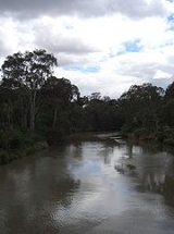
The Yarra Trail is a shared use path for cyclists
and pedestrian
s, which follows the Yarra River
through the north eastern suburbs of Melbourne
, Victoria
, Australia
.
The trail follows the river from near its mouth, through the city and suburbs to Westerfolds Park and Eltham
. The Capital City Trail
uses the same path up to Dights Falls
, where it continues up the Merri Creek Trail
as part of its loop around the city.
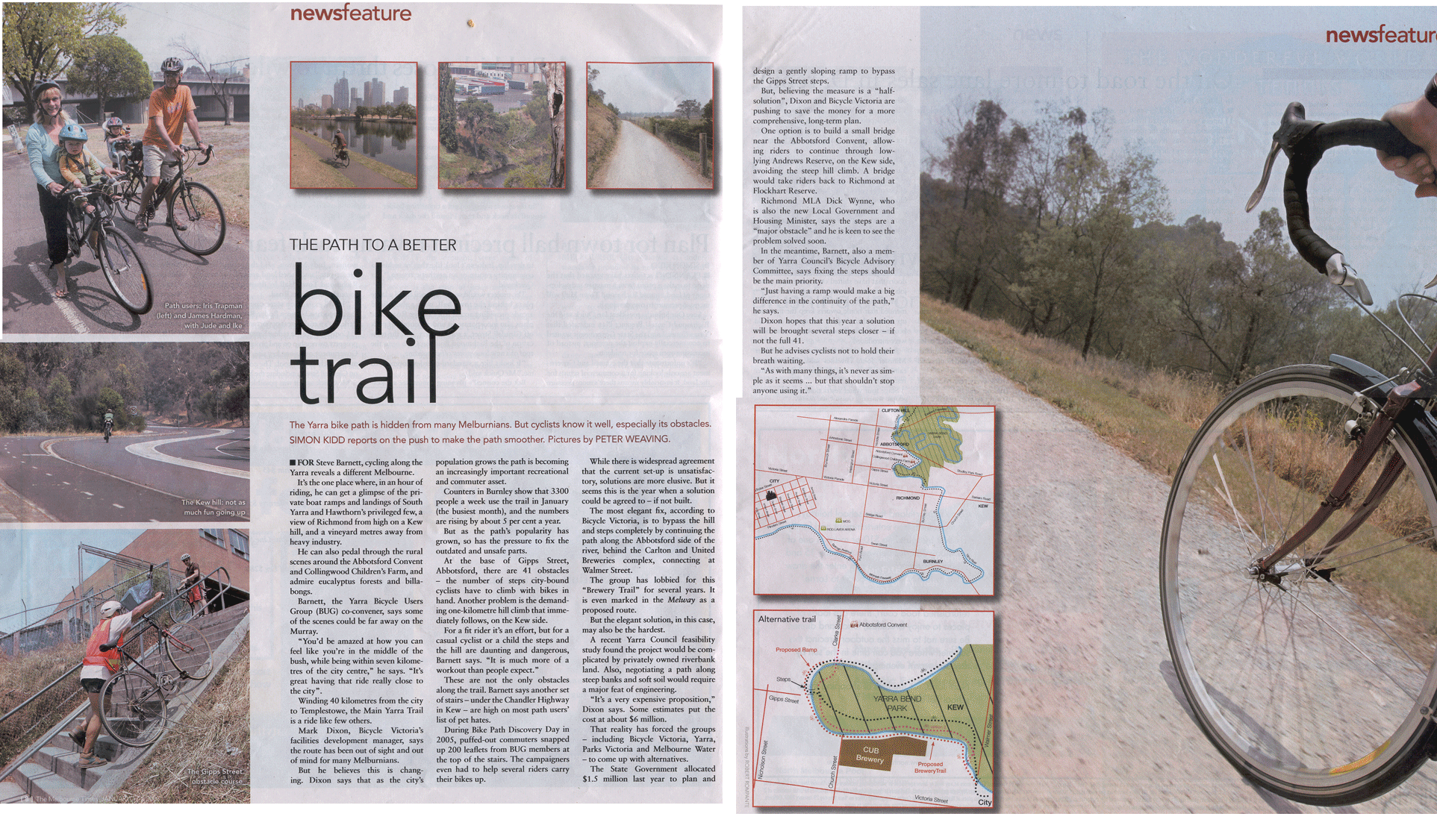
Bicycle Victoria
has an ongoing campaign to have the path in Yarra Bend Park improved and the stairs at the east end of Gipps Street
effectively removed from the trail by continuing the path on the west side of the river. Other alternatives include installing a ramp or installing a new footbridge near the Abbotsford Convent.
near the mouth of the Yarra River as it enters Port Phillip Bay by the punt landing. The punt allows cyclists and pedestrians to cross to Spotswood
and the Hobsons Bay Coastal Trail
and the Scienceworks Museum
.
From the punt landing, the trail winds through Melbourne Docklands
, initially as dedicated path on Lorimer St and then east of Todd Rd, continues as an on-road cycling lane on Lorimer St.
At the west side of Yarra's Edge and before the Docklands Highway
, head off the road towards the bank of the river. The trail can be picked up, where it intersects with the Capital City Trail
, at the southern end of the "Koori
Eel Trap" footbridge.
The trail passes the north side of Jeff's Shed
, the Crown Casino
and the restaurant sector of Southbank
on the shared and often busy pedestrian boulevarde with excellent views of the Melbourne CBD across the Yarra River.
At the pedestrian bridge at Southbank you can choose to continue on the south bank or cross and follow the river on the north bank. The trail goes under the Princes Bridge next to Flinders Street Station
, which is the starting point for the St Kilda road cycling lane to St Kilda
beach; and Swanston street
, a major cycling route through the city to Royal Melbourne Institute of Technology
city campus, Melbourne University and the inner northern suburbs.
On the north side of the river you can visit Federation Square
, the newly established riverside park of Birrarung Marr, Melbourne Park
, Melbourne Cricket Ground
. On the south bank of the Yarra river you pass several rowing clubs with their boatsheds. You may come across a rowing coach cycling one handed while yelling instructions through a megaphone to the rowing team on the river. You will pass the Melbourne Botanic Gardens
and historic Como House nearby. At MacRobertson Bridge
the paths meet on the north side of the river.
In Richmond
the path meets up with the Gardiners Creek Trail
. After going under the Victoria street bridge in Abbotsford
the path reaches the Walmer St shared pedestrian and cycle bridge.
Once across the bridge on the north side of the river, travel halfway up the short steep hill (Walmer St) and turn immediately to the left (west) into the park. Travel along the path until it reaches Yarra boulevarde, where the path descends to cross the Yarra River again at the Gipps Street shared pedestrian and cycle bridge. Alternatively continue to follow the Yarra boulevarde to Studley Park - see below.
At Gipps Street
, flights of steps connect to the concrete path on the western side of the river. Some cyclists choose to avoid the steps and ride the back streets of Abbotsford
to meet the trail at the Collingwood Children's Farm
.
A short way further the trail comes to Dights Falls
, an ancient meeting place for the Wurundjeri
people and tribes of the Kulin
nation. The weir and water race where used to power the Ceres flour mill once located here. Here the Capital City Trail
follows the Merri Creek Trail
up the Merri Creek
. The Yarra River Trail crosses the Merri Creek here, passes under the Eastern Freeway and starts a long gradual up hill climb to Fairfield Hospital, before crossing the Yarra river at the pedestrian Pipe bridge at the Fairfield
boathouse. The bridge is fairly narrow and you will need to walk across when it is busy. On the eastern side of the river the path climbs up steeply to Yarra boulevarde. Stop at the top to admire the sweeping views of the city skyline across Yarra Bend Park.
An interesting alternative to the Yarra River Trail at Yarra Bend Park is to follow the Yarra boulevarde as it meanders through the parkland of Yarra Bend following the river. It is a tourist drive with on-road cycling lanes, which provides access to the Studley Park boathouse, where row boats can be hired. After crossing the Eastern Freeway the road climbs up a hill where it meets the Yarra Trail again.
From the top of the hill follow the Yarra boulevard down to the Chandler Highway
. You can choose to wheel your bike down some steps to go under the bridge, or use the pedestrian crossing to access a ramped connecting path that leads down to the Yarra path, next to the National Guide Dog and Mobility Centre.
The northern end of the Anniversary Outer Circle Trail
is 0.6 km from this point. Head south on the Chandler Highway
and the Anniversary Trail
can be found just across the bridge that crosses the Eastern Freeway. A safer alternative is to continue along the Yarra River Trail from the Chandler Highway
to Willsmere Park - 1.5 km. You can cross under the Eastern Freeway at Willsmere Park and traverse to the Anniversary Trail
via Hyde Park.
The Yarra River Trail soon follows the Eastern Freeway beside a golf course before again rejoining the Yarra river near Burke Rd. Here you find the turn off to the Koonung Creek Trail
. Using a highly convoluted and hilly path, with some road sections, one can access the Darebin Creek Trail
via the Darebin station from this point.
Along river flats, beside sporting ovals, market gardens, and paddocks with horses: it is easy to forget this parkland is in the middle of Melbourne's suburbs as you ride through Ivanhoe
, Heidelberg
, Lower Plenty
and Templestowe
to Westerfolds Park where there are many paths to explore.
On the way to Westerfolds Park you will find the turnoffs to the River Gum Walk Trail
, the Plenty River Trail
and the Ruffey Creek Trail
.
The southerly section of the River Gum Walk Trail
can easily be mistaken for the continuation of the Yarra River Trail. People coming from the south along the Yarra River Trail should turn right (east) 130m after crossing the canal at the end of Plymouth St, near the Banyule Tennis centre.
From the north east corner of Westerfolds Park, the path continues up the Yarra River 1 km to Candlebark Park. Cross the long footbridge across the Yarra at Candlebark Park to access the Diamond Creek Trail
. The intersection is unsigned except for some instructions relating to the usage of the park.
The Yarra trail continues to follow the river past Pettys orchards and finally ends at the confluence
of the Mullum Mullum Creek and the Yarra River in Templestowe
. A lookout surveys the spot. The Mullum Mullum Creek Trail
starts here leading to points further afield.
, Docklands
, Southbank
, Yarra Bend Park, Collingwood Children's Farm
, Westerfolds Park.
Capital City Trail
, Anniversary Trail
, Koonung Creek Trail
, River Gum Walk Trail
, Plenty River Trail
, Ruffey Creek Trail
, Diamond Creek Trail
and lower Mullum Mullum Creek Trail
.
West end at 37.829302°S 144.900715°E.
East end at 37.738386°S 145.161994°E.
Cycling
Cycling, also called bicycling or biking, is the use of bicycles for transport, recreation, or for sport. Persons engaged in cycling are cyclists or bicyclists...
and pedestrian
Pedestrian
A pedestrian is a person traveling on foot, whether walking or running. In some communities, those traveling using roller skates or skateboards are also considered to be pedestrians. In modern times, the term mostly refers to someone walking on a road or footpath, but this was not the case...
s, which follows the Yarra River
Yarra River
The Yarra River, originally Birrarung, is a river in east-central Victoria, Australia. The lower stretches of the river is where the city of Melbourne was established in 1835 and today Greater Melbourne dominates and influences the landscape of its lower reaches...
through the north eastern suburbs of Melbourne
Melbourne
Melbourne is the capital and most populous city in the state of Victoria, and the second most populous city in Australia. The Melbourne City Centre is the hub of the greater metropolitan area and the Census statistical division—of which "Melbourne" is the common name. As of June 2009, the greater...
, Victoria
Victoria (Australia)
Victoria is the second most populous state in Australia. Geographically the smallest mainland state, Victoria is bordered by New South Wales, South Australia, and Tasmania on Boundary Islet to the north, west and south respectively....
, Australia
Australia
Australia , officially the Commonwealth of Australia, is a country in the Southern Hemisphere comprising the mainland of the Australian continent, the island of Tasmania, and numerous smaller islands in the Indian and Pacific Oceans. It is the world's sixth-largest country by total area...
.
The trail follows the river from near its mouth, through the city and suburbs to Westerfolds Park and Eltham
Eltham, Victoria
Eltham is a suburb in Melbourne, Victoria, Australia, 20 km north-east from Melbourne's central business district. Its Local Government Area is the Shire of Nillumbik. At the 2006 Census, Eltham had a population of 17,581....
. The Capital City Trail
Capital City Trail
The Capital City Trail is a shared use path for cyclists and pedestrians, which circles the Melbourne city centre and some inner eastern and northern suburbs of Melbourne, Victoria, Australia....
uses the same path up to Dights Falls
Dights Falls
Dights Falls is located in Melbourne, Victoria just downstream of the junction of the Yarra River with Merri Creek. At this point the river narrows and is constricted between 800,000 year old volcanic, basaltic lava flow and a much older steep, silurian, sedimentary spur...
, where it continues up the Merri Creek Trail
Merri Creek Trail
The Merri Creek Trail is a shared use path for cyclists and pedestrians, which follows the Merri Creek through the northern suburbs of Melbourne, Victoria, Australia.-Following the Path:...
as part of its loop around the city.
Bicycle Victoria
Bicycle Victoria
Bicycle Network Victoria is a community-based not-for-profit organisation, one of the largest cycling membership organisations in the world , whose mission is to get More People Cycling More Often. The name was changed from Bicycle Victoria to Bicycle Network Victoria in July 2011...
has an ongoing campaign to have the path in Yarra Bend Park improved and the stairs at the east end of Gipps Street
George Gipps
Sir George Gipps was Governor of the colony of New South Wales, Australia, for eight years, between 1838 and 1846. His governorship was during a period of great change for New South Wales and Australia, as well as for New Zealand, which was administered as part of New South Wales for much of this...
effectively removed from the trail by continuing the path on the west side of the river. Other alternatives include installing a ramp or installing a new footbridge near the Abbotsford Convent.
Following the Path
The path starts just to the north of West Gate BridgeWest Gate Bridge
The West Gate Bridge is a steel box girder cable-stayed bridge in Melbourne, Victoria, Australia. It spans the Yarra River, just north of its mouth into Port Phillip, and is a vital link between the inner city and Melbourne's western suburbs with the industrial suburbs in the west and with the city...
near the mouth of the Yarra River as it enters Port Phillip Bay by the punt landing. The punt allows cyclists and pedestrians to cross to Spotswood
Spotswood, Victoria
Spotswood is a suburb in Melbourne, Victoria, Australia, 7 km south-west from Melbourne's central business district. Its Local Government Area is the City of Hobsons Bay...
and the Hobsons Bay Coastal Trail
Hobsons Bay Coastal Trail
The Hobsons Bay Coastal Trail is a shared use path for cyclists and pedestrians, which follows the coast line of Hobsons Bay in the inner western suburbs in Melbourne, Victoria, Australia. The trail forms part of the western half of the Bayside Trail which encircles Port Phillip...
and the Scienceworks Museum
Scienceworks Museum (Melbourne)
Scienceworks is a world renowned science museum in Melbourne, Australia. It is a venue of Museum Victoria which administers the cultural and scientific collections of the State of Victoria...
.
From the punt landing, the trail winds through Melbourne Docklands
Melbourne Docklands
Docklands is an inner city suburb in Melbourne, Victoria, Australia occupying an area extending up to 2 km west of and adjacent to Melbourne's Central Business District . Its Local Government Area is the City of Melbourne...
, initially as dedicated path on Lorimer St and then east of Todd Rd, continues as an on-road cycling lane on Lorimer St.
At the west side of Yarra's Edge and before the Docklands Highway
Docklands Highway
Docklands Highway is a highway with a mix of many arterial roads in inner western Melbourne, Australia.- Otherwise Known As :There are a variety of street names which exceed the Docklands Highway status which includes:...
, head off the road towards the bank of the river. The trail can be picked up, where it intersects with the Capital City Trail
Capital City Trail
The Capital City Trail is a shared use path for cyclists and pedestrians, which circles the Melbourne city centre and some inner eastern and northern suburbs of Melbourne, Victoria, Australia....
, at the southern end of the "Koori
Koori
The Koori are the indigenous Australians that traditionally occupied modern day New South Wales and Victoria....
Eel Trap" footbridge.
The trail passes the north side of Jeff's Shed
Melbourne Exhibition and Convention Centre
The Melbourne Convention and Exhibition Centre is the name given to two adjacent buildings next to the Yarra River in South Wharf, an inner-city suburb of Melbourne, Victoria, Australia...
, the Crown Casino
Crown Casino
Crown Casino and Entertainment Complex is a large casino and entertainment precinct located on the south bank of the Yarra River, in Melbourne, Australia. Crown Casino is a unit of Crown Limited....
and the restaurant sector of Southbank
Southbank, Victoria
Southbank is an inner city suburb of Melbourne, Victoria, Australia located direct south of the Yarra River opposite Melbourne's Hoddle Grid. The northernmost area is considered part of the Central Business District and Central Activities District of the city. Its Local Government Area are the...
on the shared and often busy pedestrian boulevarde with excellent views of the Melbourne CBD across the Yarra River.
At the pedestrian bridge at Southbank you can choose to continue on the south bank or cross and follow the river on the north bank. The trail goes under the Princes Bridge next to Flinders Street Station
Flinders Street Station
Flinders Street Station is the central railway station of the suburban railway network of Melbourne, Victoria, Australia. It is on the corner of Flinders and Swanston Streets next to the Yarra River in the heart of the city, stretching from Swanston Street to Queen Street and covering two city...
, which is the starting point for the St Kilda road cycling lane to St Kilda
St Kilda, Victoria
St Kilda is an inner city suburb of Melbourne, Victoria, Australia, 6 km south from Melbourne's central business district. Its Local Government Area is the City of Port Phillip...
beach; and Swanston street
Swanston Street, Melbourne
Swanston Street is a major thoroughfare in the centre of Melbourne, Australia. It is historically one of the main streets of central Melbourne, laid out in 1837 as part of the Hoddle Grid, the layout of major streets that makes up the central business district...
, a major cycling route through the city to Royal Melbourne Institute of Technology
RMIT University
RMIT University is an Australian public university located in Melbourne, Victoria. It has two branches, referred to as RMIT University in Australia and RMIT International University in Vietnam....
city campus, Melbourne University and the inner northern suburbs.
On the north side of the river you can visit Federation Square
Federation Square
Federation Square is a civic centre and cultural precinct in the city of Melbourne, Victoria, Australia....
, the newly established riverside park of Birrarung Marr, Melbourne Park
Melbourne Park
Melbourne Park is a sports venue in the Melbourne Sports and Entertainment Precinct in Melbourne, Victoria, Australia. Since 1988, Melbourne Park has been home of the Australian Open in tennis, which is played annually in January...
, Melbourne Cricket Ground
Melbourne Cricket Ground
The Melbourne Cricket Ground is an Australian sports stadium located in Yarra Park, Melbourne and is home to the Melbourne Cricket Club. It is the tenth largest stadium in the world, the largest in Australia, the largest stadium for playing cricket, and holds the world record for the highest light...
. On the south bank of the Yarra river you pass several rowing clubs with their boatsheds. You may come across a rowing coach cycling one handed while yelling instructions through a megaphone to the rowing team on the river. You will pass the Melbourne Botanic Gardens
Royal Botanic Gardens, Melbourne
The Royal Botanic Gardens Melbourne are internationally renowned botanical gardens located near the centre of Melbourne, Victoria, Australia, on the south bank of the Yarra River. They are 38 hectares of landscaped gardens consisting of a mix of native and non-native vegetation including over...
and historic Como House nearby. At MacRobertson Bridge
MacRobertson Bridge
The MacRobertson Bridge is a road bridge that carries Grange Road from Toorak on the south bank into Burnley, over the Yarra River and the Monash Freeway in Melbourne, Victoria, Australia....
the paths meet on the north side of the river.
In Richmond
Richmond, Victoria
Richmond is a suburb in Melbourne, Victoria, Australia, 3 km south-east from Melbourne's central business district. Its Local Government Area is the City of Yarra...
the path meets up with the Gardiners Creek Trail
Gardiners Creek Trail
The Gardiners Creek Trail is a shared use path for cyclists and pedestrians, which follows Gardiners Creek through the eastern suburbs of Melbourne, Victoria, Australia....
. After going under the Victoria street bridge in Abbotsford
Abbotsford, Victoria
Abbotsford is a suburb in Melbourne, Victoria, Australia, 2 km east from Melbourne's central business district. Its Local Government Area is the City of Yarra. At the 2006 Census, Abbotsford had a population of 4,327....
the path reaches the Walmer St shared pedestrian and cycle bridge.
Once across the bridge on the north side of the river, travel halfway up the short steep hill (Walmer St) and turn immediately to the left (west) into the park. Travel along the path until it reaches Yarra boulevarde, where the path descends to cross the Yarra River again at the Gipps Street shared pedestrian and cycle bridge. Alternatively continue to follow the Yarra boulevarde to Studley Park - see below.
At Gipps Street
George Gipps
Sir George Gipps was Governor of the colony of New South Wales, Australia, for eight years, between 1838 and 1846. His governorship was during a period of great change for New South Wales and Australia, as well as for New Zealand, which was administered as part of New South Wales for much of this...
, flights of steps connect to the concrete path on the western side of the river. Some cyclists choose to avoid the steps and ride the back streets of Abbotsford
Abbotsford, Victoria
Abbotsford is a suburb in Melbourne, Victoria, Australia, 2 km east from Melbourne's central business district. Its Local Government Area is the City of Yarra. At the 2006 Census, Abbotsford had a population of 4,327....
to meet the trail at the Collingwood Children's Farm
Collingwood Children's Farm
The Collingwood Children’s Farm is a not-for-profit, inner city farm situated on the Yarra River in the Melbourne suburb of Abbotsford, Australia. It is adjacent to, and considered part of the larger Abbotsford Convent complex. The Abbotsford Heritage Precinct Farmlands supporting the Farm are...
.
A short way further the trail comes to Dights Falls
Dights Falls
Dights Falls is located in Melbourne, Victoria just downstream of the junction of the Yarra River with Merri Creek. At this point the river narrows and is constricted between 800,000 year old volcanic, basaltic lava flow and a much older steep, silurian, sedimentary spur...
, an ancient meeting place for the Wurundjeri
Wurundjeri
The Wurundjeri are a people of the Indigenous Australian nation of the Woiwurrung language group, in the Kulin alliance, who occupy the Birrarung Valley, its tributaries and the present location of Melbourne, Australia...
people and tribes of the Kulin
Kulin
The Kulin nation, was an alliance of five Indigenous Australian nations in Central Victoria, Australia, prior to European settlement. Their collective territory extended to around Port Phillip and Western Port, up into the Great Dividing Range and the Loddon and Goulburn River valleys. To their...
nation. The weir and water race where used to power the Ceres flour mill once located here. Here the Capital City Trail
Capital City Trail
The Capital City Trail is a shared use path for cyclists and pedestrians, which circles the Melbourne city centre and some inner eastern and northern suburbs of Melbourne, Victoria, Australia....
follows the Merri Creek Trail
Merri Creek Trail
The Merri Creek Trail is a shared use path for cyclists and pedestrians, which follows the Merri Creek through the northern suburbs of Melbourne, Victoria, Australia.-Following the Path:...
up the Merri Creek
Merri Creek
The Merri Creek is a waterway in southern parts of Victoria, Australia which flows through the northern suburbs of Melbourne. It begins in Wallan north of Melbourne and flows south for 70km until it joins the Yarra River at Dights Falls...
. The Yarra River Trail crosses the Merri Creek here, passes under the Eastern Freeway and starts a long gradual up hill climb to Fairfield Hospital, before crossing the Yarra river at the pedestrian Pipe bridge at the Fairfield
Fairfield, Victoria
Fairfield is a suburb in Melbourne, Victoria, Australia, 6 km north-east from Melbourne's central business district. Its Local Government Area are the Cities of Darebin and Yarra...
boathouse. The bridge is fairly narrow and you will need to walk across when it is busy. On the eastern side of the river the path climbs up steeply to Yarra boulevarde. Stop at the top to admire the sweeping views of the city skyline across Yarra Bend Park.
An interesting alternative to the Yarra River Trail at Yarra Bend Park is to follow the Yarra boulevarde as it meanders through the parkland of Yarra Bend following the river. It is a tourist drive with on-road cycling lanes, which provides access to the Studley Park boathouse, where row boats can be hired. After crossing the Eastern Freeway the road climbs up a hill where it meets the Yarra Trail again.
From the top of the hill follow the Yarra boulevard down to the Chandler Highway
Chandler Highway
Chandler Highway is a short road in the inner eastern suburbs of Melbourne. It runs from Heidelberg Road in Alphington, across the Yarra River, using a narrow two-lane bridge over the Yarra River, then continues across the Eastern Freeway, then terminates at an intersection with Princess Street and...
. You can choose to wheel your bike down some steps to go under the bridge, or use the pedestrian crossing to access a ramped connecting path that leads down to the Yarra path, next to the National Guide Dog and Mobility Centre.
The northern end of the Anniversary Outer Circle Trail
Outer Circle Trail
The Outer Circle Trail, also known as the Anniversary Trail, Anniversary Outer Circle Trail, or even the Outer Circle Anniversary Trail, is a shared use path for cyclists and pedestrians, which partly follows the Alamein Line through the inner eastern suburbs of Melbourne, Victoria, Australia.The...
is 0.6 km from this point. Head south on the Chandler Highway
Chandler Highway
Chandler Highway is a short road in the inner eastern suburbs of Melbourne. It runs from Heidelberg Road in Alphington, across the Yarra River, using a narrow two-lane bridge over the Yarra River, then continues across the Eastern Freeway, then terminates at an intersection with Princess Street and...
and the Anniversary Trail
Outer Circle Trail
The Outer Circle Trail, also known as the Anniversary Trail, Anniversary Outer Circle Trail, or even the Outer Circle Anniversary Trail, is a shared use path for cyclists and pedestrians, which partly follows the Alamein Line through the inner eastern suburbs of Melbourne, Victoria, Australia.The...
can be found just across the bridge that crosses the Eastern Freeway. A safer alternative is to continue along the Yarra River Trail from the Chandler Highway
Chandler Highway
Chandler Highway is a short road in the inner eastern suburbs of Melbourne. It runs from Heidelberg Road in Alphington, across the Yarra River, using a narrow two-lane bridge over the Yarra River, then continues across the Eastern Freeway, then terminates at an intersection with Princess Street and...
to Willsmere Park - 1.5 km. You can cross under the Eastern Freeway at Willsmere Park and traverse to the Anniversary Trail
Outer Circle Trail
The Outer Circle Trail, also known as the Anniversary Trail, Anniversary Outer Circle Trail, or even the Outer Circle Anniversary Trail, is a shared use path for cyclists and pedestrians, which partly follows the Alamein Line through the inner eastern suburbs of Melbourne, Victoria, Australia.The...
via Hyde Park.
The Yarra River Trail soon follows the Eastern Freeway beside a golf course before again rejoining the Yarra river near Burke Rd. Here you find the turn off to the Koonung Creek Trail
Koonung Creek Trail
The Koonung Creek Trail is a shared use path for cyclists and pedestrians, which follows Koonung Creek in the eastern suburbs of Melbourne, Victoria, Australia...
. Using a highly convoluted and hilly path, with some road sections, one can access the Darebin Creek Trail
Darebin Creek Trail
The Darebin Creek Trail is a shared use path for cyclists and pedestrians which follows Darebin Creek in the inner and outer northern suburbs of Melbourne, Victoria, Australia....
via the Darebin station from this point.
Along river flats, beside sporting ovals, market gardens, and paddocks with horses: it is easy to forget this parkland is in the middle of Melbourne's suburbs as you ride through Ivanhoe
Ivanhoe, Victoria
Ivanhoe is a suburb in Melbourne, Victoria, Australia, 10 km north-east from Melbourne's central business district. Its Local Government Area is the City of Banyule. At the 2006 Census, Ivanhoe had a population of 10,600.-History:...
, Heidelberg
Heidelberg, Victoria
Heidelberg is a suburb in Melbourne, Victoria, Australia, 11 km north-east from Melbourne's central business district. Its Local Government Area is the City of Banyule....
, Lower Plenty
Lower Plenty, Victoria
Lower Plenty is a suburb in Melbourne, Victoria, Australia, 16 km north-east from Melbourne's central business district. Its Local Government Area is the City of Banyule...
and Templestowe
Templestowe, Victoria
"Templestowe" redirects here. For the Victorian Legislative Council Province, please see Templestowe Province.Templestowe is a suburb in Melbourne, Victoria, Australia, 17 km north-east from Melbourne's central business district. Its Local Government Area is the City of Manningham...
to Westerfolds Park where there are many paths to explore.
On the way to Westerfolds Park you will find the turnoffs to the River Gum Walk Trail
River Gum Walk Trail
The River Gum Walk Trail is a shared use path for cyclists and pedestrians in the suburb of Rosanna, an inner northern suburb of Melbourne, Victoria, Australia.-Following the path:...
, the Plenty River Trail
Plenty River Trail
The Plenty River Trail is a shared use path for cyclists and pedestrians, which follows the Plenty River through the suburbs of Greensborough and Lower Plenty in Melbourne, Victoria, Australia....
and the Ruffey Creek Trail
Ruffey Creek Trail
The Ruffey Creek Trail is a shared use path for cyclists and pedestrians, which follows Ruffey Creek in the inner eastern suburbs of Templestowe and Doncaster in Melbourne, Victoria, Australia.Platypus are known to live in the creek.-Following the Path:...
.
The southerly section of the River Gum Walk Trail
River Gum Walk Trail
The River Gum Walk Trail is a shared use path for cyclists and pedestrians in the suburb of Rosanna, an inner northern suburb of Melbourne, Victoria, Australia.-Following the path:...
can easily be mistaken for the continuation of the Yarra River Trail. People coming from the south along the Yarra River Trail should turn right (east) 130m after crossing the canal at the end of Plymouth St, near the Banyule Tennis centre.
From the north east corner of Westerfolds Park, the path continues up the Yarra River 1 km to Candlebark Park. Cross the long footbridge across the Yarra at Candlebark Park to access the Diamond Creek Trail
Diamond Creek Trail
The Diamond Creek Trail is a shared use path for cyclists and pedestrians, which follows Diamond Creek through the north eastern outer suburbs of Melbourne, Victoria, Australia....
. The intersection is unsigned except for some instructions relating to the usage of the park.
The Yarra trail continues to follow the river past Pettys orchards and finally ends at the confluence
Confluence
Confluence, in geography, describes the meeting of two or more bodies of water.Confluence may also refer to:* Confluence , a property of term rewriting systems...
of the Mullum Mullum Creek and the Yarra River in Templestowe
Templestowe, Victoria
"Templestowe" redirects here. For the Victorian Legislative Council Province, please see Templestowe Province.Templestowe is a suburb in Melbourne, Victoria, Australia, 17 km north-east from Melbourne's central business district. Its Local Government Area is the City of Manningham...
. A lookout surveys the spot. The Mullum Mullum Creek Trail
Mullum Mullum Creek Trail
The Mullum Mullum Creek Trail is a shared use path for cyclists and pedestrians, which follows Mullum Mullum Creek in the outer eastern suburbs in Melbourne, Victoria, Australia....
starts here leading to points further afield.
Landmarks
Yarra RiverYarra River
The Yarra River, originally Birrarung, is a river in east-central Victoria, Australia. The lower stretches of the river is where the city of Melbourne was established in 1835 and today Greater Melbourne dominates and influences the landscape of its lower reaches...
, Docklands
Melbourne Docklands
Docklands is an inner city suburb in Melbourne, Victoria, Australia occupying an area extending up to 2 km west of and adjacent to Melbourne's Central Business District . Its Local Government Area is the City of Melbourne...
, Southbank
Southbank, Victoria
Southbank is an inner city suburb of Melbourne, Victoria, Australia located direct south of the Yarra River opposite Melbourne's Hoddle Grid. The northernmost area is considered part of the Central Business District and Central Activities District of the city. Its Local Government Area are the...
, Yarra Bend Park, Collingwood Children's Farm
Collingwood Children's Farm
The Collingwood Children’s Farm is a not-for-profit, inner city farm situated on the Yarra River in the Melbourne suburb of Abbotsford, Australia. It is adjacent to, and considered part of the larger Abbotsford Convent complex. The Abbotsford Heritage Precinct Farmlands supporting the Farm are...
, Westerfolds Park.
Connections
The trail leads to numerous other trails. Going from west to east:Capital City Trail
Capital City Trail
The Capital City Trail is a shared use path for cyclists and pedestrians, which circles the Melbourne city centre and some inner eastern and northern suburbs of Melbourne, Victoria, Australia....
, Anniversary Trail
Outer Circle Trail
The Outer Circle Trail, also known as the Anniversary Trail, Anniversary Outer Circle Trail, or even the Outer Circle Anniversary Trail, is a shared use path for cyclists and pedestrians, which partly follows the Alamein Line through the inner eastern suburbs of Melbourne, Victoria, Australia.The...
, Koonung Creek Trail
Koonung Creek Trail
The Koonung Creek Trail is a shared use path for cyclists and pedestrians, which follows Koonung Creek in the eastern suburbs of Melbourne, Victoria, Australia...
, River Gum Walk Trail
River Gum Walk Trail
The River Gum Walk Trail is a shared use path for cyclists and pedestrians in the suburb of Rosanna, an inner northern suburb of Melbourne, Victoria, Australia.-Following the path:...
, Plenty River Trail
Plenty River Trail
The Plenty River Trail is a shared use path for cyclists and pedestrians, which follows the Plenty River through the suburbs of Greensborough and Lower Plenty in Melbourne, Victoria, Australia....
, Ruffey Creek Trail
Ruffey Creek Trail
The Ruffey Creek Trail is a shared use path for cyclists and pedestrians, which follows Ruffey Creek in the inner eastern suburbs of Templestowe and Doncaster in Melbourne, Victoria, Australia.Platypus are known to live in the creek.-Following the Path:...
, Diamond Creek Trail
Diamond Creek Trail
The Diamond Creek Trail is a shared use path for cyclists and pedestrians, which follows Diamond Creek through the north eastern outer suburbs of Melbourne, Victoria, Australia....
and lower Mullum Mullum Creek Trail
Mullum Mullum Creek Trail
The Mullum Mullum Creek Trail is a shared use path for cyclists and pedestrians, which follows Mullum Mullum Creek in the outer eastern suburbs in Melbourne, Victoria, Australia....
.
West end at 37.829302°S 144.900715°E.
East end at 37.738386°S 145.161994°E.