
.gif)
M-28 Business (Newberry, Michigan)
Encyclopedia
M-28 Business Route was a state trunkline highway
in the Upper Peninsula
of Michigan
. It served as a business route
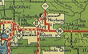
running for 9.01 miles (14.5 km) through the Newberry
area. The business loop followed a U-shaped routing to connect downtown Newberry with M-28
south of town. It ran west of the city of Newberry, passing through the community of Dollarville
before entering downtown, turning south and ending near the county airport.
BUS M-28 was originally a section of M-28 before the latter was realigned in the late 1930s. The highway carried the M-28A designation before it was redesignated as BUS M-28 in 1950. The trunkline was partially turned back to local control in 1953, and the business loop designation was removed at that time. The section of the roadway in downtown Newberry has carried several different designations in addition to the original M-28.
, BUS M-28 turned east into the community of Dollarville
. There the trunkline followed Dollarville Road and Engadine Road to the western city limits of Newberry.
Once in the city of Newberry, BUS M-28 followed West McMillan Avenue. At the intersection with M-117
(Newberry Avenue), BUS M-28 turned south concurrently
with M-117. The combined highway passed through the central business district. South of town, M-117/BUS M-28 turned east along Campbell Avenue and then south along Miller Road. West of the Luce County Airport, M-117/BUS M-28 met M-28; at this intersection, M-117 turned west along M-28 and the business loop ended.
 The first highway through downtown Newberry was M-25
which was assigned by July 1, 1919. M-28 replaced this designation by the end of 1927, when M-28 was extended eastward through the Upper Peninsula to end in downtown Sault Ste. Marie
.
M-28 was transferred to a new roadway south of Newberry in late 1935 or early 1936 as shown on the Michigan State Highway Department (MSHD) maps of the time. The segment of roadway between the new highway and downtown Newberry was given the M-28A designation. In downtown Newberry, M-28A followed M-48
south, returning to M-28. Between late 1949 and early 1950, M-48 was rerouted on its west end. The former M-48 that ran through downtown Newberry north to Roberts Corner was part of a relocated M-117. The M-28A designation was also changed to BUS M-28 at this time on the map, creating an M-117/BUS M-28 concurrency in place of the older M-28A/M-48 one.
The BUS M-28 designation remained in place until late 1952 on maps. The April 15, 1953 MSHD map shows the highway turned back to local control. The concurrent M-117/BUS M-28 segment was redesignated as just M-117. Later in 1953, M-117 was shown rerouted due south of Newberry, avoiding the jog along Webber and Miller roads. The segment of M-117 north of Newberry, including part of the former BUS M-28 became part of an extended M-123
by the publication of the 1962 MSHD map.
Michigan Highway System
The Michigan State Trunkline Highway System is made up of all the highways designated as Interstates, U.S. Highways and State Highways in the US state of Michigan. The system is maintained by the Michigan Department of Transportation and comprises of trunklines in all 83 counties of Michigan on...
in the Upper Peninsula
Upper Peninsula of Michigan
The Upper Peninsula of Michigan is the northern of the two major land masses that make up the U.S. state of Michigan. It is commonly referred to as the Upper Peninsula, the U.P., or Upper Michigan. It is also known as the land "above the Bridge" linking the two peninsulas. The peninsula is bounded...
of Michigan
Michigan
Michigan is a U.S. state located in the Great Lakes Region of the United States of America. The name Michigan is the French form of the Ojibwa word mishigamaa, meaning "large water" or "large lake"....
. It served as a business route
Business route
A business route in the United States and Canada is a short special route connected to a parent numbered highway at its beginning, then routed through the central business district of a nearby city or town, and finally reconnecting with the same parent numbered highway again at its...
running for 9.01 miles (14.5 km) through the Newberry
Newberry, Michigan
Newberry is a village in the U.S. state of Michigan and the county seat of Luce County. Located within McMillan Township at its very southern end, it shares some administrative responsibilities with the surrounding township. The population was 2,686 at the 2000 census.The village was named in...
area. The business loop followed a U-shaped routing to connect downtown Newberry with M-28
M-28 (Michigan highway)
M-28 is an east–west state trunkline highway that almost completely traverses the Upper Peninsula in the U.S. state of Michigan, from Wakefield to near Sault Ste. Marie in Bruce Township...
south of town. It ran west of the city of Newberry, passing through the community of Dollarville
Dollarville, Michigan
Dollarville is an unincorporated community in McMillan Township, Luce County in the U.S. state of Michigan. It is just west of the village of Newberry and north of the M-28/M-117 intersection....
before entering downtown, turning south and ending near the county airport.
BUS M-28 was originally a section of M-28 before the latter was realigned in the late 1930s. The highway carried the M-28A designation before it was redesignated as BUS M-28 in 1950. The trunkline was partially turned back to local control in 1953, and the business loop designation was removed at that time. The section of the roadway in downtown Newberry has carried several different designations in addition to the original M-28.
Route description
BUS M-28 started at the top of a small hill at an intersection with M-28 southwest of Newberry. The highway ran due north from the intersection along Engadine Road, running downhill towards Teaspoon Creek. Just south of the Tahquamenon RiverTahquamenon River
The Tahquamenon River is a long blackwater river in the U.S. state of Michigan that flows in a generally eastward direction through the eastern end of the Upper Peninsula. It drains approximately of the Upper Peninsula, including large sections of Luce County and Chippewa County...
, BUS M-28 turned east into the community of Dollarville
Dollarville, Michigan
Dollarville is an unincorporated community in McMillan Township, Luce County in the U.S. state of Michigan. It is just west of the village of Newberry and north of the M-28/M-117 intersection....
. There the trunkline followed Dollarville Road and Engadine Road to the western city limits of Newberry.
Once in the city of Newberry, BUS M-28 followed West McMillan Avenue. At the intersection with M-117
M-117 (Michigan highway)
M-117 is a state trunkline highway in the eastern Upper Peninsula of the US state of Michigan. The highway connects US Highway 2 with M-28 west of Newberry. The designation has been used twice in the UP, once in 1941 for a former section of US 2 between Rexton and Epoufette, and the...
(Newberry Avenue), BUS M-28 turned south concurrently
Concurrency (road)
A concurrency, overlap, or coincidence in a road network is an instance of one physical road bearing two or more different highway, motorway, or other route numbers...
with M-117. The combined highway passed through the central business district. South of town, M-117/BUS M-28 turned east along Campbell Avenue and then south along Miller Road. West of the Luce County Airport, M-117/BUS M-28 met M-28; at this intersection, M-117 turned west along M-28 and the business loop ended.
History
M-25 (Michigan highway)
M-25 is a state trunkline highway in the US state of Michigan. The route follows an arc-like shape closely along the Lake Huron shore of the Thumb in the eastern Lower Peninsula between Port Huron and Bay City. It serves the lakeshore resorts along Lake Huron and Saginaw Bay and generally lies...
which was assigned by July 1, 1919. M-28 replaced this designation by the end of 1927, when M-28 was extended eastward through the Upper Peninsula to end in downtown Sault Ste. Marie
Sault Ste. Marie, Michigan
Sault Ste. Marie is a city in and the county seat of Chippewa County in the U.S. state of Michigan. It is in the north-eastern end of Michigan's Upper Peninsula, on the Canadian border, separated from its twin city of Sault Ste. Marie, Ontario, by the St. Marys River...
.
M-28 was transferred to a new roadway south of Newberry in late 1935 or early 1936 as shown on the Michigan State Highway Department (MSHD) maps of the time. The segment of roadway between the new highway and downtown Newberry was given the M-28A designation. In downtown Newberry, M-28A followed M-48
M-48 (Michigan highway)
M-48 is an east–west state trunkline highway in the Upper Peninsula of the US state of Michigan. It connects Rudyard with Pickford and continues to the far eastern end of the UP. The highway runs for through rural parts of Chippewa County, including along the county line with Mackinac County...
south, returning to M-28. Between late 1949 and early 1950, M-48 was rerouted on its west end. The former M-48 that ran through downtown Newberry north to Roberts Corner was part of a relocated M-117. The M-28A designation was also changed to BUS M-28 at this time on the map, creating an M-117/BUS M-28 concurrency in place of the older M-28A/M-48 one.
The BUS M-28 designation remained in place until late 1952 on maps. The April 15, 1953 MSHD map shows the highway turned back to local control. The concurrent M-117/BUS M-28 segment was redesignated as just M-117. Later in 1953, M-117 was shown rerouted due south of Newberry, avoiding the jog along Webber and Miller roads. The segment of M-117 north of Newberry, including part of the former BUS M-28 became part of an extended M-123
M-123 (Michigan highway)
M-123 is a state trunkline highway in the eastern Upper Peninsula of the U.S. state of Michigan. It is one of only a few highways in Michigan that curve around and form a U-shape. In fact, M-123 has three intersections with only two state trunklines. It meets M-28 twice as a result of its U-shaped...
by the publication of the 1962 MSHD map.
Major intersections
The following table lists BUS M-28's major intersections along its routing.See also
- BUS M-28 in Ishpeming and Negaunee
- BUS US 41 in MarquetteU.S. Route 41 Business (Marquette, Michigan)US Highway 41 Business Route was a state trunkline highway that served as a business loop off US 41 in the US state of Michigan through the City of Marquette along Washington and Front streets. Jurisdiction over the two streets was transferred to the City as part of a route swap that resulted...
, formerly also BUS M-28