

Low Frequency radio range
Encyclopedia
The low-frequency radio range (LFR), also known as the four-course radio range, LF/MF four-course radio range, A-N radio range, Adcock radio range, or commonly "the range", was the main navigation system
used by aircraft for instrument flying
in the 1930s and 1940s, until the advent of the VHF omnidirectional range
(VOR), beginning in the late 1940s. It was used for en route navigation as well as instrument approach
es and holds
.
Based on a network of radio towers which transmitted directional
radio signals, the LFR defined specific airways
in the sky. Pilots navigated the LFR by listening to a stream of automated "A" and "N" Morse code
s. For example, they would turn the aircraft to the right when hearing an "N" stream ("dah-dit, dah-dit, ..."), to the left when hearing an "A" stream ("di-dah, di-dah, ..."), and fly straight ahead while hearing a steady tone.
As the VOR system was phased in around the world, the LFR was gradually phased out, mostly disappearing by the 1970s. There are no remaining operational LFR facilities today. At its maximum deployment, there were nearly 400 LFR stations in the U.S. alone.
 After World War I
, aviation began to expand its role into the civilian arena, starting with airmail
flights. It soon became apparent that for reliable mail delivery, as well as the passenger flights which were soon to follow, a solution was required for navigation at night and in poor visibility. In the U.S., a network of lighted beacons
, similar to maritime lighthouse
s, was constructed for the airmail pilots. But the beacons were useful mostly at night and in good weather, while in poor visibility conditions
they could not be seen. Scientists and engineers realized that a radio based navigation solution would allow pilots to "see" under all flight conditions, and decided a network of directional radio beams was needed.
On September 24, 1929, then-Lieutenant (later General) James H. "Jimmy" Doolittle
, U.S. Army, demonstrated the first "blind" flight, performed exclusively by reference to instruments and without outside visibility, and proved that instrument flying
was feasible. Doolittle used newly developed gyroscopic instruments—attitude indicator
and gyrocompass
—to help him maintain his aircraft's attitude and heading, and a specially designed directional radio system to navigate to and from the airport. Doolittle's experimental equipment was purpose-built for his demonstration flights; for instrument flying to become practical, the technology had to be reliable, mass-produced and widely deployed, both on the ground and in the aircraft fleet.
There were two technological approaches for both the ground and air radio navigation components, which were being evaluated during the late 1920s and early 1930s.
On the ground, to obtain directional radio beams with a well defined navigable course, crossed loop antenna
s were used initially. The first loop-based LFR system was commissioned by the U.S. Commerce Department on June 30, 1928. But the loop antenna design suffered from poor performance, especially at night, and by 1932 the Adcock antenna
array, which had superior accuracy, became the preferred solution and replaced the loop antennas. The U.S. Commerce Department's Aeronautics Branch
referred to the Adcock solution as the "T-L Antenna" (for "Transmission Line") and did not initially mention Adcock's name.
In the air, there were also two competing designs, originating from groups of different backgrounds and needs. The Army Signal Corps, representing military aviators, preferred a solution based on a stream of audio navigation signals, constantly fed into the pilots' ears via a headset. Civilian pilots on the other hand, who were mostly airmail pilots flying cross-country to deliver the mail, felt the audio signals would be annoying and difficult to use over long flights, and preferred a visual solution, with an indicator in the instrument panel.
A visual indicator was developed based on vibrating reeds, which provided a simple panel-mounted "turn left-right" indicator. It was reliable, easy to use and more immune to erroneous signals than the competing audio based system. Pilots who had flown with both aural and visual systems strongly preferred the visual type, according to a published report. The reed-based solution was passed over by the U.S. government
, however, and the audio signals became standard for decades to come.
By the 1930s the LFR network of ground-based radio transmitters, coupled with on board AM radio receivers, became a vital part of instrument flying. LFR provided navigational guidance to aircraft for en route operations and approaches, under virtually all weather conditions, helping to make consistent and reliable flight schedules a reality.
LFR remained as the main radio navigation system in the U.S. and other countries until it was gradually replaced by the much-improved VHF-based VOR technology, starting in the late 1940s. The VOR, still used today, includes a visual left-right indicator.
for improved performance, especially at night.
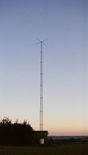
Each Adcock range station had four 134 feet (40.8 m) antenna towers erected on the corners of a 425 x 425 ft square, with an optional extra tower in the center for voice transmission and homing
. The stations emitted directional electromagnetic radiation
at 190 to 535 kHz
and 1,500 watt
s, into four quadrants. The radiation of one opposing quadrant pair was modulated (at an audio frequency of 1,020 Hz
) with a Morse code
for the letter A (· —), and the other pair with the letter N (— ·). The intersections between the quadrants defined four course lines emanating from the transmitting station, along four compass directions, where the A and N signals were of equal intensity, with their combined Morse codes merging into a steady 1,020 Hz audio tone. These course lines (also called "legs"), where only a tone could be heard, defined the airways
.
 In addition to the repeating A or N modulation signal, each transmitting station would also transmit its two-letter Morse code identifier once every thirty seconds for positive identification. The station identification would be sent twice: first on the N pair of transmitters, then on the A, to ensure coverage in all quadrants. Also, in some installations local weather conditions were periodically broadcast in voice over the range frequency, preempting the navigational signals, but eventually this was done on the central fifth tower.
The LFR was originally accompanied by airway beacon
s, which were used as a visual backup, especially for night flights. Additional "marker beacons" (low power VHF radio transmitters) were sometimes included as supplementary orientation points.
(AM) sets—were tuned to the frequency of the LFR ground transmitters, and the Morse code audio was detected and amplified into speakers, typically in headsets worn by the pilots. The pilots would constantly listen to the audio signal, and attempt to fly the aircraft along the course lines ("flying the beam"), where a uniform tone would be heard. If the signal of a single letter (A or N) became audibly distinct, the aircraft would be turned as needed so that the modulation of the two letters would overlap again, and the Morse code audio would become a steady tone. The "on course" region, where the A and N audibly merged, was approximately 3° wide, which translated into a course width of ±2.6 miles when 100 miles away from the station.
Pilots had to verify that they were tuned to the correct range station frequency by comparing its Morse code identifier against the one published on their navigation charts. They would also verify they were flying towards or away from the station, by determining if the signal level (i.e. the audible tone volume) was getting stronger or weaker, respectively.
es were normally flown near the range station, which ensured increased accuracy. When the aircraft was over the station, the audio signal disappeared, since there was no modulation signal directly above the transmitting towers. This quiet zone, called the "Cone of Silence", signified to the pilots that the aircraft was directly overhead the station, serving as a positive ground reference point for the approach procedure.
In a typical LFR instrument approach procedure, final approach
would begin over the range station, with a turn to a specific course. The pilot would descend to a specified minimum descent altitude
(MDA), and if the airport was not in sight within a specified time (based on ground speed
), a missed approach
procedure would be initiated. In the depicted Joliet, IL LFR approach procedure, minimum descent altitude could be as low as 300 feet AGL
, and required minimum visibility one mile, depending on aircraft type.
The LFR also allowed air traffic control
to instruct pilots to enter a holding pattern
"on the beam", i.e. on one of the LFR legs, with the holding fix (key turning point) over the LFR station, in the Cone of Silence
, or over one of the fan markers. The holds were used either during the en route portion of a flight or as part of the approach procedure near the terminal airport. LFR holds were more accurate than NDB
holds, since NDB holding courses
are predicated on the accuracy of the on board magnetic compass
, whereas the LFR hold was as accurate as the LFR leg, with an approximate course width of 3°.
The LFR required a complex ground installation (four to five antenna towers per station) and careful monitoring of its signals, producing directional radio waves which defined flyable airways, with only a simple AM receiver needed on board the aircraft. From its beginning in the early 1930s, the LFR was augmented with Low Frequency Non-directional beacon
s (NDBs), which were simple, single-antenna transmitters, whose radio emission pattern was uniform in all directions in the horizontal plane
. Coupled with a more complex on-board receiver, called radio direction finder
(RDF), used to detect the phase
of incoming waves, NDB allowed pilots to determine their azimuth to the transmitting station, and to navigate to or from the station in conjunction with their magnetic compass
. Early RDF receivers were costly, bulky and difficult to operate, but the simpler and less expensive ground installation allowed the easy addition of NDB based waypoint
s and approaches
, to supplement the LFR system.
Modern RDF receivers, called "automatic direction finders" are small, low cost and easy to operate, and
the NDB remains today as a supplement and backup to VOR and GPS
navigation, although it is gradually being phased out.
and night flying, it had some well known limitations and drawbacks. The course lines, which were a result of a balance between the radiation patterns from different transmitters, would fluctuate depending on weather conditions, vegetation or snow cover near the station, and even the airborne receiver's antenna angle. Under some conditions, the signals from the A quadrant would "skip" into the N quadrant (or vice-versa), causing a false "virtual course" away from any real course line. Also, thunderstorms and other atmospheric disturbances would create electromagnetic interference
to disrupt the range signals and produce crackling "static"
in the pilots' headsets.
 The LFR navigation system required, at a minimum, only a simple AM radio receiver
on board the aircraft to accurately navigate the airways under instrument meteorological conditions
, and even execute an instrument approach
to low minimums. On the downside, however, it had only four course directions per station, was sensitive to atmospheric and other types of interference and aberrations, and required pilots to listen for hours to an annoying monotonous beep, or a faint stream of Morse codes, often embedded in background "static"
. Its eventual replacement, the VHF band VOR
navigation system, had many advantages. The VOR was virtually immune to interference, had 360 available course directions, had a visual "on course" display (with no listening needed), and was far easier to use. Consequently, when the VOR system became available in the early 1950s its acceptance was rapid, and within a decade the LFR was mostly phased out. VOR itself is gradually being phased out today in favor of the far superior Global Positioning System
(GPS).
LFR. The range station—located about 10 miles north of Baker, California
—would preempt the navigational signals every 30 seconds to transmit its Morse code identifier ("RL"). The station identification would be heard once or twice, possibly with different relative amplitudes, depending on the aircraft location. Pilots would listen to and navigate by these sounds for hours while flying. Actual sounds contained "static"
, interference and other distortions, not reproduced by the simulation. Adjusting the volume would affect the effective course width. For example, in the simulated sound for "twilight" A below, where the aircraft is nearly on the beam but slightly inside the A quadrant, a low volume almost obscures the weak A sound, whereas a loud one makes it more distinct.
(See Wikipedia:Media help if you encounter problems playing these sound files.)
Radio navigation
Radio navigation or radionavigation is the application of radio frequencies to determine a position on the Earth. Like radiolocation, it is a type of radiodetermination.The basic principles are measurements from/to electric beacons, especially...
used by aircraft for instrument flying
Instrument flight rules
Instrument flight rules are one of two sets of regulations governing all aspects of civil aviation aircraft operations; the other are visual flight rules ....
in the 1930s and 1940s, until the advent of the VHF omnidirectional range
VHF omnidirectional range
VOR, short for VHF omnidirectional radio range, is a type of radio navigation system for aircraft. A VOR ground station broadcasts a VHF radio composite signal including the station's identifier, voice , and navigation signal. The identifier is typically a two- or three-letter string in Morse code...
(VOR), beginning in the late 1940s. It was used for en route navigation as well as instrument approach
Instrument approach
For aircraft operating under instrument flight rules , an instrument approach or instrument approach procedure is a series of predetermined maneuvers for the orderly transfer of an aircraft under instrument flight conditions from the beginning of the initial approach to a landing, or to a point...
es and holds
Holding (aviation)
In aviation, holding is a maneuver designed to delay an aircraft already in flight while keeping it within a specified airspace.-Implementation:...
.
Based on a network of radio towers which transmitted directional
Radiation pattern
In the field of antenna design the term radiation pattern most commonly refers to the directional dependence of the strength of the radio waves from the antenna or other source ....
radio signals, the LFR defined specific airways
Airway (aviation)
In aviation, an airway is a designated route in the air. Airways are laid out between navigational aids such as VORs, NDBs and Intersections ....
in the sky. Pilots navigated the LFR by listening to a stream of automated "A" and "N" Morse code
Morse code
Morse code is a method of transmitting textual information as a series of on-off tones, lights, or clicks that can be directly understood by a skilled listener or observer without special equipment...
s. For example, they would turn the aircraft to the right when hearing an "N" stream ("dah-dit, dah-dit, ..."), to the left when hearing an "A" stream ("di-dah, di-dah, ..."), and fly straight ahead while hearing a steady tone.
As the VOR system was phased in around the world, the LFR was gradually phased out, mostly disappearing by the 1970s. There are no remaining operational LFR facilities today. At its maximum deployment, there were nearly 400 LFR stations in the U.S. alone.
History
World War I
World War I , which was predominantly called the World War or the Great War from its occurrence until 1939, and the First World War or World War I thereafter, was a major war centred in Europe that began on 28 July 1914 and lasted until 11 November 1918...
, aviation began to expand its role into the civilian arena, starting with airmail
Airmail
Airmail is mail that is transported by aircraft. It typically arrives more quickly than surface mail, and usually costs more to send...
flights. It soon became apparent that for reliable mail delivery, as well as the passenger flights which were soon to follow, a solution was required for navigation at night and in poor visibility. In the U.S., a network of lighted beacons
Airway Beacon
An Airway beacon was a rotating light on a tower used for visual navigation by airplane pilots along a specified airway corridor. Approximately 1,500 Airway beacons were constructed, covering 18,000 miles in the U.S. to guide pilots from city to city. Construction by the Post Office and...
, similar to maritime lighthouse
Lighthouse
A lighthouse is a tower, building, or other type of structure designed to emit light from a system of lamps and lenses or, in older times, from a fire, and used as an aid to navigation for maritime pilots at sea or on inland waterways....
s, was constructed for the airmail pilots. But the beacons were useful mostly at night and in good weather, while in poor visibility conditions
Instrument meteorological conditions
Instrument meteorological conditions is an aviation flight category that describes weather conditions that require pilots to fly primarily by reference to instruments, and therefore under Instrument Flight Rules , rather than by outside visual references under Visual Flight Rules . Typically, this...
they could not be seen. Scientists and engineers realized that a radio based navigation solution would allow pilots to "see" under all flight conditions, and decided a network of directional radio beams was needed.
On September 24, 1929, then-Lieutenant (later General) James H. "Jimmy" Doolittle
Jimmy Doolittle
General James Harold "Jimmy" Doolittle, USAF was an American aviation pioneer. Doolittle served as a brigadier general, major general and lieutenant general in the United States Army Air Forces during the Second World War...
, U.S. Army, demonstrated the first "blind" flight, performed exclusively by reference to instruments and without outside visibility, and proved that instrument flying
Instrument flight rules
Instrument flight rules are one of two sets of regulations governing all aspects of civil aviation aircraft operations; the other are visual flight rules ....
was feasible. Doolittle used newly developed gyroscopic instruments—attitude indicator
Attitude indicator
An attitude indicator , also known as gyro horizon or artificial horizon, is an instrument used in an aircraft to inform the pilot of the orientation of the aircraft relative to earth. It indicates pitch and bank or roll and is a primary instrument for flight in instrument meteorological conditions...
and gyrocompass
Heading indicator
The heading indicator is a flight instrument used in an aircraft to inform the pilot of the aircraft's heading. It is sometimes referred to by its older names, the directional gyro or DG, and also direction indicator or DI.- Use :The primary means of establishing the heading in most small...
—to help him maintain his aircraft's attitude and heading, and a specially designed directional radio system to navigate to and from the airport. Doolittle's experimental equipment was purpose-built for his demonstration flights; for instrument flying to become practical, the technology had to be reliable, mass-produced and widely deployed, both on the ground and in the aircraft fleet.
There were two technological approaches for both the ground and air radio navigation components, which were being evaluated during the late 1920s and early 1930s.
On the ground, to obtain directional radio beams with a well defined navigable course, crossed loop antenna
Loop antenna
A loop antenna is a radio antenna consisting of a loop of wire, tubing, or other electrical conductor with its ends connected to a balanced transmission line...
s were used initially. The first loop-based LFR system was commissioned by the U.S. Commerce Department on June 30, 1928. But the loop antenna design suffered from poor performance, especially at night, and by 1932 the Adcock antenna
Adcock antenna
The Adcock antenna is an antenna array consisting of four equidistant vertical elements which can be used to transmit or receive directional radio waves. It was invented and patented by British engineer Frank Adcock in 1919 as British Patent No. 130,490, and has been used for a variety of...
array, which had superior accuracy, became the preferred solution and replaced the loop antennas. The U.S. Commerce Department's Aeronautics Branch
Federal Aviation Administration
The Federal Aviation Administration is the national aviation authority of the United States. An agency of the United States Department of Transportation, it has authority to regulate and oversee all aspects of civil aviation in the U.S...
referred to the Adcock solution as the "T-L Antenna" (for "Transmission Line") and did not initially mention Adcock's name.
In the air, there were also two competing designs, originating from groups of different backgrounds and needs. The Army Signal Corps, representing military aviators, preferred a solution based on a stream of audio navigation signals, constantly fed into the pilots' ears via a headset. Civilian pilots on the other hand, who were mostly airmail pilots flying cross-country to deliver the mail, felt the audio signals would be annoying and difficult to use over long flights, and preferred a visual solution, with an indicator in the instrument panel.
A visual indicator was developed based on vibrating reeds, which provided a simple panel-mounted "turn left-right" indicator. It was reliable, easy to use and more immune to erroneous signals than the competing audio based system. Pilots who had flown with both aural and visual systems strongly preferred the visual type, according to a published report. The reed-based solution was passed over by the U.S. government
Federal government of the United States
The federal government of the United States is the national government of the constitutional republic of fifty states that is the United States of America. The federal government comprises three distinct branches of government: a legislative, an executive and a judiciary. These branches and...
, however, and the audio signals became standard for decades to come.
By the 1930s the LFR network of ground-based radio transmitters, coupled with on board AM radio receivers, became a vital part of instrument flying. LFR provided navigational guidance to aircraft for en route operations and approaches, under virtually all weather conditions, helping to make consistent and reliable flight schedules a reality.
LFR remained as the main radio navigation system in the U.S. and other countries until it was gradually replaced by the much-improved VHF-based VOR technology, starting in the late 1940s. The VOR, still used today, includes a visual left-right indicator.
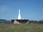
Ground
The LFR ground component consisted of a network of radio transmission stations which were strategically located around the country, often near larger airports, approximately 200 miles apart. Early LFR stations used crossed loop antennas, but later designs were all based on the Adcock vertical antenna arrayAdcock antenna
The Adcock antenna is an antenna array consisting of four equidistant vertical elements which can be used to transmit or receive directional radio waves. It was invented and patented by British engineer Frank Adcock in 1919 as British Patent No. 130,490, and has been used for a variety of...
for improved performance, especially at night.
Each Adcock range station had four 134 feet (40.8 m) antenna towers erected on the corners of a 425 x 425 ft square, with an optional extra tower in the center for voice transmission and homing
Radio direction finder
A radio direction finder is a device for finding the direction to a radio source. Due to low frequency propagation characteristic to travel very long distances and "over the horizon", it makes a particularly good navigation system for ships, small boats, and aircraft that might be some distance...
. The stations emitted directional electromagnetic radiation
Electromagnetic radiation
Electromagnetic radiation is a form of energy that exhibits wave-like behavior as it travels through space...
at 190 to 535 kHz
Hertz
The hertz is the SI unit of frequency defined as the number of cycles per second of a periodic phenomenon. One of its most common uses is the description of the sine wave, particularly those used in radio and audio applications....
and 1,500 watt
Watt
The watt is a derived unit of power in the International System of Units , named after the Scottish engineer James Watt . The unit, defined as one joule per second, measures the rate of energy conversion.-Definition:...
s, into four quadrants. The radiation of one opposing quadrant pair was modulated (at an audio frequency of 1,020 Hz
Hertz
The hertz is the SI unit of frequency defined as the number of cycles per second of a periodic phenomenon. One of its most common uses is the description of the sine wave, particularly those used in radio and audio applications....
) with a Morse code
Morse code
Morse code is a method of transmitting textual information as a series of on-off tones, lights, or clicks that can be directly understood by a skilled listener or observer without special equipment...
for the letter A (· —), and the other pair with the letter N (— ·). The intersections between the quadrants defined four course lines emanating from the transmitting station, along four compass directions, where the A and N signals were of equal intensity, with their combined Morse codes merging into a steady 1,020 Hz audio tone. These course lines (also called "legs"), where only a tone could be heard, defined the airways
Airway (aviation)
In aviation, an airway is a designated route in the air. Airways are laid out between navigational aids such as VORs, NDBs and Intersections ....
.
The LFR was originally accompanied by airway beacon
Airway Beacon
An Airway beacon was a rotating light on a tower used for visual navigation by airplane pilots along a specified airway corridor. Approximately 1,500 Airway beacons were constructed, covering 18,000 miles in the U.S. to guide pilots from city to city. Construction by the Post Office and...
s, which were used as a visual backup, especially for night flights. Additional "marker beacons" (low power VHF radio transmitters) were sometimes included as supplementary orientation points.
Air
The airborne radio receivers—initially simple Amplitude ModulationAmplitude modulation
Amplitude modulation is a technique used in electronic communication, most commonly for transmitting information via a radio carrier wave. AM works by varying the strength of the transmitted signal in relation to the information being sent...
(AM) sets—were tuned to the frequency of the LFR ground transmitters, and the Morse code audio was detected and amplified into speakers, typically in headsets worn by the pilots. The pilots would constantly listen to the audio signal, and attempt to fly the aircraft along the course lines ("flying the beam"), where a uniform tone would be heard. If the signal of a single letter (A or N) became audibly distinct, the aircraft would be turned as needed so that the modulation of the two letters would overlap again, and the Morse code audio would become a steady tone. The "on course" region, where the A and N audibly merged, was approximately 3° wide, which translated into a course width of ±2.6 miles when 100 miles away from the station.
Pilots had to verify that they were tuned to the correct range station frequency by comparing its Morse code identifier against the one published on their navigation charts. They would also verify they were flying towards or away from the station, by determining if the signal level (i.e. the audible tone volume) was getting stronger or weaker, respectively.
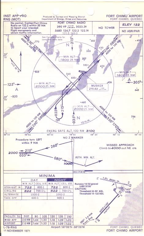
Approaches and holds
Final approach segments of LFR instrument approachInstrument approach
For aircraft operating under instrument flight rules , an instrument approach or instrument approach procedure is a series of predetermined maneuvers for the orderly transfer of an aircraft under instrument flight conditions from the beginning of the initial approach to a landing, or to a point...
es were normally flown near the range station, which ensured increased accuracy. When the aircraft was over the station, the audio signal disappeared, since there was no modulation signal directly above the transmitting towers. This quiet zone, called the "Cone of Silence", signified to the pilots that the aircraft was directly overhead the station, serving as a positive ground reference point for the approach procedure.
In a typical LFR instrument approach procedure, final approach
Final approach (aviation)
A final approach is the last leg in an aircraft's approach to landing. In aviation radio terminology, it is often shortened to "final".In a standard airport landing pattern, which is usually used under visual meteorological conditions , aircraft turn from base leg to final within one to two miles...
would begin over the range station, with a turn to a specific course. The pilot would descend to a specified minimum descent altitude
Instrument approach
For aircraft operating under instrument flight rules , an instrument approach or instrument approach procedure is a series of predetermined maneuvers for the orderly transfer of an aircraft under instrument flight conditions from the beginning of the initial approach to a landing, or to a point...
(MDA), and if the airport was not in sight within a specified time (based on ground speed
Ground speed
Ground speed is the speed of an aircraft relative to the ground. Information displayed to passengers through the entertainment system often gives the aircraft groundspeed rather than airspeed....
), a missed approach
Missed approach
Missed approach is an instrument flight rules procedure which is a standard component segment of an instrument approach. Generally, if the pilot flying or the pilot in command determines by the time the aircraft is at the decision height or missed approach point , that the runway or its...
procedure would be initiated. In the depicted Joliet, IL LFR approach procedure, minimum descent altitude could be as low as 300 feet AGL
Above ground level
In aviation and atmospheric sciences, an altitude is said to be above ground level when it is measured with respect to the underlying ground surface. This is as opposed to above mean sea level , or in broadcast engineering, height above average terrain...
, and required minimum visibility one mile, depending on aircraft type.
The LFR also allowed air traffic control
Air traffic control
Air traffic control is a service provided by ground-based controllers who direct aircraft on the ground and in the air. The primary purpose of ATC systems worldwide is to separate aircraft to prevent collisions, to organize and expedite the flow of traffic, and to provide information and other...
to instruct pilots to enter a holding pattern
Holding (aviation)
In aviation, holding is a maneuver designed to delay an aircraft already in flight while keeping it within a specified airspace.-Implementation:...
"on the beam", i.e. on one of the LFR legs, with the holding fix (key turning point) over the LFR station, in the Cone of Silence
Cone of Silence
The Cone of Silence is one of many recurring joke devices from Get Smart, an American comedy television series of the 1960s about an inept spy....
, or over one of the fan markers. The holds were used either during the en route portion of a flight or as part of the approach procedure near the terminal airport. LFR holds were more accurate than NDB
Non-directional beacon
A non-directional beacon is a radio transmitter at a known location, used as an aviation or marine navigational aid. As the name implies, the signal transmitted does not include inherent directional information, in contrast to other navigational aids such as low frequency radio range, VHF...
holds, since NDB holding courses
Course (navigation)
In navigation, a vehicle's course is the angle that the intended path of the vehicle makes with a fixed reference object . Typically course is measured in degrees from 0° clockwise to 360° in compass convention . Course is customarily expressed in three digits, using preliminary zeros if needed,...
are predicated on the accuracy of the on board magnetic compass
Compass
A compass is a navigational instrument that shows directions in a frame of reference that is stationary relative to the surface of the earth. The frame of reference defines the four cardinal directions – north, south, east, and west. Intermediate directions are also defined...
, whereas the LFR hold was as accurate as the LFR leg, with an approximate course width of 3°.
Non-directional beacons
The LFR required a complex ground installation (four to five antenna towers per station) and careful monitoring of its signals, producing directional radio waves which defined flyable airways, with only a simple AM receiver needed on board the aircraft. From its beginning in the early 1930s, the LFR was augmented with Low Frequency Non-directional beacon
Non-directional beacon
A non-directional beacon is a radio transmitter at a known location, used as an aviation or marine navigational aid. As the name implies, the signal transmitted does not include inherent directional information, in contrast to other navigational aids such as low frequency radio range, VHF...
s (NDBs), which were simple, single-antenna transmitters, whose radio emission pattern was uniform in all directions in the horizontal plane
Horizontal plane
In geometry, physics, astronomy, geography, and related sciences, a plane is said to be horizontal at a given point if it is perpendicular to the gradient of the gravity field at that point— in other words, if apparent gravity makes a plumb bob hang perpendicular to the plane at that point.In...
. Coupled with a more complex on-board receiver, called radio direction finder
Radio direction finder
A radio direction finder is a device for finding the direction to a radio source. Due to low frequency propagation characteristic to travel very long distances and "over the horizon", it makes a particularly good navigation system for ships, small boats, and aircraft that might be some distance...
(RDF), used to detect the phase
Phase (waves)
Phase in waves is the fraction of a wave cycle which has elapsed relative to an arbitrary point.-Formula:The phase of an oscillation or wave refers to a sinusoidal function such as the following:...
of incoming waves, NDB allowed pilots to determine their azimuth to the transmitting station, and to navigate to or from the station in conjunction with their magnetic compass
Compass
A compass is a navigational instrument that shows directions in a frame of reference that is stationary relative to the surface of the earth. The frame of reference defines the four cardinal directions – north, south, east, and west. Intermediate directions are also defined...
. Early RDF receivers were costly, bulky and difficult to operate, but the simpler and less expensive ground installation allowed the easy addition of NDB based waypoint
Waypoint
A waypoint is a reference point in physical space used for purposes of navigation.-Concept:Waypoints are sets of coordinates that identify a point in physical space. Coordinates used can vary depending on the application. For terrestrial navigation these coordinates can include longitude and...
s and approaches
Instrument approach
For aircraft operating under instrument flight rules , an instrument approach or instrument approach procedure is a series of predetermined maneuvers for the orderly transfer of an aircraft under instrument flight conditions from the beginning of the initial approach to a landing, or to a point...
, to supplement the LFR system.
Modern RDF receivers, called "automatic direction finders" are small, low cost and easy to operate, and
the NDB remains today as a supplement and backup to VOR and GPS
Global Positioning System
The Global Positioning System is a space-based global navigation satellite system that provides location and time information in all weather, anywhere on or near the Earth, where there is an unobstructed line of sight to four or more GPS satellites...
navigation, although it is gradually being phased out.
Limitations
Although the LFR system was used for decades as the main aeronautical navigation method during low visibilityInstrument meteorological conditions
Instrument meteorological conditions is an aviation flight category that describes weather conditions that require pilots to fly primarily by reference to instruments, and therefore under Instrument Flight Rules , rather than by outside visual references under Visual Flight Rules . Typically, this...
and night flying, it had some well known limitations and drawbacks. The course lines, which were a result of a balance between the radiation patterns from different transmitters, would fluctuate depending on weather conditions, vegetation or snow cover near the station, and even the airborne receiver's antenna angle. Under some conditions, the signals from the A quadrant would "skip" into the N quadrant (or vice-versa), causing a false "virtual course" away from any real course line. Also, thunderstorms and other atmospheric disturbances would create electromagnetic interference
Electromagnetic interference
Electromagnetic interference is disturbance that affects an electrical circuit due to either electromagnetic induction or electromagnetic radiation emitted from an external source. The disturbance may interrupt, obstruct, or otherwise degrade or limit the effective performance of the circuit...
to disrupt the range signals and produce crackling "static"
Noise (radio)
In radio reception, noise is the superposition of white noise and other disturbing influences on the signal, caused either by thermal noise and other electronic noise from receiver input circuits or by interference from radiated electromagnetic noise picked up by the receiver's antenna...
in the pilots' headsets.
Replacement by VOR
Amplitude modulation
Amplitude modulation is a technique used in electronic communication, most commonly for transmitting information via a radio carrier wave. AM works by varying the strength of the transmitted signal in relation to the information being sent...
on board the aircraft to accurately navigate the airways under instrument meteorological conditions
Instrument meteorological conditions
Instrument meteorological conditions is an aviation flight category that describes weather conditions that require pilots to fly primarily by reference to instruments, and therefore under Instrument Flight Rules , rather than by outside visual references under Visual Flight Rules . Typically, this...
, and even execute an instrument approach
Instrument approach
For aircraft operating under instrument flight rules , an instrument approach or instrument approach procedure is a series of predetermined maneuvers for the orderly transfer of an aircraft under instrument flight conditions from the beginning of the initial approach to a landing, or to a point...
to low minimums. On the downside, however, it had only four course directions per station, was sensitive to atmospheric and other types of interference and aberrations, and required pilots to listen for hours to an annoying monotonous beep, or a faint stream of Morse codes, often embedded in background "static"
Noise (radio)
In radio reception, noise is the superposition of white noise and other disturbing influences on the signal, caused either by thermal noise and other electronic noise from receiver input circuits or by interference from radiated electromagnetic noise picked up by the receiver's antenna...
. Its eventual replacement, the VHF band VOR
VHF omnidirectional range
VOR, short for VHF omnidirectional radio range, is a type of radio navigation system for aircraft. A VOR ground station broadcasts a VHF radio composite signal including the station's identifier, voice , and navigation signal. The identifier is typically a two- or three-letter string in Morse code...
navigation system, had many advantages. The VOR was virtually immune to interference, had 360 available course directions, had a visual "on course" display (with no listening needed), and was far easier to use. Consequently, when the VOR system became available in the early 1950s its acceptance was rapid, and within a decade the LFR was mostly phased out. VOR itself is gradually being phased out today in favor of the far superior Global Positioning System
Global Positioning System
The Global Positioning System is a space-based global navigation satellite system that provides location and time information in all weather, anywhere on or near the Earth, where there is an unobstructed line of sight to four or more GPS satellites...
(GPS).
Sounds
The following are simulated sounds for the Silver LakeSilver Lake, California
Silver Lake is a town that existed near the Tonopah and Tidewater Railroad, between Ludlow, California and Death Valley Junction, California, in the Mojave Desert of San Bernardino County, California....
LFR. The range station—located about 10 miles north of Baker, California
Baker, California
Baker is a census-designated place located in San Bernardino County, California, USA. As of the 2010 census, the town had a total population of 735.Baker was founded as a station on the Tonopah and Tidewater Railroad in 1908,...
—would preempt the navigational signals every 30 seconds to transmit its Morse code identifier ("RL"). The station identification would be heard once or twice, possibly with different relative amplitudes, depending on the aircraft location. Pilots would listen to and navigate by these sounds for hours while flying. Actual sounds contained "static"
Noise (radio)
In radio reception, noise is the superposition of white noise and other disturbing influences on the signal, caused either by thermal noise and other electronic noise from receiver input circuits or by interference from radiated electromagnetic noise picked up by the receiver's antenna...
, interference and other distortions, not reproduced by the simulation. Adjusting the volume would affect the effective course width. For example, in the simulated sound for "twilight" A below, where the aircraft is nearly on the beam but slightly inside the A quadrant, a low volume almost obscures the weak A sound, whereas a loud one makes it more distinct.
(See Wikipedia:Media help if you encounter problems playing these sound files.)