
Baker, California
Encyclopedia

Census-designated place
A census-designated place is a concentration of population identified by the United States Census Bureau for statistical purposes. CDPs are delineated for each decennial census as the statistical counterparts of incorporated places such as cities, towns and villages...
located in San Bernardino County
San Bernardino County, California
San Bernardino County is a county in the U.S. state of California. As of the 2010 census, the population was 2,035,210, up from 1,709,434 as of the 2000 census...
, California
California
California is a state located on the West Coast of the United States. It is by far the most populous U.S. state, and the third-largest by land area...
, USA. As of the 2010 census, the town had a total population of 735.
Baker was founded as a station on the Tonopah and Tidewater Railroad
Tonopah and Tidewater Railroad
The Tonopah and Tidewater Railroad, the T&T, was a class II railroad extending through remote reaches of the Mojave Desert from the Santa Fe Railway railhead at Ludlow, California, through Death Valley and Amargosa Valley, terminating at the Mining towns of Tonopah and Goldfield in the Great Basin...
in 1908,
and was named after Richard C. Baker
Richard C. Baker
Richard C. Baker was the British business partner of Francis Marion "Borax" Smith and eventually became president of the Pacific Coast Borax Company and the Tonopah and Tidewater Railroad....
, business partner of Francis Marion Smith
Francis Marion Smith
Francis Marion Smith was an American miner, business magnate and civic builder in the Mojave Desert, the San Francisco Bay Area, and Oakland, California.Frank Smith created the extensive interurban public transit Key System in Oakland, the East Bay,...
in building the railroad. Baker later became president of the T&T himself.
Baker was established in 1929 by Ralph Jacobus Fairbanks
Ralph Jacobus Fairbanks
Ralph Jacobus Fairbanks was an American prospector, entrepreneur and pioneer who established several towns in the Death Valley area of California, including Fairbanks Springs , Shoshone , and Baker ....
(1857-1942), who was an American prospector, entrepreneur and pioneer who established several towns in the Death Valley
Death Valley
Death Valley is a desert valley located in Eastern California. Situated within the Mojave Desert, it features the lowest, driest, and hottest locations in North America. Badwater, a basin located in Death Valley, is the specific location of the lowest elevation in North America at 282 feet below...
area of California, including Fairbanks Springs (1904-05) and Shoshone
Shoshone, California
Shoshone is a census-designated place in Inyo County, California, United States. Shoshone is located on the Tonopah and Tidewater Railroad east of Epaulet Peak, at an elevation of 1585 feet . The population was 31 at the 2010 census, down from 52 at the 2000 census.The town was founded in 1910...
(1910).
Baker's ZIP Code
ZIP Code
ZIP codes are a system of postal codes used by the United States Postal Service since 1963. The term ZIP, an acronym for Zone Improvement Plan, is properly written in capital letters and was chosen to suggest that the mail travels more efficiently, and therefore more quickly, when senders use the...
is 92309 and the community is within area code 760
Area code 760
Image:Area_code_442.svg|right|Map of California area codes in blue with 442/760 in redrect 65 82 92 100 Area code 916rect 220 242 245 256 Area code 909rect 243 274 265 287 Area code 951rect 136 323 160 338 Area code 858...
.
Geography
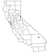
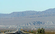
Baker is located at (35.265099, -116.074768).Baker is located in the Mojave Desert
Mojave Desert
The Mojave Desert occupies a significant portion of southeastern California and smaller parts of central California, southern Nevada, southwestern Utah and northwestern Arizona, in the United States...
at the junction of Interstate 15 and SR 127
California State Route 127
State Route 127 is a California state highway that connects Interstate 15 to Nevada State Route 373, passing through Death Valley National Park....
(Death Valley Road). Its elevation is approximately 930 feet (283.5 m) above sea level, which is much lower than either Barstow
Barstow, California
Barstow is a city in San Bernardino County, California, United States. The population was 22,639 at the 2010 census, up from 21,119 at the 2000 census. Barstow is located north of San Bernardino....
or Las Vegas
Las Vegas, Nevada
Las Vegas is the most populous city in the U.S. state of Nevada and is also the county seat of Clark County, Nevada. Las Vegas is an internationally renowned major resort city for gambling, shopping, and fine dining. The city bills itself as The Entertainment Capital of the World, and is famous...
, due to its location at the southern end of the Death Valley
Death Valley
Death Valley is a desert valley located in Eastern California. Situated within the Mojave Desert, it features the lowest, driest, and hottest locations in North America. Badwater, a basin located in Death Valley, is the specific location of the lowest elevation in North America at 282 feet below...
geological depression. The Cronese Mountains
Cronese Mountains
The Cronese Mountains are found in the Mojave Desert of San Bernardino County, California in the United States.-Geography:The small range is found north of Interstate 15, southwest of the town of Baker. The mountains are located at the northwestern edge of the Devils Playground and Mojave National...
are located southwest of the community.
According to the United States Census Bureau
United States Census Bureau
The United States Census Bureau is the government agency that is responsible for the United States Census. It also gathers other national demographic and economic data...
, the CDP covers an area of 2.7 square miles (7.0 km²), all of it land.
Demographics
The 2010 United States Census reported that Baker had a population of 735. The population densityPopulation density
Population density is a measurement of population per unit area or unit volume. It is frequently applied to living organisms, and particularly to humans...
was 273.5 people per square mile (105.6/km²). The racial makeup of Baker was 302 (41.1%) White, 1 (0.1%) African American, 5 (0.7%) Native American, 10 (1.4%) Asian, 14 (1.9%) Pacific Islander, 380 (51.7%) from other races
Race (United States Census)
Race and ethnicity in the United States Census, as defined by the Federal Office of Management and Budget and the United States Census Bureau, are self-identification data items in which residents choose the race or races with which they most closely identify, and indicate whether or not they are...
, and 23 (3.1%) from two or more races. Hispanic or Latino of any race were 502 persons (68.3%).
The Census reported that 731 people (99.5% of the population) lived in households, 4 (0.5%) lived in non-institutionalized group quarters, and 0 (0%) were institutionalized.
There were 215 households, out of which 122 (56.7%) had children under the age of 18 living in them, 106 (49.3%) were opposite-sex married couples
Marriage
Marriage is a social union or legal contract between people that creates kinship. It is an institution in which interpersonal relationships, usually intimate and sexual, are acknowledged in a variety of ways, depending on the culture or subculture in which it is found...
living together, 39 (18.1%) had a female householder with no husband present, 23 (10.7%) had a male householder with no wife present. There were 29 (13.5%) unmarried opposite-sex partnerships
POSSLQ
POSSLQ is an abbreviation for "Persons of Opposite Sex Sharing Living Quarters," a term coined in the late 1970s by the United States Census Bureau as part of an effort to more accurately gauge the prevalence of cohabitation in American households....
, and 1 (0.5%) same-sex married couples or partnerships. 28 households (13.0%) were made up of individuals and 4 (1.9%) had someone living alone who was 65 years of age or older. The average household size was 3.40. There were 168 families
Family (U.S. Census)
A family or family household is defined by the United States Census Bureau for statistical purposes as "a householder and one or more other people related to the householder by birth, marriage, or adoption. They do not include same-sex married couples even if the marriage was performed in a state...
(78.1% of all households); the average family size was 3.74.
The population was spread out with 277 people (37.7%) under the age of 18, 80 people (10.9%) aged 18 to 24, 236 people (32.1%) aged 25 to 44, 121 people (16.5%) aged 45 to 64, and 21 people (2.9%) who were 65 years of age or older. The median age was 26.1 years. For every 100 females there were 113.7 males. For every 100 females age 18 and over, there were 111.1 males.
There were 303 housing units at an average density of 112.7 per square mile (43.5/km²), of which 116 (54.0%) were owner-occupied, and 99 (46.0%) were occupied by renters. The homeowner vacancy rate was 1.7%; the rental vacancy rate was 20.8%. 414 people (56.3% of the population) lived in owner-occupied housing units and 317 people (43.1%) lived in rental housing units.
Economy
Baker's economy is based primarily on tourismTourism
Tourism is travel for recreational, leisure or business purposes. The World Tourism Organization defines tourists as people "traveling to and staying in places outside their usual environment for not more than one consecutive year for leisure, business and other purposes".Tourism has become a...
. The town is frequently used as a rest stop by drivers on Interstate 15
Interstate 15
Interstate 15 is the fourth-longest north–south Interstate Highway in the United States, traveling through the states of California, Nevada, Arizona, Utah, Idaho, and Montana from San Diego to the Canadian border...
between Los Angeles
Los Angeles, California
Los Angeles , with a population at the 2010 United States Census of 3,792,621, is the most populous city in California, USA and the second most populous in the United States, after New York City. It has an area of , and is located in Southern California...
and Las Vegas
Las Vegas, Nevada
Las Vegas is the most populous city in the U.S. state of Nevada and is also the county seat of Clark County, Nevada. Las Vegas is an internationally renowned major resort city for gambling, shopping, and fine dining. The city bills itself as The Entertainment Capital of the World, and is famous...
. Baker is approximately 90 miles (144.8 km) southwest of Las Vegas. It is the last town for those traveling on SR 127 north to Death Valley National Park
Death Valley National Park
Death Valley National Park is a national park in the U.S. states of California and Nevada located east of the Sierra Nevada in the arid Great Basin of the United States. The park protects the northwest corner of the Mojave Desert and contains a diverse desert environment of salt-flats, sand dunes,...
or south to the Mojave National Preserve
Mojave National Preserve
Mojave National Preserve is located in the Mojave Desert of San Bernardino County, California, USA, between Interstate 15 and Interstate 40. The preserve was established October 31, 1994 with the passage of the California Desert Protection Act by the US Congress...
.
The town's most prominent feature is a 134-foot (41m) thermometer
Thermometer
Developed during the 16th and 17th centuries, a thermometer is a device that measures temperature or temperature gradient using a variety of different principles. A thermometer has two important elements: the temperature sensor Developed during the 16th and 17th centuries, a thermometer (from the...
, known as the "world's tallest thermometer
World's tallest thermometer
The world's tallest thermometer is a landmark located in Baker, California, USA.It is technically an electric sign rather than a tall thermometer. However, it exists as a tribute to the record 134 degrees Fahrenheit recorded in nearby Death Valley on July 10, 1913...
," visible for miles. It is located at the Big Boy
Big Boy
The name Big Boy has been applied to:* Big Boy , an American restaurant chain* Union Pacific Big Boy, a class of steam locomotives* Big Boy , Puerto Rican hip hop/reggaeton artist...
restaurant. Its height commemorates the hottest temperature ever recorded in the United States
United States
The United States of America is a federal constitutional republic comprising fifty states and a federal district...
, 134 °F (56.7 °C), measured in nearby Death Valley
Death Valley
Death Valley is a desert valley located in Eastern California. Situated within the Mojave Desert, it features the lowest, driest, and hottest locations in North America. Badwater, a basin located in Death Valley, is the specific location of the lowest elevation in North America at 282 feet below...
in 1913. Summer temperatures in Baker routinely exceed 110 °F (43.3 °C); 2007 saw a record of 125 °F (51.7 °C). In recent years Baker has experienced hard times, with casinos just across the Nevada border at Primm
Primm, Nevada
Primm is a tiny community in Clark County, Nevada, United States, primarily notable for its position straddling Interstate 15 where it crosses the border between California and Nevada...
and Jean, Nevada
Jean, Nevada
Jean is a small commercial town in Clark County, Nevada, located approximately north of the Nevada-California state line along Interstate 15. Las Vegas is located about to the north...
taking much of its motel
Motel
A motor hotel, or motel for short, is a hotel designed for motorists, and usually has a parking area for motor vehicles...
trade .
The prices of gasoline are cheaper at the west end than at the east end, where most travelers first come to.
Baker Airport
Baker Airport
Baker Airport is a public airport located two miles northwest of the central business district of Baker, in San Bernardino County, California, United States. It is owned by the U.S...
is a small facility owned by the U.S. Department of the Interior, Bureau of Land Management
Bureau of Land Management
The Bureau of Land Management is an agency within the United States Department of the Interior which administers America's public lands, totaling approximately , or one-eighth of the landmass of the country. The BLM also manages of subsurface mineral estate underlying federal, state and private...
.
Baker is also the start of the annual Baker To Vegas Challenge Cup Relay race
Appearances in films and television
In 1991 the town was the setting for a skit on Fox's comedy show Totally Hidden Video.It is referenced in the film Fear and Loathing in Las Vegas
Fear and Loathing in Las Vegas (film)
Fear and Loathing in Las Vegas is a 1998 American drama film directed by Terry Gilliam, starring Johnny Depp as Raoul Duke and Benicio del Toro as Dr. Gonzo. It was adapted from Hunter S. Thompson's 1971 novel of the same name....
as a stop for Raoul Duke on his way back from Las Vegas going to Los Angeles.
The surrounding desert areas in Disney's Dinosaur
Dinosaur (film)
Dinosaur is a 2000 American computer-animated film produced by Walt Disney Feature Animation and released by Walt Disney Pictures on May 19, 2000, and is the 39th animated feature in the Walt Disney Animated Classics series...
were shot here.
It is a major setting of the 2003 science-fiction film The Big Empty
The Big Empty
The Big Empty is a 2003 science-fiction film directed and written by Steve Anderson. It stars Jon Favreau as a struggling actor with a bizarre request from his neighbor to deliver a suitcase that he cannot open...
.
An episode of the Food Network
Food Network
Food Network is a television specialty channel that airs both one-time and recurring programs about food and cooking. Scripps Networks Interactive owns 70 percent of the network, with Tribune Company controlling the remaining 30 percent....
show Diners, Drive-Ins and Dives
Diners, Drive-Ins and Dives
Diners, Drive-Ins and Dives is an American food television series that premiered in November 2006 on the Food Network. Produced by Page Productions, the program stars and is hosted by Guy Fieri...
featured the Mad Greek's Diner in Baker.
Baker and the surrounding area were featured in two episodes of Gene Simmons Family Jewels
Gene Simmons Family Jewels
Gene Simmons Family Jewels is an American reality television series that premiered on A&E on August 7, 2006. The show follows the life of KISS bassist and vocalist Gene Simmons, his longtime partner Shannon Tweed, and their two children, Nick and Sophie....
when Gene Simmons
Gene Simmons
Gene Simmons is an Israeli-American entrepreneur, singer-songwriter, actor, and rock bassist. Known as "The Demon", he is the bassist/vocalist of Kiss, a hard rock band he co-founded in the early 1970s.-Early life:...
broke down outside of Baker on Route 127. Episodes 5 and 6 of season 3 ran in March 2008 and featured the town.
Although not shown on screen, Baker was indirectly referenced in National Lampoon's Vegas Vacation, in which Audrey Griswold (Marisol Nichols
Marisol Nichols
Marisol Nichols is an American actress best known for her role in the sixth season of 24 as Special Agent Nadia Yassir.-Early life:...
) tells her family that her new-found friends want to take her "to see the world's biggest thermometer."
Attractions
- Dumont DunesDumont DunesDumont Dunes is an area of the Mojave Desert containing large sand dunes, located approximately 31 miles north of Baker, California on California State Route 127. Bordered by steep volcanic hills and the slow running Amargosa River, the region is easily recognized from a distance by its distinctive...
Off-Highway Vehicle Area http://www.blm.gov/ca/st/en/fo/barstow/dumont.html, a popular area for ATVAll-terrain vehicleAn all-terrain vehicle , also known as a quad, quad bike, three wheeler, or four wheeler, is defined by the American National Standards Institute as a vehicle that travels on low pressure tires, with a seat that is straddled by the operator, along with handlebars for steering control...
riders. Weekly and Annual passes can purchased online at Dumont Dunes Permits.
- Just a few miles to the west along I-15 lies the exit for ZzyzxZzyzx, CaliforniaZzyzx, California , formerly Camp Soda and Soda Springs, is a settlement in San Bernardino County, California. It is the former site of the Zzyzx Mineral Springs and Health Spa and now the site of the Desert Studies Center...
Road. This dirt road leads to Soda Springs, the site of the health resort established by Curtis Springer in the late 1940s and now the Desert Study Center maintained by California State UniversityCalifornia State UniversityThe California State University is a public university system in the state of California. It is one of three public higher education systems in the state, the other two being the University of California system and the California Community College system. It is incorporated as The Trustees of the...
.
- A yearly race is held called "The Challenge Cup Relay: Baker to Vegas" or commonly referred as "Baker to Vegas" where law enforcement primarily LAPD do a relay race from Baker, CA to Las Vegas, NV. It has garnished considerable reputation and attracts law enforcement agencies nationally and even internationally to do the relay race. Baker to Vegas
Transportation
Amtrak's Thruway Motorcoach had a stop located at a Jack in the Box restaurant and ShellRoyal Dutch Shell
Royal Dutch Shell plc , commonly known as Shell, is a global oil and gas company headquartered in The Hague, Netherlands and with its registered office in London, United Kingdom. It is the fifth-largest company in the world according to a composite measure by Forbes magazine and one of the six...
gas station at 72352 Baker Blvd., and its Amtrak
Amtrak
The National Railroad Passenger Corporation, doing business as Amtrak , is a government-owned corporation that was organized on May 1, 1971, to provide intercity passenger train service in the United States. "Amtrak" is a portmanteau of the words "America" and "track". It is headquartered at Union...
station code was BKR, but the stop was discontinued in November 2010. Low ridership and cost savings were cited as the reason for discontinuing the stop, but the Amtrak bus can still be seen driving down the freeway from the bus stop, even though it no longer stops.
External links
- Baker Chamber of Commerce
- A history of Baker
- Pilgrims in the Desert - a book on the history of Baker
- Mojave National Preserve
- Baker To Vegas Relay