

Airway Beacon
Encyclopedia
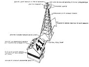
An Airway beacon was a rotating light on a tower used for visual navigation by airplane pilots along a specified airway corridor. Approximately 1,500 Airway beacons were constructed, covering 18,000 miles (29,000 km) in the U.S. to guide pilots from city to city. Construction by the Post Office and the U.S. Department of Commerce occurred between 1923 and 1933. They were spaced 10 miles (16 km) apart and featured a 24 inch (610 mm) parabolic mirror and a 110-volt, 1000 watt lamp. In clear weather they could be seen for 40 miles (64 km). The beacons rotated at 6 rpm, creating a flash every 10 seconds for 1/10 second duration. The Saint Paul
, Minnesota
beacon sits on top of a 110 foot (34 m) steel tower in Indian Mounds Park. The Low Frequency Radio Range
system began to replace this visual system in 1929. The last visual airway beacon was supposedly shut down in 1973, however fourteen airway beacons are still operating in Western Montana, and are charted on the Great Falls
sectional chart
. They are maintained by the Montana Department of Aeronautics and were transferred to the state in 1973.
 The beacons were spaced 10 miles apart, each one was identified with a number, and they flashed the Morse code
of one of 10 letters: W, U, V, H, R, K, D, B, G or M. The letters represented the digits of 1 through 10 (W = 1, ..., M = 10), and the beacons along an airway were numbered sequentially. To help remember the letters and their sequence number, pilots memorized the following phrase: "When Undertaking Very Hard Routes, Keep Direction By Good Methods." The beacons were depicted on navigation charts along with their number and Morse code. As example, beacon number 15 would have a code digit of 5 (the units digit), hence the letter R, and Morse code: "dit dah dit" (.-.).
Saint Paul, Minnesota
Saint Paul is the capital and second-most populous city of the U.S. state of Minnesota. The city lies mostly on the east bank of the Mississippi River in the area surrounding its point of confluence with the Minnesota River, and adjoins Minneapolis, the state's largest city...
, Minnesota
Minnesota
Minnesota is a U.S. state located in the Midwestern United States. The twelfth largest state of the U.S., it is the twenty-first most populous, with 5.3 million residents. Minnesota was carved out of the eastern half of the Minnesota Territory and admitted to the Union as the thirty-second state...
beacon sits on top of a 110 foot (34 m) steel tower in Indian Mounds Park. The Low Frequency Radio Range
Low Frequency radio range
The low-frequency radio range , also known as the four-course radio range, LF/MF four-course radio range, A-N radio range, Adcock radio range, or commonly "the range", was the main navigation system used by aircraft for instrument flying in the 1930s and 1940s, until the advent of the VHF...
system began to replace this visual system in 1929. The last visual airway beacon was supposedly shut down in 1973, however fourteen airway beacons are still operating in Western Montana, and are charted on the Great Falls
Great Falls, Montana
Great Falls is a city in and the county seat of Cascade County, Montana, United States. The population was 58,505 at the 2010 census. It is the principal city of the Great Falls, Montana Metropolitan Statistical Area, which encompasses all of Cascade County...
sectional chart
Sectional Chart
In United States aviation, a sectional chart, often called sectional for short, is a type of aeronautical chart designed for navigation under visual flight rules.-Overview:...
. They are maintained by the Montana Department of Aeronautics and were transferred to the state in 1973.
Identification
Morse code
Morse code is a method of transmitting textual information as a series of on-off tones, lights, or clicks that can be directly understood by a skilled listener or observer without special equipment...
of one of 10 letters: W, U, V, H, R, K, D, B, G or M. The letters represented the digits of 1 through 10 (W = 1, ..., M = 10), and the beacons along an airway were numbered sequentially. To help remember the letters and their sequence number, pilots memorized the following phrase: "When Undertaking Very Hard Routes, Keep Direction By Good Methods." The beacons were depicted on navigation charts along with their number and Morse code. As example, beacon number 15 would have a code digit of 5 (the units digit), hence the letter R, and Morse code: "dit dah dit" (.-.).