

List of municipal roads in Greater Sudbury
Encyclopedia
Ontario
Ontario is a province of Canada, located in east-central Canada. It is Canada's most populous province and second largest in total area. It is home to the nation's most populous city, Toronto, and the nation's capital, Ottawa....
. Municipal roads in Greater Sudbury are generally numbered with odd numbers for east-west routes and even numbers for north-south routes.
The city of Greater Sudbury is the only census division in Northern Ontario
Northern Ontario
Northern Ontario is a region of the Canadian province of Ontario which lies north of Lake Huron , the French River and Lake Nipissing. The region has a land area of 802,000 km2 and constitutes 87% of the land area of Ontario, although it contains only about 6% of the population...
which maintains a system of numbered roads. County or municipal road systems otherwise exist only in Southern Ontario
Southern Ontario
Southern Ontario is a region of the province of Ontario, Canada that lies south of the French River and Algonquin Park. Depending on the inclusion of the Parry Sound and Muskoka districts, its surface area would cover between 14 to 15% of the province. It is the southernmost region of...
; in the rest of the Northern region, provincially-maintained secondary highways serve a similar function. Several of the city's municipal roads were also numbered as secondary highways prior to the creation of the current municipal road system.
Prior to the amalgamation of the current city of Greater Sudbury, the numbered road system was maintained by the Regional Municipality of Sudbury, and the roads were designated as regional, rather than municipal, roads.
| Number | Names | Western/Southern Terminus | Eastern/Northern Terminus | Major Communities | Comments |
|---|---|---|---|---|---|
| 3 | Bay Street | MR 4 | MR 55 | Whitefish | Crosses over but does not interchange with Highway 17, just east of the Highway 17/MR 55 intersection. |
| 4 | Fairbank Lake Road | Highway 17 | Intersection of Wickie Road and Park Road | Worthington | Travels through the ghost town Ghost town A ghost town is an abandoned town or city. A town often becomes a ghost town because the economic activity that supported it has failed, or due to natural or human-caused disasters such as floods, government actions, uncontrolled lawlessness, war, or nuclear disasters... of Victoria Mines. Formerly Highway 658 |
| 5 | Spanish River Road | municipal boundary with township of Nairn and Hyman Nairn and Hyman, Ontario Nairn and Hyman is a township in the Canadian province of Ontario. The township, located in the Sudbury District, borders on the southwestern city limits of Greater Sudbury... |
RR 4 in Worthington | Turbine | An alternate route to RR 55 and Highway 17, also links RR 4 and RR 3 to Highway 17. At the western city limits, the roadway continues as McIntyre Street in Nairn Centre. |
| 8 | Nickel Street, Third Avenue, Mine Street | Highway 144 | Mine Road/Warsaw Road | Onaping, Levack | Main road into Onaping and Levack. Formerly Highway 544 |
| 10 | Panache Lake Road | marina at Lake Panache Lake Panache Lake Panache is a lake in the Canadian province of Ontario. It is located in the Sudbury District, although a small portion of the lake lies within the southernmost city limits of Greater Sudbury, approximately 10 kilometres south of the community of Whitefish.The lake's westernmost point lies... |
MR 55 | Whitefish | Formerly Highway 549 |
| 12 | Pilon Crescent, Simmons Road, Gordon Lake Road | MR 13 | Highway 144 | Larchwood | Gordon Lake Road (MR 12) ends at Vermilion Lake Road (MR 13) Greater Sudbury Road 13 Greater Sudbury Road 13, also known as Vermilion Lake Road, is a municipal road in the city of Greater Sudbury, Ontario, Canada. It was voted as the worst road in Ontario in the Canadian Automobile Association's annual Ontario's Worst Roads survey in 2007... near the Vermilion River bridge and continues south as a private road known as the Lockerby Mine Access Road to MR 3 near Whitefish. |
 13 13 |
Vermilion Lake Road Greater Sudbury Road 13 Greater Sudbury Road 13, also known as Vermilion Lake Road, is a municipal road in the city of Greater Sudbury, Ontario, Canada. It was voted as the worst road in Ontario in the Canadian Automobile Association's annual Ontario's Worst Roads survey in 2007... |
Brosseau Street | Highway 144 | Larchwood, Hull | Listed as Ontario's Worst Road in October 2007. |
| 14 | Errington Avenue, Main Street | Highway 144 | MR 15 | Chelmsford | |
| 15 | Municipal Road 15, Main Street | Intersection of Highway 144 and MR 35 | MR 80 | Chelmsford, Val Caron | Formerly Highway 634 |
| 18 | Montée Rouleau (Rouleau Rise, or Rouleau Way), Gagnon Street | MR 35 | MR 15 | Azilda | |
| 21 | Notre Dame Street | MR 35 | MR 35 | Azilda | Travels through the community of Azilda |
| 24 | Municipal Road 24 | MR 55 | Highway 144 | Lively | Passes by the ghost town of Creighton Mine. Formerly Highway 536 |
| 30 | Power Street, Godfrey Drive, Clarabelle Mine Road (Clarabelle Mill Road) | MR 55 | MR 35 | Copper Cliff | The Clarabelle Mine Rd., or known as "Clarabelle Mill Road" segment is owned and maintained by CVRD Inco. The road has recently been closed to the public in the spring of 2007. |
| 32 | Balsam Street | MR 55 | MR 30 | Copper Cliff | |
| 34 | Big Nickel Mine Road | Interchange with MR 55 | MR 35 | Gatchell/Little Britain | Big Nickel Big Nickel The Big Nickel is a nine-metre replica of a 1951 Canadian nickel, located at the grounds of Dynamic Earth in Sudbury, Ontario, Canada... is located on this road; effectively a two-lane freeway Two-lane freeway A two-lane expressway is an expressway with only one lane in each direction, and usually no median barrier. It may be built that way because of constraints, or may be intended for expansion once traffic volumes rise. The term super two is often used by roadgeeks for this type of road, but traffic... as it has no intersections except its termini and the entrance to Dynamic Earth Dynamic Earth Dynamic Earth is an interactive science museum in Greater Sudbury, Ontario, Canada. Owned and operated by Science North, Dynamic Earth is an earth sciences museum which builds on the city's mining heritage, focusing principally on geology and mining history exhibitions.The centre, which opened in... . Listed on new eastbound signage on MR 55 as Big Nickel Road. On May 7, 2004 the Big Nickel Mine Rd. bridge collapsed on a roadway below known as Lorne Street during the reconstruction of the bridge. No one was hurt in the incident. |
| 35 | Elm Street | MR 55 | Intersection of Highway 144 and MR 15 | Chelmsford, Azilda, Downtown | Former routing of Highway 144, until opening of the city's Northwest Bypass in 1986. Historic Murray Mine Murray Mine Murray Mine is a defunct nickel and copper mine in Greater Sudbury, Ontario. It was the site of the original ore discovery that led to the launch of mining operations in the Sudbury area.... site located on this road. A section of Municipal Road 35 between the eastern intersection of Notre Dame Street (Municipal Road 21) in Azilda to Highway 144 in Chelmsford is currently a two-lane highway. There are plans to widen that section of highway, although no date has been announced. |
| 37 | Kelly Lake Drive, Southview Drive, Bouchard Drive | MR 55 | MR 46 | Lockerby/Robinson Robinson, Ontario Robinson is a railway point and unincorporated place just west of an arm of Marchington Lake on the Sturgeon River in Unorganized Kenora District in northwestern Ontario, Canada.... |
|
| 38 | Regent Street, Beatty Street | Intersection with MR 55 and MR 46 | Intersection with MR 42 and MR 58 | Little Britain | Basically an extension of MR 46 and MR 58 |
| 39 | Ramsey Lake Road | MR 80 | Kirkwood Drive | south shore of Ramsey Lake | Science North Science North Science North is an interactive science museum in Greater Sudbury, Ontario, Canada.The complex, which is Northern Ontario's most popular tourist attraction, consists of two snowflake-shaped buildings on the southwestern shore of Lake Ramsey, just south of the city's downtown core, as well as a... is located near this road's western terminus at MR 80, while Laurentian University Laurentian University Laurentian University , was incorporated on March 28, 1960, is a mid-sized bilingual university in Greater Sudbury, Ontario, Canada.... is located near the eastern terminus. |
| 40 | Martindale Road | Intersection of MR 40, MR 46 and MR 47 | MR 55 | Robinson Robinson, Ontario Robinson is a railway point and unincorporated place just west of an arm of Marchington Lake on the Sturgeon River in Unorganized Kenora District in northwestern Ontario, Canada.... |
Basically an extension of MR 47 |
| 42 | Turner Avenue, Frood Road, Elm Street | MR 71 | MR 67 | Downtown/Donovan/Northern Heights | Has a brief concurrency Concurrency (road) A concurrency, overlap, or coincidence in a road network is an instance of one physical road bearing two or more different highway, motorway, or other route numbers... with MR 55; cannot be fully travelled as a portion of Turner Avenue on CVRD Inco company land has been closed to through traffic. Access road to Frood Mine Frood Mine Frood-Stobie Mine is a nickel mine in Greater Sudbury, Ontario, Canada.During World War II, Frood Mine alone accounted for a full 40 per cent of all the nickel used in Allied artillery production. In 1989, Frood Mine shared the John T... . |
| 43 | Ontario Street, McLeod Street, Hyland Drive | MR 40 | MR 46 | Gatchell to Lake Ramsey Lake Ramsey Lake Ramsey is a lake in Sudbury, Ontario, located near the city's downtown core. Until 2001, Lake Ramsey was listed by the Guinness Book of World Records as the world's largest lake located entirely within the boundaries of a single city, but when the Regional Municipality of Sudbury was... |
|
| 45 | York Street | MR 46 | MR 80 | near downtown | |
| 46 | Regent Street | Interchange with Highway 69 Ontario Highway 69 King's Highway 69, commonly referred to as Highway 69, is a major north–south highway in the central area of the Canadian province of Ontario, linking Highway 400 north of Parry Sound with Sudbury... and Highway 17 |
Intersection with MR 55 and MR 38 | Lo-Ellen/Four Corners/Lockerby | Basically an extension of MR 38 |
| 47 | Walford Road | Intersection of MR 40 and MR 46 | MR 80 | Lockerby | Basically an extension of MR 40 |
| 49 | Brady Street | MR 38 | MR 55 | Downtown | |
| 51 | Larch Street | MR 67 | MR 49 | Downtown | |
| 53 | Cedar Street | MR 67 | MR 49 | Downtown | |
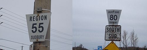
| 55 Greater Sudbury Road 55 Sudbury Municipal Road 55 is a municipal road in the city of Greater Sudbury, Ontario, Canada. Extending from Whitefish to Coniston under a variety of street names, the road's entire length is a former alignment of Highway 17 and the Trans-Canada Highway.... |
The Kingsway, Old Highway 17, Elm Street, Lorne Street | Highway 17, west of Whitefish | Highway 17, 3 km west of Coniston | Whitefish, Naughton, Lively, Copper Cliff, Gatchell, Downtown, Minnow Lake, Coniston | Former alignment of Highway 17. Surrendered this designation in Walden with the construction of freeway alignment in the early 1980s, and in the old city of Sudbury when the Southeast Bypass Southwest and Southeast Bypasses (Sudbury) The Southwest Bypass and Southeast Bypass are two separately-constructed roads in the city of Greater Sudbury, Ontario, that form a loop around the southern end of the city's urban core for traffic travelling on Highway 17, a route of the Trans-Canada Highway... was constructed in 1995. Is a dual carriageway Dual carriageway A dual carriageway is a class of highway with two carriageways for traffic travelling in opposite directions separated by a central reservation... for part of its length. |
| 58 | Kathleen Street | Intersection of MR 42 and MR 38 | MR 80 | Donovan/Flour Mill | Basically an extension of MR 38 |
| 60 | Morin Avenue, Jean Street, MacKenzie Street | MR 61 | MR 80 | Flour Mill | |
| 61 | St. Anne Road | Intersection of Mackenzie Street and MR 67 | MR 80 | Downtown | |
| 63 | College Street | Intersection of 35/55 | MR 58 | Downtown | |
| 66 | Barrydowne Road | MR 55 | MR 73 | New Sudbury | Turns into MR 73 |
| 67 | Elgin Street, Howey Drive, Bancroft Drive, Government Road, Allan Street | Intersection with MR 55 and MR 61 | MR 55/42 | Downtown, Brodie, Minnow Lake, Adamsdale, Coniston | |
| 68 | Auger Avenue | MR 86 | MR 71 | New Sudbury | |
| 70 | Bancroft Drive | MR 67 | MR 55 | Minnow Lake | |
| 71 | Lasalle Boulevard | Interchange with MR 35 | MR 86 | New Sudbury | |
| 72 | Second Avenue | MR 67 | Intersection of MR 55 and MR 86 | Minnow Lake | Continues as MR 86 |
| 73 | Maley Drive | MR 66 | MR 86 | New Sudbury | Turns into MR 66; extension to MR 71 (near Collège Boréal Collège Boréal Collège Boréal is a francophone College of Applied Arts and Technology based and with its principal campus in Sudbury, Ontario, Canada. The college also has satellite campuses in Hearst, Kapuskasing, Timmins, Temiskaming Shores, Toronto and West Nipissing, as well as a network of access centres... and MR 80) is planned. |
| 74 | Moonlight Beach Road | MR 67 | MR 55 | Adamsdale | |
| 80 | Long Lake Road, Paris Street, Notre Dame Avenue (Sudbury), Desmarais Road, Kenneth Drive, Notre Dame Avenue (Hanmer), Cote Boulevard, Capreol Road | Intersection of Dew Drop Road and Tilton Lake Road | MR 85 | Four Corners, Downtown, Val Caron, Val Thérèse, Hanmer | Route from Desmarais Road north to Capreol Road is also informally called "Highway 69 North Ontario Highway 69 King's Highway 69, commonly referred to as Highway 69, is a major north–south highway in the central area of the Canadian province of Ontario, linking Highway 400 north of Parry Sound with Sudbury... ". It was at one time part of the provincial highway's route, but was downloaded to the Region in the early 1980s. The Long Lake Road portion (from Four Corners to Dew Drop Road) was once Provincial Highway 543. |
| 84 | Capreol Road, Selwood Avenue, Milnet Road | MR 80 | Dead-end in the woods at the Greater Sudbury/Sudbury District Sudbury District, Ontario The Sudbury District is a district in Northeastern Ontario in the Canadian province of Ontario. It was created in 1894 from townships of eastern Algoma District and west Nipissing District.... border |
Hanmer, Capreol Capreol, Ontario Capreol is a community in the Ontario city of Greater Sudbury. From 1918 to 2000, Capreol existed as an independent town, situated on the Vermilion River.... , Selwood |
The ghost town of Milnet can easily be reached by turning onto a sideroad and driving for roughly 1 km. Part from Milnet to Selwood Mine was part of Highway 806, and the rest of the road was part of former Highway 545. |
| 85 | Radar Road | MR 86 | MR 80 | Hanmer | |
| 86 | Falconbridge Highway, Skead Road | Intersection of MR 55 and 72 | Skead | New Sudbury, Garson, Skead | Has an old diversion (Old Skead Road). Continues as MR 72. Sudbury Airport is located on this road. Formerly Highway 541 |
| 88 | Elmview Drive | MR 80 | Dominion Drive | Hanmer | |
| 89 | Longyear Drive | MR 86 | Edison Road | Falconbridge | |
| 90 | Garson-Coniston Road | Highway 17 | MR 86 | Garson, Coniston | |
| 93 | Second Avenue | MR 67 | Highway 17 | Coniston | |
| 96 | Desmarais Road | MR 80 | Intersection with Nelson Lake Road and Frenchman Lake Road | Val Thérèse | |
| 97 | Capreol Lake Road | MR 84 | Intersection of 4th Fire Road, 5th Fire Road, and 6th Fire Road, half-way between Capreol Capreol, Ontario Capreol is a community in the Ontario city of Greater Sudbury. From 1918 to 2000, Capreol existed as an independent town, situated on the Vermilion River.... and the Wahnapitae 11 Indian Reserve |
Capreol Capreol, Ontario Capreol is a community in the Ontario city of Greater Sudbury. From 1918 to 2000, Capreol existed as an independent town, situated on the Vermilion River.... |
|
 537 537 |
Municipal Road 537 | Highway 537 Highway 537 (Ontario) Secondary Highway 537, commonly referred to as Highway 537, is a provincially maintained highway in the Canadian province of Ontario. The highway is in length, connecting Highway 69 near Wanup with Finni Road. It once continued further to intersect Highway 17 in Wahnapitae, but was truncated... at Finni Road |
Highway 17 | Wahnapitae | Formerly part of Highway 537. |