

List of county routes in Rockland County, New York (76-118A)
Encyclopedia
_map.png)
Rockland County, New York
Rockland County is a suburban county 15 miles to the northwest of Manhattan and part of the New York City Metropolitan Area, in the U.S. state of New York. It is the southernmost county in New York west of the Hudson River, and the smallest county in New York outside of New York City. The...
highway department. Across the county, routes are numbered such that odd-numbered routes are north–south and increase in number from east to west, while even-numbered routes are east–west and increase from south to north.
There are 25 routes in this segment, the lowest being Route 76 and the highest being Route 118A. The farthest north route is Route 118 in Tomkins Cove
Tomkins Cove, New York
Tomkins Cove is an unincorporated hamlet in the Town of Stony Point Rockland County, New York, United States located north of Stony Point; east of Harriman State Park; south of Doodletown and west of the Hudson River. It is located north-northwest of New York City. The population is approximately...
, while the farthest south is Route 89 in Airmont
Airmont, New York
Airmont is a village in the town of Ramapo, Rockland County, New York, United States located north of the state of New Jersey; east of Suffern; south of Montebello and west of Chestnut Ridge. The population was 7,799 at the 2000 census....
. The farthest west is Route 97 in Ramapo
Ramapo, New York
Ramapo , formerly known as New Hempstead and then Hampstead, is a town in Rockland County, New York, United States located north of New Jersey; southeast of Orange County, New York; south of the Town of Haverstraw and west of the Town of Clarkstown and the Town of Orangetown...
and the farthest east is Route 76 in New City
New City, New York
New City is a hamlet , in the Town of Clarkstown Rockland County, New York, United States, part of the New York Metropolitan Area. The hamlet is a suburb of New York City, located 18 miles north of the city at the closest point, Riverdale, The Bronx...
. The longest route is Route 80, stretching for 10.4 miles (16.7 km) while the shortest route is Route 98A at a short, .07 of a mile.
| Rockland (NY) County Routes (76–118A) |
|---|
| CR 76 • CR 80 • CR 80A • CR 81 • CR 83 • CR 84 • CR 85 • CR 86 • CR 89 • CR 90 • CR 93 • CR 94 • CR 95 • CR 97 • CR 98 • CR 98A • CR 100 • CR 106 • CR 108 • CR 109 • CR 110 • CR 112 • CR 118 • CR 118A |
| Other lists: CRs 1–38 • CRs 41–75 |
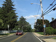
Route 76

Rockland County, New York
Rockland County is a suburban county 15 miles to the northwest of Manhattan and part of the New York City Metropolitan Area, in the U.S. state of New York. It is the southernmost county in New York west of the Hudson River, and the smallest county in New York outside of New York City. The...
.
Route 76 begins at CR 33, and ends at Main Street in downtown New City
New City, New York
New City is a hamlet , in the Town of Clarkstown Rockland County, New York, United States, part of the New York Metropolitan Area. The hamlet is a suburb of New York City, located 18 miles north of the city at the closest point, Riverdale, The Bronx...
. CR 76 runs exclusively in New City. CR 76 allows drivers to cut from Little Tor Road down into the central part of New City. CR 76 is book ended by churches at both of its termini. Park Evangelical Free Church is located at CR 33, and St. Paul's Lutheran Church is located on Main Street. CR 76 passes New City Park early in its route, which includes a private, man-made lake for local residents to swim in. CR 76 comes close to Main Street's southern terminus at NY 304
New York State Route 304
New York State Route 304 is a New York State Route that is entirely located in Central Rockland County. NY 304 begins at the New Jersey-New York border in Pearl River, New York, and ends at US 9W. Though it crosses both the New York State Thruway and the Palisades Interstate...
just south of the downtown business district of New City. CR 76 is one of the shortest Rockland County routes, but unlike the other short ones, it is a highly traveled route.
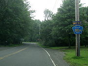
Route 80

County Route 80 is the longest west–east county route in Rockland County at 10.4 miles (16.7 km) miles, and ranks third overall to CR 33
County Route 33 (Rockland County, New York)
County Route 33 is a south–north county route in the central part of Rockland County, New York. Prior to 1970, portions of CR 33 were designated as the old route of New York State Route 304. Today, CR 33 serves as an alternative route for NY 304 from Pearl River to New City...
(13.3 miles) and CR 23 (11.0 miles). CR 80 runs through Montebello, Wesley Hills, New Hempstead, New City, and Congers.
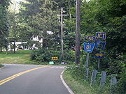
Route 80A

Rockland County, New York
Rockland County is a suburban county 15 miles to the northwest of Manhattan and part of the New York City Metropolitan Area, in the U.S. state of New York. It is the southernmost county in New York west of the Hudson River, and the smallest county in New York outside of New York City. The...
.
Route 80A begins at CR 80, and ends at CR 85. CR 80A is located exclusively in Montebello. CR 80A is a spur that allows drivers from CR 80 or CR 85 to switch roads without driving directly to the CR 80/CR 85 intersection. The western end of the route is at the driveway of Yeshivas Ohr Reuven, a private Jewish high school.
Route 81

Rockland County, New York
Rockland County is a suburban county 15 miles to the northwest of Manhattan and part of the New York City Metropolitan Area, in the U.S. state of New York. It is the southernmost county in New York west of the Hudson River, and the smallest county in New York outside of New York City. The...
.
Route 81 begins close to the New Jersey border at CR 73 in Monsey, and ends at US 202, near Harriman State Park, in Wesley Hills. CR 81 runs through Monsey, Airmont, Viola, and Wesley Hills. Instead of making a straight path toward a southern terminus at the New Jersey border, CR 81 curves east ending at CR 73. This is to keep CR 81 from being routed into Ascension Cemetery, which is located just north of the New York/New Jersey border along CR 73. CR 81 is routed through mostly residential areas except when it intersects NY 59, and passes Rockland Community College
Rockland Community College
Rockland Community College is a two-year college in the State University of New York system, located in hamlet of Viola within the Village of Suffern from the Town of Ramapo in Rockland County, New York. The college began in 1959 in the former county almshouse. The college offers 48 programs and...
. CR 81 briefly becomes a four-lane road when it passes the college before its intersection with CR 74. After CR 81 passes the college, it goes back to being routed through residential areas. CR 81 runs parallel to CR 85 throughout most of its route. Both are about 6 miles (9.7 km) in length, with CR 81 being the longest Rockland County Route that is entirely located west of the Palisades Interstate Parkway
Palisades Interstate Parkway
The Palisades Interstate Parkway is a long limited-access highway in the U.S. states of New Jersey and New York. The parkway is a major commuter route into New York City from Rockland and Orange counties in New York and Bergen County in New Jersey...
.
Route 83


Rockland County, New York
Rockland County is a suburban county 15 miles to the northwest of Manhattan and part of the New York City Metropolitan Area, in the U.S. state of New York. It is the southernmost county in New York west of the Hudson River, and the smallest county in New York outside of New York City. The...
.
Route 83 begins at CR 98, and ends at CR 106. CR 83 runs exclusively through rural Stony Point. CR 83 begins and ends near different entrances to Harriman State Park along Gate Hill Road. CR 83 runs parallel to the Palisades Interstate Parkway
Palisades Interstate Parkway
The Palisades Interstate Parkway is a long limited-access highway in the U.S. states of New Jersey and New York. The parkway is a major commuter route into New York City from Rockland and Orange counties in New York and Bergen County in New Jersey...
between Exits 14 and 15. CR 83's southern terminus is close to CR 75's northern terminus at Call Hollow Road.
Route 84


Rockland County, New York
Rockland County is a suburban county 15 miles to the northwest of Manhattan and part of the New York City Metropolitan Area, in the U.S. state of New York. It is the southernmost county in New York west of the Hudson River, and the smallest county in New York outside of New York City. The...
.
Route 84 beings at US 202, and ends at NY 306. CR 84 runs exclusively in Wesley Hills. CR 84 is an alternate route to CR 80
County Route 80 (Rockland County, New York)
County Route 80 is a west–east county route in the central part of Rockland County, New York. CR 80 serves as an alternative route for NY 59 and the New York State Thruway . In fact, CR 80 is the only route besides those two major routes that runs completely from the...
, as it runs parallel with it for its entire run. CR 84's western terminus is near Harriman State Park just beyond US 202. CR 84's western terminus is also the northern terminus of CR 85. CR 84's eastern terminus is less than a mile from CR 86 off of NY 306. CR 84 mainly runs through residential areas, and provides a link to Willow Tree Town Park in Wesley Hills.
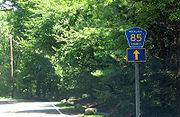
Route 85

Rockland County, New York
Rockland County is a suburban county 15 miles to the northwest of Manhattan and part of the New York City Metropolitan Area, in the U.S. state of New York. It is the southernmost county in New York west of the Hudson River, and the smallest county in New York outside of New York City. The...
.
Route 85 begins at the New Jersey border in Airmont and Upper Saddle River, New Jersey
Upper Saddle River, New Jersey
Upper Saddle River is an affluent borough in Bergen County, New Jersey, United States. As of the 2010 United States Census, the borough population was 8,208. It is not to be confused with the neighboring borough of Saddle River.-History:...
, and ends at US 202 in Wesley Hills, near Harriman State Park. CR 85 runs through Airmont, Montebello, and Wesley Hills. CR 85 runs parallel with CR 81 for its entire run. CR 85 passes Spook Rock Golf Course and a couple county parks and pools during its route. CR 85 ends at the New York/New Jersey border, but Cherry Lane continues for another half mile before ending in Upper Saddle River. At its northern terminus, CR 85 shares a terminus with CR 84 at US 202. On US 202, there are no CR 85 junction signs, only CR 84, which begins at the same location as CR 85.
Route 86

Rockland County, New York
Rockland County is a suburban county 15 miles to the northwest of Manhattan and part of the New York City Metropolitan Area, in the U.S. state of New York. It is the southernmost county in New York west of the Hudson River, and the smallest county in New York outside of New York City. The...
.
Route 86 begins at NY 306 in Pomona, and ends at NY 45 in New Hempstead. CR 86 runs exclusively though Pomona, although comes close to Wesley Hills
Wesley Hills, New York
Wesley Hills is a village in the Town of Ramapo, Rockland County, New York, United States located north of Viola; east of Harriman State Park; south of Pomona and west of New Hempstead...
at its western terminus, and close to New Hempstead
New Hempstead, New York
New Hempstead, formally known as Kakiat , is a village in the Town of Ramapo, Rockland County, New York, United States located north of New Square; east of Wesley Hills; south of Pomona and west of New City...
at its eastern terminus. CR 86's western terminus is about a quarter-mile north of CR 84's eastern terminus along NY 306. CR 86's eastern terminus is about a tenth of a mile south of NY 45's intersection with the Palisades Interstate Parkway
Palisades Interstate Parkway
The Palisades Interstate Parkway is a long limited-access highway in the U.S. states of New Jersey and New York. The parkway is a major commuter route into New York City from Rockland and Orange counties in New York and Bergen County in New Jersey...
(Exit 12). CR 86 is an alternate route to (CR 80
County Route 80 (Rockland County, New York)
County Route 80 is a west–east county route in the central part of Rockland County, New York. CR 80 serves as an alternative route for NY 59 and the New York State Thruway . In fact, CR 80 is the only route besides those two major routes that runs completely from the...
), as it runs parallel with it for its entire run. CR 86 runs along the south border of Minisceongo Golf Club and Mount Ivy County Park for a brief period during its run. CR 86 also passes Pomona Middle School along its route. CR86 also provides access to Provident Bank Park
Provident Bank Park
Provident Bank Park is a stadium in Ramapo, New York. It is primarily used for baseball and is the home field of the Rockland Boulders Canadian-American Association of Professional Baseball independent minor league baseball team. It was opened on June 16, 2011, a 3-1 win against the Brockton...
, home of the Rockland Boulders
Rockland Boulders
The Rockland Boulders is an American professional baseball team based in Pomona, New York in the County of Rockland. It is a member of the Canadian American Association of Professional Baseball, also known as the Can-Am League...
of the Can-Am League, near the end of its route.
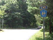
Route 89

Rockland County, New York
Rockland County is a suburban county 15 miles to the northwest of Manhattan and part of the New York City Metropolitan Area, in the U.S. state of New York. It is the southernmost county in New York west of the Hudson River, and the smallest county in New York outside of New York City. The...
.
Route 89 begins at the New Jersey border in Airmont and Mahwah, New Jersey
Mahwah, New Jersey
Mahwah is a township in Bergen County, New Jersey, United States. As of the 2010 United States Census, the township population was 25,890. The name Mahwah is derived from the Lenni Lenape word "mawewi" which means "Meeting Place" or "Place Where Paths Meet".The area that is now Mahwah was...
, and ends just 0.2 mile (0.321868 km) north of the New York State Thruway
New York State Thruway
The New York State Thruway is a system of limited-access highways located within the state of New York in the United States. The system, known officially as the Governor Thomas E. Dewey Thruway for former New York Governor Thomas E. Dewey, is operated by the New York State Thruway Authority and...
. CR 89 runs exclusively in Airmont. CR 89 begins after the New Jersey border in residential areas. However, the last half-mile CR 89 intersects NY 59 and the New York State Thruway
New York State Thruway
The New York State Thruway is a system of limited-access highways located within the state of New York in the United States. The system, known officially as the Governor Thomas E. Dewey Thruway for former New York Governor Thomas E. Dewey, is operated by the New York State Thruway Authority and...
(I-87/I-287). CR 89 is the only Rockland County Route that has a full intersection with the New York State Thruway (exit 14B). CR 89 provides links to Airmont Lutheran Cemetery, Airmont Town Park, and Fred Rello Fields Town Park. South of CR 89's southern terminus at the New York/NJ border, Airmont Avenue continues to its eventual end at NJ 17.
Route 90

Rockland County, New York
Rockland County is a suburban county 15 miles to the northwest of Manhattan and part of the New York City Metropolitan Area, in the U.S. state of New York. It is the southernmost county in New York west of the Hudson River, and the smallest county in New York outside of New York City. The...
.
Route 90 begins at CR 29 in New City, and ends at US 9W just into the village of Haverstraw. CR 90 runs through the northern parts of New City, and crosses the Haverstraw line just before its eastern terminus. CR 90 runs along the southern border of Hi-Tor State Park. CR 29 marks the western terminus of CR 90, but the road continues as South Mountain Road which continues all the way to NY 45
New York State Route 45
New York State Route 45 is a north–south state highway in central Rockland County, New York, United States. It spans from the village of Chestnut Ridge at the New Jersey – New York border, where it becomes County Route 73 in Bergen County, New Jersey, to U.S. Route 202 in...
in Pomona
Pomona, New York
Pomona is a village partly in the Town of Ramapo and partly in the Town of Haverstraw in Rockland County, New York, United States, located north of New Hempstead, east of Harriman State Park, north of Monsey and west of Mount Ivy. According to the 2010 Census, the population was 3,103, a 13 percent...
. CR 90's western terminus is also CR 29's northern terminus. At CR 90's eastern terminus at US 9W, the driver has a beautiful view of the Hudson River
Hudson River
The Hudson is a river that flows from north to south through eastern New York. The highest official source is at Lake Tear of the Clouds, on the slopes of Mount Marcy in the Adirondack Mountains. The river itself officially begins in Henderson Lake in Newcomb, New York...
and Westchester County
Westchester County, New York
Westchester County is a county located in the U.S. state of New York. Westchester covers an area of and has a population of 949,113 according to the 2010 Census, residing in 45 municipalities...
.
CR 90 is part of the original routing of NY 304
New York State Route 304
New York State Route 304 is a New York State Route that is entirely located in Central Rockland County. NY 304 begins at the New Jersey-New York border in Pearl River, New York, and ends at US 9W. Though it crosses both the New York State Thruway and the Palisades Interstate...
.
Route 93


Rockland County, New York
Rockland County is a suburban county 15 miles to the northwest of Manhattan and part of the New York City Metropolitan Area, in the U.S. state of New York. It is the southernmost county in New York west of the Hudson River, and the smallest county in New York outside of New York City. The...
.
Route 93 begins at NY 59 in Suffern, and ends at CR 64 in Montebello. CR 93 runs in Suffern and Montebello. CR 93 crosses the New York State Thruway
New York State Thruway
The New York State Thruway is a system of limited-access highways located within the state of New York in the United States. The system, known officially as the Governor Thomas E. Dewey Thruway for former New York Governor Thomas E. Dewey, is operated by the New York State Thruway Authority and...
(I-287), but does not intersect the highway. CR 93's southern terminus is near Good Samaritan Hospital
Good Samaritan Hospital (Suffern)
Good Samaritan Hospital is a non-profit, 370-bed hospital providing services to residents of Rockland County and southern Orange County in New York and northern Bergen County, New Jersey. The hospital also serves these communities as an Area Level II Trauma Center. Good Samaritan Hospital is a...
, on NY 59, in Suffern. CR 93's northern terminus is at Suffern Middle School, and it shares a terminus with CR 64 at this location. CR 93 is mainly a cut-through route from downtown Suffern to more residential areas in Montebello. The route provides a link to a Novartis
Novartis
Novartis International AG is a multinational pharmaceutical company based in Basel, Switzerland, ranking number three in sales among the world-wide industry...
pharmaceutical plant.
Route 94


Rockland County, New York
Rockland County is a suburban county 15 miles to the northwest of Manhattan and part of the New York City Metropolitan Area, in the U.S. state of New York. It is the southernmost county in New York west of the Hudson River, and the smallest county in New York outside of New York City. The...
.
Route 94 begins at CR 98 in Thiells, and ends at CR 108 in West Haverstraw. CR 94 runs through Thiells, Garnerville, and West Haverstraw. CR 94 has a key junction with US 9W/US 202 in West Haverstraw. CR 94 begins just east of CR 98's intersection with the Palisades Interstate Parkway
Palisades Interstate Parkway
The Palisades Interstate Parkway is a long limited-access highway in the U.S. states of New Jersey and New York. The parkway is a major commuter route into New York City from Rockland and Orange counties in New York and Bergen County in New Jersey...
(exit 14) and Harriman State Park. CR 94 provides access to Patriot Hills Golf Course and Phillip J Rotella Golf Course in Thiells. CR 94 formally ended at CR 33 in Garnerville, but recently was extended beyond US 9W/US 202 down toward the Hudson River
Hudson River
The Hudson is a river that flows from north to south through eastern New York. The highest official source is at Lake Tear of the Clouds, on the slopes of Mount Marcy in the Adirondack Mountains. The river itself officially begins in Henderson Lake in Newcomb, New York...
and Haverstraw Bay County Park. CR 94's western terminus is just across the street from the Stony Point village line.
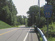
Route 95

Rockland County, New York
Rockland County is a suburban county 15 miles to the northwest of Manhattan and part of the New York City Metropolitan Area, in the U.S. state of New York. It is the southernmost county in New York west of the Hudson River, and the smallest county in New York outside of New York City. The...
.
Route 95 begins at NY 59 in Hillburn, and ends at a dead end in Sloatsburg. CR 95 goes through Hillburn and Sloatsburg. CR 95 travels along the southwestern border of Harriman State Park. CR 95 parallels NY 59 for the first part of the route, and once it passes Flat Rock Park it goes off on its own. CR 95 then passes Torne Valley Sports Complex during its course. CR 95's final stages is home to several of Rockland County's waste management areas. CR 95's southern terminus is close to US 202 in Suffern, and NY 59's western terminus at NY 17
New York State Route 17
New York State Route 17 is a state highway that extends for through the Southern Tier and Downstate regions of New York in the United States...
which is at Exit 15A of the New York State Thruway
New York State Thruway
The New York State Thruway is a system of limited-access highways located within the state of New York in the United States. The system, known officially as the Governor Thomas E. Dewey Thruway for former New York Governor Thomas E. Dewey, is operated by the New York State Thruway Authority and...
(I-87) in Hillburn.
Route 97

Rockland County, New York
Rockland County is a suburban county 15 miles to the northwest of Manhattan and part of the New York City Metropolitan Area, in the U.S. state of New York. It is the southernmost county in New York west of the Hudson River, and the smallest county in New York outside of New York City. The...
.
Route 97 begins at the Sloatsburg village line, and ends at a dead end in Harriman State Park. CR 97 does not enter the village limits of any town in Rockland County, therefore it is designated in the Town of Ramapo. After CR 97's southern terminus, the road continues as Johnstown Road, which continues for another half-mile before ending at Seven Lakes Drive
Seven Lakes Drive
Seven Lakes Drive is a 17.91 mile long parkway in the U.S. state of New York. The southern terminus of the route is at New York State Route 17 in Sloatsburg. The northern terminus is at U.S. Route 9W and U.S. Route 202 a mile south of Fort Montgomery in Bear Mountain State Park...
. CR 97 is the most hidden Rockland County Route as there are no indictations that it exists. Johnstown Road is a small, narrow road that appears to be nothing more than a dead end. However, it quickly changes to a two-lane road, and CR 97 begins. CR 97 runs along the southern border of Dater Mountain Nature County Park for most of its route. At the northern terminus of CR 97, there are two hiking trails that lead into Harriman State Park. CR 97 does not intersect any major routes along its run.
Stony Brook Drive, now Johnsontown Road, begins at Seven Lakes Drive, just after the Thruway underpass. It was once a main park drive that went all the way to Lake Sebago and Little Long Pond. From the 1920s to 1962, maps recognized this street as Stony Brook Drive. The name, after 1962, was changed to Johnsontown Road, named after the old village. The road is now just a 1.6 miles (2.6 km) road that ends at a cul-de-sac.
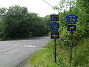
Route 98

Rockland County, New York
Rockland County is a suburban county 15 miles to the northwest of Manhattan and part of the New York City Metropolitan Area, in the U.S. state of New York. It is the southernmost county in New York west of the Hudson River, and the smallest county in New York outside of New York City. The...
.
Route 98 begins at CR 106, near Harriman State Park, and ends at US 9W/US 202. CR 98 runs through the Rockland County town of Stony Point, and as well the village limits of Thiells and Stony Point. CR 98 has a junction with the Palisades Interstate Parkway
Palisades Interstate Parkway
The Palisades Interstate Parkway is a long limited-access highway in the U.S. states of New Jersey and New York. The parkway is a major commuter route into New York City from Rockland and Orange counties in New York and Bergen County in New Jersey...
(at Exit 14). CR 98 is an alternate route for CR 106 as it has a very similar path heading into Stony Point. CR 98's western terminus is very close to the CR 106 entrance into Harriman State Park, near Lake Welch, and even borders a piece of the state park that extends out from the rest of the park to the Palisades Interstate Parkway. CR 98 passes Patriot Hill Golf Course and Stony Point Town Park along its route.
CR 98 has one suffixed route, CR 98A. It is located in the town of Stony Point. (see below)
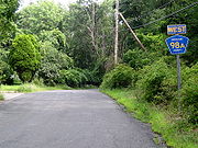
Route 98A

Rockland County, New York
Rockland County is a suburban county 15 miles to the northwest of Manhattan and part of the New York City Metropolitan Area, in the U.S. state of New York. It is the southernmost county in New York west of the Hudson River, and the smallest county in New York outside of New York City. The...
.
Route 98A begins at CR 106, and ends at CR 98. CR 98A is located in Stony Point. CR 98A allows drivers to cut from CR 98 to CR 106 or vice versa without going to their intersection. CR 98A is located just before CR 98's western terminus at CR 106 near Harriman State Park. CR 98A is not all that far from Lake Welch and Seven Lakes Drive
Seven Lakes Drive
Seven Lakes Drive is a 17.91 mile long parkway in the U.S. state of New York. The southern terminus of the route is at New York State Route 17 in Sloatsburg. The northern terminus is at U.S. Route 9W and U.S. Route 202 a mile south of Fort Montgomery in Bear Mountain State Park...
.
Route 100

Rockland County, New York
Rockland County is a suburban county 15 miles to the northwest of Manhattan and part of the New York City Metropolitan Area, in the U.S. state of New York. It is the southernmost county in New York west of the Hudson River, and the smallest county in New York outside of New York City. The...
.
Route 100 begins at CR 47, and ends at US 9W/US 202. CR 100 runs exclusively in Stony Point. CR 100 runs parallel to CR 106 and CR 98 for its entire run. CR 100 runs mainly through residential neighborhoods, but its eastern terminus is at US 9W/US 202 in downtown Stony Point. CR 100 provides a link for Stony Point Town Park in western Stony Point. To the east of CR 100's eastern terminus is Cedar Pond Brook, which filters into the Hudson River
Hudson River
The Hudson is a river that flows from north to south through eastern New York. The highest official source is at Lake Tear of the Clouds, on the slopes of Mount Marcy in the Adirondack Mountains. The river itself officially begins in Henderson Lake in Newcomb, New York...
.
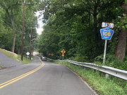
Route 106

Route 108

Rockland County, New York
Rockland County is a suburban county 15 miles to the northwest of Manhattan and part of the New York City Metropolitan Area, in the U.S. state of New York. It is the southernmost county in New York west of the Hudson River, and the smallest county in New York outside of New York City. The...
.
Route 108 begins at CR 106 in Stony Point, and ends at CR 94 in West Haverstraw. CR 108 runs through Stony Point and West Haverstraw. CR 108 runs parallel to CR 106 until its junction with US 9W/US 202, but as it hits the Hudson River
Hudson River
The Hudson is a river that flows from north to south through eastern New York. The highest official source is at Lake Tear of the Clouds, on the slopes of Mount Marcy in the Adirondack Mountains. The river itself officially begins in Henderson Lake in Newcomb, New York...
it turns south and runs along the shore. CR 108 actually heads west for less than a quarter of a mile before ending at CR 94. In fact, due to the bizarre routing, CR 108's eastern terminus is CR 94's eastern terminus as well. CR 108 passes the Stony Point Marina and Haverstraw Bay County Park along the Hudson River. From the shore, drivers can see Indian Point Energy Center
Indian Point Energy Center
Indian Point Energy Center is a three-unit nuclear power plant station located in Buchanan, New York just south of Peekskill. It sits on the east bank of the Hudson River, 38 miles north of New York City...
, and on clear days, and from certain elevations, the Bear Mountain Bridge
Bear Mountain Bridge
The Bear Mountain Bridge is a toll suspension bridge in New York State, carrying U.S. Highways 202 and 6 across the Hudson River between Rockland and Westchester counties...
.
CR 108 is part of the original routing of NY 210
New York State Route 210
New York State Route 210 is a state highway in Orange County, New York, in the United States. It runs north from the New Jersey state line—where it continues south as Passaic County Route 511 —along the west shore of Greenwood Lake to the eponymous village of Greenwood Lake, where it...
.
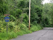
Route 109

Rockland County, New York
Rockland County is a suburban county 15 miles to the northwest of Manhattan and part of the New York City Metropolitan Area, in the U.S. state of New York. It is the southernmost county in New York west of the Hudson River, and the smallest county in New York outside of New York City. The...
.
Route 109 begins at a dead end near Haverstraw Bay County Park, and ends at CR 108. CR 109 runs exclusively in West Haverstraw. The only reassurance signs along the route face the wrong way, and some maps, including Google Maps
Google Maps
Google Maps is a web mapping service application and technology provided by Google, free , that powers many map-based services, including the Google Maps website, Google Ride Finder, Google Transit, and maps embedded on third-party websites via the Google Maps API...
, actually show CR 109 heading into the park. This should all be straightened out when construction in Haverstraw Bay County Park is completed.
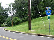
Route 110

Rockland County, New York
Rockland County is a suburban county 15 miles to the northwest of Manhattan and part of the New York City Metropolitan Area, in the U.S. state of New York. It is the southernmost county in New York west of the Hudson River, and the smallest county in New York outside of New York City. The...
. It is also multiplexed with part of New York State Bicycle Route 9.
Route 110 begins at US 9W/US 202, and ends at CR 108. CR 110 runs exclusively in Stony Point. Along with CR 108, CR 110 runs along the Hudson River
Hudson River
The Hudson is a river that flows from north to south through eastern New York. The highest official source is at Lake Tear of the Clouds, on the slopes of Mount Marcy in the Adirondack Mountains. The river itself officially begins in Henderson Lake in Newcomb, New York...
for an extended length of time. CR 110 is Tompkins Avenue and the northern portion of Beach Road that runs along the Hudson River, and CR 108 provides the southern portion. CR 110 provides the driver with an excellent view of the Hudson River, Westchester County
Westchester County, New York
Westchester County is a county located in the U.S. state of New York. Westchester covers an area of and has a population of 949,113 according to the 2010 Census, residing in 45 municipalities...
, and Indian Point Energy Center
Indian Point Energy Center
Indian Point Energy Center is a three-unit nuclear power plant station located in Buchanan, New York just south of Peekskill. It sits on the east bank of the Hudson River, 38 miles north of New York City...
. CR 110 comes close to the Stony Point Marina, which is located along CR 108. A little farther north when CR 110 turns west is the historic Battle of Stony Point
Battle of Stony Point
The Battle of Stony Point was a battle of the American Revolutionary War fought on the night of July 15–16, 1779. A select force of Continental Army infantry made a coordinated surprise night attack and stormed a fortified position of the British Army on the Hudson River south of West Point, New...
battlefield, which was fought at during the Revolutionary War
American Revolutionary War
The American Revolutionary War , the American War of Independence, or simply the Revolutionary War, began as a war between the Kingdom of Great Britain and thirteen British colonies in North America, and ended in a global war between several European great powers.The war was the result of the...
.
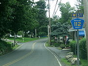
Route 112
Rockland County, New York
Rockland County is a suburban county 15 miles to the northwest of Manhattan and part of the New York City Metropolitan Area, in the U.S. state of New York. It is the southernmost county in New York west of the Hudson River, and the smallest county in New York outside of New York City. The...
.
Route 112 begins at CR 108, and ends at US 9W/US 202. CR 112 runs exclusively through Stony Point. CR 112 runs through mainly residential areas. CR 112's western terminus is less than a tenth of a mile from CR 65's southern terminus. In fact, CR 112, CR 65, and CR 108 all end within a quarter-mile from each other. CR 112 begins in a northern direction, but near Lake Boyce it turns due east toward its eastern terminus at US 9W/US 202. CR 112's eastern terminus comes very close to CR 53's southern terminus.
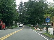
Route 118

Rockland County, New York
Rockland County is a suburban county 15 miles to the northwest of Manhattan and part of the New York City Metropolitan Area, in the U.S. state of New York. It is the southernmost county in New York west of the Hudson River, and the smallest county in New York outside of New York City. The...
.
Route 118 begins at CR 65 and former CR 69 in Bulsontown, and ends at US 9W/US 202, in Tomkins Cove, near the Hudson River
Hudson River
The Hudson is a river that flows from north to south through eastern New York. The highest official source is at Lake Tear of the Clouds, on the slopes of Mount Marcy in the Adirondack Mountains. The river itself officially begins in Henderson Lake in Newcomb, New York...
. CR 118 runs through Bulsontown and Tomkins Cove. CR 118's western terminus is also the northern terminus of CR 65. In fact, this location used to be a tri-terminus with CR 118, CR 65, and former CR 69. CR 118 runs along the southern border of Bear Mountain State Park
Bear Mountain State Park
Bear Mountain State Park is located on the west side of the Hudson River in Orange and Rockland counties of New York. The park offers biking, hiking, boating, picnicking, swimming, cross-country skiing, cross-country running, sledding and ice skating...
, and passes Bullova Lake and is a link to Tomkins Lake.
CR 118 also passes a disjointed piece of Harriman State Park along its route. In fact, this piece of Harriman State Park is a couple of miles away from the main part of the state park. CR 118 is the highest labeled Rockland County route in any direction, and is the northern most Rockland County route.
Route 118A
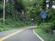
Tomkins Cove, New York
Tomkins Cove is an unincorporated hamlet in the Town of Stony Point Rockland County, New York, United States located north of Stony Point; east of Harriman State Park; south of Doodletown and west of the Hudson River. It is located north-northwest of New York City. The population is approximately...
. CR 118A is a spur that allows drivers from US 9W/US 202 or CR 118 from having to travel to their intersection. While CR 118A is north of CR 118 it is not the northernmost Rockland County Route because CR 118 travels further north during its route.
CR 118A provides the driver a great view of the Hudson River
Hudson River
The Hudson is a river that flows from north to south through eastern New York. The highest official source is at Lake Tear of the Clouds, on the slopes of Mount Marcy in the Adirondack Mountains. The river itself officially begins in Henderson Lake in Newcomb, New York...
and Indian Point Energy Center
Indian Point Energy Center
Indian Point Energy Center is a three-unit nuclear power plant station located in Buchanan, New York just south of Peekskill. It sits on the east bank of the Hudson River, 38 miles north of New York City...
across the river in Westchester County
Westchester County, New York
Westchester County is a county located in the U.S. state of New York. Westchester covers an area of and has a population of 949,113 according to the 2010 Census, residing in 45 municipalities...
. CR 118A leads into West Shore Road beyond its eastern terminus at US 9W/US 202. West Shore Road runs right along the Hudson River before ending back at US 9W/US 202 a mile or so north. The New York State Department of Transportation
New York State Department of Transportation
The New York State Department of Transportation is responsible for the development and operation of highways, railroads, mass transit systems, ports, waterways and aviation facilities in the U.S...
's traffic counts document actually lists CR 118A as Mott Farm Road, which is parent route CR 118's street name.
County Route 118A begins at an intersection with County Route 118 in Tomkins Cove. The route heads northward along Gays Hill Road, passing a short patch of woodlands. A short distance later, Route 118A comes upon its only intersection, a local driveway. The route makes a short bend, passing another patch of trees in both directions and terminating at an intersection with U.S. Route 9W and U.S. Route 202 in Tomkins Cove.
See also
- List of county routes in Rockland County, New York
- List of county routes in Rockland County, New York (1–38)
- List of county routes in Rockland County, New York (41–75)
- County routes in New YorkCounty Routes in New YorkIn the U.S. state of New York, county routes exist in all 62 counties except those in the five boroughs of New York City. Most are maintained locally by county highway departments...