
.gif)
County Route 80 (Rockland County, New York)
Encyclopedia
County Route 80 is a 10.4 miles (16.7 km) west–east county route in the central part of Rockland County, New York
. CR 80 serves as an alternative route for NY 59
and the New York State Thruway
(I-87/I-287). In fact, CR 80 is the only route besides those two major routes that runs completely from the western end of the county to the eastern end. CR 80 is the longest west–east county route in Rockland County, and the third longest route to CR 33
and CR 106
. CR 80 intersects several major south–north roads within the county, and intersects the Palisades Interstate Parkway
at Exit 11 in New Hempstead. CR 80 has one present suffixed route, CR 80A in Montebello. Until recently, the highway had two with CR 80B located in New City.
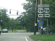
CR 80 runs through Montebello, Wesley Hills, New Hempstead, New City, and Congers. CR 80 is an alternate route to NY 59 and I-87/I-287 in Rockland County. The road crosses Lake DeForest before ending at US 9W in Congers. CR 80's eastern terminus is across the street from one of the two entrances to Rockland Lake State Park
via US 9W. Despite CR 80 end shields existing at US 9W, Rockland County maps show CR 80 crossing US 9W and encompassing Rockland Lake Road in its entirety. The road circles through Rockland Lake State Park, and ends back at US 9W about a mile and a half south of CR 80's signed eastern terminus.
 County Route 80 begins at US Route 202 in Montebello across the street from Kakiat County Park, which is an extension of Harriman State Park. From there, the highway proceeds east along Grandview Avenue through residential areas of Montebello. Here CR 80 intersects its child-route, CR 80A and CR 85. The highway continues to travel east along Grandview Avenue into the village of Wesley Hills. CR 80 intersects two major south–north routes in western Rockland, CR 81 and NY 306
. At its intersection with CR 81, turning onto CR 81 reaches Rockland Community College
. At NY 306, one can turn south onto NY 306 and reach Church of the West Hampstead Cemetery, which is one of the largest cemeteries in Rockland County. From here, CR 80 proceeds east into New Hempstead.
In New Hempstead, the highway briefly turns north at Union Road and levels back east when it intersects CR 67. CR 80 then intersects CR 51 before reaching one of its busiest segments in western New Hempstead, with the intersections with NY 45
and the Palisades Interstate Parkway
(at Exit 11) within a half mile of each other. Exit 11 is an alternative exit for New City residents who wish not to exit at Exit 10.
 CR 80 enters New City shortly after its intersection with the PIP, and quickly intersects the northern terminus of CR 35A. the highway then intersects CR 33
at Little Tor Road which marks the intersection of the two longest Rockland County Routes in their specific direction. CR 80 then proceeds east into downtown New City. At its intersection with CR 29, CR 80 quickly turns south along Main Street for one-tenth of a mile before heading east again along Congers Road. Here, CR 80 intersects NY 304
before heading north for a bit toward its crossing of Lake DeForest. Before crossing the lake and heading into Congers, The highway intersects CR 23, which is a major residential south–north Rockland County route totaling 11 miles (18 km) in length.
After crossing Lake DeForest, CR 80 proceeds east into downtown Congers. Here it intersects CR 13 and NY 303
. Around NY 303, the highway skims the northern part of Congers Lake. After NY 303, CR 80 proceeds toward its eastern terminus at US 9W across the street from Rockland Lake State Park
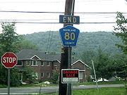
. A CR 80 end shield exists at this location, but some maps show the highway continuing east into Rockland Lake, where it circles the lake before ending back at US 9W in a western direction.
 CR 80 was the northern terminus of the proposed Spring Valley Bypass, which was to extend from NY 59
in Monsey
. The Spring Valley Bypass was proposed in 1960, but has not been built to this date. In July 2006, An amount of $16,500 was given to Rockland County to reconstruct the New Hempstead Road segment of CR 80 from the Palisades Interstate Parkway to NY 304
. In January 2006, the University at Albany came up with the proposal to make CR 80 a safer route to walk on. Proposed initiatives include sidewalks along the whole distance of the county-maintained road, new bike lanes and bicycle storage locations, the latter at sections.
Rockland County, New York
Rockland County is a suburban county 15 miles to the northwest of Manhattan and part of the New York City Metropolitan Area, in the U.S. state of New York. It is the southernmost county in New York west of the Hudson River, and the smallest county in New York outside of New York City. The...
. CR 80 serves as an alternative route for NY 59
New York State Route 59
New York State Route 59 is an east–west state highway in southern Rockland County, New York, in the United States. The route extends for from NY 17 in Hillburn to U.S. Route 9W in Nyack. In Suffern, it has a concurrency with US 202 for . NY 59 runs parallel to the New...
and the New York State Thruway
New York State Thruway
The New York State Thruway is a system of limited-access highways located within the state of New York in the United States. The system, known officially as the Governor Thomas E. Dewey Thruway for former New York Governor Thomas E. Dewey, is operated by the New York State Thruway Authority and...
(I-87/I-287). In fact, CR 80 is the only route besides those two major routes that runs completely from the western end of the county to the eastern end. CR 80 is the longest west–east county route in Rockland County, and the third longest route to CR 33
County Route 33 (Rockland County, New York)
County Route 33 is a south–north county route in the central part of Rockland County, New York. Prior to 1970, portions of CR 33 were designated as the old route of New York State Route 304. Today, CR 33 serves as an alternative route for NY 304 from Pearl River to New City...
and CR 106
County Route 106 (Rockland County, New York)
County Route 106 is the continuation of Orange County Route 106 in Rockland County, New York. The route is long and heads east–west through Harriman State Park. The route originated as New York State Route 210 and as County Highway 416 back in the 1920s and 1930s...
. CR 80 intersects several major south–north roads within the county, and intersects the Palisades Interstate Parkway
Palisades Interstate Parkway
The Palisades Interstate Parkway is a long limited-access highway in the U.S. states of New Jersey and New York. The parkway is a major commuter route into New York City from Rockland and Orange counties in New York and Bergen County in New Jersey...
at Exit 11 in New Hempstead. CR 80 has one present suffixed route, CR 80A in Montebello. Until recently, the highway had two with CR 80B located in New City.
CR 80 runs through Montebello, Wesley Hills, New Hempstead, New City, and Congers. CR 80 is an alternate route to NY 59 and I-87/I-287 in Rockland County. The road crosses Lake DeForest before ending at US 9W in Congers. CR 80's eastern terminus is across the street from one of the two entrances to Rockland Lake State Park
Rockland Lake State Park
Rockland Lake State Park is located on a ridge of Hook Mountain above the west bank of the Hudson River, in the hamlet of Congers, which is in the eastern part of the Town of Clarkstown in Rockland County, New York. The park sits between the west bank of the Hudson River and Route 9W...
via US 9W. Despite CR 80 end shields existing at US 9W, Rockland County maps show CR 80 crossing US 9W and encompassing Rockland Lake Road in its entirety. The road circles through Rockland Lake State Park, and ends back at US 9W about a mile and a half south of CR 80's signed eastern terminus.
Route description
New York State Route 306
New York State Route 306 is a north–south state highway in western Rockland County, New York in the United States. NY 306 runs from NY 59 in the hamlet of Monsey to U.S. Route 202 in Ladentown, on the western boundary of the village of Pomona...
. At its intersection with CR 81, turning onto CR 81 reaches Rockland Community College
Rockland Community College
Rockland Community College is a two-year college in the State University of New York system, located in hamlet of Viola within the Village of Suffern from the Town of Ramapo in Rockland County, New York. The college began in 1959 in the former county almshouse. The college offers 48 programs and...
. At NY 306, one can turn south onto NY 306 and reach Church of the West Hampstead Cemetery, which is one of the largest cemeteries in Rockland County. From here, CR 80 proceeds east into New Hempstead.
In New Hempstead, the highway briefly turns north at Union Road and levels back east when it intersects CR 67. CR 80 then intersects CR 51 before reaching one of its busiest segments in western New Hempstead, with the intersections with NY 45
New York State Route 45
New York State Route 45 is a north–south state highway in central Rockland County, New York, United States. It spans from the village of Chestnut Ridge at the New Jersey – New York border, where it becomes County Route 73 in Bergen County, New Jersey, to U.S. Route 202 in...
and the Palisades Interstate Parkway
Palisades Interstate Parkway
The Palisades Interstate Parkway is a long limited-access highway in the U.S. states of New Jersey and New York. The parkway is a major commuter route into New York City from Rockland and Orange counties in New York and Bergen County in New Jersey...
(at Exit 11) within a half mile of each other. Exit 11 is an alternative exit for New City residents who wish not to exit at Exit 10.
County Route 33 (Rockland County, New York)
County Route 33 is a south–north county route in the central part of Rockland County, New York. Prior to 1970, portions of CR 33 were designated as the old route of New York State Route 304. Today, CR 33 serves as an alternative route for NY 304 from Pearl River to New City...
at Little Tor Road which marks the intersection of the two longest Rockland County Routes in their specific direction. CR 80 then proceeds east into downtown New City. At its intersection with CR 29, CR 80 quickly turns south along Main Street for one-tenth of a mile before heading east again along Congers Road. Here, CR 80 intersects NY 304
New York State Route 304
New York State Route 304 is a New York State Route that is entirely located in Central Rockland County. NY 304 begins at the New Jersey-New York border in Pearl River, New York, and ends at US 9W. Though it crosses both the New York State Thruway and the Palisades Interstate...
before heading north for a bit toward its crossing of Lake DeForest. Before crossing the lake and heading into Congers, The highway intersects CR 23, which is a major residential south–north Rockland County route totaling 11 miles (18 km) in length.
After crossing Lake DeForest, CR 80 proceeds east into downtown Congers. Here it intersects CR 13 and NY 303
New York State Route 303
New York State Route 303 is a north–south state highway in eastern Rockland County, New York, in the United States. It begins at the New Jersey state line in the hamlet of Tappan and ends later at an intersection with U.S. Route 9W in Clarkstown...
. Around NY 303, the highway skims the northern part of Congers Lake. After NY 303, CR 80 proceeds toward its eastern terminus at US 9W across the street from Rockland Lake State Park
Rockland Lake State Park
Rockland Lake State Park is located on a ridge of Hook Mountain above the west bank of the Hudson River, in the hamlet of Congers, which is in the eastern part of the Town of Clarkstown in Rockland County, New York. The park sits between the west bank of the Hudson River and Route 9W...
. A CR 80 end shield exists at this location, but some maps show the highway continuing east into Rockland Lake, where it circles the lake before ending back at US 9W in a western direction.
History
Under Rockland County's original highway system, County Route 80 was designated as three different highways along its entire length. The stretch of Grandview Avenue was designated as County Route 7, New Hempstead Road as County Route 54, and the rest of the alignment was designated as County Route 90. When Rockland County renumbered their county highway system, the three highways were redesignated as County Route 80.New York State Route 59
New York State Route 59 is an east–west state highway in southern Rockland County, New York, in the United States. The route extends for from NY 17 in Hillburn to U.S. Route 9W in Nyack. In Suffern, it has a concurrency with US 202 for . NY 59 runs parallel to the New...
in Monsey
Monsey, New York
Monsey is a hamlet , in the Town of Ramapo, Rockland County, New York, United States located north of the state of New Jersey; east of Suffern; south of Airmont and west of Nanuet...
. The Spring Valley Bypass was proposed in 1960, but has not been built to this date. In July 2006, An amount of $16,500 was given to Rockland County to reconstruct the New Hempstead Road segment of CR 80 from the Palisades Interstate Parkway to NY 304
New York State Route 304
New York State Route 304 is a New York State Route that is entirely located in Central Rockland County. NY 304 begins at the New Jersey-New York border in Pearl River, New York, and ends at US 9W. Though it crosses both the New York State Thruway and the Palisades Interstate...
. In January 2006, the University at Albany came up with the proposal to make CR 80 a safer route to walk on. Proposed initiatives include sidewalks along the whole distance of the county-maintained road, new bike lanes and bicycle storage locations, the latter at sections.
Suffixed routes
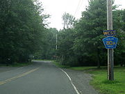
- CR 80A is a 0.1 mile (0.160934 km) spur from CR 80 to CR 85 along a Grandview Avenue extension in Montebello.
- CR 80B was a 0.2 mile (0.321868 km) one-way spur from CR 33 to CR 80 along Old Hempstead Road in New City.