
.gif)
County Route 33 (Rockland County, New York)
Encyclopedia
County Route 33 is a 13.3 miles (21.4 km) south–north county route in the central part of Rockland County, New York
. Prior to 1970, portions of CR 33 were designated as the old route of New York State Route 304. Today, CR 33 serves as an alternative route for NY 304 from Pearl River to New City where NY 304 ends at US 9W. North of New City, CR 33 serves as an alternative route for the US 9W/US 202 multiplex in northern Rockland County.
CR 33 is the longest county route in Rockland, and in fact is longer than all NY state routes within the county except for NY 59 (only shorter by three-quarters of a mile). CR 33 intersects several major west–east roads within in the county. It even intersects the Palisades Interstate Parkway
at Exit 10 in New City. CR 33 has one present child-route in CR 33A in Nanuet, and until recently had three with CR 33B located in New City and CR 33C located in Stony Point.
 CR 33 begins at NY 304 in Pearl River, and ends at CR 106 (Old NY 210
) in Stony Point. CR 33 runs through Pearl River, Nanuet, New City, Garnerville, and Stony Point. CR 33 is an alternate route for NY 304 from Pearl River to New City, and an alternate route for US 9W/US 202 from Garnerville to Stony Point. Between New City and Garnerville, CR 33 goes up Hi-Tor Mountain through Hi-Tor State Park. Unlike most the county routes in Rockland, CR 33 runs through many business areas. It cuts through downtown Garnerville, Nanuet, and Pearl River. In fact, CR 33 is a primary access road for the Nanuet Mall. Only in New City does CR 33 serve really as a residential road.
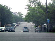
 CR 33 begins at NY 304 in Pearl River just a half a mile north of the New Jersey border. For the first 0.6 mile (0.965604 km), CR 33 runs in a west–east direction through downtown Pearl River (Central Avenue) When CR 33 reaches Middletown Road, it turns north through the northern portions of Pearl River. CR 33 serves as the primary road throughout business areas of Pearl River. CR 33 then intersects NY 304 for the second time in Pearl River and heads north into Nanuet.
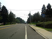
Like in Pearl River, CR 33 spilts downtown Nanuet with intersections with CR 42, CR 46, and its child-route, CR 33A. Here CR 33 is still named Middletown Road, but it is also considered Main Street within the business district of Nanuet. As CR 33 leaves downtown Nanuet, it has a rather busy intersection with NY 59. This is because the Nanuet Mall and the Rockland Plaza strip mall are located at this intersection. After this intersection, CR 33 proceeds north into residential areas of Nanuet running parallel to NY 304. Here it meets CR 60 at Smith Road.
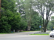
 As CR 33 enters New City it has its intersection with the Palisades Interstate Parkway
at Exit 10. This intersection is rather large as it also includes Germonds Road and West Clarkstown Road, which are major roads in New City. As CR 33 crosses the PIP, it changes from Middletown Road into Little Tor Road. It then proceeds north into residential New City with intersections with CR 76 and CR 80
. Its intersection with CR 80 marks the intersection with the two longest county routes in Rockland. CR 33 continues north through New City for another 2.6 miles (4.2 km) before beginning its trek through Hi-Tor State Park. CR 33 spends two miles (3 km) climbing and descending Hi-Tor Mountain. At its summit, drivers going southbound can see into New York City on a clear day. As CR 33 leaves Hi-Tor Park it enters the village of Garnerville.
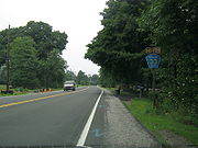
Here, CR 33 intersects and joins US 202 for a third of a mile before turning north. It crosses CR 94 in downtown Garnerville. In fact, this used to be the former eastern terminus of CR 94, until it was extended beyond US 9W/US 202 in West Haverstraw. CR 33 then proceeds into the town of Stony Point for the final mile and a half of its run. It intersects CR 98 and CR 100 before coming to an end at CR 106
. It really would be impossible to extend CR 33 further north as Bear Mountain State Park
lies close to its northern terminus.
Rockland County, New York
Rockland County is a suburban county 15 miles to the northwest of Manhattan and part of the New York City Metropolitan Area, in the U.S. state of New York. It is the southernmost county in New York west of the Hudson River, and the smallest county in New York outside of New York City. The...
. Prior to 1970, portions of CR 33 were designated as the old route of New York State Route 304. Today, CR 33 serves as an alternative route for NY 304 from Pearl River to New City where NY 304 ends at US 9W. North of New City, CR 33 serves as an alternative route for the US 9W/US 202 multiplex in northern Rockland County.
CR 33 is the longest county route in Rockland, and in fact is longer than all NY state routes within the county except for NY 59 (only shorter by three-quarters of a mile). CR 33 intersects several major west–east roads within in the county. It even intersects the Palisades Interstate Parkway
Palisades Interstate Parkway
The Palisades Interstate Parkway is a long limited-access highway in the U.S. states of New Jersey and New York. The parkway is a major commuter route into New York City from Rockland and Orange counties in New York and Bergen County in New Jersey...
at Exit 10 in New City. CR 33 has one present child-route in CR 33A in Nanuet, and until recently had three with CR 33B located in New City and CR 33C located in Stony Point.
Route description
New York State Route 210
New York State Route 210 is a state highway in Orange County, New York, in the United States. It runs north from the New Jersey state line—where it continues south as Passaic County Route 511 —along the west shore of Greenwood Lake to the eponymous village of Greenwood Lake, where it...
) in Stony Point. CR 33 runs through Pearl River, Nanuet, New City, Garnerville, and Stony Point. CR 33 is an alternate route for NY 304 from Pearl River to New City, and an alternate route for US 9W/US 202 from Garnerville to Stony Point. Between New City and Garnerville, CR 33 goes up Hi-Tor Mountain through Hi-Tor State Park. Unlike most the county routes in Rockland, CR 33 runs through many business areas. It cuts through downtown Garnerville, Nanuet, and Pearl River. In fact, CR 33 is a primary access road for the Nanuet Mall. Only in New City does CR 33 serve really as a residential road.
Like in Pearl River, CR 33 spilts downtown Nanuet with intersections with CR 42, CR 46, and its child-route, CR 33A. Here CR 33 is still named Middletown Road, but it is also considered Main Street within the business district of Nanuet. As CR 33 leaves downtown Nanuet, it has a rather busy intersection with NY 59. This is because the Nanuet Mall and the Rockland Plaza strip mall are located at this intersection. After this intersection, CR 33 proceeds north into residential areas of Nanuet running parallel to NY 304. Here it meets CR 60 at Smith Road.
Palisades Interstate Parkway
The Palisades Interstate Parkway is a long limited-access highway in the U.S. states of New Jersey and New York. The parkway is a major commuter route into New York City from Rockland and Orange counties in New York and Bergen County in New Jersey...
at Exit 10. This intersection is rather large as it also includes Germonds Road and West Clarkstown Road, which are major roads in New City. As CR 33 crosses the PIP, it changes from Middletown Road into Little Tor Road. It then proceeds north into residential New City with intersections with CR 76 and CR 80
County Route 80 (Rockland County, New York)
County Route 80 is a west–east county route in the central part of Rockland County, New York. CR 80 serves as an alternative route for NY 59 and the New York State Thruway . In fact, CR 80 is the only route besides those two major routes that runs completely from the...
. Its intersection with CR 80 marks the intersection with the two longest county routes in Rockland. CR 33 continues north through New City for another 2.6 miles (4.2 km) before beginning its trek through Hi-Tor State Park. CR 33 spends two miles (3 km) climbing and descending Hi-Tor Mountain. At its summit, drivers going southbound can see into New York City on a clear day. As CR 33 leaves Hi-Tor Park it enters the village of Garnerville.
Here, CR 33 intersects and joins US 202 for a third of a mile before turning north. It crosses CR 94 in downtown Garnerville. In fact, this used to be the former eastern terminus of CR 94, until it was extended beyond US 9W/US 202 in West Haverstraw. CR 33 then proceeds into the town of Stony Point for the final mile and a half of its run. It intersects CR 98 and CR 100 before coming to an end at CR 106
County Route 106 (Rockland County, New York)
County Route 106 is the continuation of Orange County Route 106 in Rockland County, New York. The route is long and heads east–west through Harriman State Park. The route originated as New York State Route 210 and as County Highway 416 back in the 1920s and 1930s...
. It really would be impossible to extend CR 33 further north as Bear Mountain State Park
Bear Mountain State Park
Bear Mountain State Park is located on the west side of the Hudson River in Orange and Rockland counties of New York. The park offers biking, hiking, boating, picnicking, swimming, cross-country skiing, cross-country running, sledding and ice skating...
lies close to its northern terminus.
History
Prior to 1970, portions of CR 33 were designated as the old route of NY 304.Suffixed routes
- CR 33A- Route 33A is a 0.1 mile (0.160934 km) spur from CR 33 to CR 46 along Old Middletown Road in Nanuet.
- CR 33B- Route 33B was a 0.4 mile (0.643736 km) business route that began and ended at CR 33 in New City. It ran along Old Middletown Road and the western terminus of Kings Highway.
- CR 33C- Route 33C was barely a 0.1 mile (0.160934 km) spur from CR 33 to a dead end along an extension of Central Highway in Stony Point.