
List of National Historic Landmarks in North Carolina
Encyclopedia
This is a List of National Historic Landmarks in North Carolina.
North Carolina has 38 National Historic Landmarks:
North Carolina has 38 National Historic Landmarks:
| Landmark name | Image | Year listed | Locality | County | Description | |
|---|---|---|---|---|---|---|
| Bentonville Battlefield Bentonville Battlefield Bentonville Battleground, also known as Bentonville Battleground State Historic Site, was the location in North Carolina of the Battle of Bentonville in the waning days of the American Civil War.... |
image pending | Bentonville and Newton Grove Newton Grove, North Carolina Newton Grove, chartered in 1879, is a town in Sampson County, North Carolina, United States. The population was 606 at the 2000 census.-Geography:Newton Grove is located at .... |
Johnston Johnston County, North Carolina -Major highways:* Interstate 40* Interstate 95* U.S. Highway 70* U.S. Highway 301* U.S. Highway 701-Demographics:As of the census of 2000, there were 121,965 people, 46,595 households, and 33,688 families residing in the county. The population density was 154 people per square mile . There were... |
Site of Battle of Bentonville Battle of Bentonville At 3 p.m., Confederate infantry from the Army of Tennessee launched an attack and drove the Union left flank back in confusion, nearly capturing Carlin in the process and overrunning the XIV Corps field hospital. Confederates under Maj. Gen. D.H. Hill filled the vacuum left by the retreating... |
||
| Bethabara Bethabara Historic District Bethabara Historic District was a small Moravian community located in Forsyth County, North Carolina that was first settled in 1753. It is now a National Historic Landmark and is an open air museum.-History:... |
,_old_town_(forsyth_county,_north_carolina).jpg) |
Winston-Salem Winston-Salem, North Carolina Winston-Salem is a city in the U.S. state of North Carolina, with a 2010 population of 229,617. Winston-Salem is the county seat and largest city of Forsyth County and the fourth-largest city in the state. Winston-Salem is the second largest municipality in the Piedmont Triad region and is home to... |
Forsyth Forsyth County, North Carolina -Demographics:As of the census of 2000, there were 306,067 people, 123,851 households, and 81,741 families residing in the county. The population density was 747 people per square mile . There were 133,093 housing units at an average density of 325 per square mile... |
Area of 1753 Moravian Moravians (ethnic group) Moravians are the modern West Slavic inhabitants of the historical land of Moravia, the easternmost part of the Czech Republic, which includes the Moravian Slovakia. They speak the two main groups of Moravian dialects , the transitional Bohemian-Moravian dialect subgroup and standard Czech... settlement |
||
| Bethania Historic District Bethania Historic District Bethania Historic District is a historic district in North Carolina, and remains a rare example of a Germanic-type linear agricultural village in the United States, a product of intensive historic Moravian community planning and development." The first planned Moravian settlement in Wachovia,... |
image pending | Bethania Bethania, North Carolina Bethania is the oldest municipality in Forsyth County, North Carolina, United States, and was most recently incorporated in 1995, upon the reactivation of the original 1838/1839 town charter... |
Forsyth Forsyth County, North Carolina -Demographics:As of the census of 2000, there were 306,067 people, 123,851 households, and 81,741 families residing in the county. The population density was 747 people per square mile . There were 133,093 housing units at an average density of 325 per square mile... |
|||
| Biltmore Estate Biltmore Estate Biltmore House is a Châteauesque-styled mansion near Asheville, North Carolina, built by George Washington Vanderbilt II between 1889 and 1895. It is the largest privately-owned home in the United States, at and featuring 250 rooms... |
 |
Asheville Asheville, North Carolina Asheville is a city in and the county seat of Buncombe County, North Carolina, United States. It is the largest city in Western North Carolina, and the 11th largest city in North Carolina. The City is home to the United States National Climatic Data Center , which is the world's largest active... |
Buncombe Buncombe County, North Carolina -Demographics:As of the census of 2000, there were 206,330 people, 85,776 households, and 55,668 families residing in the county. The population density was 314 people per square mile . There were 93,973 housing units at an average density of 143 per square mile... |
NRHP 66000586. Updated documentation 4/05/05 noted in PDF 007. | ||
| W. T. Blackwell and Company Tobacco Factory W. T. Blackwell and Company Tobacco Factory W.T. Blackwell & Co. Tobacco Factory, also known as Bull Durham Tobacco Factory is a tobacco factory in Durham, North Carolina.The W.T. Blackwell Company was started as a partnership between W.T. Blackwell and Julian S. Carr. Construction of the main factory building was completed in 1874.It was... |
 |
Durham Durham, North Carolina Durham is a city in the U.S. state of North Carolina. It is the county seat of Durham County and also extends into Wake County. It is the fifth-largest city in the state, and the 85th-largest in the United States by population, with 228,330 residents as of the 2010 United States census... 35.995457°N 78.903959°W |
Durham Durham County, North Carolina -Demographics:As of the census of 2000, there were 223,314 people, 89,015 households, and 54,032 families residing in the county. The population density was 769 people per square mile . There were 95,452 housing units at an average density of 329 per square mile... |
Also known as Bull Durham Tobacco Factory. | ||
| Blandwood | 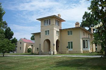 |
Greensboro Greensboro, North Carolina Greensboro is a city in the U.S. state of North Carolina. It is the third-largest city by population in North Carolina and the largest city in Guilford County and the surrounding Piedmont Triad metropolitan region. According to the 2010 U.S... 36.070384°N 79.795425°W |
Guilford Guilford County, North Carolina Guilford County is a county located in the U.S. state of North Carolina. In 2010, the Census Bureau estimated the county's population to be 491,230. Its seat is Greensboro. Since 1938, an additional county court has been located in High Point, North Carolina, making Guilford one of only a handful... |
NRHP 70000455 | ||
| Cape Hatteras Light Station Cape Hatteras Light Cape Hatteras Light is a lighthouse located on Hatteras Island in the Outer Banks of North Carolina near the community of Buxton, and is part of the Cape Hatteras National Seashore.... |
 |
Buxton Buxton, North Carolina Buxton is an unincorporated community of nearly 1,500 people on Hatteras Island near Cape Hatteras. It is located in Dare County in the U.S. state of North Carolina. North Carolina Highway 12 links the community to other Outer Banks communities such as Avon, Frisco, and Hatteras... |
Dare Dare County, North Carolina -National protected areas:* Alligator River National Wildlife Refuge * Cape Hatteras National Seashore * Fort Raleigh National Historic Site* Pea Island National Wildlife Refuge* Wright Brothers National Memorial-Demographics:... |
At 208 feet (63.4 m) tall, tallest lighthouse Lighthouse A lighthouse is a tower, building, or other type of structure designed to emit light from a system of lamps and lenses or, in older times, from a fire, and used as an aid to navigation for maritime pilots at sea or on inland waterways.... in the United States. |
||
| Capitol (North Carolina) North Carolina State Capitol The North Carolina State Capitol is the main house of government of the U.S. state of North Carolina. Housing the offices of the Governor of North Carolina, it is located in the state capital of Raleigh on Union Square at One East Edenton Street. The cornerstone of the Greek Revival building was... |
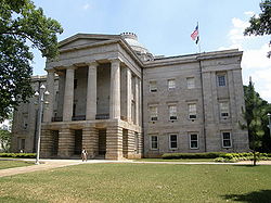 |
Raleigh Raleigh, North Carolina Raleigh is the capital and the second largest city in the state of North Carolina as well as the seat of Wake County. Raleigh is known as the "City of Oaks" for its many oak trees. According to the U.S. Census Bureau, the city's 2010 population was 403,892, over an area of , making Raleigh... 35.7812487429°N 78.6388970457°W |
Wake Wake County, North Carolina Wake County is a county located in the U.S. state of North Carolina. As of the 2010 census, the population was 900,993 making it North Carolina's second most populated county... |
Capitol building, part of Capitol Area Historic District Capitol Area Historic District The Capitol Area Historic District in Raleigh, North Carolina is a historic district listed in 1978 on the National Register of Historic Places. It may include the following separately listed buildings:*North Carolina State Capitol,... . |
||
| Chowan County Courthouse Chowan County Courthouse Chowan County Courthouse is a Georgian style building in Edenton, North Carolina.It was declared a National Historic Landmark in 1970.It is located on East King Street, at the head of Green Street, in Edenton.... |
.jpg) |
Edenton Edenton, North Carolina Edenton is a town in Chowan County, North Carolina, United States. The population was 4,966 at the 2008 census. It is the county seat of Chowan County. Edenton is located in North Carolina's Inner Banks region. In recent years Edenton has become a popular retirement location and a destination for... 36.055968023°N 76.6083370785°W |
Chowan Chowan County, North Carolina - Law and government :Chowan County is a member of the Albemarle Commission regional council of government-Demographics:As of the census of 2010, there were 14,793 people, 5,580 households, and 4,006 families residing in the county. The population density was 84 people per square mile . There... |
NRHP 70000447 | ||
| Christ Episcopal Church Christ Episcopal Church (Raleigh, North Carolina) Christ Episcopal Church is an Episcopal church in Raleigh, North Carolina located on Edenton Street.It is located within Capitol Area Historic District, a National Historic Landmark district and has a distinctive bronze weather vane at the peak of its steeple... |
Raleigh Raleigh, North Carolina Raleigh is the capital and the second largest city in the state of North Carolina as well as the seat of Wake County. Raleigh is known as the "City of Oaks" for its many oak trees. According to the U.S. Census Bureau, the city's 2010 population was 403,892, over an area of , making Raleigh... 35.781146°N 78.637648°W |
Wake Wake County, North Carolina Wake County is a county located in the U.S. state of North Carolina. As of the 2010 census, the population was 900,993 making it North Carolina's second most populated county... |
Perhaps earliest Gothic architecture Gothic architecture Gothic architecture is a style of architecture that flourished during the high and late medieval period. It evolved from Romanesque architecture and was succeeded by Renaissance architecture.... church in the South, designed in 1846 by Richard Upjohn Richard Upjohn Richard Upjohn was an English-born architect who emigrated to the United States and became most famous for his Gothic Revival churches. He was partially responsible for launching the movement to such popularity in the United States. Upjohn also did extensive work in and helped to popularize the... |
|||
| Connemara, The Carl Sandburg Farm Carl Sandburg Home National Historic Site Carl Sandburg Home National Historic Site, located near Hendersonville in Flat Rock, North Carolina, preserves Connemara Farms, the home of Pulitzer Prize-winning poet and writer Carl Sandburg... |
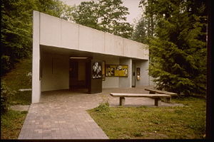 |
Flat Rock Flat Rock, North Carolina Flat Rock is the name of some places in the U.S. state of North Carolina:*Flat Rock, Henderson County, North Carolina *Flat Rock, Stokes County, North Carolina... |
Henderson Henderson County, North Carolina Henderson County is a county located in the U.S. state of North Carolina. It is part of the Asheville, North Carolina, Metropolitan Statistical Area. As of 2008, the population was 102,367. Its county seat is Hendersonville.- History :... |
|||
| Cooleemee Cooleemee Cooleemee, also known as the Cooleemee Plantation House, is a house located between Mocksville and Lexington, North Carolina, at the terminus of SR 1812 on the Yadkin River in Davie County, North Carolina. It is a U.S... |
Mocksville Mocksville, North Carolina Mocksville is a town in Davie County, North Carolina, USA. The population was 4,178 at the 2000 census. It is the county seat of Davie County.-Geography:Mocksville is located at .... |
Davie Davie County, North Carolina - Wine region :Portions of Davie County are located in the Yadkin Valley AVA, an American Viticultural Area. Wines made from grapes grown in the Yadkin Valley AVA may use the appellation Yadkin Valley on their labels.-Demographics:... |
Plantation | |||
| Coolmore Coolmore Plantation Coolmore Plantation, also known as Coolmore is a plantation near Tarboro, North Carolina.It was declared a National Historic Landmark in 1978.It is located on North Carolina Highway 3 west of Tarboro.-References:... |
.jpg) |
Tarboro Tarboro, North Carolina Tarboro is a city located in Edgecombe County, North Carolina. It is part of the Rocky Mount, North Carolina Metropolitan Statistical Area. As of 2010, the town had a total population of 13,121. It is the county seat of Edgecombe County. Tarboro is located in North Carolina's Inner Banks region... |
Edgecombe Edgecombe County, North Carolina -Demographics:As of the census of 2000, there were 55,606 people, 20,392 households, and 14,804 families residing in the county. The population density was 110 people per square mile . There were 24,002 housing units at an average density of 48 per square mile... |
Plantation | ||
| Cupola House | .jpg) |
Edenton Edenton, North Carolina Edenton is a town in Chowan County, North Carolina, United States. The population was 4,966 at the 2008 census. It is the county seat of Chowan County. Edenton is located in North Carolina's Inner Banks region. In recent years Edenton has become a popular retirement location and a destination for... 36.057856°N 76.609261°W |
Chowan Chowan County, North Carolina - Law and government :Chowan County is a member of the Albemarle Commission regional council of government-Demographics:As of the census of 2010, there were 14,793 people, 5,580 households, and 4,006 families residing in the county. The population density was 84 people per square mile . There... |
A house with a cupola Cupola In architecture, a cupola is a small, most-often dome-like, structure on top of a building. Often used to provide a lookout or to admit light and air, it usually crowns a larger roof or dome.... |
||
| Josephus Daniels House Josephus Daniels House Josephus Daniels House, also known as Wakestone or Masonic Temple of Raleigh, was the home of Josephus Daniels, who was Secretary of the Navy under President Woodrow Wilson.It was declared a National Historic Landmark in 1976.... |
image pending | Raleigh Raleigh, North Carolina Raleigh is the capital and the second largest city in the state of North Carolina as well as the seat of Wake County. Raleigh is known as the "City of Oaks" for its many oak trees. According to the U.S. Census Bureau, the city's 2010 population was 403,892, over an area of , making Raleigh... 35.798937°N 78.647597°W |
Wake Wake County, North Carolina Wake County is a county located in the U.S. state of North Carolina. As of the 2010 census, the population was 900,993 making it North Carolina's second most populated county... |
Home of Josephus Daniels Josephus Daniels Josephus Daniels was a newspaper editor and publisher from North Carolina who was appointed by United States President Woodrow Wilson to serve as Secretary of the Navy during World War I... |
||
| Duke Homestead and Tobacco Factory Duke Homestead and Tobacco Factory Duke Homestead State Historic Site is a National Historic Landmark and a state historic location in Durham, North Carolina. -History:Duke Homestead was originally owned by Washington Duke in the 19th century... |
Durham Durham, North Carolina Durham is a city in the U.S. state of North Carolina. It is the county seat of Durham County and also extends into Wake County. It is the fifth-largest city in the state, and the 85th-largest in the United States by population, with 228,330 residents as of the 2010 United States census... |
Durham Durham County, North Carolina -Demographics:As of the census of 2000, there were 223,314 people, 89,015 households, and 54,032 families residing in the county. The population density was 769 people per square mile . There were 95,452 housing units at an average density of 329 per square mile... |
Homestead and factory of Washington Duke Washington Duke George Washington Duke was an American tobacco industrialist and philanthropist.-Biography:Duke was born in Orange County, North Carolina , to Taylor Duke and Dicey Jones... |
|||
| Fort Fisher Fort Fisher Fort Fisher was a Confederate fort during the American Civil War. It protected the vital trading routes of the port at Wilmington, North Carolina, from 1861 until its capture by the Union in 1865.... |
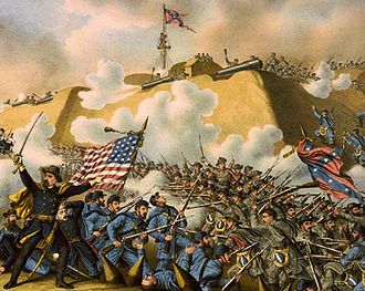 |
Wilmington Wilmington, North Carolina Wilmington is a port city in and is the county seat of New Hanover County, North Carolina, United States. The population is 106,476 according to the 2010 Census, making it the eighth most populous city in the state of North Carolina... |
New Hanover New Hanover County, North Carolina -Demographics:As of the census of 2000, there were 160,307 people, 68,183 households, and 41,591 families residing in the county. The population density was 806 people per square mile . There were 79,616 housing units at an average density of 400 per square mile... |
A fort | ||
| Guilford Court House Battlefield Guilford Courthouse National Military Park Guilford Courthouse National Military Park, at 2332 New Garden Road in Greensboro, North Carolina, commemorates the Battle of Guilford Court House, fought on March 15, 1781. This battle opened the campaign that led to American victory in the Revolutionary War. The losses by the British in this... |
 |
Greensboro Greensboro, North Carolina Greensboro is a city in the U.S. state of North Carolina. It is the third-largest city by population in North Carolina and the largest city in Guilford County and the surrounding Piedmont Triad metropolitan region. According to the 2010 U.S... |
Guilford Guilford County, North Carolina Guilford County is a county located in the U.S. state of North Carolina. In 2010, the Census Bureau estimated the county's population to be 491,230. Its seat is Greensboro. Since 1938, an additional county court has been located in High Point, North Carolina, making Guilford one of only a handful... |
Partially preserved site of American Revolutionary War American Revolutionary War The American Revolutionary War , the American War of Independence, or simply the Revolutionary War, began as a war between the Kingdom of Great Britain and thirteen British colonies in North America, and ended in a global war between several European great powers.The war was the result of the... 's Battle of Guilford Court House Battle of Guilford Court House The Battle of Guilford Court House was a battle fought on March 15, 1781 in Greensboro, the county seat of Guilford County, North Carolina, during the American Revolutionary War... |
||
| Hardaway Site Hardaway Site Hardaway Site, also known as 31ST4, is an archaeological site near Badin, North Carolina. It preserves remains of prehistory, and is also important in the history of archeological methodology.It was declared a National Historic Landmark in 1990.... |
image pending | Badin Badin, North Carolina Badin is a town located in Stanly County, North Carolina. As of the 2000 census, the town had a total population of 1,154.-Geography:Badin is located at 35°24'17" North, 80°6'57" West .... |
Stanly Stanly County, North Carolina -Demographics:As of the census of 2010, there were 60,585 people. In 2000 there were 22,223 households, and 16,156 families residing in the county. The population density was 147 people per square mile . There were 24,582 housing units at an average density of 62 per square mile... |
An archaeological site Archaeological site An archaeological site is a place in which evidence of past activity is preserved , and which has been, or may be, investigated using the discipline of archaeology and represents a part of the archaeological record.Beyond this, the definition and geographical extent of a 'site' can vary widely,... |
||
| Hayes Plantation Hayes Plantation Hayes Plantation, also known as Hayes Farm, is a historic plantation near Edenton, North Carolina that belonged to Samuel Johnston , who served as Governor of North Carolina from 1787 to 1789. Johnston become one of the state's first two United States Senators, serving from 1789 until 1793, and... |
.jpg) |
Edenton Edenton, North Carolina Edenton is a town in Chowan County, North Carolina, United States. The population was 4,966 at the 2008 census. It is the county seat of Chowan County. Edenton is located in North Carolina's Inner Banks region. In recent years Edenton has become a popular retirement location and a destination for... 36.0481889546°N 76.6022287664°W |
Chowan Chowan County, North Carolina - Law and government :Chowan County is a member of the Albemarle Commission regional council of government-Demographics:As of the census of 2010, there were 14,793 people, 5,580 households, and 4,006 families residing in the county. The population density was 84 people per square mile . There... |
A plantation | ||
| Hinton Rowan Helper House Hinton Rowan Helper House Hinton Rowan Helper House, the residence of Hinton Rowan Helper from 1829-49 also known as Evans Place is a house in Mocksville, North Carolina.It was declared a National Historic Landmark in 1973.... |
image pending | Mocksville Mocksville, North Carolina Mocksville is a town in Davie County, North Carolina, USA. The population was 4,178 at the 2000 census. It is the county seat of Davie County.-Geography:Mocksville is located at .... 35.9051370299°N 80.6047239139°W |
Davie Davie County, North Carolina - Wine region :Portions of Davie County are located in the Yadkin Valley AVA, an American Viticultural Area. Wines made from grapes grown in the Yadkin Valley AVA may use the appellation Yadkin Valley on their labels.-Demographics:... |
A house | ||
| Market House | 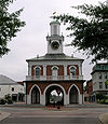 |
Fayetteville Fayetteville, North Carolina Fayetteville is a city located in Cumberland County, North Carolina, United States. It is the county seat of Cumberland County, and is best known as the home of Fort Bragg, a U.S. Army post located northwest of the city.... 35.0509912673°N 78.8777807012°W |
Cumberland Cumberland County, North Carolina -Demographics:As of the census of 2000, there were 302,963 people, 107,358 households, and 77,619 families residing in the county. The population density was 464 people per square mile . There were 118,425 housing units at an average density of 181 per square mile... |
Market below, town hall above | ||
| USS MONITOR (Shipwreck) USS Monitor USS Monitor was the first ironclad warship commissioned by the United States Navy during the American Civil War. She is most famous for her participation in the Battle of Hampton Roads on March 9, 1862, the first-ever battle fought between two ironclads... |
 |
Cape Hatteras |
Dare Dare County, North Carolina -National protected areas:* Alligator River National Wildlife Refuge * Cape Hatteras National Seashore * Fort Raleigh National Historic Site* Pea Island National Wildlife Refuge* Wright Brothers National Memorial-Demographics:... |
NRHP 74002299. shipwreck (ironclad Ironclad warship An ironclad was a steam-propelled warship in the early part of the second half of the 19th century, protected by iron or steel armor plates. The ironclad was developed as a result of the vulnerability of wooden warships to explosive or incendiary shells. The first ironclad battleship, La Gloire,... ). |
||
| Nash-Hooper House Nash-Hooper House Nash-Hooper House, also known as William Hooper House is a site significant for its association with Francis Nash and William Hooper. Nash, who was an "American Revolutionary War hero and general who was killed at the Battle of Germantown in 1777, had built the house in 1772... |
.jpg) |
Hillsborough Hillsborough, North Carolina Hillsborough is a town in Orange County, North Carolina, United States. The population was 5,653 at the 2008 census. It is the county seat of Orange County.... 36.077058°N 79.100232°W |
Orange Orange County, North Carolina Orange County is a county located in the U.S. state of North Carolina. As of the 2010 census, the population was 133,801. Its county seat is Hillsborough... |
NRHP 71000610 | ||
| North Carolina Mutual Life Insurance Company Building North Carolina Mutual Life Insurance Company Building North Carolina Mutual Life Insurance Company Building, also known as Mechanics and Farmers Bank, is an office building in downtown Durham, North Carolina.It was declared a National Historic Landmark in 1975.... |
image pending | Durham Durham, North Carolina Durham is a city in the U.S. state of North Carolina. It is the county seat of Durham County and also extends into Wake County. It is the fifth-largest city in the state, and the 85th-largest in the United States by population, with 228,330 residents as of the 2010 United States census... 35.995972°N 78.900951°W |
Durham Durham County, North Carolina -Demographics:As of the census of 2000, there were 223,314 people, 89,015 households, and 54,032 families residing in the county. The population density was 769 people per square mile . There were 95,452 housing units at an average density of 329 per square mile... |
NRHP 75001258 | ||
| USS NORTH CAROLINA (Battleship) USS North Carolina (BB-55) USS North Carolina was the lead ship of her class of battleship and the fourth in the United States Navy to be named in honor of this U.S. state. She was the first new-construction U.S. battleship to enter service during World War II, participating in every major naval offensive in the Pacific... |
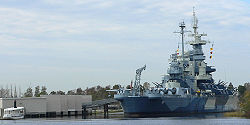 |
Wilmington Wilmington, North Carolina Wilmington is a port city in and is the county seat of New Hanover County, North Carolina, United States. The population is 106,476 according to the 2010 Census, making it the eighth most populous city in the state of North Carolina... 34.2348996472°N 77.9428548034°W |
New Hanover New Hanover County, North Carolina -Demographics:As of the census of 2000, there were 160,307 people, 68,183 households, and 41,591 families residing in the county. The population density was 806 people per square mile . There were 79,616 housing units at an average density of 400 per square mile... |
NRHP 82004893. USS North Carolina USS North Carolina (BB-55) USS North Carolina was the lead ship of her class of battleship and the fourth in the United States Navy to be named in honor of this U.S. state. She was the first new-construction U.S. battleship to enter service during World War II, participating in every major naval offensive in the Pacific... (battleship Battleship A battleship is a large armored warship with a main battery consisting of heavy caliber guns. Battleships were larger, better armed and armored than cruisers and destroyers. As the largest armed ships in a fleet, battleships were used to attain command of the sea and represented the apex of a... ). |
||
| Old East Old East Old East is a dormitory building located at the north part of campus in University of North Carolina at Chapel Hill. When it was built in 1793, it became the first state university building in the United States... |
Chapel Hill Chapel Hill, North Carolina Chapel Hill is a town in Orange County, North Carolina, United States and the home of the University of North Carolina at Chapel Hill and UNC Health Care... 35.9106179574°N 79.0507497594°W |
Orange Orange County, North Carolina Orange County is a county located in the U.S. state of North Carolina. As of the 2010 census, the population was 133,801. Its county seat is Hillsborough... |
First building of first state university in the United States, built in 1795 | |||
| Old Salem Historic District Old Salem Old Salem is a historic district of Winston-Salem, North Carolina. It features a living history museum that interprets the restored Moravian community. The non-profit organization began its work in 1950, although some private residents had restored buildings earlier... |
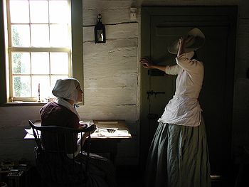 |
Winston-Salem Winston-Salem, North Carolina Winston-Salem is a city in the U.S. state of North Carolina, with a 2010 population of 229,617. Winston-Salem is the county seat and largest city of Forsyth County and the fourth-largest city in the state. Winston-Salem is the second largest municipality in the Piedmont Triad region and is home to... |
Forsyth Forsyth County, North Carolina -Demographics:As of the census of 2000, there were 306,067 people, 123,851 households, and 81,741 families residing in the county. The population density was 747 people per square mile . There were 133,093 housing units at an average density of 325 per square mile... |
NRHP 66000591 | ||
| Palmer-Marsh House Palmer-Marsh House Palmer-Marsh House was built in 1744 as a combination residence and place of business located in Bath, North Carolina.It was declared a National Historic Landmark in 1970.It is located on the east side of Main Street, just south of Carteret Street .... |
.jpg) |
Bath Bath, North Carolina Bath is a town in Beaufort County, North Carolina, United States. The population was 268 at the 2008 census. Incorporated in 1705, Bath was North Carolina's first port of entry. Bath is North Carolina's oldest town, celebrating its 300th anniversary in 2005... 35.4748703911°N 76.8141701694°W |
Beaufort Beaufort County, North Carolina - Law and government :Beaufort County is a member of the Mid-East Commission regional council of governments.Beaufort County is one of the proposed sites for a Navy outlying landing field. This practice airfield would allow pilots to simulate landings on an aircraft carrier... |
NRHP 70000439 | ||
| Pinehurst Historic District Pinehurst Resort Pinehurst Resort is a historic upmarket golf resort at Pinehurst, North Carolina, USA. It has hosted a number of prestigious golf tournaments.-History:... |
 |
Pinehurst Pinehurst, North Carolina Pinehurst is a village in Moore County, North Carolina, United States. The population was 9,706 at the 2000 census. It is the location of the Pinehurst Resort, venue of the 1936 PGA Championship, the 1951 Ryder Cup. The host site for the 1999, 2005,& 2014 U.S. Open Golf Championships, the 2008 U.S.... |
Moore Moore County, North Carolina Moore County is a county located in the U.S. state of North Carolina. As of 2000, the population was 74,769. Its county seat is Carthage.- History :The county was formed in 1784 from Cumberland County... |
A historic upmarket golf resort | ||
| Playmakers Theatre Playmakers Theatre Playmakers Theatre, also known as Smith Hall, is a Greek Revival temple built in 1850, that was originally designed by New York architect Alexander Jackson Davis as Smith Hall, a combined library and ballroom. After also being used as a laboratory, bath house, and law school, it became a theater... |
Chapel Hill Chapel Hill, North Carolina Chapel Hill is a town in Orange County, North Carolina, United States and the home of the University of North Carolina at Chapel Hill and UNC Health Care... 35.9047537099°N 79.0504504318°W |
Orange Orange County, North Carolina Orange County is a county located in the U.S. state of North Carolina. As of the 2010 census, the population was 133,801. Its county seat is Hillsborough... |
NRHP 71000605 | |||
| Reed Gold Mine Reed Gold Mine The Reed Gold Mine is located in Midland, Cabarrus County, North Carolina, and is the site of the first documented commercial gold find in the United States... |
Concord Concord, North Carolina Concord is a city in the U.S. state of North Carolina. According to Census 2010, the city has a current population of 79,066. It is the largest city in Cabarrus County and is the county seat. In terms of population, the city of Concord is the second largest city in the Charlotte Metropolitan Area... |
Cabarrus Cabarrus County, North Carolina -Demographics:As of the census of 2000, there were 131,063 people, 49,519 households, and 36,545 families residing in the county. The population density was 360 people per square mile . There were 52,848 housing units at an average density of 145 per square mile... |
NRHP 66000587. Site of first gold discovery in United States | |||
| Salem Tavern Salem Tavern Salem Tavern was a tavern in the 18th century town of Salem, North Carolina, now within the city of Winston-Salem, North Carolina. It is part of Old Salem Museums & Gardens and open as an Old Salem tour building to visitors.... |
.jpg) |
Winston-Salem Winston-Salem, North Carolina Winston-Salem is a city in the U.S. state of North Carolina, with a 2010 population of 229,617. Winston-Salem is the county seat and largest city of Forsyth County and the fourth-largest city in the state. Winston-Salem is the second largest municipality in the Piedmont Triad region and is home to... 36.085336°N 80.241745°W |
Forsyth Forsyth County, North Carolina -Demographics:As of the census of 2000, there were 306,067 people, 123,851 households, and 81,741 families residing in the county. The population density was 747 people per square mile . There were 133,093 housing units at an average density of 325 per square mile... |
NRHP 66000592 | ||
| Single Brothers' House Single Brothers' House The Single Brothers' House was built to house the Single Brethren, the unmarried men, of the Moravian Congregation of Salem, now Winston-Salem, North Carolina. The first portion designed by Friedrich Wilhelm von Marschall, secular leader of the Moravian colony, was constructed of traditional... |
.jpg) |
Winston-Salem Winston-Salem, North Carolina Winston-Salem is a city in the U.S. state of North Carolina, with a 2010 population of 229,617. Winston-Salem is the county seat and largest city of Forsyth County and the fourth-largest city in the state. Winston-Salem is the second largest municipality in the Piedmont Triad region and is home to... 36.087560°N 80.242105°W |
Forsyth Forsyth County, North Carolina -Demographics:As of the census of 2000, there were 306,067 people, 123,851 households, and 81,741 families residing in the county. The population density was 747 people per square mile . There were 133,093 housing units at an average density of 325 per square mile... |
NRHP 70000454 | ||
| Town Creek Indian Mound Town Creek Indian Mound -External links:*, North Carolina Historic Sites... |
 |
Mount Gilead Mount Gilead, North Carolina Mount Gilead is a town in Montgomery County, North Carolina, United States. The population was 1,389 at the 2000 census.-Geography:Mount Gilead is located at .... |
Montgomery Montgomery County, North Carolina -Demographics:As of the census of 2000, there were 26,822 people, 9,848 households, and 7,189 families residing in the county. The population density was 55 people per square mile . There were 14,145 housing units at an average density of 29 per square mile... |
Archaeological site Archaeological site An archaeological site is a place in which evidence of past activity is preserved , and which has been, or may be, investigated using the discipline of archaeology and represents a part of the archaeological record.Beyond this, the definition and geographical extent of a 'site' can vary widely,... |
||
| Union Tavern Union Tavern Union Tavern was the workshop of Thomas Day, an early 19th-century free African-American cabinetmaker who achieved recognition for the superior quality of his craftsmanship."It was declared a National Historic Landmark in 1975.... |
.jpg) |
Milton Milton, North Carolina Milton is a town in Caswell County, North Carolina, United States. The population was 132 at the 2000 census. It is adjacent to the Virginia International Raceway, which is just across the NC/VA state line.-Geography:... 36.5365668647°N 79.2067849986°W |
Caswell Caswell County, North Carolina -Demographics:As of the census of 2000, there were 23,501 people, 8,670 households, and 6,398 families residing in the county. The population density was 55 people per square mile . There were 9,601 housing units at an average density of 23 per square mile... |
NRHP 75001245 | ||
| Thomas Wolfe House Thomas Wolfe House The Thomas Wolfe House, AKA the Thomas Wolfe Memorial, is a historic house and museum located at 52 N Market St. in Asheville, North Carolina, that was the childhood home of author Thomas Wolfe .... |
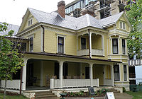 |
Asheville Asheville, North Carolina Asheville is a city in and the county seat of Buncombe County, North Carolina, United States. It is the largest city in Western North Carolina, and the 11th largest city in North Carolina. The City is home to the United States National Climatic Data Center , which is the world's largest active... 35.5956989115°N 82.5452873772°W |
Buncombe Buncombe County, North Carolina -Demographics:As of the census of 2000, there were 206,330 people, 85,776 households, and 55,668 families residing in the county. The population density was 314 people per square mile . There were 93,973 housing units at an average density of 143 per square mile... |
NRHP 71000572 | ||
| Wright Brothers National Memorial Visitor Center | Kill Devil Hills Kill Devil Hills, North Carolina Kill Devil Hills is a town in Dare County, North Carolina, USA. The population was 5,897 at the 2000 census.Nearby Kitty Hawk is frequently cited as the location of the Wright brothers' first controlled, powered airplane flights on December 17, 1903... |
Dare Dare County, North Carolina -National protected areas:* Alligator River National Wildlife Refuge * Cape Hatteras National Seashore * Fort Raleigh National Historic Site* Pea Island National Wildlife Refuge* Wright Brothers National Memorial-Demographics:... |
||||
See also
External links
- National Register Information System, National Park Service.

