

List of Grade I historic buildings in Hong Kong
Encyclopedia
Grade I historic buildings in Hong Kong
are those selected as those "outstanding merits of which every effort should be made to preserve if possible".
These buildings may be protected under the Antiquities and Monuments Ordinance
; after consulting the Antiquities Advisory Board, with the approval of the Chief Executive
and the publication of the notice in government gazette, the Antiquities Authority may legally declare the Graded historic buildings to be protected as Declared Monuments
. Five Grade I historic buildings have been demolished in the last two decades.
Note: This list is accurate as at 6 November 2009. A territory-wide grade reassessment
has been ongoing since. See this link for the latest grading update.
Central and Western District
Eastern District
Islands District
Kwun Tong District
North District
Sai Kung District
Sha Tin District
Sham Shui Po District
Southern District
Tai Po District
Tuen Mun District
Wan Chai District
Wong Tai Sin District
Yau Tsim Mong District
Yuen Long District
Hong Kong
Hong Kong is one of two Special Administrative Regions of the People's Republic of China , the other being Macau. A city-state situated on China's south coast and enclosed by the Pearl River Delta and South China Sea, it is renowned for its expansive skyline and deep natural harbour...
are those selected as those "outstanding merits of which every effort should be made to preserve if possible".
These buildings may be protected under the Antiquities and Monuments Ordinance
Antiquities and Monuments Ordinance
The Antiquities and Monuments Ordinance, in Hong Kong Law , was enacted in 1976 to preserve the objects of historical, archaeological and palaeontological interest and for matters ancillary thereto or connected therewith...
; after consulting the Antiquities Advisory Board, with the approval of the Chief Executive
Chief Executive of Hong Kong
The Chief Executive of Hong Kong is the President of the Executive Council of Hong Kong and head of the Government of the Hong Kong Special Administrative Region. The position was created to replace the Governor of Hong Kong, who was the head of the Hong Kong government during British rule...
and the publication of the notice in government gazette, the Antiquities Authority may legally declare the Graded historic buildings to be protected as Declared Monuments
Declared monuments of Hong Kong
Declared monuments of Hong Kong are places, structures or buildings legally declared to be "protected". In Hong Kong, declaring a monument requires consulting the Antiquities Advisory Board, the approval of the Chief Executive as well as the publication of the notice in government gazette.As of 12...
. Five Grade I historic buildings have been demolished in the last two decades.
Note: This list is accurate as at 6 November 2009. A territory-wide grade reassessment
Heritage conservation in Hong Kong
This article details the history and status of Heritage conservation in Hong Kong, as well as the role of various stakeholders.An indication of the size of the built heritage in Hong Kong is given by a territory-wide survey conducted by the Antiquities and Monuments Office between 1996 and 2000,...
has been ongoing since. See this link for the latest grading update.
Central and Western DistrictCentral and Western DistrictThe Central and Western District located on northern part of Hong Kong Island is one of the 18 administrative districts of Hong Kong. It had a population of 261,884 in 2001...
| Name | Location | Notes/References | Photographs |
|---|---|---|---|
| Lo Pan Temple Lo Pan Temple Lo Pan Temple which is built for the later generation to commenmorate Lo Pan is in Central and western district, No. 15 Ching Lin Terrace, Kennedy Town... |
No. 15 Ching Lin Terrace, Kennedy Town Kennedy Town Kennedy Town is at the western end of Sai Wan on Hong Kong Island in Hong Kong. It was named after Arthur Edward Kennedy, the 7th Governor of Hong Kong from 1872 to 1877... |
http://www.lcsd.gov.hk/CE/Museum/Monument/en/trails_west1.php?tid=25 | 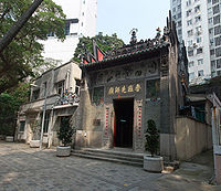 |
| Old Victoria Barracks Victoria Barracks, Hong Kong The Victoria Barracks were a barracks in the Admiralty district of Central on Hong Kong Island, Hong Kong. The barracks were constructed between the 1840s and 1874, and situated within the area bounded by Cotton Tree Drive, Kennedy Road and Queensway, Hong Kong. The Barracks with Murray Barracks,... , Former Explosives Magazine |
Justice Drive, Central Central, Hong Kong Central is the central business district of Hong Kong. It is located in Central and Western District, on the north shore of Hong Kong Island, across Victoria Harbour from Tsim Sha Tsui, the southernmost point of Kowloon Peninsula... |
http://www.conservancy.org.hk/heritage/EM_E.htm | |
| The Hong Kong Catholic Cathedral of Immaculate Conception Immaculate Conception Cathedral of Hong Kong The Hong Kong Catholic Cathedral of the Immaculate Conception is the Roman Catholic Cathedral of the Catholic Diocese of Hong Kong. It is the seat of the Diocesan bishop, currently John Tong. The Cathedral is one of the two cathedrals in the territory of Hong Kong, the other being the Anglican... |
No. 16 Caine Road Caine Road Caine Road is a main road in Hong Kong connecting Bonham Road in the west and Arbuthnot Road and Upper Albert Road in the east .... , Central Central, Hong Kong Central is the central business district of Hong Kong. It is located in Central and Western District, on the north shore of Hong Kong Island, across Victoria Harbour from Tsim Sha Tsui, the southernmost point of Kowloon Peninsula... |
http://www.amo.gov.hk/en/trails_central3.php?tid=c19 |  |
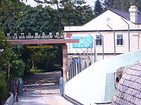
| West Point Filters Bungalow | No. 50 Kotewall Road Kotewall Road Kotewall Road, , is a road in Mid-Levels, Hong Kong Island. Located between Po Shan Road and Robinson Road.- The name :Sir Robert Hormus Kotewall was a prominent businessman. In 1913, he was named Clerk to the Magistracy and JP. By 1919, Dr Kotewall was in trade as the manager of the Hong Kong... , Mid-Levels Mid-levels Mid-levels is an expensive residential area on Hong Kong Island in Hong Kong. It is located halfway up Victoria Peak, directly above Central... |
Now par of the Lung Fu Shan Environmental Education Centre. | |
| Bishop's House Bishop's House The Bishop's House , located at 1 Lower Albert Road, Central, is the residence and office of the Archbishop of Hong Kong.-History:It was originally designed as a school for Chinese students and for many years housed St Paul's College. The house's origins can be dated from 1843, when Vincent Stanton... |
No. 1 Lower Albert Road Lower Albert Road Lower Albert Road is a road on the Government Hill in the Central area of the Hong Kong Special Administrative Region of the People's Republic of China. The south major entrance of Central Government Offices, where major officials work, is located at the Lower Albert Road and another common... , Central Central, Hong Kong Central is the central business district of Hong Kong. It is located in Central and Western District, on the north shore of Hong Kong Island, across Victoria Harbour from Tsim Sha Tsui, the southernmost point of Kowloon Peninsula... |
 |
|
| Jamia Mosque Jamia Mosque (Hong Kong) Jamia Mosque is an historical building in Mid-levels, Hong Kong, located at No. 30 Shelley Street... |
No. 30 Shelley Street Shelley Street Shelley Street is a street in Central, Hong Kong. It is a ladder street and the Central–Mid-levels escalators run along the entire length of the street.-Name:... , Sheung Wan Sheung Wan Sheung Wan is an area in Hong Kong, located in the north-west of Hong Kong Island, between Central and Sai Ying Pun. Administratively, it is part of the Central and Western District... |
http://www.amo.gov.hk/en/trails_sheungwan2.php?tid=5 | |
| Façade of the Old Mental Hospital Sai Ying Pun Community Complex Sai Ying Pun Community Complex is located at 2 High Street, Sai Ying Pun, Hong Kong. It is a 9-storey building built on the site of the Old Mental Hospital, of which only the granite facade and arched verandah were preserved.-History:... |
No. 2 High Street High Street, Hong Kong High Street is a one way street in Sai Ying Pun, Hong Kong, available only to minibuses and private vehicles. It connects Bonham Road in the east and Pok Fu Lam Road in the west. It runs from east to west from Western St to Pok Fu Lam Road, and from west to east from Western Street to Bonham Road... , Sai Ying Pun Sai Ying Pun Sai Ying Pun is an area in Western District on the Hong Kong Island in Hong Kong. It is part of Central and Western District in district administration.... |
http://www.amo.gov.hk/en/trails_west1.php?tid=20 Now part of the Sai Ying Pun Community Complex. |  |
| Ohel Leah Synagogue Ohel Leah Synagogue The Ohel Leah Synagogue and its next-door neighbors, the Jewish Recreation Club and the Jewish Community Center, have formed the center of Jewish social and religious life in Hong Kong for over a century... |
No. 70 Robinson Road Robinson Road, Hong Kong Robinson Road is a 2-lane, bi-directional road on the Mid-levels, Hong Kong Island, Hong Kong. In the east, it is connected with the Magazine Gap Road and Garden Road, and in the west with Babington Road and Park Road, Robinson Road is quite long. With Central-Mid-Levels escalator, it also... , at the junction with Castle Road |
http://www.amo.gov.hk/en/trails_sheungwan2.php?tid=6 | |
| Queen's Pier Queen's Pier Queen's Pier, named after Queen Victoria, was a public pier in front of City Hall in Edinburgh Place, Central, Hong Kong. For three generations it served not only as a public pier in day-to-day use but also as a major ceremonial arrival and departure point... |
Central Central, Hong Kong Central is the central business district of Hong Kong. It is located in Central and Western District, on the north shore of Hong Kong Island, across Victoria Harbour from Tsim Sha Tsui, the southernmost point of Kowloon Peninsula... , Edinburgh Place Edinburgh Place Edinburgh Place is a public square in Central, Hong Kong, adjacent to the Victoria Harbour. The Hong Kong City Hall is located in the square. In addition, the Edinburgh Place Ferry Pier and Queen's Pier were also located in the square before they were demolished in early 2007.-History:The... |
Demolition completed in February 2008 | 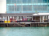 |
Eastern DistrictEastern District, Hong KongThe Eastern District is one of the 18 districts of Hong Kong. It had a population of 587,690 in 2006. The district has the second highest population while its residents have the third highest median household income among 18 districts....
| Name | Location | Notes/References | Photographs |
|---|---|---|---|
| Lyemun Barracks (The whole compound) | Lei Yue Mun Lei Yue Mun Lei Yue Mun is a short channel in Hong Kong, between Junk Bay and Victoria Harbour, separating Kowloon and Hong Kong Island. The channel is an important passage in the South China Sea. It is the east gate of Victoria Harbour.The lands around the channel are also called Lei Yue Mun... , Chai Wan Chai Wan Chai Wan , formerly mistakenly known as Sai Wan , lies at the east end of the urban area of Hong Kong Island next to Shau Kei Wan. The area is administratively part of the Eastern District, and is a mosaic of industrial and residential areas... |
 |
|
| Lyemun Barracks Block 10 | |||
| Lyemun Barracks Block 18 | |||
| Lyemun Barracks Block 21 | |
||
| Lyemun Barracks Block 25 | |||
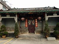
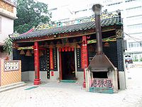
| Tam Kung Tam Kung Tam Kung or Tam Tai Sin is a sea deity worshiped in Hong Kong and Macau.In Chinese folk legends, Tam Kung was one of gods who could forecast the weather. He was born in Huizhou Prefecture. It was said that he could cure patients in his childhood. Tam Kung became an immortal in heaven at the age... Temple |
Tam Kung Temple Road, Shau Kei Wan Shau Kei Wan Shau Kei Wan or Shaukeiwan, Shaukiwan is a town in Eastern District, Hong Kong. Literally, Shau Kei means a pail, and Wan implies that the town is developed along the coast. Nowadays it is a relatively densely populated town compared with some developing areas.-Name:The name Shau Kei Wan comes... |
http://www.ctc.org.hk/en/directcontrol/temple7.asp | 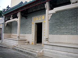 |
Islands DistrictIslands DistrictThe Islands District is one of the 18 districts of Hong Kong. It is part of the New Territories. It had a population of 137,122 in 2009.Hong Kong consists of a peninsula and 236 islands...
| Name | Location | Notes/References | Photographs |
|---|---|---|---|
| Tin Hau Temple Tin Hau temples in Hong Kong Over 70 temples are dedicated to Tin Hau in Hong Kong. They include:* Tin Hau temple, located at 10 Tin Hau Temple Road, Causeway Bay, east of Victoria Park, in Eastern District, on Hong Kong Island. It is a declared monument. The temple has given its name to the MTR station serving it .* The Tin... |
Chek Lap Kok New Village, Wong Lung Hang Road, Tung Chung Tung Chung Tung Chung, meaning 'eastern stream', is an area situated on the north-western coast of Lantau Island in Hong Kong. Tung Chung, currently one of the latest generation of new towns, was formerly a rural village around Tung Chung Wan, and along the delta and lower courses of Tung Chung River and Ma... , Lantau Island Lantau Island Lantau Island , based on the old local name of Lantau Peak , is the largest island in Hong Kong, located at the mouth of the Pearl River. Administratively, most of Lantau Island is part of the Islands District of Hong Kong... |
http://www.ctc.org.hk/en/indirectcontrol/temple19.asp | |
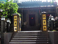
| Yeung Hau Temple | Po Chue Tam, Tai O Tai O Tai O is a fishing town, partly located on an island of the same name, on the western side of Lantau Island in Hong Kong.-Geography:On the main part of Lantau Island, a river splits to the north and west and at this fork lies the island referred to as Tai O. Two pedestrian bridges cross the river... , Lantau Island |
http://www.ctc.org.hk/en/directcontrol/temple19.asp Built in 1699. | 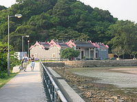 |
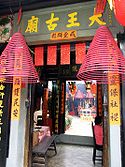
| Yuk Hui Temple Yuk Hui Temple Yuk Hui Temple also known as Pak Tai Temple , is a taoist temple located on the island of Cheung Chau, Hong Kong. The temple address is Pak She Street, Tung Wan, Cheung Chau.- Introduction :... |
Pak She Street, Tung Wan, Cheung Chau Cheung Chau Cheung Chau is a small island 10 km southwest of Hong Kong Island, is nicknamed as the 'dumbbell island' for its shape. It has been inhabited for longer than most other places in the territory of Hong Kong, with a population of about 23,000 up to 2006... |
http://www.gohk.gov.hk/eng/welcome/isl/isl_info_isl3.html http://www.ctc.org.hk/en/directcontrol/temple23.asp Commonly referred to as Pak Tai Pak Tai Pak Tai is a Taoist god of the North. Many Chinese celebrate his birthday on April 21.-Background:Pak Tai, also named Yuen Tin Sheung Tai , was a prince of the Shang Dynasty. During the fall of the Shang Dynasty, the Demon King ravaged the world... Temple |
 |
Kwun Tong DistrictKwun Tong DistrictKwun Tong is one of the 18 districts of Hong Kong. It is located in Kowloon. It had a population of 562,427 in 2001. The district has the third highest population while the income is below average....
| Name | Location | Notes/References | Photographs |
|---|---|---|---|
| Ex. Royal Air Force Station (Kai Tak), Headquarters Building | No. 50 Kwun Tong Road Kwun Tong Road Kwun Tong Road is a major road in Kwun Tong of New Kowloon in Hong Kong. It starts at the junction with Prince Edward Road East, Clear Water Bay Road and Lung Cheung Road in Ngau Chi Wan... , Kowloon Bay Kowloon Bay Kowloon Bay is a bay located at the east of the Kowloon Peninsula and north of Hong Kong Island in Hong Kong. It is the eastern portion of Victoria Harbour, between Hung Hom and Lei Yue Mun... , Kowloon Kowloon Kowloon is an urban area in Hong Kong comprising the Kowloon Peninsula and New Kowloon. It is bordered by the Lei Yue Mun strait in the east, Mei Foo Sun Chuen and Stonecutter's Island in the west, Tate's Cairn and Lion Rock in the north, and Victoria Harbour in the south. It had a population of... |
Kai Tak Vietnamese Refugee Camp from 1979 to 1981. Used for detaining Vietnamese refugees Vietnamese people in Hong Kong Many of the Vietnamese people in Hong Kong immigrated as a result of the war and persecution in Vietnam since the mid-1970s. There is however also small but growing community of diaspora vietnamese being sent to Hong Kong forming an expatriate community, from countries far afield like Australia,... until 1997. Houses the Caritas Caritas Hong Kong Caritas Hong Kong is a charitable organisation of Caritas founded by the Catholic Diocese of Hong Kong in July 1953. It started with relief and rehabilitation services to the poor and the distressed after the Second World War. It nowaday expands to involve social service, education service,... Family Crisis Support Centre since 2002. |
|
| Ex. Royal Air Force Station (Kai Tak), Officers' Quarters Compound RAF Officers' Mess | No. 51 Kwun Tong Road Kwun Tong Road Kwun Tong Road is a major road in Kwun Tong of New Kowloon in Hong Kong. It starts at the junction with Prince Edward Road East, Clear Water Bay Road and Lung Cheung Road in Ngau Chi Wan... , Kowloon Bay, Kowloon |
Housed the Police Detective Training School until 2001. Now houses the Academy of Visual Arts, Hong Kong Baptist University Hong Kong Baptist University Hong Kong Baptist University is a publicly-funded tertiary institution with a Christian education heritage. It is the sole surviving institution of 13 major Christian universities that once operated on the Chinese mainland,... . |
|
| Ex. Royal Air Force Station (Kai Tak), Officers' Quarters Compound Annex Block No. 2 | No. 51 Kwun Tong Road Kwun Tong Road Kwun Tong Road is a major road in Kwun Tong of New Kowloon in Hong Kong. It starts at the junction with Prince Edward Road East, Clear Water Bay Road and Lung Cheung Road in Ngau Chi Wan... , Kowloon Bay, Kowloon |
Same as above. | |
North DistrictNorth District, Hong KongNorth District is the northernmost district of the 18 districts of Hong Kong. It is located in the northwestern part of the New Territories. The new town of Fanling-Sheung Shui is within this district. It had a population of 298,657 in 2001. The district has the second lowest population density.It...
| Name | Location | Notes/References | Photographs |
|---|---|---|---|
| Earth God Shrine of Kam Tsin Tsuen | Kam Tsin Tsuen, Sheung Shui Sheung Shui Sheung Shui is an area in New Territories, Hong Kong. Sheung Shui Town, a part of this area, is part of the Fanling-Sheung Shui New Town in the North District of Hong Kong. Fanling Town is to its southeast.-History:... , New territories New Territories New Territories is one of the three main regions of Hong Kong, alongside Hong Kong Island and the Kowloon Peninsula. It makes up 86.2% of Hong Kong's territory. Historically, it is the region described in The Convention for the Extension of Hong Kong Territory... |
||
| Hip Tin Temple | Shan Tsui Tsuen, Sha Tau Kok Sha Tau Kok Sha Tau Kok or Shataukok or Sathewkok is a town in the northeastern corner of Hong Kong. Located on the border with mainland China, there is another town of same Chinese name, Shatoujiao, romanized using Hanyu Pinyin, across the Sham Chun River-defined border in Shenzhen of mainland... , New territories |
||
| Pang Ancestral Hall | Fanling Wai Fanling Wai Fanling Wai is a village in Fanling, North District, Hong Kong, built by the Pang Clan. It is composed of a walled village and its extensions: Pak Wai , Ching Wai or Chung Wai - the walled village, and Nam Wai .-History:Fanling Wai is the centre of the Pang Clan who arrived in Hong Kong late in... , Fanling Fanling Fanling , also known as Fan Ling and Fan Leng, is an area in the New Territories of Hong Kong. Administratively, it is part of the North District... , New Territories |
 |
|
| Tin Hau Temple Tin Hau temples in Hong Kong Over 70 temples are dedicated to Tin Hau in Hong Kong. They include:* Tin Hau temple, located at 10 Tin Hau Temple Road, Causeway Bay, east of Victoria Park, in Eastern District, on Hong Kong Island. It is a declared monument. The temple has given its name to the MTR station serving it .* The Tin... |
Sai Ho, Kat O Kat O Kat O or Crooked Island is an island of Hong Kong located in the north-east of the territory. Administratively, it is part of North District.-Geography:... |
||
Sai Kung DistrictSai Kung DistrictSai Kung District is the second largest district in Hong Kong in terms of area. It comprises the southern half of Sai Kung Peninsula and Clear Water Bay Peninsula in the New Territories plus a strip to the east of Kowloon. The administrative centre is Sai Kung Town but the district's population is...
| Name | Location | Notes/References | Photographs |
|---|---|---|---|
| Ham Tin Tsuen | Tai Long | ||
| Tai Long Tsuen | Tai Long | ||
| Tin Hau Temple, Joss House Bay Tin Hau Temple, Joss House Bay The Tin Hau Temple in Joss House Bay , sometimes referred to as Tai Miu is Hong Kong's oldest and largest Tin Hau Temple... |
Fat Tong Mun (Joss House Bay Joss House Bay Joss House Bay, also known as Tai Miu Wan indigenously, is near the south end of Clear Water Bay Peninsula in Hong Kong.... ) |
http://www.ctc.org.hk/en/directcontrol/temple20.asp http://www.travelinsaikung.org.hk/english/land/tin_hau_temple.shtml | 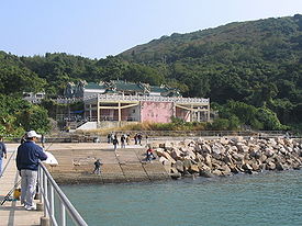 |
Sha Tin DistrictSha Tin DistrictSha Tin District is one of the 18 districts of Hong Kong. One of the 9 districts located in the New Territories, it covers the areas of Sha Tin, Tai Wai, Ma On Shan, Fo Tan, Siu Lek Yuen and Ma Liu Shui . The district has the highest population...
| Name | Location | Notes/References | Photographs |
|---|---|---|---|
| Shek Lei Pui Reception Reservoir Dam | |||
| Shek Lei Pui Reception Reservoir Valve House | |||
| Shing Mun (Jubilee) Reservoir Shing Mun Reservoir Shing Mun Reservoir is a reservoir in Hong Kong. It is located in Shing Mun, the area between Tsuen Wan and Sha Tin, in the New Territories.-History:Several hundreds years ago, the area around the reservoir was a dense forest with very few inhabitants... Lower Reservoir Bellmouth Overflow |
 |
||
| Shing Mun (Jubilee) Reservoir Lower Reservoir Pineapple Pass Dam |  |
||
| Shing Mun (Jubilee) Reservoir Lower Reservoir Steel Bridge | |||
| Shing Mun (Jubilee) Reservoir Lower Reservoir Weir | |||
| Shing Mun (Jubilee) Reservoir Upper Reservoir Gorge Dam |  |
||
| Shing Mun (Jubilee) Reservoir Upper Reservoir Valve Tower |  |
||
| Shing Mun (Jubilee) Reservoir Upper Reservoir Bellmouth Overflow |  |
||
| Shing Mun (Jubilee) Reservoir Lower Reservoir Valve Tower | |
||
| Shing Mun (Jubilee) Reservoir Lower Reservoir Gate Shaft | |||
| Shing Mun (Jubilee) Reservoir Lower Reservoir Supply Basin | |||
| Shing Mun (Jubilee) Reservoir Upper Reservoir Steel Bridge | |
||
| Tsang Tai Uk Tsang Tai Uk Tsang Tai Uk , also known as Shan Ha Wai , is a Hakka walled village in Hong Kong, and one of the best preserved... |
 |
||
Sham Shui Po DistrictSham Shui Po DistrictSham Shui Po District is one of 18 districts of Hong Kong. It covers the Shek Kip Mei, Sham Shui Po, Cheung Sha Wan, Lai Chi Kok and Yau Yat Chuen areas of New Kowloon, and Stonecutter's Island of Kowloon...
| Name | Location | Notes/References | Photographs |
|---|---|---|---|
| Block 41 (Mei Ho House) | Shek Kip Mei Estate Shek Kip Mei Estate Shek Kip Mei Estate is the first public housing estate in Hong Kong. It is located in Sham Shui Po and is under the management of the Hong Kong Housing Authority... |
 |
|
| Some buildings/military facilities within the Ngong Shuen Chau Barracks | Stonecutters Island Stonecutters Island Stonecutters Island or Ngong Shuen Chau is a former island in Victoria Harbour, Hong Kong. Following land reclamation, it is now annexed to the Kowloon peninsula.-Fauna:... |
Some buildings/facilities also Grade II and III | |
Southern DistrictSouthern District, Hong KongThe Southern District is one of the 18 districts of Hong Kong. It is located in the southern part of Hong Kong Island. It had a population of 290,240 in 2001. This district has the fourth lowest population of Hong Kong.-Geography:...
| Name | Location | Notes/References | Photographs |
|---|---|---|---|
| Stanley Fort Stanley Fort Stanley Fort is a military position on the south side of Hong Kong Island.The fort, which occupied a site of 128 hectares, at one time served as a garrison for the British Armed Forces in Hong Kong. After the British Army ceased to use it, the area became the Kai Chi Children's Centre and the... , Stanley Battery Gun Emplacement |
|||
| Hung Shing Temple Hung Shing Temple Hung Shing Temples or Tai Wong Temples are temples dedicated to Hung Shing. Hung Shing temples have been widely built in southern China, especially Guangdong province and in Hong Kong.-Existing temples:... |
No. 9 Hung Shing Street, Ap Lei Chau Ap Lei Chau Ap Lei Chau , or Aberdeen Island, is an island of Hong Kong, located south-west of Hong Kong Island, next to Aberdeen Harbour and Aberdeen Channel, with an area of 1.30 km². Administratively, it is part of Southern District. Ap Lei Chau is the third most densely populated island in the world.-... |
http://www.ctc.org.hk/en/directcontrol/temple9.asp |  |
Tai Po DistrictTai Po DistrictTai Po District is one of the 18 districts of Hong Kong. It covers the areas of Tai Po, Tai Po Kau, Ting Kok, Plover Cove and the northern part of Sai Kung Peninsula on both shores of Tolo Channel. It is located in the New Territories...
| Name | Location | Notes/References | Photographs |
|---|---|---|---|
| Tin Hau Temple Tin Hau temples in Hong Kong Over 70 temples are dedicated to Tin Hau in Hong Kong. They include:* Tin Hau temple, located at 10 Tin Hau Temple Road, Causeway Bay, east of Victoria Park, in Eastern District, on Hong Kong Island. It is a declared monument. The temple has given its name to the MTR station serving it .* The Tin... Complex |
Ha Wai, Tap Mun Chau | 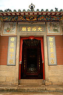 |
|
Tuen Mun DistrictTuen Mun DistrictTuen Mun District is one of the 18 administrative districts of Hong Kong. Its name was previously 'Tsing Shan' and it changed in the 1970s. It is the westernmost continental district of Hong Kong, located about 32 km from the Kowloon Peninsula, 7 km southwest of Yuen Long and 18 km...
| Name | Location | Notes/References | Photographs |
|---|---|---|---|
| Hung Lau | Near Shek Kok Tsui Village, Castle Peak Castle Peak, Hong Kong Castle Peak or Pui To Shan is a 583 m high peak in the western New Territories of Hong Kong.In contrast to its Chinese name, which means green hill, Castle Peak is notorious for its severe loss of vegetation and weathering of its Granite surface.The area to the west of the hill was also named... |
 |
|
| To Ancestral Hall | Tuen Tsz Wai, Lam Tei Lam Tei Lam Tei is an area in the Tuen Mun District, New Territories, Hong Kong. The region lies at the north end of Tuen Mun city. It is highly rural, with Miu Fat Monastery being a landmark of the region. The Sherwood and Botania Villa are two residential estate in Lam Tei.-Transportation:Lam Tei is... |
||
| Tsing Shan Monastery Tsing Shan Monastery The Tsing Shan Monastery is situated at the foot of Castle Peak, Hong Kong. The Monastery is graded as Grade I historic building.-Overview:... |
Castle Peak Castle Peak, Hong Kong Castle Peak or Pui To Shan is a 583 m high peak in the western New Territories of Hong Kong.In contrast to its Chinese name, which means green hill, Castle Peak is notorious for its severe loss of vegetation and weathering of its Granite surface.The area to the west of the hill was also named... |
 |
|
Wan Chai DistrictWan Chai DistrictThe Wan Chai District is one of the 18 districts of Hong Kong, located in the north of Hong Kong island. It had a population of 167,146 in 2001. The district has the second most educated residents with the highest income, the second lowest population and the third oldest residents, and is also the...
| Name | Location | Notes/References | Photographs |
|---|---|---|---|
| Nam Koo Terrace Nam Koo Terrace Nam Koo Terrace is a Grade I Historic Building located at No. 55 Ship Street, Wan Chai, Hong Kong, popularly known as "The Wan Chai Haunted House"... |
No. 55 Ship Street Ship Street, Hong Kong Ship Street is a street in Wan Chai, Hong Kong. It starts from Johnston Road, crosses Queen's Road East and goes uphill southward and reaches Kennedy Road. Part of the street is ladders and much of the century old buildings are abandoned. Locals often refer to these buildings as the "Ghost... |
||
| Blue House Blue House (Hong Kong) Blue House refers to a 4-storey balcony-type tenement block located at 72-74A Stone Nullah Lane, Wan Chai. It is named for the brilliant blue colour painted on its external walls. It is one of the few remaining examples of Tong Lau of the balcony type in Hong Kong... |
No. 72, 72a, 74, 74A Stone Nullah Lane | considered as 4 historic buildings |  |
| Hung Shing Temple Hung Shing Temple, Wan Chai The Hung Shing Temple in Wanchai, Hong Kong is one of several temples dedicated to Hung Shing in the territory.-Location:The temple is located at located at Nos. 129-131 Queen's Road East, Wan Chai. Tai Wong Street West and Tai Wong Street East intersect with Queen's Road East across the street... |
No. 129-131 Queen's Road East | http://www.ctc.org.hk/en/indirectcontrol/temple1.asp |  |
| Yuk Hui Temple | No. 2 Lung On Street | http://www.ctc.org.hk/en/directcontrol/temple10.asp Commonly referred to as Pak Tai Pak Tai Pak Tai is a Taoist god of the North. Many Chinese celebrate his birthday on April 21.-Background:Pak Tai, also named Yuen Tin Sheung Tai , was a prince of the Shang Dynasty. During the fall of the Shang Dynasty, the Demon King ravaged the world... Temple |
 |
| Lin Fa Temple | Lin Fa Kung Street West, Tai Hang Tai Hang Tai Hang is an area southeast of Causeway Bay located in the mid-north of Hong Kong Island in Hong Kong. The area is mainly residential.-Geography:... |
http://www.ctc.org.hk/en/directcontrol/temple1.asp |  |
Wong Tai Sin DistrictWong Tai Sin DistrictWong Tai Sin District is one of the 18 districts of Hong Kong, and is the only landlocked district of the city. It is located in Kowloon and has a population of 444,630...
| Name | Location | Notes/References | Photographs |
|---|---|---|---|
| St. Joseph's Home for the Aged (whole site) | Ngau Chi Wan, Kowloon | ||
| Dormitory A, St. Joseph's Home for the Aged | Clear Water Bay Road Clear Water Bay Road Clear Water Bay Road is a major road from a complex interchange in Ngau Chi Wan to a dead end in Clear Water Bay, Sai Kung. It also is a route to Sai Kung Town and Tseung Kwan O via Hang Hau Road and Hiram's Highway respectively... , Ngau Chi Wan Ngau Chi Wan Ngau Chi Wan was a bay beneath Hammer Hill in New Kowloon, Hong Kong. Its geographical coordinates are 22° 20' 0" North, 114° 12' 0" East. It now refers to an area north of Choi Hung Estate.... |
(Red roof building) | |
| Gate House, St. Joseph's Home for the Aged | Ngau Chi Wan, Kowloon | 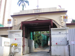 |
|
| Villa, St. Joseph's Home for the Aged | Ngau Chi Wan, Kowloon | (Building on the left) | |
| Hau Wong Hau Wong Hau Wong or Hou Wang is a title that can be translated as "Prince Marquis" or "Holy Marquis". It is not any one person's name. Hau Wong refers usually to Yeung Leung-jit , a loyal and courageous general... Temple |
Cr. of Junction Road Junction Road, Hong Kong Junction Road is a street in Kowloon Tong and Kowloon City, in Kowloon, Hong Kong.... and Tung Tau Tsuen Road |
http://www.ctc.org.hk/en/directcontrol/temple17.asp |  |
Yau Tsim Mong DistrictYau Tsim Mong DistrictYau Tsim Mong District is one of 18 districts of Hong Kong, located on western Kowloon peninsula. It is the core urban area of Kowloon. The district has the third highest population density of all districts...
| Name | Location | Notes/References | Photographs |
|---|---|---|---|
| Lui Seng Chun Lui Seng Chun Lui Seng Chun is a Grade I Historic Building located at 119 Lai Chi Kok Road, in Mong Kok, Hong Kong, at the junction with Tong Mi Road. It is a 4-storey tong-lau that was built in 1931 by Mr. Lui Leung. The architect was Mr. W. H. Bourne.-Historical background:Mr... |
119 Lai Chi Kok Road Lai Chi Kok Road Lai Chi Kok Road is a road in the western part of New Kowloon, Hong Kong. It links Lai Chi Kok to Mong Kok, via Tai Kok Tsui, Sham Shui Po and Cheung Sha Wan. It starts from the junction with Nathan Road near Pioneer Centre in the south and ends near Mei Foo Sun Chuen... , New Kowloon New Kowloon New Kowloon is an area in Kowloon, Hong Kong, bounded in the south by Boundary Street, and in the north by the ranges of the Lion Rock, Beacon Hill, Tate's Cairn and Kowloon Peak... |
 |
|
| Nos. 600-626 Shanghai Street Nos. 600-626 Shanghai Street Nos. 600-626 Shanghai Street, or more specifically Nos. 600, 602, 604, 606, 612, 614, 620, 622, 624 and 626, is a group of ten pre-war shophouses in the Mong Kok section of Shanghai Street, in Hong Kong, that have been listed as Grade I historical buildings for their historical... |
Specifically Nos. 600, 602, 604, 606, 612, 614, 620, 622, 624 and 626 Shanghai Street Shanghai Street Shanghai Street is a 2.3 km long street in the Jordan, Yau Ma Tei and Mong Kok areas of Kowloon, Hong Kong. Completed in 1887 under the name of Station Street , it was once the most prosperous street in Kowloon. It originates from the south at Austin Road, and terminates in the north at Lai... , Mong Kok Mong Kok Mong Kok , less often known as Argyle , is an area in the Yau Tsim Mong District on Kowloon Peninsula, Hong Kong... |
tong-laus |  |
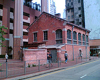
| The Engineer's Office of the Former Pumping Station Engineer's Office of the Former Pumping Station The Engineer's Office of the Former Pumping Station, Water Supplies Department , sometimes called "The Red Brick House" , is located at No. 344 Shanghai Street, in Yau Ma Tei, Hong Kong. It has been classified as a Grade I historical building since 2000 by the Antiquities Advisory Board in view of... , Water Supplies Department |
Shanghai Street Shanghai Street Shanghai Street is a 2.3 km long street in the Jordan, Yau Ma Tei and Mong Kok areas of Kowloon, Hong Kong. Completed in 1887 under the name of Station Street , it was once the most prosperous street in Kowloon. It originates from the south at Austin Road, and terminates in the north at Lai... , Yau Ma Tei Yau Ma Tei Yau Ma Tei, also known as Waterloo , is an area in the Yau Tsim Mong District in the south of the Kowloon Peninsula in Hong Kong.-Name:Yau Ma Tei is a phonetic transliteration of the name 油麻地 in Cantonese... |
 |
|
| Kowloon West II Battery of Whitfield Barracks Whitfield Barracks Whitfield Barracks were barracks in Tsim Sha Tsui, Kowloon, Hong Kong. The area is now the site of Kowloon Park, where several reconverted buildings remain.It was named after Henry Wase Whitfield, the commander of British Army in Hong Kong.-History:... |
Kowloon Park Kowloon Park Kowloon Park is a large public park in Tsim Sha Tsui, Kowloon Peninsula, Hong Kong. It is managed by the Leisure and Cultural Services Department.-History:... , Tsim Sha Tsui Tsim Sha Tsui Tsim Sha Tsui , often abbreviated as TST, is an urbanized area in southern Kowloon, Hong Kong. The area is administratively part of the Yau Tsim Mong District. Tsim Sha Tsui East is a piece of land reclaimed from the Hung Hom Bay now east of Tsim Sha Tsui... |
Now converted into a children's "Discovery Playground" within the park. |  |
| Tung Wah Museum, in Kwong Wah Hospital Kwong Wah Hospital Kwong Wah Hospital is a major hospital in South Kowloon of Hong Kong. It is located at Waterloo Road in Yau Ma Tei.The former Main Hall Building of Kwong Wah Hospital is preserved and houses the Tung Wah Group of Hospitals Museum.-History:... , |
25 Waterloo Road, Yau Ma Tei | 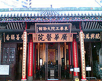 |
|
Yuen Long DistrictYuen Long DistrictYuen Long District , is one of the districts of Hong Kong located in the northwest of the New Territories. It had a population of 449,070 in 2001. The district has the youngest population of Hong Kong and the lowest income in the New Territories.-Geography:...
| Name | Location | Notes/References | Photographs |
|---|---|---|---|
| Kun Ting Study Hall | Hang Mei Tsuen, Ping Shan Ping Shan Ping Shan is an area in the New Territories of Hong Kong. It is located west of Yuen Long Town and Shui Pin Wai, and south of Tin Shui Wai. Administratively, it is part of Yuen Long District.-Geography:... |
http://www.amo.gov.hk/en/trails_pingshan1.php?tid=2 http://www.familles-franco-chinoises.com/hongkong/pingshan/PingShan200908/dscn1148.html http://www.familles-franco-chinoises.com/hongkong/pingshan/PingShan20090913/picture072.jpg Part of the Ping Shan Heritage Trail Ping Shan Heritage Trail Ping Shan Heritage Trail is a heritage trail located in the Ping Shan area of Yuen Long District, in Hong Kong. The trail was inaugurated on 12 December 1993 and was the first of its kind in Hong Kong... . |
|
| Man Ancestral Hall | Fan Tin Tsuen, San Tin San Tin San Tin , or San Tin Heung , is an area located near Lok Ma Chau area in the New Territories and belongs to the Yuen Long District, Hong Kong.... |
||
| Pun Uk | Au Tau Au Tau Au Tau is an area of Yuen Long District, Hong Kong, located directly west of Yuen Long.Pok Oi Hospital is located in Au Tau.Pun Uk, a former mansion and a Grade I Historic Building is located in Au Tau, next to the hospital.... |
http://www.thaiworldview.com/hongkong/newterritories/yuenlong3.htm | 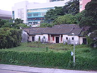 |
| Entrance Hall of Shut Hing Study Hall | Tong Fong Tsuen, Ping Shan Ping Shan Ping Shan is an area in the New Territories of Hong Kong. It is located west of Yuen Long Town and Shui Pin Wai, and south of Tin Shui Wai. Administratively, it is part of Yuen Long District.-Geography:... |
http://www.amo.gov.hk/en/trails_pingshan1.php?tid=12 Part of the Ping Shan Heritage Trail Ping Shan Heritage Trail Ping Shan Heritage Trail is a heritage trail located in the Ping Shan area of Yuen Long District, in Hong Kong. The trail was inaugurated on 12 December 1993 and was the first of its kind in Hong Kong... |
|
| Tang Tsing Lok Ancestral Hall | Pak Wai Tsuen, Kam Tin Kam Tin Kam Tin , or Kam Tin Heung , is an area in the New Territories, Hong Kong. It is north of Tai Mo Shan and east of Yuen Long. It was formerly known as Sham Tin... |
http://www.go2yl.com/history.asp?id=k13&lang=eng | 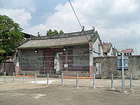 |
| Yu Yuen | Tung Tau Wai, Wang Chau Wang Chau (Yuen Long) Wang Chau is an area of Yuen Long District, Hong Kong, located west of the Shan Pui River.Long Ping Estate is a mixed public/TPS estate in Wang Chau.-Sights:Several monuments are located in Wang Chau, including:... |
Built in 1934 as a summer villa. | 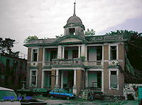 |
| Yuen Kwan Tai Temple | Mong Tseng Wai, Ping Shan Ping Shan Ping Shan is an area in the New Territories of Hong Kong. It is located west of Yuen Long Town and Shui Pin Wai, and south of Tin Shui Wai. Administratively, it is part of Yuen Long District.-Geography:... |
||
| Tin Hau Temple Tin Hau temples in Hong Kong Over 70 temples are dedicated to Tin Hau in Hong Kong. They include:* Tin Hau temple, located at 10 Tin Hau Temple Road, Causeway Bay, east of Victoria Park, in Eastern District, on Hong Kong Island. It is a declared monument. The temple has given its name to the MTR station serving it .* The Tin... |
Off Tai Shu Ha Road, Tai Kei Leng/Nga Yiu Tau, Shap Pat Heung Shap Pat Heung Shap Pat Heung is an area in the New Territories of Hong Kong. Located south of Yuen Long and northwest of Tai Tong, the area occupied the plain north of hills of Tai Lam. Cantonese name Shap Pat Heung means eighteen villages at its beginning. It is later expanded to thirty villages... |
http://www.go2yl.com/history.asp?id=k05&lang=eng Called the "Tai Shu Ha Tin Hau Temple" (大樹下天后廟), it got its name from being a Tin Hau Temple under a tree. |  |
| Ching Shu Hin | Hang Mei Tsuen, Ping Shan Ping Shan Ping Shan is an area in the New Territories of Hong Kong. It is located west of Yuen Long Town and Shui Pin Wai, and south of Tin Shui Wai. Administratively, it is part of Yuen Long District.-Geography:... |
http://www.amo.gov.hk/en/trails_pingshan1.php?tid=3 http://www.familles-franco-chinoises.com/hongkong/pingshan/PingShan200908/dscn1141.html http://www.familles-franco-chinoises.com/hongkong/pingshan/PingShan20090913/picture076.html http://www.familles-franco-chinoises.com/hongkong/pingshan/PingShan200910/dscn1493pingshan20091024.html Part of the Ping Shan Heritage Trail Ping Shan Heritage Trail Ping Shan Heritage Trail is a heritage trail located in the Ping Shan area of Yuen Long District, in Hong Kong. The trail was inaugurated on 12 December 1993 and was the first of its kind in Hong Kong... . |
|
| Tai Wong Temple | No. 26C Cheung Shing Street, Yuen Long Kau Hui Yuen Long Kau Hui Yuen Long Kau Hui is an area in Yuen Long, Yuen Long District, in the western New Territories of Hong Kong.-Geography:Yuen Long Kau Hui is located in the north-east of the present Yuen Long Town. It is sited south of a small hill and directly north of Yuen Long MTR Station. It comprises several... |
 |
|
| Tat Tak Communal Hall | North-west of Sheung Cheung Wai, Ping Shan Ping Shan Ping Shan is an area in the New Territories of Hong Kong. It is located west of Yuen Long Town and Shui Pin Wai, and south of Tin Shui Wai. Administratively, it is part of Yuen Long District.-Geography:... |
In the area covered by the Ping Shan Heritage Trail Ping Shan Heritage Trail Ping Shan Heritage Trail is a heritage trail located in the Ping Shan area of Yuen Long District, in Hong Kong. The trail was inaugurated on 12 December 1993 and was the first of its kind in Hong Kong... . |
|
| Tin Hau Temple Tin Hau temples in Hong Kong Over 70 temples are dedicated to Tin Hau in Hong Kong. They include:* Tin Hau temple, located at 10 Tin Hau Temple Road, Causeway Bay, east of Victoria Park, in Eastern District, on Hong Kong Island. It is a declared monument. The temple has given its name to the MTR station serving it .* The Tin... |
Fung Chi Tsuen, Ping Shan Ping Shan Ping Shan is an area in the New Territories of Hong Kong. It is located west of Yuen Long Town and Shui Pin Wai, and south of Tin Shui Wai. Administratively, it is part of Yuen Long District.-Geography:... |
 |
|
| Yuen Kwan Yi Tai Temple | Yuen Long Kau Hui Yuen Long Kau Hui Yuen Long Kau Hui is an area in Yuen Long, Yuen Long District, in the western New Territories of Hong Kong.-Geography:Yuen Long Kau Hui is located in the north-east of the present Yuen Long Town. It is sited south of a small hill and directly north of Yuen Long MTR Station. It comprises several... |
Commonly known as Pak Tai Temple, it is dedicated to Yuen Tai/Pak Tai Pak Tai Pak Tai is a Taoist god of the North. Many Chinese celebrate his birthday on April 21.-Background:Pak Tai, also named Yuen Tin Sheung Tai , was a prince of the Shang Dynasty. During the fall of the Shang Dynasty, the Demon King ravaged the world... and Kwan Tai. |
 |
See also
- List of buildings and structures in Hong Kong
- Heritage conservation in Hong KongHeritage conservation in Hong KongThis article details the history and status of Heritage conservation in Hong Kong, as well as the role of various stakeholders.An indication of the size of the built heritage in Hong Kong is given by a territory-wide survey conducted by the Antiquities and Monuments Office between 1996 and 2000,...
- Declared monuments of Hong KongDeclared monuments of Hong KongDeclared monuments of Hong Kong are places, structures or buildings legally declared to be "protected". In Hong Kong, declaring a monument requires consulting the Antiquities Advisory Board, the approval of the Chief Executive as well as the publication of the notice in government gazette.As of 12...
- List of Grade II historic buildings in Hong Kong
- List of Grade III historic buildings in Hong Kong
- Heritage Trails in Hong KongHeritage Trails in Hong KongSeveral Heritage Trails have been designed in Hong Kong:Trails designed by the Antiquities and Monuments Office of the Leisure and Cultural Services Department:* Ping Shan Heritage Trail, in Yuen Long District, opened on 12 December 1993...
- History of Hong KongHistory of Hong KongHong Kong began as a coastal island geographically located off the southern coast of China. While pockets of settlements had taken place in the region with archaeological findings dating back thousands of years, regular written records were not made...