

Yuen Long Kau Hui
Encyclopedia
Yuen Long Kau Hui is an area in Yuen Long
, Yuen Long District
, in the western New Territories
of Hong Kong
.
. It is sited south of a small hill and directly north of Yuen Long MTR Station. It comprises several villages, which are part of the Shap Pat Heung
Rural Committee
.. From West to East:
And also:
was not located in the busiest place of present-day Yuen Long, namely Yuen Long Main Road (元朗大馬路), part of Castle Peak Road
. The earliest market in Yuen Long was established and developed in late Ming Dynasty
(1368–1644) south of the main road, in Tai Kiu Tun (大橋墩) near Tai Kei Leng (大旗嶺). In 1669, during the reign of Qing
Emperor Kangxi
, an eigtht year coastal ban
, during which most of the population of present-day Hong Kong had been evacuated, was lifted. The same year, the market was moved north to the area now known as Yuen Long Kau Hui. This was done for political reasons. The Market was set up by Tang Man-wai (鄧文蔚), a 23rd generation member of the Tang Clan
of Kam Tin
. He was a district magistrate of Longyou County
in Zhejiang
Province.. While it is far from the coast today, it was beside the seashore when the market was first built.
Agricultural produce and daily necessities for inhabitants in western New Territories were sold at the market. Farmers, boat people and traders came from as far as the nearby coastal districts of Guangdong
Province. Shop houses, inns, residential houses and temples with street sellers clustered along the streets made it a commercial as well as a cultural centre. Temples were built for worship and to judge disputes. Special market days, xuri (墟日), were scheduled on the 3rd, 6th and 9th days of the three ten-day periods of each lunar month
. The market operated from 6 in the morning until dusk. Two entrance gates, one in the east, Tung Mun (東門), and one in the south, Nam Mun (南門), were locked up after the market hours to guard against theft and robbery. At its peak in the early 20th century, the Hui had around one hundred shops. The market was
managed by the Kwong Yu Tong (光裕堂), a trust of a branch of the Tangs in
Kam Tin.
After the British leased the New Territories
in 1898, they built Castle Peak Road to connect major areas of the New Territories and Kowloon
. The villagers proposed and moved the market town to the main road across the river. Yuen Long San Hui (元朗新墟, lit. ""Yuen Long New Market"), was established in 1915 and after WWII the business of Yuen Long Kau Hui declined and most of the shops closed.
village inhabited by many Punti
families surnamed Ng (吳), Lau (劉), Fan (樊), Tang, Cheng (鄭), Leung (梁), Wong (黃) and Lam
. The Lams settled in the village in 1626 coming from Xixiang (西鄉) of Baoan
, Guangdong Province.
Nam Pin Wai was set up by members of the Tang Clan.
Tung Tau Tsuen (lit. "literally village to the east") is so called because it is located in the east of the old market. It was established in the 17th century by the members of several clans, the Chans
(陳) being the major one, and others being the Loks (駱) and the Lis (李) from Dongguan
. The village was originally called Chan Lok Li Tsuen (陳駱李村). Ss. Peter and Paul Church, located at No. 201 Castle Peak Road
in Yuen Long, was originally built in 1925 in Tung Tau Tsuen. It was relocated and rebuilt on the present Castle Peak Road site in 1958.
Choi Uk Tsuen: see separate article
. Ying Lung Wai was established by a branch of the Kam Tin Tangs, who were originally in Nam Pin Wai but moved to the area to establish the village due to feng shui
reasons.
Tai Wai Tsuen was founded by the Wong clan and the Choi clan around the early 16th century.
Wong Uk Tsuen
Shan Pui Tsuen was founded by Lam Siu-yuen (林兆元), a 13th generation member of the Lam
Clan, who moved from Tai Wai Tsuen some 200 years ago.
Tai Kiu Tsuen (lit. "Village of Big Bridge") was so named because a stone bridge was located at its west. It was established some 400 years ago by four clans: the Chan (陳), the Tang (鄧), the Tse (謝) and the Leung (梁). The Tangs probably came from Ping Shan
and the Chans from Bao'an
of Guangdong Province.
Nam Mun Hau (南門口, lit. "Mouth of the Southern Gate") is a built-up area located at the south of Cheung Shing Street, next to the former southern gate (Nam Mun; 南門). It was at the bank of a branch of the Shan Pui River
, where boats anchored for the market-goers to do trading at the market. Several shops were located there.
and Yeung Hau. Other than for worship, the temple was a venue for solving disputes and discussing market affairs among the villagers. It also once served as a yamen
and the officials lived there.
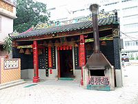
Yuen Kwan Yi Tai Temple (玄關二帝廟), a Grade I Historic Building probably built in 1714 in Cheung Shing Street. Commonly known as Pak Tai Temple, it is dedicated to Yuen Tai/Pak Tai
and Kwan Tai. The temple functions as an ancestral hall and a temple of Sai Pin Wai. Village meetings are also held there.
Kwun Yam Temple (觀音古廟), a Grade II Historic Building in Tung Tau Tsuen. It is believed to have been built in 1712. It is connected with the Tin Hau Temple
in the front and they are considered as one complex. Two statues of Heng and Ha Generals
stand in front of the Kwun Yam altar as her guards. On the left bay is a statue of the God of Wealth (財帛星君) for worship. Yi Shing Temple (二聖宮), in Wong Uk Tsuen, conventionally called Tai Wong Temple. It is mainly for the worship of Hung Shing
and Yeung Hau deities. While its construction year cannot be verified, a renovation was carried out in 1924. It still acts as an alliance temple of the Tung Tau Alliance formed by the seven villages around Tai Wai Tsuen. In the old days, the temple operated a credit society serving the alliance villages.
, and father of Tang Pui-king (鄧佩瓊), the pawnshop was originally located at Lee Yick Street and was moved to the present site in the 1910s. It operated until WWII, when the business of the market declined.
Tung Yick Store (同益棧), Nos. 20 A & 21 Lee Yick Street, a former inn providing accommodation to traveling merchants from other villages. The exact year of its construction is not known, but it is believed that it had existed before 1899.
Entrance Gate of Tai Wai Tsuen, originally built around the early 16th century, reconstructed in 1911. It is one of the places to worship the Earth God.
Lam Ancestral Hall (林氏家祠), at No. 157 Shan Pui Tsuen, was probably built in the 19th century. The building was used as the classrooms of a school for teaching village children in the 1930s-1960s, and as classrooms of a kindergarten in 1967-1968.
Shophouses (tong-lau) of the early 20th century can be found at Nam Mun Hau (Nos. 33-35) and in Lee Yick Street (No. 3a).
Yuen Long
Yuen Long , formerly Un Long, is an area and town located in the northwest of Hong Kong, on the Yuen Long Plain. To its west lie Hung Shui Kiu and Ha Tsuen, to the south Shap Pat Heung and Tai Tong, to the east Au Tau and Kam Tin, and to the north Nam Sang Wai.-Name:The Cantonese name Yuen Long 元朗...
, Yuen Long District
Yuen Long District
Yuen Long District , is one of the districts of Hong Kong located in the northwest of the New Territories. It had a population of 449,070 in 2001. The district has the youngest population of Hong Kong and the lowest income in the New Territories.-Geography:...
, in the western New Territories
New Territories
New Territories is one of the three main regions of Hong Kong, alongside Hong Kong Island and the Kowloon Peninsula. It makes up 86.2% of Hong Kong's territory. Historically, it is the region described in The Convention for the Extension of Hong Kong Territory...
of Hong Kong
Hong Kong
Hong Kong is one of two Special Administrative Regions of the People's Republic of China , the other being Macau. A city-state situated on China's south coast and enclosed by the Pearl River Delta and South China Sea, it is renowned for its expansive skyline and deep natural harbour...
.
Geography
Yuen Long Kau Hui is located in the north-east of the present Yuen Long TownYuen Long Town
Yuen Long Town is located in the district centre of Yuen Long District, New Territories, Hong Kong. It is the heart of Yuen Long and Yuen Long New Town, with a population of around 200,000.- Geography :Yuen Long Town is located in the centre of Yuen Long...
. It is sited south of a small hill and directly north of Yuen Long MTR Station. It comprises several villages, which are part of the Shap Pat Heung
Shap Pat Heung
Shap Pat Heung is an area in the New Territories of Hong Kong. Located south of Yuen Long and northwest of Tai Tong, the area occupied the plain north of hills of Tai Lam. Cantonese name Shap Pat Heung means eighteen villages at its beginning. It is later expanded to thirty villages...
Rural Committee
Rural committee
Rural committee is a body representing the welfare of indigenous residents in the New Territories of Hong Kong. The chairman of each rural committee is the representative in the Heung Yee Kuk, and is ex-officio member of a district council....
.. From West to East:
- Sai Pin Wai (西邊圍), a walled villageWalled villages of Hong KongOnce common throughout China, walled villages can still be found in southern China and Hong Kong. Most of the walled villages in Hong Kong are located in the New Territories...
- Nam Pin Wai (南邊圍), a walled village
- Tung Tau Tsuen (東頭村)
- Tsoi Uk TsuenChoi Uk TsuenChoi Uk Tsuen or Tsoi Uk Tsuen is a village in Yuen Long Kau Hui , in the Yuen Long District of Hong Kong, China.-Features:...
or Choi Uk Tsuen (蔡屋村) - Ying Lung Wai (英龍圍), a walled village
- Tai Wai Tsuen (大圍村), a walled village
- Wong Uk Tsuen (黃屋村)
And also:
- Shan Pui TsuenShan Pui TsuenShan Pui Tsuen is a village in Shap Pat Heung, Yuen Long District, Hong Kong.-Geography:Shan Pui Tsuen is located north of a hill separating it from Yuen Long Kau Hui...
(山背村), located north of the hill. A small boat near the village entrance serves as a ferry across the Shan Pui RiverShan Pui RiverShan Pui River is a river in Yuen Long, New Territories, Hong Kong. It has many tributaries, most of them starting from inside Tai Lam Country Park. It passes six villages and is joined by a few more streams. After flowing through Yuen Long Town, it continues northeast into Yuen Long Industrial...
towards Nam Sang WaiNam Sang WaiNam Sang Wai is a wetland area to the north of Yuen Long, in Hong Kong.-Geography:Nam Sang Wai covers a roughly triangular area. It is bordered by the Shan Pui River in the west, separating it from Yuen Long Industrial Estate, the Kam Tin River in the east and a branch of the Kam Tin River in the...
in the north. - Tai Kiu Tsuen (大橋村), located west of the main group of villages and across the river, directly south of Long Ping MTR Station.
Market
The original Yuen Long TownYuen Long Town
Yuen Long Town is located in the district centre of Yuen Long District, New Territories, Hong Kong. It is the heart of Yuen Long and Yuen Long New Town, with a population of around 200,000.- Geography :Yuen Long Town is located in the centre of Yuen Long...
was not located in the busiest place of present-day Yuen Long, namely Yuen Long Main Road (元朗大馬路), part of Castle Peak Road
Castle Peak Road
Castle Peak Road is the longest road in Hong Kong. It runs from Tai Po Road in Sham Shui Po, Kowloon to the very north of the New Territories, serving south, west and north New Territories, being one of the most distant roads in early Hong Kong.-Name:...
. The earliest market in Yuen Long was established and developed in late Ming Dynasty
Ming Dynasty
The Ming Dynasty, also Empire of the Great Ming, was the ruling dynasty of China from 1368 to 1644, following the collapse of the Mongol-led Yuan Dynasty. The Ming, "one of the greatest eras of orderly government and social stability in human history", was the last dynasty in China ruled by ethnic...
(1368–1644) south of the main road, in Tai Kiu Tun (大橋墩) near Tai Kei Leng (大旗嶺). In 1669, during the reign of Qing
Qing Dynasty
The Qing Dynasty was the last dynasty of China, ruling from 1644 to 1912 with a brief, abortive restoration in 1917. It was preceded by the Ming Dynasty and followed by the Republic of China....
Emperor Kangxi
Kangxi Emperor
The Kangxi Emperor ; Manchu: elhe taifin hūwangdi ; Mongolian: Энх-Амгалан хаан, 4 May 1654 –20 December 1722) was the fourth emperor of the Qing Dynasty, the first to be born on Chinese soil south of the Pass and the second Qing emperor to rule over China proper, from 1661 to 1722.Kangxi's...
, an eigtht year coastal ban
Great Clearance
The Great Clearance or Great Evacuation was ordered in southern China by imperial edicts of the Qing Emperor Kangxi , then under the regency of Oboi, in 1661 and 1662. It required the evacuation of the coastal areas of Guangdong in order to fight the anti-Qing movement, begun by Ming Dynasty...
, during which most of the population of present-day Hong Kong had been evacuated, was lifted. The same year, the market was moved north to the area now known as Yuen Long Kau Hui. This was done for political reasons. The Market was set up by Tang Man-wai (鄧文蔚), a 23rd generation member of the Tang Clan
Tang Clan
The Tang Clan is one of the Great Five Clans of Hong Kong. The others are Man , Hau , Pang and Liu . The Tangs originated from Jishui of Jiangxi province and are considered to be native Hong Kong people, as they were the first immigrants to settle in what is now Hong Kong from what is now...
of Kam Tin
Kam Tin
Kam Tin , or Kam Tin Heung , is an area in the New Territories, Hong Kong. It is north of Tai Mo Shan and east of Yuen Long. It was formerly known as Sham Tin...
. He was a district magistrate of Longyou County
Longyou County
Longyou County is a county of Quzhou City, Zhejiang Province, China....
in Zhejiang
Zhejiang
Zhejiang is an eastern coastal province of the People's Republic of China. The word Zhejiang was the old name of the Qiantang River, which passes through Hangzhou, the provincial capital...
Province.. While it is far from the coast today, it was beside the seashore when the market was first built.
Agricultural produce and daily necessities for inhabitants in western New Territories were sold at the market. Farmers, boat people and traders came from as far as the nearby coastal districts of Guangdong
Guangdong
Guangdong is a province on the South China Sea coast of the People's Republic of China. The province was previously often written with the alternative English name Kwangtung Province...
Province. Shop houses, inns, residential houses and temples with street sellers clustered along the streets made it a commercial as well as a cultural centre. Temples were built for worship and to judge disputes. Special market days, xuri (墟日), were scheduled on the 3rd, 6th and 9th days of the three ten-day periods of each lunar month
Lunar month
In lunar calendars, a lunar month is the time between two identical syzygies . There are many variations. In Middle-Eastern and European traditions, the month starts when the young crescent moon becomes first visible at evening after conjunction with the Sun one or two days before that evening...
. The market operated from 6 in the morning until dusk. Two entrance gates, one in the east, Tung Mun (東門), and one in the south, Nam Mun (南門), were locked up after the market hours to guard against theft and robbery. At its peak in the early 20th century, the Hui had around one hundred shops. The market was
managed by the Kwong Yu Tong (光裕堂), a trust of a branch of the Tangs in
Kam Tin.
After the British leased the New Territories
Convention for the Extension of Hong Kong Territory
The Convention Between Great Britain and China Respecting an Extension of Hong Kong Territory or the Second Convention of Peking was a lease signed between Qing Dynasty and the United Kingdom in 1898.-Background:...
in 1898, they built Castle Peak Road to connect major areas of the New Territories and Kowloon
Kowloon
Kowloon is an urban area in Hong Kong comprising the Kowloon Peninsula and New Kowloon. It is bordered by the Lei Yue Mun strait in the east, Mei Foo Sun Chuen and Stonecutter's Island in the west, Tate's Cairn and Lion Rock in the north, and Victoria Harbour in the south. It had a population of...
. The villagers proposed and moved the market town to the main road across the river. Yuen Long San Hui (元朗新墟, lit. ""Yuen Long New Market"), was established in 1915 and after WWII the business of Yuen Long Kau Hui declined and most of the shops closed.
Villages
Sai Pin Wai is located on the western side of the market. It consists mainly of five rows of houses facing west. The village was set up by the Tangs of Kam Tin probably in the 17th century. It later became a multi-clanChinese clan
A Chinese clan is a patrilineal and patrilocal group of related Chinese people with a common surname sharing a common ancestor and, in many cases, an ancestral home.-Description:...
village inhabited by many Punti
Punti
The Punti, a rough transliteration of the Cantonese term for "original locality," refers to the Cantonese-speaking populations of Guangdong province in southern China...
families surnamed Ng (吳), Lau (劉), Fan (樊), Tang, Cheng (鄭), Leung (梁), Wong (黃) and Lam
Lin (surname)
Lín Lin is the second most common surname in Taiwan at 9% of the population, second only to Chen. In mainland China , Lin is generally less common.-Name origin:...
. The Lams settled in the village in 1626 coming from Xixiang (西鄉) of Baoan
Xin'an County (Bao'an)
Bao'an County , formerly named Xin'an County is a historical region of South China. It is the predecessor of the modern city of Shenzhen and the territory of Hong Kong....
, Guangdong Province.
Nam Pin Wai was set up by members of the Tang Clan.
Tung Tau Tsuen (lit. "literally village to the east") is so called because it is located in the east of the old market. It was established in the 17th century by the members of several clans, the Chans
Chen (surname)
Chén or Chan is one of the most common East Asian family names. It ranks as the 5th most common surname in China, as of 2007 and the most common surname in Singapore and Taiwan . Chen is also the most common family name in Guangdong, Zhejiang, Fujian, Hong Kong...
(陳) being the major one, and others being the Loks (駱) and the Lis (李) from Dongguan
Dongguan
Dongguan is a prefecture-level city in central Guangdong province, People's Republic of China.An important industrial city located in the Pearl River Delta, Dongguan borders the provincial capital of Guangzhou to the north, Huizhou to the northeast, Shenzhen to the south, and the Pearl River to...
. The village was originally called Chan Lok Li Tsuen (陳駱李村). Ss. Peter and Paul Church, located at No. 201 Castle Peak Road
Castle Peak Road
Castle Peak Road is the longest road in Hong Kong. It runs from Tai Po Road in Sham Shui Po, Kowloon to the very north of the New Territories, serving south, west and north New Territories, being one of the most distant roads in early Hong Kong.-Name:...
in Yuen Long, was originally built in 1925 in Tung Tau Tsuen. It was relocated and rebuilt on the present Castle Peak Road site in 1958.
Choi Uk Tsuen: see separate article
Choi Uk Tsuen
Choi Uk Tsuen or Tsoi Uk Tsuen is a village in Yuen Long Kau Hui , in the Yuen Long District of Hong Kong, China.-Features:...
.
Feng shui
Feng shui ' is a Chinese system of geomancy believed to use the laws of both Heaven and Earth to help one improve life by receiving positive qi. The original designation for the discipline is Kan Yu ....
reasons.
Tai Wai Tsuen was founded by the Wong clan and the Choi clan around the early 16th century.
Wong Uk Tsuen
Shan Pui Tsuen was founded by Lam Siu-yuen (林兆元), a 13th generation member of the Lam
Lin (surname)
Lín Lin is the second most common surname in Taiwan at 9% of the population, second only to Chen. In mainland China , Lin is generally less common.-Name origin:...
Clan, who moved from Tai Wai Tsuen some 200 years ago.
Tai Kiu Tsuen (lit. "Village of Big Bridge") was so named because a stone bridge was located at its west. It was established some 400 years ago by four clans: the Chan (陳), the Tang (鄧), the Tse (謝) and the Leung (梁). The Tangs probably came from Ping Shan
Ping Shan
Ping Shan is an area in the New Territories of Hong Kong. It is located west of Yuen Long Town and Shui Pin Wai, and south of Tin Shui Wai. Administratively, it is part of Yuen Long District.-Geography:...
and the Chans from Bao'an
Xin'an County (Bao'an)
Bao'an County , formerly named Xin'an County is a historical region of South China. It is the predecessor of the modern city of Shenzhen and the territory of Hong Kong....
of Guangdong Province.
Villages alliance
The Tung Tau alliance (東頭約) or "Joint Meeting Group of Seven Villages" is an alliance of seven villages: Nam Pin Wai, Tung Tau Tsuen, Tsoi Uk Tsuen, Ying Lung Wai, Shan Pui Tsuen, Wong Uk Tsuen and Tai Wai Tsuen. The Yi Shing Temple in Wong Uk Tsuen (see below) is an alliance temple of the Tung Tau Alliance.Features
Cheung Shing Street (長盛街) was one of the busiest streets of the market. It separates Nam Pin Wai and Sai Pin Wai. Two other notable streets, Lee Yick Street (利益街) and Wine Street (酒街) connect with Cheung Shing Street. The three streets formed the centre of the market.Nam Mun Hau (南門口, lit. "Mouth of the Southern Gate") is a built-up area located at the south of Cheung Shing Street, next to the former southern gate (Nam Mun; 南門). It was at the bank of a branch of the Shan Pui River
Shan Pui River
Shan Pui River is a river in Yuen Long, New Territories, Hong Kong. It has many tributaries, most of them starting from inside Tai Lam Country Park. It passes six villages and is joined by a few more streams. After flowing through Yuen Long Town, it continues northeast into Yuen Long Industrial...
, where boats anchored for the market-goers to do trading at the market. Several shops were located there.
Temples
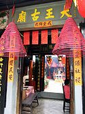
Tai Wong Temple (大王古廟), a Grade I Historic Building, in Cheung Shing Street. Probably built between 1662–1722, it is the main temple of Nam Pin Wai as well as Yuen Long Kau Hui. It was built for the worship of Hung ShingHung Shing
Hung Shing , also known as Hung Shing Ye and Tai Wong , was a government official in the Tang Dynasty named Hung Hei serving Pun Yue in present-day Guangdong, China....
and Yeung Hau. Other than for worship, the temple was a venue for solving disputes and discussing market affairs among the villagers. It also once served as a yamen
Yamen
A yamen is any local bureaucrat's, or mandarin's, office and residence of the Chinese Empire. The term has been widely used in China for centuries, but appeared in English during the Qing Dynasty....
and the officials lived there.
Yuen Kwan Yi Tai Temple (玄關二帝廟), a Grade I Historic Building probably built in 1714 in Cheung Shing Street. Commonly known as Pak Tai Temple, it is dedicated to Yuen Tai/Pak Tai
Pak Tai
Pak Tai is a Taoist god of the North. Many Chinese celebrate his birthday on April 21.-Background:Pak Tai, also named Yuen Tin Sheung Tai , was a prince of the Shang Dynasty. During the fall of the Shang Dynasty, the Demon King ravaged the world...
and Kwan Tai. The temple functions as an ancestral hall and a temple of Sai Pin Wai. Village meetings are also held there.
Kwun Yam Temple (觀音古廟), a Grade II Historic Building in Tung Tau Tsuen. It is believed to have been built in 1712. It is connected with the Tin Hau Temple
Tin Hau temples in Hong Kong
Over 70 temples are dedicated to Tin Hau in Hong Kong. They include:* Tin Hau temple, located at 10 Tin Hau Temple Road, Causeway Bay, east of Victoria Park, in Eastern District, on Hong Kong Island. It is a declared monument. The temple has given its name to the MTR station serving it .* The Tin...
in the front and they are considered as one complex. Two statues of Heng and Ha Generals
Nio
Kongōrikishi or Niō are two wrath-filled and muscular guardians of the Buddha, standing today at the entrance of many Buddhist temples in China, Japan and Korea in the form of frightening wrestler-like statues. They are manifestations of the Bodhisattva ' protector deity and are part of the...
stand in front of the Kwun Yam altar as her guards. On the left bay is a statue of the God of Wealth (財帛星君) for worship.
Hung Shing
Hung Shing , also known as Hung Shing Ye and Tai Wong , was a government official in the Tang Dynasty named Hung Hei serving Pun Yue in present-day Guangdong, China....
and Yeung Hau deities. While its construction year cannot be verified, a renovation was carried out in 1924. It still acts as an alliance temple of the Tung Tau Alliance formed by the seven villages around Tai Wai Tsuen. In the old days, the temple operated a credit society serving the alliance villages.
Other buildings
Chun Yuen Ngat (晉源押), a former pawnshop, at No. 72 Cheung Shing Street. Founded by Tang Lim-ming (鄧廉明) of the Tang ClanTang Clan
The Tang Clan is one of the Great Five Clans of Hong Kong. The others are Man , Hau , Pang and Liu . The Tangs originated from Jishui of Jiangxi province and are considered to be native Hong Kong people, as they were the first immigrants to settle in what is now Hong Kong from what is now...
, and father of Tang Pui-king (鄧佩瓊), the pawnshop was originally located at Lee Yick Street and was moved to the present site in the 1910s. It operated until WWII, when the business of the market declined.
Tung Yick Store (同益棧), Nos. 20 A & 21 Lee Yick Street, a former inn providing accommodation to traveling merchants from other villages. The exact year of its construction is not known, but it is believed that it had existed before 1899.
Entrance Gate of Tai Wai Tsuen, originally built around the early 16th century, reconstructed in 1911. It is one of the places to worship the Earth God.
Lam Ancestral Hall (林氏家祠), at No. 157 Shan Pui Tsuen, was probably built in the 19th century. The building was used as the classrooms of a school for teaching village children in the 1930s-1960s, and as classrooms of a kindergarten in 1967-1968.
Shophouses (tong-lau) of the early 20th century can be found at Nam Mun Hau (Nos. 33-35) and in Lee Yick Street (No. 3a).