

List of European archaeological sites on the National Register of Historic Places in Pennsylvania
Encyclopedia
This is a list of European archaeological sites on the National Register of Historic Places in Pennsylvania.
Historic sites in the United States
qualify to be listed on the National Register of Historic Places
by passing one or more of four different criteria; Criterion D permits the inclusion of proven and potential archaeological site
s. Approximately one hundred different sites in Pennsylvania are listed under this criterion, including both Native American
and European
sites. This list includes all properties in Pennsylvania
that qualify under Criterion D due to the presence of European artifacts
.
Historic sites in the United States
United States
The United States of America is a federal constitutional republic comprising fifty states and a federal district...
qualify to be listed on the National Register of Historic Places
National Register of Historic Places
The National Register of Historic Places is the United States government's official list of districts, sites, buildings, structures, and objects deemed worthy of preservation...
by passing one or more of four different criteria; Criterion D permits the inclusion of proven and potential archaeological site
Archaeological site
An archaeological site is a place in which evidence of past activity is preserved , and which has been, or may be, investigated using the discipline of archaeology and represents a part of the archaeological record.Beyond this, the definition and geographical extent of a 'site' can vary widely,...
s. Approximately one hundred different sites in Pennsylvania are listed under this criterion, including both Native American
Native Americans in the United States
Native Americans in the United States are the indigenous peoples in North America within the boundaries of the present-day continental United States, parts of Alaska, and the island state of Hawaii. They are composed of numerous, distinct tribes, states, and ethnic groups, many of which survive as...
and European
European American
A European American is a citizen or resident of the United States who has origins in any of the original peoples of Europe...
sites. This list includes all properties in Pennsylvania
Pennsylvania
The Commonwealth of Pennsylvania is a U.S. state that is located in the Northeastern and Mid-Atlantic regions of the United States. The state borders Delaware and Maryland to the south, West Virginia to the southwest, Ohio to the west, New York and Ontario, Canada, to the north, and New Jersey to...
that qualify under Criterion D due to the presence of European artifacts
Artifact (archaeology)
An artifact or artefact is "something made or given shape by man, such as a tool or a work of art, esp an object of archaeological interest"...
.
Sites
| Landmark name | Image | Location | County | Comments | |
|---|---|---|---|---|---|
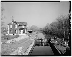
| 1 | Allegheny Aqueduct | Robeson Township: Pennsylvania Route 724 Pennsylvania Route 724 Pennsylvania Route 724 is a road spanning from Sinking Spring, Pennsylvania to Phoenixville, Pennsylvania. 724 travels through the counties of Berks and Chester... and Allegheny Creek at Gibraltar 40°17′10"N 75°53′13"W |
Berks Berks County, Pennsylvania -Demographics:As of the census of 2000, there were 373,638 people, 141,570 households, and 98,532 families residing in the county. The population density was 435 people per square mile . There were 150,222 housing units at an average density of 175 per square mile... |
A section of the Schuylkill Canal Schuylkill Canal Schuylkill Canal is the common, but technically inaccurate, name for the Schuylkill Navigation, a 19th-century commercial waterway in and along the Schuylkill River in the U.S. state of Pennsylvania. The "canal" was actually a system of interconnected man-made canals and slack-water pools in the... |
|
| 2 | Alliance Furnace | Perry Township Perry Township, Fayette County, Pennsylvania Perry Township is a township in Fayette County, Pennsylvania, United States. The population was 2,786 at the 2000 census. The Frazier School District serves the township.... : off Township 568 at Jacob's Creek, northeast of Perryopolis 40°6′45"N 79°43′3"W |
Fayette Fayette County, Pennsylvania Fayette County is a county located in the U.S. state of Pennsylvania. As of the2010 census, the population was 136,606. The county is part of the Pittsburgh Metropolitan Statistical Area.... |
Remnants of a blast furnace Blast furnace A blast furnace is a type of metallurgical furnace used for smelting to produce industrial metals, generally iron.In a blast furnace, fuel and ore and flux are continuously supplied through the top of the furnace, while air is blown into the bottom of the chamber, so that the chemical reactions... complex |
|
| 3 | Barree Forge and Furnace | Porter Township Porter Township, Huntingdon County, Pennsylvania Porter Township is a township in Huntingdon County, Pennsylvania, United States. The population was 1,917 at the 2000 census.-History:The Juniata Iron Works, Barree Forge and Furnace, and Pulpit Rocks are listed on the National Register of Historic Places.... : 2 miles (3.2 km) north of Alexandria along the Juniata River Juniata River The Juniata River is a tributary of the Susquehanna River, approximately long, in central Pennsylvania in the United States. The river is considered scenic along much of its route, having a broad and shallow course passing through several mountain ridges and steeply-lined water gaps... 40°35′18"N 78°6′4"W |
Huntingdon Huntingdon County, Pennsylvania Huntingdon County is a county located in the U.S. state of Pennsylvania. In 2010, its population was 45,913.Huntingdon County was created on September 20, 1787, from part of Bedford County. Its county seat is Huntingdon.-Geography:According to the U.S... |
Remnants of a blast furnace Blast furnace A blast furnace is a type of metallurgical furnace used for smelting to produce industrial metals, generally iron.In a blast furnace, fuel and ore and flux are continuously supplied through the top of the furnace, while air is blown into the bottom of the chamber, so that the chemical reactions... complex |
|
| 4 | Beaver Historic District Beaver, Pennsylvania Beaver is a borough in and the county seat of Beaver County, Pennsylvania, United States, at the confluence of the Beaver and Ohio Rivers. As of the 2000 census, the borough population was 4,775, having dropped from 5,641 in 1940.... |
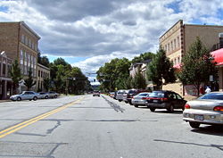 |
Beaver Beaver, Pennsylvania Beaver is a borough in and the county seat of Beaver County, Pennsylvania, United States, at the confluence of the Beaver and Ohio Rivers. As of the 2000 census, the borough population was 4,775, having dropped from 5,641 in 1940.... : roughly bounded by the Cumberland and Pennsylvania Railroad Cumberland and Pennsylvania Railroad The Cumberland and Pennsylvania Railroad was an American railroad which operated in Western Maryland. Primarily a coal hauler, it was owned by the Consolidation Coal Company, and was absorbed into the Western Maryland Railway in 1944.... tracks, Fair Ave., 5th St., 3rd St., and Sassafras Ln. 40°41′41"N 80°18′27"W |
Beaver Beaver County, Pennsylvania -Demographics:As of the census of 2000, there were 181,412 people, 72,576 households, and 50,512 families residing in the county. The population density was 418 people per square mile . There were 77,765 housing units at an average density of 179 per square mile... |
Includes the site of Fort McIntosh Fort McIntosh (Pennsylvania) Fort McIntosh was an early American log frontier fort situated near the confluence of the Ohio River and the Beaver River in what is now Beaver, Pennsylvania.... |
| 5 | Boswell Historic District | Boswell Boswell, Pennsylvania Boswell is a borough in Somerset County, Pennsylvania, United States. It is part of the Johnstown, Pennsylvania Metropolitan Statistical Area. The population was 1,364 at the 2000 census.-Geography:... : roughly bounded by Hower Ave., Atkinson Way, Quemahoning Creek, Main St., and Juniata St. |
Somerset Somerset County, Pennsylvania Somerset County is a county located in the state of Pennsylvania. As of 2010, the population was 77,742. Somerset County was created on April 17, 1795, from part of Bedford County and named for Somerset, United Kingdom. Its county seat is Somerset. It is part of the Johnstown, Pennsylvania,... |
Coal mining company town Company town A company town is a town or city in which much or all real estate, buildings , utilities, hospitals, small businesses such as grocery stores and gas stations, and other necessities or luxuries of life within its borders are owned by a single company... |
|
| 6 | Bradys Bend Iron Company Furnaces | Bradys Bend Township: Pennsylvania Route 68 Pennsylvania Route 68 Pennsylvania Route 68 is a long east–west state highway located in western Pennsylvania in the United States. The western terminus of the route is at the Ohio state line west of Glasgow, where PA 68 continues into Ohio as State Route 39. The eastern terminus is at U.S... in Bradys Bend 40°59′55"N 79°37′34"W |
Armstrong Armstrong County, Pennsylvania Armstrong County is a county located in the U.S. state of Pennsylvania. As of the 2010 census, the population was 68,941. It is located northeast of Pittsburgh and Allegheny County. Armstrong County was added to the Pittsburgh Metropolitan Statistical Area in 2003.The county seat is Kittanning... |
Remnants of a blast furnace Blast furnace A blast furnace is a type of metallurgical furnace used for smelting to produce industrial metals, generally iron.In a blast furnace, fuel and ore and flux are continuously supplied through the top of the furnace, while air is blown into the bottom of the chamber, so that the chemical reactions... complex |
|
| 7 | George Brinton House | Birmingham Township: Pennsylvania Route 100 Pennsylvania Route 100 Pennsylvania Route 100 is a state highway in the U.S. state of Pennsylvania that runs from U.S. Route 202 in West Chester, Pennsylvania to Pennsylvania Route 309 in Pleasant Corners, Pennsylvania.... , 1 mile north of its junction with U.S. Route 1 U.S. Route 1 U.S. Route 1 is a major north–south U.S. Highway that serves the East Coast of the United States. It runs 2,377 miles from Fort Kent, Maine at the Canadian border south to Key West, Florida. U.S. 1 generally parallels Interstate 95, though it is significantly farther west between... , near Chadds Ford 39°52′51"N 75°35′56"W |
Chester Chester County, Pennsylvania -State parks:*French Creek State Park*Marsh Creek State Park*White Clay Creek Preserve-Demographics:As of the 2010 census, the county was 85.5% White, 6.1% Black or African American, 0.2% Native American or Alaskan Native, 3.9% Asian, 0.0% Native Hawaiian, 1.8% were two or more races, and 2.4% were... |
Includes artifacts of the Battle of Brandywine Battle of Brandywine The Battle of Brandywine, also known as the Battle of the Brandywine or the Battle of Brandywine Creek, was fought between the American army of Major General George Washington and the British-Hessian army of General Sir William Howe on September 11, 1777. The British defeated the Americans and... |
|
| 8 | John Brown Tannery Site | Richmond Township Richmond Township, Crawford County, Pennsylvania Richmond Township is a township in Crawford County, Pennsylvania, United States. The population was 1,379 at the 2000 census.-Geography:According to the United States Census Bureau, the township has a total area of 36.7 square miles , of which, 36.6 square miles of it is land and... : 500 feet south of the junction of Pennsylvania Route 77 Pennsylvania Route 77 Pennsylvania Route 77 is a long east–west state highway located in northwest Pennsylvania. The western terminus of the route is at Pennsylvania Route 27 in Meadville... and Lyons Rd. at New Richmond 41°43′8.5"N 79°57′3"W |
Crawford Crawford County, Pennsylvania Crawford County is a county located in the U.S. state of Pennsylvania. As of 2010, the population was 88,765.Crawford County was created on March 12, 1800, from part of Allegheny County and named for Colonel William Crawford... |
Ruins of a tannery Tanning Tanning is the making of leather from the skins of animals which does not easily decompose. Traditionally, tanning used tannin, an acidic chemical compound from which the tanning process draws its name . Coloring may occur during tanning... operated by abolitionist John Brown John Brown (abolitionist) John Brown was an American revolutionary abolitionist, who in the 1850s advocated and practiced armed insurrection as a means to abolish slavery in the United States. He led the Pottawatomie Massacre during which five men were killed, in 1856 in Bleeding Kansas, and made his name in the... |
|
| 9 | Brown-Moore Blacksmith Shop | Luzerne Township: 0.1 mile (0.160934 km) west of Pennsylvania Route 4020 39°58′23"N 79°53′55"W |
Fayette Fayette County, Pennsylvania Fayette County is a county located in the U.S. state of Pennsylvania. As of the2010 census, the population was 136,606. The county is part of the Pittsburgh Metropolitan Statistical Area.... |
Well-preserved early nineteenth-century blacksmith Blacksmith A blacksmith is a person who creates objects from wrought iron or steel by forging the metal; that is, by using tools to hammer, bend, and cut... shop |
|
| 10 | Jeremiah Burns Farm | Washington Township Washington Township, Franklin County, Pennsylvania Washington Township is a township in Franklin County, Pennsylvania, United States. The population was 11,559 at the 2000 census.-Geography:According to the United States Census Bureau, the township has a total area of 38.9 square miles , of which, 38.9 square miles of it is land and... : 10988 Fish and Game Rd. 39°45′58.464"N 77°31′47.46"W |
Franklin Franklin County, Pennsylvania As of the census of 2000, there were 129,313 people, 50,633 households, and 36,405 families residing in the county. The population density was 168 people per square mile . There were 53,803 housing units at an average density of 70 per square mile... |
Includes an early sawmill Sawmill A sawmill is a facility where logs are cut into boards.-Sawmill process:A sawmill's basic operation is much like those of hundreds of years ago; a log enters on one end and dimensional lumber exits on the other end.... and log cabin site |
|
| 11 | Cairnbrook Historic District | Shade Township: roughly bounded by the Penn Central railroad tracks, McGregor Ave., Windber Ave., and John St. 40°7′20"N 78°48′59"W |
Somerset Somerset County, Pennsylvania Somerset County is a county located in the state of Pennsylvania. As of 2010, the population was 77,742. Somerset County was created on April 17, 1795, from part of Bedford County and named for Somerset, United Kingdom. Its county seat is Somerset. It is part of the Johnstown, Pennsylvania,... |
Coal mining company town Company town A company town is a town or city in which much or all real estate, buildings , utilities, hospitals, small businesses such as grocery stores and gas stations, and other necessities or luxuries of life within its borders are owned by a single company... |
|
| 12 | Chad House Chad House The Chad House, which was built by John Wyeth, Jr. for John Chad , is located in Chadds Ford, Pennsylvania. The house was built after 1712 and was added to the National Register of Historic Places on March 11, 1971... |
Chadds Ford Township: Pennsylvania Route 100 Pennsylvania Route 100 Pennsylvania Route 100 is a state highway in the U.S. state of Pennsylvania that runs from U.S. Route 202 in West Chester, Pennsylvania to Pennsylvania Route 309 in Pleasant Corners, Pennsylvania.... 39°52′29"N 75°35′31"W |
Delaware Delaware County, Pennsylvania Delaware County is a county located in the U.S. state of Pennsylvania. As of 2010, the population was 558,979, making it Pennsylvania's fifth most populous county, behind Philadelphia, Allegheny, Montgomery, and Bucks counties.... |
Includes artifacts of the Battle of Brandywine Battle of Brandywine The Battle of Brandywine, also known as the Battle of the Brandywine or the Battle of Brandywine Creek, was fought between the American army of Major General George Washington and the British-Hessian army of General Sir William Howe on September 11, 1777. The British defeated the Americans and... |
|
| 13 | Chester Creek Historic District | Thornbury Township Thornbury Township, Delaware County, Pennsylvania Thornbury Township is a township in Delaware County, Pennsylvania, United States. The population was 7,093 at the 2000 census. It is adjacent to, and was once joined with, Thornbury Township, Chester County, Pennsylvania.-Geography:... : north, east, and south of Glen Mills along the western branch of Chester Creek 39°55′23"N 75°29′27"W |
Delaware Delaware County, Pennsylvania Delaware County is a county located in the U.S. state of Pennsylvania. As of 2010, the population was 558,979, making it Pennsylvania's fifth most populous county, behind Philadelphia, Allegheny, Montgomery, and Bucks counties.... |
Includes multiple early industrial sites | |
| 14 | Chickies Historic District | East Donegal and West Hempfield Townships: roughly bounded by the Susquehanna River Susquehanna River The Susquehanna River is a river located in the northeastern United States. At long, it is the longest river on the American east coast that drains into the Atlantic Ocean, and with its watershed it is the 16th largest river in the United States, and the longest river in the continental United... , Chickies Creek, Bank Street, and Long Lane, near Marietta |
Lancaster Lancaster County, Pennsylvania Lancaster County, known as the Garden Spot of America or Pennsylvania Dutch Country, is a county located in the southeastern part of the Commonwealth of Pennsylvania, in the United States. As of 2010 the population was 519,445. Lancaster County forms the Lancaster Metropolitan Statistical Area, the... |
Includes an early mill site | |
| 15 | Codorus Forge and Furnace Historic District | Hellam Township: junction of River Farm and Furnace Rds., southeast of Saginaw 40°3′5"N 76°39′26"W |
York York County, Pennsylvania York County is a county in the U.S. state of Pennsylvania. As of 2010, the population was 434,972. It is in the Susquehanna Valley, a large fertile agricultural region in South Central Pennsylvania.... |
Remnants of a blast furnace Blast furnace A blast furnace is a type of metallurgical furnace used for smelting to produce industrial metals, generally iron.In a blast furnace, fuel and ore and flux are continuously supplied through the top of the furnace, while air is blown into the bottom of the chamber, so that the chemical reactions... complex |
|
| 16 | Crosley-Garrett Mill Workers' Housing, Store and Mill Site | Newtown Township Newtown Township, Delaware County, Pennsylvania Newtown Township is a township in Delaware County, Pennsylvania, United States . Newtown Township is the oldest township in Delaware County. The population was 11,700 as of the 2000 census.-History:... : Paper Mill Rd. and St. David's Rd. 40°1′9"N 75°24′16"W |
Delaware Delaware County, Pennsylvania Delaware County is a county located in the U.S. state of Pennsylvania. As of 2010, the population was 558,979, making it Pennsylvania's fifth most populous county, behind Philadelphia, Allegheny, Montgomery, and Bucks counties.... |
Industrial company town Company town A company town is a town or city in which much or all real estate, buildings , utilities, hospitals, small businesses such as grocery stores and gas stations, and other necessities or luxuries of life within its borders are owned by a single company... |
|
| 17 | Dale Furnace and Forge Historic District | Washington Township Washington Township, Berks County, Pennsylvania Washington Township is a township in eastern Berks County, Pennsylvania, United States. The population was 3,354 at the 2000 census.-Geography:... : Forgedale Rd. northwest of Bally 40°25′21"N 75°37′1"W |
Berks Berks County, Pennsylvania -Demographics:As of the census of 2000, there were 373,638 people, 141,570 households, and 98,532 families residing in the county. The population density was 435 people per square mile . There were 150,222 housing units at an average density of 175 per square mile... |
Remnants of a blast furnace Blast furnace A blast furnace is a type of metallurgical furnace used for smelting to produce industrial metals, generally iron.In a blast furnace, fuel and ore and flux are continuously supplied through the top of the furnace, while air is blown into the bottom of the chamber, so that the chemical reactions... complex |
|
| 18 | Dreibelbis Mill | Perry Township Perry Township, Berks County, Pennsylvania Perry Township is a township in Berks County, Pennsylvania, United States. The population was 2,517 at the 2000 census.-Geography:According to the United States Census Bureau, the township has a total area of 18.4 square miles , of which, 18.3 square miles of it is land and... : junction of Dreibelbis Mill and Bellevue Rds. 40°30′22"N 75°57′23"W |
Berks Berks County, Pennsylvania -Demographics:As of the census of 2000, there were 373,638 people, 141,570 households, and 98,532 families residing in the county. The population density was 435 people per square mile . There were 150,222 housing units at an average density of 175 per square mile... |
Nineteenth-century gristmill Gristmill The terms gristmill or grist mill can refer either to a building in which grain is ground into flour, or to the grinding mechanism itself.- Early history :... |
|
| 19 | Dykeman's Spring | Shippensburg Shippensburg, Pennsylvania Shippensburg is a borough in Cumberland and Franklin counties in the U.S. state of Pennsylvania. Settled in 1730, Shippensburg lies in the Cumberland Valley, 41 miles west-southwest of Harrisburg, and is part of the Harrisburg–Carlisle Metropolitan Statistical Area. In 1900, 3,228 people... : Dykeman Rd., 0.25 mile (0.402335 km) east of Pennsylvania Route 696 Pennsylvania Route 696 Pennsylvania Route 696 is an long state highway located in Franklin and Cumberland counties in Pennsylvania. The southern terminus is at PA 997 in Greene Township... 40°2′33"N 77°30′57"W |
Cumberland Cumberland County, Pennsylvania Cumberland County is a county located in the U.S. state of Pennsylvania and is one of three counties comprising the Harrisburg–Carlisle Metropolitan Statistical Area. As of 2010, the population was 235,406.-History:... |
Includes military artifacts from the Civil War American Civil War The American Civil War was a civil war fought in the United States of America. In response to the election of Abraham Lincoln as President of the United States, 11 southern slave states declared their secession from the United States and formed the Confederate States of America ; the other 25... ; also includes a Native American site |
|
| 20 | Etna Furnace Etna Furnace (Williamsburg, Pennsylvania) Etna Furnace, also known as Mount Etna Furnace, Aetna Furnace, and Aetna Iron Works, is a historic iron furnace complex and national historic district located at Catharine Township, Blair County, Pennsylvania. The district includes five contributing buildings, six contributing sites, and two... |
Catharine Township: north of Williamsburg — roughly the area south and east of the bend of the Frankstown Branch Juniata River Frankstown Branch Juniata River The Frankstown Branch Juniata River is a tributary of the Juniata River in Blair County, Pennsylvania, in the United States.The headwater tributaries of the Frankstown Branch rise on the slopes of the Allegheny Front south of Altoona... at Mount Etna 40°31′34"N 78°11′11"W |
Blair Blair County, Pennsylvania -Significant Topographic Features:*Brush Mountain*Logan Valley*Morrison Cove*Tussey Mountain-Demographics:As of the census of 2000, there were 129,144 people, 51,518 households, and 34,877 families residing in the county. The population density was 246 people per square mile . There were 55,061... |
Remnants of a blast furnace Blast furnace A blast furnace is a type of metallurgical furnace used for smelting to produce industrial metals, generally iron.In a blast furnace, fuel and ore and flux are continuously supplied through the top of the furnace, while air is blown into the bottom of the chamber, so that the chemical reactions... complex |
|
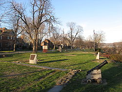
| 21 | Forks of the Ohio Point State Park Point State Park is a Pennsylvania state park on in Downtown Pittsburgh, Allegheny County, Pennsylvania, USA, at the confluence of the Allegheny and Monongahela rivers, forming the Ohio River.... |
 |
Pittsburgh: Point Park 40°26′27"N 80°0′37"W |
Allegheny Allegheny County, Pennsylvania Allegheny County is a county in the southwestern part of the U.S. state of Pennsylvania. As of the 2010 census, the population was 1,223,348; making it the second most populous county in Pennsylvania, following Philadelphia County. The county seat is Pittsburgh... |
Includes the site of Fort Pitt Fort Pitt (Pennsylvania) Fort Pitt was a fort built at the location of Pittsburgh, Allegheny County, Pennsylvania.-French and Indian War:The fort was built from 1759 to 1761 during the French and Indian War , next to the site of former Fort Duquesne, at the confluence the Allegheny River and the Monongahela River... |
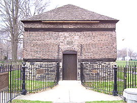
| 22 | Fort Hunter Historic District Fort Hunter Historic District Fort Hunter Historic District is a national historic district located at Fort Hunter, Dauphin County, Pennsylvania. The district includes six contributing buildings, four contributing sites, and one contributing structure. The area has seen continuous settlement since the early 1700s and once... |
Susquehanna Township Susquehanna Township, Dauphin County, Pennsylvania Susquehanna Township is a township in Dauphin County, Pennsylvania, United States. The population was 24,036 at the 2010 census. This represents a 9.8% increase from the 2000 census count of 21,895. Susquehanna Township has the postal ZIP codes 17109 and 17110, which maintain the Harrisburg place... : U.S. Route 22 U.S. Route 22 U.S. Route 22 is a west–east route and is one of the original United States highways of 1926, running from Cincinnati, Ohio, at US 27, US 42, US 127, and US 52 to Newark, New Jersey, at U.S. Route 1/9 near the Newark Liberty International Airport.US 22 also carries the names of the William... 40°20′29"N 76°54′30"W |
Dauphin Dauphin County, Pennsylvania Dauphin County is a county in the U.S. state of Pennsylvania and is one of the three counties comprising the Harrisburg–Carlisle Metropolitan Statistical Area. As of 2010 census, the population was 268,100. The county includes the city of Harrisburg, which has served as the state capital... |
Includes the site of Fort Hunter, built in the 1750s | |
| 23 | Fort McIntosh Site Fort McIntosh (Pennsylvania) Fort McIntosh was an early American log frontier fort situated near the confluence of the Ohio River and the Beaver River in what is now Beaver, Pennsylvania.... |
 |
Beaver Beaver, Pennsylvania Beaver is a borough in and the county seat of Beaver County, Pennsylvania, United States, at the confluence of the Beaver and Ohio Rivers. As of the 2000 census, the borough population was 4,775, having dropped from 5,641 in 1940.... : on a bluff overlooking the Ohio River Ohio River The Ohio River is the largest tributary, by volume, of the Mississippi River. At the confluence, the Ohio is even bigger than the Mississippi and, thus, is hydrologically the main stream of the whole river system, including the Allegheny River further upstream... , along River Rd. between College and Dravo Aves. 40°41′27.35"N 80°18′14.75"W |
Beaver Beaver County, Pennsylvania -Demographics:As of the census of 2000, there were 181,412 people, 72,576 households, and 50,512 families residing in the county. The population density was 418 people per square mile . There were 77,765 housing units at an average density of 179 per square mile... |
Site of the first U.S. Army United States Army The United States Army is the main branch of the United States Armed Forces responsible for land-based military operations. It is the largest and oldest established branch of the U.S. military, and is one of seven U.S. uniformed services... fort north of the Ohio River |
| 24 | Gettysburg National Military Park Gettysburg Battlefield The Gettysburg Battlefield is the area of the July 1–3, 1863, military engagements of the Battle of Gettysburg within and around the borough of Gettysburg, Pennsylvania. Locations of military engagements extend from the 4 acre site of the first shot & at on the west of the borough, to East... |
Cumberland Cumberland Township, Adams County, Pennsylvania Cumberland Township is a township in Adams County, Pennsylvania, United States. The population was 5,718 at the 2000 census.-Geography:According to the United States Census Bureau, the township has a total area of , of which, of it is land and of it is water.-Demographics:As of the census of... , Highland Highland Township, Adams County, Pennsylvania Created in 1863 from parts of Hamiltonban, Cumberland, and Franklin Townships, Highland Township is a township in Adams County, Pennsylvania, United States... , and Straban Townships: Gettysburg National Military Park, near Gettysburg 39°48′43"N 77°14′39"W |
Adams Adams County, Pennsylvania Adams County is a county in the U.S. state of Pennsylvania. As of the 2010 census, the population was 101,407. It was created on January 22, 1800, from part of York County and named in honor of the second President of the United States, John Adams... |
Site of the Battle of Gettysburg Battle of Gettysburg The Battle of Gettysburg , was fought July 1–3, 1863, in and around the town of Gettysburg, Pennsylvania. The battle with the largest number of casualties in the American Civil War, it is often described as the war's turning point. Union Maj. Gen. George Gordon Meade's Army of the Potomac... |
|
| 25 | Geiger Mill | Robeson Township: junction of Mill Rd. and Pennsylvania Route 82 Pennsylvania Route 82 Pennsylvania Route 82 is a long north–south state highway located in southeast Pennsylvania, USA. The northern terminus is at PA 23 in Elverson... in Geiger 40°12′0"N 75°50′15"W |
Berks Berks County, Pennsylvania -Demographics:As of the census of 2000, there were 373,638 people, 141,570 households, and 98,532 families residing in the county. The population density was 435 people per square mile . There were 150,222 housing units at an average density of 175 per square mile... |
Late eighteenth-century gristmill Gristmill The terms gristmill or grist mill can refer either to a building in which grain is ground into flour, or to the grinding mechanism itself.- Early history :... |
|
| 26 | Greenwood Furnace Greenwood Furnace State Park Greenwood Furnace State Park is a Pennsylvania state park in Jackson Township, Huntingdon County, Pennsylvania in the United States. The park is near the historic iron making center of Greenwood Furnace. The park includes the ghost town of Greenwood that grew up around the ironworks, old roads and... |
Jackson Township Jackson Township, Huntingdon County, Pennsylvania Jackson Township is a township in Huntingdon County, Pennsylvania, United States. The population was 882 at the 2000 census. Greenwood Furnace State Park is a Pennsylvania state park in Jackson Township.-Geography:... : Pennsylvania Route 305 Pennsylvania Route 305 Pennsylvania Route 305 is an long state highway located in Huntingdon and Mifflin counties in Pennsylvania. The western terminus is at US 22 in Alexandria. The eastern terminus is at PA 655 in Belleville... in Greenwood Furnace State Park Greenwood Furnace State Park Greenwood Furnace State Park is a Pennsylvania state park in Jackson Township, Huntingdon County, Pennsylvania in the United States. The park is near the historic iron making center of Greenwood Furnace. The park includes the ghost town of Greenwood that grew up around the ironworks, old roads and... , east of McAlevys Fort 40°38′48"N 77°46′41"W |
Huntingdon Huntingdon County, Pennsylvania Huntingdon County is a county located in the U.S. state of Pennsylvania. In 2010, its population was 45,913.Huntingdon County was created on September 20, 1787, from part of Bedford County. Its county seat is Huntingdon.-Geography:According to the U.S... |
Remnants of a blast furnace Blast furnace A blast furnace is a type of metallurgical furnace used for smelting to produce industrial metals, generally iron.In a blast furnace, fuel and ore and flux are continuously supplied through the top of the furnace, while air is blown into the bottom of the chamber, so that the chemical reactions... complex |
|
| 27 | Guldin Mill | Maidencreek Township: off Pennsylvania Route 73 Pennsylvania Route 73 Pennsylvania Route 73 is a 62.51 miles long east–west state highway in southeastern Pennsylvania. It runs from Pennsylvania Route 61 in Leesport to the New Jersey state line on the Tacony-Palmyra Bridge in Philadelphia, where it continues as New Jersey Route 73.Predating the Interstate... southeast of its junction with U.S. Route 222 40°26′8"N 75°52′42"W |
Berks Berks County, Pennsylvania -Demographics:As of the census of 2000, there were 373,638 people, 141,570 households, and 98,532 families residing in the county. The population density was 435 people per square mile . There were 150,222 housing units at an average density of 175 per square mile... |
Early nineteenth-century gristmill Gristmill The terms gristmill or grist mill can refer either to a building in which grain is ground into flour, or to the grinding mechanism itself.- Early history :... |
|
| 28 | Holicong Village Historic District | Buckingham Township Buckingham Township, Bucks County, Pennsylvania Buckingham Township is a township in Bucks County, Pennsylvania, United States. The population was 20,075 at the 2010 census. Buckingham takes its name from Buckingham in Buckinghamshire known as Bucks County in England... : U.S. Route 202 U.S. Route 202 U.S. Route 202 is a highway stretching from Delaware to Maine, also passing through the states of Pennsylvania, New Jersey, New York, Connecticut, Massachusetts, and New Hampshire.... and Holicong Rd. at Holicong 40°20′9"N 75°2′55"W |
Bucks Bucks County, Pennsylvania - Industry and commerce :The boroughs of Bristol and Morrisville were prominent industrial centers along the Northeast Corridor during World War II. Suburban development accelerated in Lower Bucks in the 1950s with the opening of Levittown, Pennsylvania, the second such "Levittown" designed by... |
Eighteenth-century village | |
| 29 | Hower-Slote House | Lewis Township Lewis Township, Northumberland County, Pennsylvania Lewis Township is a township in Northumberland County, Pennsylvania, United States. The population was 1,862 at the 2000 census.-Geography:... : west of Turbotville 41°6′6"N 76°47′45"W |
Northumberland Northumberland County, Pennsylvania There were 38,835 households out of which 27.30% had children under the age of 18 living with them, 52.40% were married couples living together, 9.60% had a female householder with no husband present, and 34.10% were non-families. 30.20% of all households were made up of individuals and 15.50% had... |
Includes part of the site of Fort Freeland, built during the American Revolutionary War American Revolutionary War The American Revolutionary War , the American War of Independence, or simply the Revolutionary War, began as a war between the Kingdom of Great Britain and thirteen British colonies in North America, and ended in a global war between several European great powers.The war was the result of the... |
|
| 30 | Independence National Historical Park Independence National Historical Park Independence National Historical Park is a United States National Historical Park in Philadelphia that preserves several sites associated with the American Revolution and the nation's founding history. Administered by the National Park Service, the park comprises much of the downtown historic... |
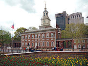 |
Philadelphia: bounded by Walnut, 6th, Chestnut, and 2nd Sts. 39°56′52"N 75°8′53"W |
Philadelphia Philadelphia County, Pennsylvania -History:Tribes of Lenape were the first known occupants in the area which became Philadelphia County. The first European settlers were Swedes and Finns who arrived in 1638. The Netherlands seized the area in 1655, but permanently lost control to England in 1674... |
Includes Independence Hall |
| 31 | Jacobsburg Historic District | Bushkill Township: 3 miles (4.8 km) northeast of Nazareth off Pennsylvania Route 115 Pennsylvania Route 115 Pennsylvania Route 115 is a north–south state highway in eastern Pennsylvania. It stretches from U.S. Route 209 in Brodheadsville to Interstate 81 and Pennsylvania Route 309 near Wilkes-Barre. The road originated as the Sullivan Trail which later became known as the Easton and Wilkes-Barre... 40°46′57"N 75°17′34"W |
Northampton Northampton County, Pennsylvania As of the 2010 census, the county was 86.3% White, 5.0% Black or African American, 0.2% Native American or Alaskan Native, 2.4% Asian, 0.0% Native Hawaiian, 2.2% were two or more races, and 3.8% were some other race. 10.5% of the population were of Hispanic or Latino ancestry.As of the census of... |
Eighteenth-century industrial village | |
| 32 | Nicholas Johnson Mill | Colebrookdale Township: Mill Crest Rd. 40°20′58"N 75°37′12"W |
Berks Berks County, Pennsylvania -Demographics:As of the census of 2000, there were 373,638 people, 141,570 households, and 98,532 families residing in the county. The population density was 435 people per square mile . There were 150,222 housing units at an average density of 175 per square mile... |
Nineteenth-century gristmill Gristmill The terms gristmill or grist mill can refer either to a building in which grain is ground into flour, or to the grinding mechanism itself.- Early history :... |
|
| 33 | Kauffman Mill | Upper Bern Township: junction of Mill and Mill Hill Rds. 40°31′30"N 76°3′47"W |
Berks Berks County, Pennsylvania -Demographics:As of the census of 2000, there were 373,638 people, 141,570 households, and 98,532 families residing in the county. The population density was 435 people per square mile . There were 150,222 housing units at an average density of 175 per square mile... |
Late eighteenth-century gristmill Gristmill The terms gristmill or grist mill can refer either to a building in which grain is ground into flour, or to the grinding mechanism itself.- Early history :... |
|
| 34 | Kise Mill Bridge Historic District | Newberry Township: junction of Kise Mill and Roxberry Rds., east of Lewisberry 40°6′59.5"N 76°48′35.9"W |
York York County, Pennsylvania York County is a county in the U.S. state of Pennsylvania. As of 2010, the population was 434,972. It is in the Susquehanna Valley, a large fertile agricultural region in South Central Pennsylvania.... |
Remnants of an early nineteenth-century industrial complex | |
| 35 | Knabb-Bieber Mill Knabb-Bieber Mill The Knabb-Bieber Mill is located in Stony Creek Mills, Pennsylvania. The mill was built in 1809 and was added to the National Register of Historic Places on November 8, 1990.... |
Oley Township: Bieber Mill Rd. at Monocacy Creek Monocacy Creek Monocacy Creek is a tributary of the Lehigh River in Northampton County, Pennsylvania in the United States.One of only 56 limestone streams in the state of Pennsylvania, the creek's headwaters lie in the slate belt, near the borough of Chapman.... 40°21′33"N 75°48′38"W |
Berks Berks County, Pennsylvania -Demographics:As of the census of 2000, there were 373,638 people, 141,570 households, and 98,532 families residing in the county. The population density was 435 people per square mile . There were 150,222 housing units at an average density of 175 per square mile... |
Early nineteenth-century gristmill Gristmill The terms gristmill or grist mill can refer either to a building in which grain is ground into flour, or to the grinding mechanism itself.- Early history :... |
|
| 36 | Knipe-Johnson Farm | Upper Gwynedd Township: 606 DeKalb Pike 40°13′2"N 75°15′4"W |
Montgomery Montgomery County, Pennsylvania Montgomery County is a county located in the U.S. state of Pennsylvania, in the United States. As of 2010, the population was 799,874, making it the third most populous county in Pennsylvania . The county seat is Norristown.The county was created on September 10, 1784, out of land originally part... |
Includes sites of late eighteenth-century agricultural buildings | |
| 37 | Lehigh Canal: Eastern Section Glendon and Abbott Street Industrial Sites Lehigh Canal The Lehigh Canal was constructed by the Lehigh Coal & Navigation Company to carry anthracite from the upper Lehigh Valley to the urban markets of the northeast, especially Philadelphia... |
 |
Easton Easton, Pennsylvania Easton is a city in Northampton County, Pennsylvania, United States. The population was 26,800 as of the 2010 census. It is the county seat of Northampton County.... : Lehigh River Lehigh River The Lehigh River, a tributary of the Delaware River, is a river located in eastern Pennsylvania, in the United States. Part of the Lehigh, along with a number of its tributaries, is designated a Pennsylvania Scenic River by the state's Department of Conservation and Natural Resources... from Hopeville to its confluence with the Delaware River Delaware River The Delaware River is a major river on the Atlantic coast of the United States.A Dutch expedition led by Henry Hudson in 1609 first mapped the river. The river was christened the South River in the New Netherland colony that followed, in contrast to the North River, as the Hudson River was then... , west of 40°39′24"N 75°17′41"W |
Northampton Northampton County, Pennsylvania As of the 2010 census, the county was 86.3% White, 5.0% Black or African American, 0.2% Native American or Alaskan Native, 2.4% Asian, 0.0% Native Hawaiian, 2.2% were two or more races, and 3.8% were some other race. 10.5% of the population were of Hispanic or Latino ancestry.As of the census of... |
A section of the Lehigh Canal Lehigh Canal The Lehigh Canal was constructed by the Lehigh Coal & Navigation Company to carry anthracite from the upper Lehigh Valley to the urban markets of the northeast, especially Philadelphia... |
| 38 | Legionville Legionville Legionville was the first formal United States military basic training facility, established by Major General Anthony Wayne, in 1792, near present-day Baden, Pennsylvania to train the soldiers of the Legion of the United States.-History:... |
 |
Harmony Township Harmony Township, Beaver County, Pennsylvania Harmony Township is a township and census-designated place in Beaver County, Pennsylvania, United States. The population was 3,373 at the 2000 census.-Geography:Harmony Township is located at .... : between the Ohio River Ohio River The Ohio River is the largest tributary, by volume, of the Mississippi River. At the confluence, the Ohio is even bigger than the Mississippi and, thus, is hydrologically the main stream of the whole river system, including the Allegheny River further upstream... and Duss Ave., north of its intersection with Legionville Rd. and south of its intersection with Anthony Wayne Dr. 40°37′16"N 80°13′42"W |
Beaver Beaver County, Pennsylvania -Demographics:As of the census of 2000, there were 181,412 people, 72,576 households, and 50,512 families residing in the county. The population density was 418 people per square mile . There were 77,765 housing units at an average density of 179 per square mile... |
Site of the first official U.S. Army United States Army The United States Army is the main branch of the United States Armed Forces responsible for land-based military operations. It is the largest and oldest established branch of the U.S. military, and is one of seven U.S. uniformed services... training camp |
| 39 | Locust Grove | Conoy Township: south of Bainbridge off Pennsylvania Route 441 Pennsylvania Route 441 Pennsylvania Route 441 is a long state route in central Pennsylvania and mostly parallels the Susquehanna River. The southern terminus is at Pennsylvania Route 999 in the Manor Township hamlet of Washington Boro... 40°4′44"N 76°39′38"W |
Lancaster Lancaster County, Pennsylvania Lancaster County, known as the Garden Spot of America or Pennsylvania Dutch Country, is a county located in the southeastern part of the Commonwealth of Pennsylvania, in the United States. As of 2010 the population was 519,445. Lancaster County forms the Lancaster Metropolitan Statistical Area, the... |
Late eighteenth-century farmhouse | |
| 40 | Israel and Samuel Lupfer Tannery Site and House Israel and Samuel Lupfer Tannery Site and House Israel and Samuel Lupfer Tannery Site and House, also known as Monterey Tannery, is a historic home and tannery located at Toboyne Township in Perry County, Pennsylvania... |
Jackson Jackson Township, Perry County, Pennsylvania Jackson Township is a township in Perry County, Pennsylvania, United States. The population was 525 at the 2000 census.-Geography:According to the United States Census Bureau, the township has a total area of , all of it land.-Demographics:... and Toboyne Townships: Black Hollow Rd. 40°16′54.4"N 77°32′1.6"W |
Perry Perry County, Pennsylvania As of the census of 2000, there were 43,602 people, 16,695 households, and 12,320 families residing in the county. The population density was 79 people per square mile . There were 18,941 housing units at an average density of 34 per square mile... |
Remnants of a nineteenth-century tannery Tanning Tanning is the making of leather from the skins of animals which does not easily decompose. Traditionally, tanning used tannin, an acidic chemical compound from which the tanning process draws its name . Coloring may occur during tanning... |
|
| 41 | Mill Creek Historic District Mill Creek Historic District (Bryn Mawr and Gladwyne, Pennsylvania) The Mill Creek Historic District near Bryn Mawr and Gladwyne, Pennsylvania is a historic district that was listed on the National Register of Historic Places on December 10, 1980... |
Lower Merion Township: near and east of Bryn Mawr; also roughly bounded by the Schuylkill River Schuylkill River The Schuylkill River is a river in Pennsylvania. It is a designated Pennsylvania Scenic River.The river is about long. Its watershed of about lies entirely within the state of Pennsylvania. The source of its eastern branch is in the Appalachian Mountains at Tuscarora Springs, near Tamaqua in... , Mill Creek, and Righter's Mill, Rose Glen, and Monk's Rds. 40°1′32"N 75°17′8"W |
Montgomery Montgomery County, Pennsylvania Montgomery County is a county located in the U.S. state of Pennsylvania, in the United States. As of 2010, the population was 799,874, making it the third most populous county in Pennsylvania . The county seat is Norristown.The county was created on September 10, 1784, out of land originally part... |
Includes multiple eighteenth-century industrial complexes | |
| 42 | Millmont Farm | Montgomery Township Montgomery Township, Franklin County, Pennsylvania Montgomery Township is a township in Franklin County, Pennsylvania, United States. The population was 4,949 at the 2000 census.-Geography:According to the United States Census Bureau, the township has a total area of 67.1 square miles , of which, 67.1 square miles of it is land and... : east of Mercersburg at the junction of Pennsylvania Routes 16 Pennsylvania Route 16 Pennsylvania Route 16 is a long east–west state route located in southern Pennsylvania, United States. The western terminus of the route is at U.S. Route 522 in McConnellsburg. The eastern terminus is at the Mason-Dixon Line in Liberty Township, where PA 16 continues into Maryland as... and 416 Pennsylvania Route 416 Pennsylvania Route 416 is an long state highway located in Franklin county in Pennsylvania. The southern terminus is at the Maryland state line near Nova. The northern terminus is at US 30 in St. Thomas Township.-Route description:... 39°48′16"N 77°52′24"W |
Franklin Franklin County, Pennsylvania As of the census of 2000, there were 129,313 people, 50,633 households, and 36,405 families residing in the county. The population density was 168 people per square mile . There were 53,803 housing units at an average density of 70 per square mile... |
Includes a late eighteenth-century gristmill Gristmill The terms gristmill or grist mill can refer either to a building in which grain is ground into flour, or to the grinding mechanism itself.- Early history :... |
|
| 43 | Minersville Coke Ovens Minersville Coke Ovens Minersville Coke Ovens is a historic set of coke oven site located at Carbon Township in Huntingdon County, Pennsylvania. The property includes the remains of beehive and Mitchell coke ovens, the pillars and remains of the tipple, the foundation remains of the supply house, engine and power house,... |
Carbon Township: Pennsylvania Route 913 Pennsylvania Route 913 Pennsylvania Route 913 is a long state highway located in Bedford, Huntingdon and Fulton counties in Pennsylvania. The western terminus is at PA 26 in Saxton. The eastern terminus is at PA 655 in Taylor Township.-Bedford County:... , 1 miles (1.6 km) east of Coalmont 40°13′0"N 78°11′3"W |
Huntingdon Huntingdon County, Pennsylvania Huntingdon County is a county located in the U.S. state of Pennsylvania. In 2010, its population was 45,913.Huntingdon County was created on September 20, 1787, from part of Bedford County. Its county seat is Huntingdon.-Geography:According to the U.S... |
A complex of coke Coke (fuel) Coke is the solid carbonaceous material derived from destructive distillation of low-ash, low-sulfur bituminous coal. Cokes from coal are grey, hard, and porous. While coke can be formed naturally, the commonly used form is man-made.- History :... ovens |
|
| 44 | Monroe Furnace Monroe Furnace Monroe Furnace is a national historic district and historic iron furnace located at Barree Township in Huntingdon County, Pennsylvania. It consists of 1 contributing site and 1 contributing structure. They are the remains of the furnace stack, its immediate surroundings, and the visible foundation... |
Barree Township: junction of Pennsylvania Route 26 Pennsylvania Route 26 Pennsylvania Route 26 is a highway in the south-central area of Pennsylvania. Its northern terminus is at Pennsylvania Route 150 northwest of Howard, Pennsylvania; its southern terminus is at the Maryland state line near Barnes Gap in Union Township... and Legislative Route 31076, 6 miles (9.7 km) northwest of McAlevys Fort 40°41′43"N 77°53′41"W |
Huntingdon Huntingdon County, Pennsylvania Huntingdon County is a county located in the U.S. state of Pennsylvania. In 2010, its population was 45,913.Huntingdon County was created on September 20, 1787, from part of Bedford County. Its county seat is Huntingdon.-Geography:According to the U.S... |
Remnants of a blast furnace Blast furnace A blast furnace is a type of metallurgical furnace used for smelting to produce industrial metals, generally iron.In a blast furnace, fuel and ore and flux are continuously supplied through the top of the furnace, while air is blown into the bottom of the chamber, so that the chemical reactions... complex |
|
| 45 | Mount Hope Estate Mount Hope Estate Mount Hope Estate is a National Register of Historic Places-listed property in Manheim Township, Lancaster County, Pennsylvania. The original estate was the center of operations of the Grubb Family Iron Dynasty during the 19th century and included over , a charcoal iron furnace, a grist mill,... |
Penn Penn Township, Lancaster County, Pennsylvania Penn Township is a township in north central Lancaster County, Pennsylvania, United States. The population was 7,312 at the 2000 census.-Geography:According to the United States Census Bureau, the township has a total area of 29.6 mi²... and Rapho Townships: northwest of Manheim on Pennsylvania Route 72 Pennsylvania Route 72 Pennsylvania Route 72 is a long north–south state route located in southeast Pennsylvania. The southern terminus of the route is at U.S. Route 222 and Pennsylvania Route 272 in downtown Lancaster. The northern terminus is at Pennsylvania Route 443 north of Lickdale in Swatara Township.It... ; also roughly along Shearer's Creek, east of Mansion House Rd. and north of the Pennsylvania Turnpike Pennsylvania Turnpike The Pennsylvania Turnpike is a toll highway system operated by the Pennsylvania Turnpike Commission in the Commonwealth of Pennsylvania, United States. The three sections of the turnpike system total . The main section extends from Ohio to New Jersey and is long... 40°13′37"N 76°25′47"W |
Lancaster Lancaster County, Pennsylvania Lancaster County, known as the Garden Spot of America or Pennsylvania Dutch Country, is a county located in the southeastern part of the Commonwealth of Pennsylvania, in the United States. As of 2010 the population was 519,445. Lancaster County forms the Lancaster Metropolitan Statistical Area, the... |
Includes remnants of a blast furnace Blast furnace A blast furnace is a type of metallurgical furnace used for smelting to produce industrial metals, generally iron.In a blast furnace, fuel and ore and flux are continuously supplied through the top of the furnace, while air is blown into the bottom of the chamber, so that the chemical reactions... complex |
|
| 46 | Muddy Creek Forks Historic District | East Hopewell, Fawn Fawn Township, York County, Pennsylvania Fawn Township is a township in York County, Pennsylvania, United States. The population was 3,099 at the 2010 census. It is served by the South Eastern School District which provides a public education.-Geography:... , and Lower Chanceford Townships: junction of Muddy Creek Forks and New Park Rds. at Muddy Creek Forks 39°48′27"N 76°28′31"W |
York York County, Pennsylvania York County is a county in the U.S. state of Pennsylvania. As of 2010, the population was 434,972. It is in the Susquehanna Valley, a large fertile agricultural region in South Central Pennsylvania.... |
Includes the remnants of an eighteenth-century mill complex | |
| 47 | Jacob Nicholas House Jacob Nicholas House Jacob Nicholas House, also known as the Little Stone House Museum, is a historic home located at Easton, Northampton County, Pennsylvania. It was built about 1750, and is a 2 1/2 story, three bay stone building. It has a rear frame clapboard addition built about 1840. It is built into an... |
Easton Easton, Pennsylvania Easton is a city in Northampton County, Pennsylvania, United States. The population was 26,800 as of the 2010 census. It is the county seat of Northampton County.... : 458 Ferry St. 40°41′22"N 75°12′47"W |
Northampton Northampton County, Pennsylvania As of the 2010 census, the county was 86.3% White, 5.0% Black or African American, 0.2% Native American or Alaskan Native, 2.4% Asian, 0.0% Native Hawaiian, 2.2% were two or more races, and 3.8% were some other race. 10.5% of the population were of Hispanic or Latino ancestry.As of the census of... |
One of six buildings in Easton built before the American Revolution American Revolution The American Revolution was the political upheaval during the last half of the 18th century in which thirteen colonies in North America joined together to break free from the British Empire, combining to become the United States of America... |
|
| 48 | North Warwick Historic and Archeological District | Warwick Township Warwick Township, Chester County, Pennsylvania Warwick Township is a township in Chester County, Pennsylvania, United States. The population was 2,507 at the 2010 census.-Geography:According to the United States Census Bureau, the township has a total area of , all of it land.-Demographics:... : Pennsylvania Route 345 Pennsylvania Route 345 Pennsylvania Route 345 is a state highway in the U.S. state of Pennsylvania. The route runs from Pennsylvania Route 82 in West Nantmeal Township, Chester County north to U.S. Route 422 in Birdsboro, Berks County.-Route description:... and Harmonyville, Bethesda, Hopewell, Piersol, Trythall, and Northside Rds. 40°11′18"N 75°46′8"W |
Chester Chester County, Pennsylvania -State parks:*French Creek State Park*Marsh Creek State Park*White Clay Creek Preserve-Demographics:As of the 2010 census, the county was 85.5% White, 6.1% Black or African American, 0.2% Native American or Alaskan Native, 3.9% Asian, 0.0% Native Hawaiian, 1.8% were two or more races, and 2.4% were... |
Includes eighteenth- and nineteenth-century industrial complexes; also includes a Native American site | |
| 49 | Pennsbury Manor Pennsbury Manor Pennsbury Manor, an estate in Falls Township, Bucks County, Pennsylvania, was the American home of William Penn, founder and first Governor of Pennsylvania. The property was placed on the National Register of Historic Places on October 28, 1969.-History:... |
Falls Township Falls Township, Bucks County, Pennsylvania Falls Township is a township in Bucks County, Pennsylvania, United States. The population was 34,300 at the 2010 census. Portions of Fairless Hills and Levittown, Pennsylvania, are located in the township... : on the Delaware River Delaware River The Delaware River is a major river on the Atlantic coast of the United States.A Dutch expedition led by Henry Hudson in 1609 first mapped the river. The river was christened the South River in the New Netherland colony that followed, in contrast to the North River, as the Hudson River was then... south of Bordentown Rd. 40°8′0"N 74°46′12"W |
Bucks Bucks County, Pennsylvania - Industry and commerce :The boroughs of Bristol and Morrisville were prominent industrial centers along the Northeast Corridor during World War II. Suburban development accelerated in Lower Bucks in the 1950s with the opening of Levittown, Pennsylvania, the second such "Levittown" designed by... |
Site of the home of William Penn William Penn William Penn was an English real estate entrepreneur, philosopher, and founder of the Province of Pennsylvania, the English North American colony and the future Commonwealth of Pennsylvania. He was an early champion of democracy and religious freedom, notable for his good relations and successful... |
|
| 50 | Pennsylvania Canal Guard Lock and Feeder Dam, Raystown Branch Pennsylvania Canal Guard Lock and Feeder Dam, Raystown Branch Pennsylvania Canal Guard Lock and Feeder Dam, Raystown Branch, also known as the Raystown Branch Feeder Canal, is a historic canal structure located at Henderson Township in Huntingdon County, Pennsylvania. The property includes the remains of a guard lock and feeder dam... |
Henderson Township Henderson Township, Huntingdon County, Pennsylvania Henderson Township is a township in Huntingdon County, Pennsylvania, United States. The population was 972 at the 2000 census. The township includes the village of Ardenheim.-History:... : 2.5 miles (4 km) east of Huntingdon, south of U.S. Route 22 U.S. Route 22 U.S. Route 22 is a west–east route and is one of the original United States highways of 1926, running from Cincinnati, Ohio, at US 27, US 42, US 127, and US 52 to Newark, New Jersey, at U.S. Route 1/9 near the Newark Liberty International Airport.US 22 also carries the names of the William... on the Juniata River Juniata River The Juniata River is a tributary of the Susquehanna River, approximately long, in central Pennsylvania in the United States. The river is considered scenic along much of its route, having a broad and shallow course passing through several mountain ridges and steeply-lined water gaps... 40°26′59"N 77°58′9"W |
Huntingdon Huntingdon County, Pennsylvania Huntingdon County is a county located in the U.S. state of Pennsylvania. In 2010, its population was 45,913.Huntingdon County was created on September 20, 1787, from part of Bedford County. Its county seat is Huntingdon.-Geography:According to the U.S... |
A section of the Pennsylvania Canal Pennsylvania Canal Pennsylvania Canal refers generally to a complex system of canals, dams, locks, tow paths, aqueducts, and other infrastructure including, in some cases, railroads in Pennsylvania... |
|
| 51 | The Printzhof The Printzhof The Printzhof, located in Governor Printz Park in Essington, Pennsylvania, was the home of Johan Björnsson Printz, governor of New Sweden.... |
 |
Tinicum Township Tinicum Township, Delaware County, Pennsylvania Tinicum Township, more popularly known as "Tinicum Island" or "The Island", a census-designated place and township in Delaware County, Pennsylvania, United States. The population was 4,353 at the 2000 census. Included within the township's boundaries are the communities of Essington and Lester... : Taylor Ave. and 2nd St. in Essington 39°51′40"N 75°18′11"W |
Delaware Delaware County, Pennsylvania Delaware County is a county located in the U.S. state of Pennsylvania. As of 2010, the population was 558,979, making it Pennsylvania's fifth most populous county, behind Philadelphia, Allegheny, Montgomery, and Bucks counties.... |
Site of a leading building of New Sweden New Sweden New Sweden was a Swedish colony along the Delaware River on the Mid-Atlantic coast of North America from 1638 to 1655. Fort Christina, now in Wilmington, Delaware, was the first settlement. New Sweden included parts of the present-day American states of Delaware, New Jersey, and Pennsylvania.... |
| 52 | Rice's Landing Historic District | Rices Landing Rices Landing, Pennsylvania Rices Landing is a borough in Greene County, Pennsylvania, United States. The population was 443 at the 2000 census.-Geography:Rices Landing is located at .... : roughly bounded by the Monongahela River Monongahela River The Monongahela River is a river on the Allegheny Plateau in north-central West Virginia and southwestern Pennsylvania in the United States... and Water, 2nd, Bayard, Carmichael, High, Main, and Ferry, including Pumpkin Run Peak 39°56′57"N 80°0′0"W |
Greene Greene County, Pennsylvania -Demographics:As of the census of 2000, there were 40,672 people, 15,060 households, and 10,587 families residing in the county. The population density was 71 people per square mile . There were 16,678 housing units at an average density of 29 per square mile... |
Includes remains of nineteenth-century industrial buildings | |
| 53 | Ridley Creek State Park Ridley Creek State Park Ridley Creek State Park is a Pennsylvania state park in Edgmont, Middletown and Upper Providence Townships, Delaware County, Pennsylvania in the United States. The park, about north of the county seat of Media, offers many recreational activities, such as hiking, biking, fishing, and picnicking.... |
Edgemont Township: northwest of Media between Pennsylvania Routes 3 Pennsylvania Route 3 Pennsylvania Route 3 is a state highway located in the southeastern portion of Pennsylvania. The route connects West Chester with Philadelphia. The divided highway that comprises much of its route is the West Chester Pike, built as a turnpike by the Philadelphia and West Chester Turnpike Company... and 352 Pennsylvania Route 352 Pennsylvania Route 352 is a north–south route that begins at U.S. Route 13 in Chester and ends at U.S. Route 30 in Malvern. It is known as Middletown Road between Pennsylvania Route 452 and Pennsylvania Route 926, with the route north of Route 926 called Chester Road.- Delaware County :A few... 39°57′13"N 75°26′41"W |
Delaware Delaware County, Pennsylvania Delaware County is a county located in the U.S. state of Pennsylvania. As of 2010, the population was 558,979, making it Pennsylvania's fifth most populous county, behind Philadelphia, Allegheny, Montgomery, and Bucks counties.... |
Comprises multiple former farms as old as the late seventeenth century | |
| 54 | Robertsdale Historic District | Wood Township: roughly bounded by the USGS United States Geological Survey The United States Geological Survey is a scientific agency of the United States government. The scientists of the USGS study the landscape of the United States, its natural resources, and the natural hazards that threaten it. The organization has four major science disciplines, concerning biology,... 1840 contour line and S. Main, Wood, Lincoln, Cliff, and Cherry Sts., in Robertsdale 40°11′1"N 78°6′45"W |
Huntingdon Huntingdon County, Pennsylvania Huntingdon County is a county located in the U.S. state of Pennsylvania. In 2010, its population was 45,913.Huntingdon County was created on September 20, 1787, from part of Bedford County. Its county seat is Huntingdon.-Geography:According to the U.S... |
Coal mining company town Company town A company town is a town or city in which much or all real estate, buildings , utilities, hospitals, small businesses such as grocery stores and gas stations, and other necessities or luxuries of life within its borders are owned by a single company... |
|
| 55 | Robesonia Furnace Historic District | Robesonia Robesonia, Pennsylvania Robesonia is a borough in Berks County, Pennsylvania, United States. The population was 2,061 at the 2010 census. The majority of the area's population resides out of the borough boundaries. Once famous for its iron furnaces , the town was founded in 1855 by Henry P... : Furnace, S. Church, and Freeman Sts. and Mountain and E. Meadow Aves. 40°20′34"N 76°8′26"W |
Berks Berks County, Pennsylvania -Demographics:As of the census of 2000, there were 373,638 people, 141,570 households, and 98,532 families residing in the county. The population density was 435 people per square mile . There were 150,222 housing units at an average density of 175 per square mile... |
Remnants of a blast furnace Blast furnace A blast furnace is a type of metallurgical furnace used for smelting to produce industrial metals, generally iron.In a blast furnace, fuel and ore and flux are continuously supplied through the top of the furnace, while air is blown into the bottom of the chamber, so that the chemical reactions... complex |
|
| 56 | Rock Hill Farm | Montgomery Township Montgomery Township, Franklin County, Pennsylvania Montgomery Township is a township in Franklin County, Pennsylvania, United States. The population was 4,949 at the 2000 census.-Geography:According to the United States Census Bureau, the township has a total area of 67.1 square miles , of which, 67.1 square miles of it is land and... : 12995 and 12755 Bain Rd. near Mercersburg 39°45′7"N 77°52′8"W |
Franklin Franklin County, Pennsylvania As of the census of 2000, there were 129,313 people, 50,633 households, and 36,405 families residing in the county. The population density was 168 people per square mile . There were 53,803 housing units at an average density of 70 per square mile... |
Includes the ruins of an early seventeenth-century outbuilding | |
| 57 | Saltsburg Historic District |  |
Saltsburg Saltsburg, Pennsylvania Saltsburg is a borough in Indiana County, Pennsylvania, United States. The population was 955 at the 2000 census. The town was based on the construction of salt wells and the canals and railroad tracks that passed through it.-Geography:... : roughly west of Plum and Walnut Alleys to the Kiskiminetas River Kiskiminetas River The Kiskiminetas River is a tributary of the Allegheny River, approximately long, in Western Pennsylvania in the United States... 40°29′2"N 79°27′4"W |
Indiana Indiana County, Pennsylvania -Government and politics:As of November 2008, there are 58,077 registered voters in Indiana County .* Democratic: 26,653 * Republican: 24,159 * Other Parties: 7,265 -County commissioners:*Rodney Ruddock, Chairman, Republican... |
Includes a segment of the Pennsylvania Canal Pennsylvania Canal Pennsylvania Canal refers generally to a complex system of canals, dams, locks, tow paths, aqueducts, and other infrastructure including, in some cases, railroads in Pennsylvania... |
| 58 | Shade Furnace Archaeological District | Shade Township: north of Rockingham above Dark Shade Creek 40°9′11.22"N 78°49′41.88"W |
Somerset Somerset County, Pennsylvania Somerset County is a county located in the state of Pennsylvania. As of 2010, the population was 77,742. Somerset County was created on April 17, 1795, from part of Bedford County and named for Somerset, United Kingdom. Its county seat is Somerset. It is part of the Johnstown, Pennsylvania,... |
Remnants of a blast furnace Blast furnace A blast furnace is a type of metallurgical furnace used for smelting to produce industrial metals, generally iron.In a blast furnace, fuel and ore and flux are continuously supplied through the top of the furnace, while air is blown into the bottom of the chamber, so that the chemical reactions... complex |
|
| 59 | Siegfried's Dale Farm | Maxatawny Township: Siegfried's Rd. 40°32′58"N 75°43′23"W |
Berks Berks County, Pennsylvania -Demographics:As of the census of 2000, there were 373,638 people, 141,570 households, and 98,532 families residing in the county. The population density was 435 people per square mile . There were 150,222 housing units at an average density of 175 per square mile... |
A cluster of eighteenth-century farms | |
| 60 | Slickville Historic District | Salem Township Salem Township, Westmoreland County, Pennsylvania Salem Township is a township in Westmoreland County, Pennsylvania, United States. The population was 6,939 at the 2000 census.-Geography:According to the United States Census Bureau, the township has a total area of 47.8 square miles , of which, 47.1 square miles of it is land and... : roughly bounded by Greenburg and 2nd Aves. and Delmont, Court, Cottage and Fred Sts., in Slickville 40°27′27"N 79°31′23"W |
Westmoreland Westmoreland County, Pennsylvania -Demographics:As of the census of 2000, there were 369,993 people, 149,813 households, and 104,569 families residing in the county. The population density was 361 people per square mile . There were 161,058 housing units at an average density of 157 per square mile... |
Coal mining company town Company town A company town is a town or city in which much or all real estate, buildings , utilities, hospitals, small businesses such as grocery stores and gas stations, and other necessities or luxuries of life within its borders are owned by a single company... |
|
| 61 | Smock Historic District | Franklin Franklin Township, Fayette County, Pennsylvania Franklin Township is a township in Fayette County, Pennsylvania, United States. The population was 2,628 at the 2000 census. The township is served by the Uniontown Area School District.... and Menallen Menallen Township, Fayette County, Pennsylvania Menallen Township is a township in Fayette County, Pennsylvania, United States. It is part of the Pittsburgh Metropolitan Area. The population was 4,644 at the 2000 census... Townships: roughly bounded by Redstone Cemetery, Colonial Mine No. 1, Smock Hill, Colonial Mine No. 2, and Redstone Creek at Smock 39°59′58"N 79°47′5"W |
Fayette Fayette County, Pennsylvania Fayette County is a county located in the U.S. state of Pennsylvania. As of the2010 census, the population was 136,606. The county is part of the Pittsburgh Metropolitan Statistical Area.... |
Coal mining company town Company town A company town is a town or city in which much or all real estate, buildings , utilities, hospitals, small businesses such as grocery stores and gas stations, and other necessities or luxuries of life within its borders are owned by a single company... |
|
| 62 | Sommerheim Park Archaeological District Sommerheim Park Archaeological District The Sommerheim Park Archaeological District includes a group of six archaeological sites west of Erie, Pennsylvania in the United States. The sites are in Sommerheim Park, one of the few undeveloped areas of the Lake Erie shoreline, in Millcreek Township... |
Millcreek Township Millcreek Township, Erie County, Pennsylvania Millcreek Township is a township in Erie County, Pennsylvania, United States. The population was 53,515 at the 2010 census. It is the largest suburb of Erie, Pennsylvania and the sixth-largest municipality in the state; larger than the cities of Altoona and Harrisburg.Millcreek Township is home to... : on bluffs above Sommerheim Dr. and Presque Isle Bay Presque Isle Bay Presque Isle Bay is a natural bay located off the coast of Erie, Pennsylvania, United States. Its embayment is about in length, about across at its widest point, and an average depth of about . The bay is bounded on the north and west by a recurved peninsula that makes up Presque Isle State Park... 42°6′49"N 80°8′42"W |
Erie Erie County, Pennsylvania Erie County is a county located in the U.S. state of Pennsylvania. As of 2010, the population was 280,566. Its county seat is the City of Erie.- Geography :... |
Includes a nineteenth-century trash heap Midden A midden, is an old dump for domestic waste which may consist of animal bone, human excrement, botanical material, vermin, shells, sherds, lithics , and other artifacts and ecofacts associated with past human occupation... , plus multiple Native American sites |
|
| 63 | Upper Roxborough Historic District | Philadelphia and Whitemarsh Township: roughly bounded by Shawmont Ave., Hagy's Mill Rd., and the Schuylkill River Schuylkill River The Schuylkill River is a river in Pennsylvania. It is a designated Pennsylvania Scenic River.The river is about long. Its watershed of about lies entirely within the state of Pennsylvania. The source of its eastern branch is in the Appalachian Mountains at Tuscarora Springs, near Tamaqua in... 40°3′29"N 75°15′6"W |
Montgomery Montgomery County, Pennsylvania Montgomery County is a county located in the U.S. state of Pennsylvania, in the United States. As of 2010, the population was 799,874, making it the third most populous county in Pennsylvania . The county seat is Norristown.The county was created on September 10, 1784, out of land originally part... , Philadelphia Philadelphia County, Pennsylvania -History:Tribes of Lenape were the first known occupants in the area which became Philadelphia County. The first European settlers were Swedes and Finns who arrived in 1638. The Netherlands seized the area in 1655, but permanently lost control to England in 1674... |
Includes the remnants of eighteenth-century industrial complexes | |
| 64 | Robert Wilson House | East Fallowfield Township East Fallowfield Township, Chester County, Pennsylvania East Fallowfield Township is a township in Chester County, Pennsylvania, United States. The population was 7,449 at the 2010 census.-Geography:According to the United States Census Bureau, the township has a total area of , all of it land.... : Strasburg Rd. near Coatesville 39°57′9"N 75°50′32"W |
Chester Chester County, Pennsylvania -State parks:*French Creek State Park*Marsh Creek State Park*White Clay Creek Preserve-Demographics:As of the 2010 census, the county was 85.5% White, 6.1% Black or African American, 0.2% Native American or Alaskan Native, 3.9% Asian, 0.0% Native Hawaiian, 1.8% were two or more races, and 2.4% were... |
Includes an early nineteenth-century tannery Tanning Tanning is the making of leather from the skins of animals which does not easily decompose. Traditionally, tanning used tannin, an acidic chemical compound from which the tanning process draws its name . Coloring may occur during tanning... |
|
| 65 | Yoder Mill | Pike Township Pike Township, Berks County, Pennsylvania Pike Township is a township in Berks County, Pennsylvania, United States. The population was 1,677 at the 2000 census.-Geography:According to the United States Census Bureau, the township has a total area of 13.9 square miles , all of it land. It is drained by the Schuylkill River via the... : Yoder Rd. at Oysterville Creek 40°23′48"N 75°43′14"W |
Berks Berks County, Pennsylvania -Demographics:As of the census of 2000, there were 373,638 people, 141,570 households, and 98,532 families residing in the county. The population density was 435 people per square mile . There were 150,222 housing units at an average density of 175 per square mile... |
Nineteenth-century gristmill Gristmill The terms gristmill or grist mill can refer either to a building in which grain is ground into flour, or to the grinding mechanism itself.- Early history :... |
|
| 66 | York Iron Company Mine | North Codorus Township: north of Green Valley Rd., south of Spring Grove 39°50′29"N 76°48′35"W |
York York County, Pennsylvania York County is a county in the U.S. state of Pennsylvania. As of 2010, the population was 434,972. It is in the Susquehanna Valley, a large fertile agricultural region in South Central Pennsylvania.... |
Remnants of a nineteenth-century iron mine |
See also
- National Register of Historic Places listings in Pennsylvania
- List of Native American archaeological sites on the National Register of Historic Places in Pennsylvania