

Boswell, Pennsylvania
Encyclopedia
Boswell is a borough in Somerset County
, Pennsylvania
, United States
. It is part of the Johnstown, Pennsylvania
Metropolitan Statistical Area. The population was 1,364 at the 2000 census.
.
According to the United States Census Bureau
, the borough has a total area of 0.7 square miles (1.8 km²), all of it land.
of 2000, there were 1,364 people, 608 households, and 370 families residing in the borough. The population density
was 1,852.2 people per square mile (711.7/km²). There were 681 housing units at an average density of 924.7 per square mile (355.3/km²). The racial makeup of the borough was 99.27% White, 0.15% African American, 0.22% Native American, 0.07% Asian, and 0.29% from two or more races. Hispanic or Latino of any race were 0.07% of the population.
There were 608 households out of which 28.1% had children under the age of 18 living with them, 41.9% were married couples
living together, 13.8% had a female householder with no husband present, and 39.1% were non-families. 35.2% of all households were made up of individuals and 17.9% had someone living alone who was 65 years of age or older. The average household size was 2.24 and the average family size was 2.92.
In the borough the population was spread out with 23.8% under the age of 18, 7.9% from 18 to 24, 27.2% from 25 to 44, 21.0% from 45 to 64, and 20.0% who were 65 years of age or older. The median age was 39 years. For every 100 females there were 89.2 males. For every 100 females age 18 and over, there were 86.9 males.
The median income for a household in the borough was $20,875, and the median income for a family was $26,667. Males had a median income of $26,023 versus $18,958 for females. The per capita income
for the borough was $12,036. About 26.4% of families and 29.1% of the population were below the poverty line, including 38.1% of those under age 18 and 14.6% of those age 65 or over.
 Boswell was settled in 1901 and incorporated as a borough on February 22, 1904. The community's founder was Thomas Taylor Boswell, the first president and supervisor of the Merchants Coal Company. Mr. Boswell's company purchased 14000 acres (56.7 km²) of mineral rights under local farmland and laid out 1,600 lots for coal company houses to house the miners for its new deep coal mine
just to the north. Merchants Coal, and the related Orenda Coal, were subsidiaries of Hillman Coal and Coke Company of Pittsburgh, the same firm that built the neighboring town of Jerome, Pennsylvania
.
Merchants Coal attempted to build Boswell to be a notch above surrounding coal company towns in that plans included a central business district, a high school
, and homes constructed from brick, as opposed to the wood used elsewhere. This also helped to prevent the spread of fire, in the event that one would break out. Many of the original brick homes are still standing, with much of their original integrity. A branch of the Baltimore & Ohio railroad served Boswell and its coal mine. At its economic peak shortly after World War II
, Boswell boasted two movie theatres, three department stores, a bank, several jewelry stores, a druggist, two funeral homes, three grocery stores, nearly a dozen restaurants and taverns, a lumber yard, and a weekly newspaper. Earlier, pre-Prohibition, Boswell also boasted its own brewery.
Boswell's streets generally run perpendicular to its avenues, in a grid. Many of the avenues in Boswell are named after coal company officials. For example:
At the same time, the borough's street names can provide a geography lesson, following the flow of water from Boswell to the seas, with two exceptions made for streets in the central business district. Street names from north to south are: Quemahoning, Stonycreek, Center (in place of "Conemaugh" for the Conemaugh River), Main (in place of "Kiskiminetas" for the Kiskiminetas River), Allegheny, Ohio, Mississippi, Mexico (for the Gulf of Mexico
), Atlantic and Pacific.
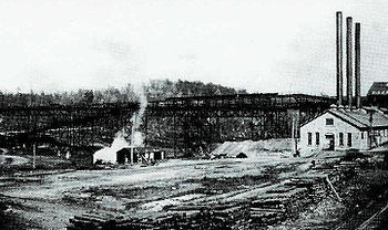
The mine, Orenda Mine #1, extracted high quality, semi-bituminous coal
. A steam engine
hoisted the coal to the surface. The hoist pulled the coal cars up a tipple
that was 1080 feet (329.2 m) long, 92 feet (28 m) high, and 60 feet (18.3 m) wide. In 1920, this was the largest coal tipple in the world. At its prime, 900 men were employed and over 3,000 tons of coal were mined daily. The company was eventually re-named to the United Coal Company and in 1918 it became the Davis Coal Company.
For most of its history, the mine at Boswell operated without union
representation. An early attempt to unionize workers led to an armed riot on January 17, 1904. Seven were wounded and 20 arrested in the melee. A prolonged struggle for unionization, which began at Jerome
and Windber in northern Somerset County in early April, 1922, extended to Boswell on April 17. By April 24, 1922, miners at Acosta, Gray, Ralphton, Randolph and Jenners also joined the strike, which was to last sixteen months. (For a more detailed discussion of the strike, see the wiki for Jerome, Pennsylvania
.)
Mining at Boswell was a problem-plagued effort, according to discussions with local residents from the era. While much archival research remains to be done corroborate these details, it seems apparent that Merchants Coal, and its parent which was eventually known as Hillman Coal & Coke, miscalculated in the siting of Boswell and its mine. Given the size of Merchant's capital outlay—including construction in Boswell of the world's largest tipple, a central business district and a high school—the company planned big things for Boswell. The town of Jerome appears to have been built as a satellite town, soon to be linked with Boswell, both underground in coal production and on the surface in social and cultural life (the right-of-way for a street car line was acquired between Jerome and Boswell, for instance). However, local miners tell of the "Stone Wall," an unexpected and virtually insurmountable underground geological fault hit midway between Jerome and Boswell that prevented the linking of the two mines at a reasonable cost. Evidence of this fault can be seen on the land surface near Route 601 about two miles (3 km) south of Jerome. (Indeed, when mechanized deep-mining resumed in this area for a time in the late 20th century, the entry shaft was sunk adjacent to this fault, presumably so access could be had to the entire field.) It can be speculated that Hillman had planned to use Boswell as its primary processing facility after the link-up, thus the huge tipple. Hillman also likely planned to make Boswell the center of operations and community life (of evidence, the high school). But the two mines never came together; in fact, Boswell's mine proved to be significantly less productive than Jerome's, as shown by documented production figures from 1927, for example. In that year, Boswell produced 204,592 tons of coal, while Jerome produced 816,568 tons, four times as much.
The Boswell mine closed on March 29, 1939 due to the excessive cost of transporting coal to the surface (the Jerome mine worked until 1954). The Boswell tipple was dismantled in 1940, though some of the tipple's abutments still stand today. After the mine closed a slow economic decline set in. However, many businesses survived well into the 1960s and early 1970s. Railroad freight service to Boswell stopped in the early 1970s. Boswell today is primarily a bedroom community.
In 1970, the high school was rechristened as North Star High School
. It is the successor from the earlier Boswell, Jenner Boswell, Jenner-Boswell-Jennerstown, and Forbes High Schools. The high school is approaching its centenary and currently serves the two surrounding townships (Jenner
and Quemahoning
) and three boroughs (Jennerstown, Stoystown and Hooversville) in addition to Boswell residents.
Orenda Park,http://www.boswellpa.com/Orenda%20Park.htm a community forest and picnic area, has been established at the site of the former coal tipple. The park is maintained by the Boswell Area Historical Society. Boswell was designated as a National Historic District in 1994.
into Quemahoning Creek, which flows just north of Boswell. A remediation project was completed in 2005, spearheaded by SCRIP (Stonycreek-Conemaugh River Improvement Project), a non-governmental organization, in collaboration with OSM, the Pennsylvania Department of Environmental Protection, the Southern Alleghenies Conservancy
, Somerset County Conservation District and Reliant Energy
. In addition, the Jenner Rod & Gun Club, a local sportsmen's club, provided significant funds to purchase property for the remediation site.
The discovery of the purple fringeless orchid, an endangered species
, within the remediation site complicated the project. The plants were relocated successfully to unimpacted wetlands immediately adjacent to the remediation site in 2004.
The most recent information showed the system is treating between 1,600 and 2,000 gallons of water per minute, removing approximately 80 tons of iron
a day from the water. About 3,000 trout were stocked successfully into a four-mile (6 km) section of the Creek downstream from Boswell in 2005, the first time the creek supported a fishery along this stretch in almost 100 years.
Somerset County, Pennsylvania
Somerset County is a county located in the state of Pennsylvania. As of 2010, the population was 77,742. Somerset County was created on April 17, 1795, from part of Bedford County and named for Somerset, United Kingdom. Its county seat is Somerset. It is part of the Johnstown, Pennsylvania,...
, Pennsylvania
Pennsylvania
The Commonwealth of Pennsylvania is a U.S. state that is located in the Northeastern and Mid-Atlantic regions of the United States. The state borders Delaware and Maryland to the south, West Virginia to the southwest, Ohio to the west, New York and Ontario, Canada, to the north, and New Jersey to...
, United States
United States
The United States of America is a federal constitutional republic comprising fifty states and a federal district...
. It is part of the Johnstown, Pennsylvania
Johnstown, Pennsylvania
Johnstown is a city in Cambria County, Pennsylvania, United States, west-southwest of Altoona, Pennsylvania and east of Pittsburgh. The population was 20,978 at the 2010 census. It is the principal city of the Johnstown, Pennsylvania, Metropolitan Statistical Area, which includes Cambria County...
Metropolitan Statistical Area. The population was 1,364 at the 2000 census.
Geography
Boswell is located at 40°9′37"N 79°1′40"W (40.160329, -79.027712), about 60 miles (96.6 km) southwest of Altoona, PennsylvaniaAltoona, Pennsylvania
-History:A major railroad town, Altoona was founded by the Pennsylvania Railroad in 1849 as the site for a shop complex. Altoona was incorporated as a borough on February 6, 1854, and as a city under legislation approved on April 3, 1867, and February 8, 1868...
.
According to the United States Census Bureau
United States Census Bureau
The United States Census Bureau is the government agency that is responsible for the United States Census. It also gathers other national demographic and economic data...
, the borough has a total area of 0.7 square miles (1.8 km²), all of it land.
Demographics
As of the censusCensus
A census is the procedure of systematically acquiring and recording information about the members of a given population. It is a regularly occurring and official count of a particular population. The term is used mostly in connection with national population and housing censuses; other common...
of 2000, there were 1,364 people, 608 households, and 370 families residing in the borough. The population density
Population density
Population density is a measurement of population per unit area or unit volume. It is frequently applied to living organisms, and particularly to humans...
was 1,852.2 people per square mile (711.7/km²). There were 681 housing units at an average density of 924.7 per square mile (355.3/km²). The racial makeup of the borough was 99.27% White, 0.15% African American, 0.22% Native American, 0.07% Asian, and 0.29% from two or more races. Hispanic or Latino of any race were 0.07% of the population.
There were 608 households out of which 28.1% had children under the age of 18 living with them, 41.9% were married couples
Marriage
Marriage is a social union or legal contract between people that creates kinship. It is an institution in which interpersonal relationships, usually intimate and sexual, are acknowledged in a variety of ways, depending on the culture or subculture in which it is found...
living together, 13.8% had a female householder with no husband present, and 39.1% were non-families. 35.2% of all households were made up of individuals and 17.9% had someone living alone who was 65 years of age or older. The average household size was 2.24 and the average family size was 2.92.
In the borough the population was spread out with 23.8% under the age of 18, 7.9% from 18 to 24, 27.2% from 25 to 44, 21.0% from 45 to 64, and 20.0% who were 65 years of age or older. The median age was 39 years. For every 100 females there were 89.2 males. For every 100 females age 18 and over, there were 86.9 males.
The median income for a household in the borough was $20,875, and the median income for a family was $26,667. Males had a median income of $26,023 versus $18,958 for females. The per capita income
Per capita income
Per capita income or income per person is a measure of mean income within an economic aggregate, such as a country or city. It is calculated by taking a measure of all sources of income in the aggregate and dividing it by the total population...
for the borough was $12,036. About 26.4% of families and 29.1% of the population were below the poverty line, including 38.1% of those under age 18 and 14.6% of those age 65 or over.
History
Coal mining
The goal of coal mining is to obtain coal from the ground. Coal is valued for its energy content, and since the 1880s has been widely used to generate electricity. Steel and cement industries use coal as a fuel for extraction of iron from iron ore and for cement production. In the United States,...
just to the north. Merchants Coal, and the related Orenda Coal, were subsidiaries of Hillman Coal and Coke Company of Pittsburgh, the same firm that built the neighboring town of Jerome, Pennsylvania
Jerome, Pennsylvania
Jerome is a census-designated place in Somerset County, Pennsylvania, United States. The population was 1,068 at the 2000 census. It is part of the Johnstown, Pennsylvania, Metropolitan Statistical Area...
.
Merchants Coal attempted to build Boswell to be a notch above surrounding coal company towns in that plans included a central business district, a high school
High school
High school is a term used in parts of the English speaking world to describe institutions which provide all or part of secondary education. The term is often incorporated into the name of such institutions....
, and homes constructed from brick, as opposed to the wood used elsewhere. This also helped to prevent the spread of fire, in the event that one would break out. Many of the original brick homes are still standing, with much of their original integrity. A branch of the Baltimore & Ohio railroad served Boswell and its coal mine. At its economic peak shortly after World War II
World War II
World War II, or the Second World War , was a global conflict lasting from 1939 to 1945, involving most of the world's nations—including all of the great powers—eventually forming two opposing military alliances: the Allies and the Axis...
, Boswell boasted two movie theatres, three department stores, a bank, several jewelry stores, a druggist, two funeral homes, three grocery stores, nearly a dozen restaurants and taverns, a lumber yard, and a weekly newspaper. Earlier, pre-Prohibition, Boswell also boasted its own brewery.
Boswell's streets generally run perpendicular to its avenues, in a grid. Many of the avenues in Boswell are named after coal company officials. For example:
- Hower Avenue, after Charles E. Hower, a Surveyor from Johnstown.
- Morris Avenue, after W.H. Morris, a known builder from Johnstown
- Atkinson Way, after W.G. Atkinson, the Vice President of Merchants Coal Company.
At the same time, the borough's street names can provide a geography lesson, following the flow of water from Boswell to the seas, with two exceptions made for streets in the central business district. Street names from north to south are: Quemahoning, Stonycreek, Center (in place of "Conemaugh" for the Conemaugh River), Main (in place of "Kiskiminetas" for the Kiskiminetas River), Allegheny, Ohio, Mississippi, Mexico (for the Gulf of Mexico
Gulf of Mexico
The Gulf of Mexico is a partially landlocked ocean basin largely surrounded by the North American continent and the island of Cuba. It is bounded on the northeast, north and northwest by the Gulf Coast of the United States, on the southwest and south by Mexico, and on the southeast by Cuba. In...
), Atlantic and Pacific.
The mine, Orenda Mine #1, extracted high quality, semi-bituminous coal
Bituminous coal
Bituminous coal or black coal is a relatively soft coal containing a tarlike substance called bitumen. It is of higher quality than lignite coal but of poorer quality than Anthracite...
. A steam engine
Steam engine
A steam engine is a heat engine that performs mechanical work using steam as its working fluid.Steam engines are external combustion engines, where the working fluid is separate from the combustion products. Non-combustion heat sources such as solar power, nuclear power or geothermal energy may be...
hoisted the coal to the surface. The hoist pulled the coal cars up a tipple
Tipple
Tipple can mean:* Coal tipple, a structure used for loading coal into railroad cars* Tipple * Tipple a Welsh surname.* Slang term for alcoholic beverage* Tipple App is an iPhone app designed to help moderate drinking...
that was 1080 feet (329.2 m) long, 92 feet (28 m) high, and 60 feet (18.3 m) wide. In 1920, this was the largest coal tipple in the world. At its prime, 900 men were employed and over 3,000 tons of coal were mined daily. The company was eventually re-named to the United Coal Company and in 1918 it became the Davis Coal Company.
For most of its history, the mine at Boswell operated without union
Trade union
A trade union, trades union or labor union is an organization of workers that have banded together to achieve common goals such as better working conditions. The trade union, through its leadership, bargains with the employer on behalf of union members and negotiates labour contracts with...
representation. An early attempt to unionize workers led to an armed riot on January 17, 1904. Seven were wounded and 20 arrested in the melee. A prolonged struggle for unionization, which began at Jerome
Jerome, Pennsylvania
Jerome is a census-designated place in Somerset County, Pennsylvania, United States. The population was 1,068 at the 2000 census. It is part of the Johnstown, Pennsylvania, Metropolitan Statistical Area...
and Windber in northern Somerset County in early April, 1922, extended to Boswell on April 17. By April 24, 1922, miners at Acosta, Gray, Ralphton, Randolph and Jenners also joined the strike, which was to last sixteen months. (For a more detailed discussion of the strike, see the wiki for Jerome, Pennsylvania
Jerome, Pennsylvania
Jerome is a census-designated place in Somerset County, Pennsylvania, United States. The population was 1,068 at the 2000 census. It is part of the Johnstown, Pennsylvania, Metropolitan Statistical Area...
.)
Mining disasters
There have been two noteworthy disasters at the Boswell mines. A methane gas explosion killed five miners in 1909 and another explosion in 1915 killed 22 miners.Mining at Boswell was a problem-plagued effort, according to discussions with local residents from the era. While much archival research remains to be done corroborate these details, it seems apparent that Merchants Coal, and its parent which was eventually known as Hillman Coal & Coke, miscalculated in the siting of Boswell and its mine. Given the size of Merchant's capital outlay—including construction in Boswell of the world's largest tipple, a central business district and a high school—the company planned big things for Boswell. The town of Jerome appears to have been built as a satellite town, soon to be linked with Boswell, both underground in coal production and on the surface in social and cultural life (the right-of-way for a street car line was acquired between Jerome and Boswell, for instance). However, local miners tell of the "Stone Wall," an unexpected and virtually insurmountable underground geological fault hit midway between Jerome and Boswell that prevented the linking of the two mines at a reasonable cost. Evidence of this fault can be seen on the land surface near Route 601 about two miles (3 km) south of Jerome. (Indeed, when mechanized deep-mining resumed in this area for a time in the late 20th century, the entry shaft was sunk adjacent to this fault, presumably so access could be had to the entire field.) It can be speculated that Hillman had planned to use Boswell as its primary processing facility after the link-up, thus the huge tipple. Hillman also likely planned to make Boswell the center of operations and community life (of evidence, the high school). But the two mines never came together; in fact, Boswell's mine proved to be significantly less productive than Jerome's, as shown by documented production figures from 1927, for example. In that year, Boswell produced 204,592 tons of coal, while Jerome produced 816,568 tons, four times as much.
The Boswell mine closed on March 29, 1939 due to the excessive cost of transporting coal to the surface (the Jerome mine worked until 1954). The Boswell tipple was dismantled in 1940, though some of the tipple's abutments still stand today. After the mine closed a slow economic decline set in. However, many businesses survived well into the 1960s and early 1970s. Railroad freight service to Boswell stopped in the early 1970s. Boswell today is primarily a bedroom community.
In 1970, the high school was rechristened as North Star High School
North Star School District
The North Star School District in Boswell, Somerset County, Pennsylvania in the United States was formed in 1969 with the merger of predecssors Jenner-Boswell and Forbes school districts. The district includes the boroughs of Boswell, Stoystown, Jennerstown, and Hooversville and the townships...
. It is the successor from the earlier Boswell, Jenner Boswell, Jenner-Boswell-Jennerstown, and Forbes High Schools. The high school is approaching its centenary and currently serves the two surrounding townships (Jenner
Jenner Township, Pennsylvania
Jenner Township is a township in Somerset County, Pennsylvania, United States. The population was 4,054 at the 2000 census. It is part of the Johnstown, Pennsylvania Metropolitan Statistical Area....
and Quemahoning
Quemahoning Township, Pennsylvania
Quemahoning Township is a township in Somerset County, Pennsylvania, United States. The population was 2,180 at the 2000 census. It is part of the Johnstown, Pennsylvania Metropolitan Statistical Area....
) and three boroughs (Jennerstown, Stoystown and Hooversville) in addition to Boswell residents.
Orenda Park,http://www.boswellpa.com/Orenda%20Park.htm a community forest and picnic area, has been established at the site of the former coal tipple. The park is maintained by the Boswell Area Historical Society. Boswell was designated as a National Historic District in 1994.
Environmental impact of mining
Drainage from the Boswell mine was a primary source of pollutionPollution
Pollution is the introduction of contaminants into a natural environment that causes instability, disorder, harm or discomfort to the ecosystem i.e. physical systems or living organisms. Pollution can take the form of chemical substances or energy, such as noise, heat or light...
into Quemahoning Creek, which flows just north of Boswell. A remediation project was completed in 2005, spearheaded by SCRIP (Stonycreek-Conemaugh River Improvement Project), a non-governmental organization, in collaboration with OSM, the Pennsylvania Department of Environmental Protection, the Southern Alleghenies Conservancy
Southern Alleghenies Conservancy
Southern Alleghenies Conservancy is a non-profit nature group preserving the environment in South Western and South Central Pennsylvania, covering Bedford, Blair, Cambria, Fulton, Huntingdon, and Somerset counties.-Current projects:...
, Somerset County Conservation District and Reliant Energy
Reliant Energy
RRI Energy, Inc. , based in Houston, Texas, United States, was an energy company that provided electricity to wholesale customers in the United States. The company was one of the largest independent power producers in the nation with more than 14,000 megawatts of power generation capacity across...
. In addition, the Jenner Rod & Gun Club, a local sportsmen's club, provided significant funds to purchase property for the remediation site.
The discovery of the purple fringeless orchid, an endangered species
Endangered species
An endangered species is a population of organisms which is at risk of becoming extinct because it is either few in numbers, or threatened by changing environmental or predation parameters...
, within the remediation site complicated the project. The plants were relocated successfully to unimpacted wetlands immediately adjacent to the remediation site in 2004.
The most recent information showed the system is treating between 1,600 and 2,000 gallons of water per minute, removing approximately 80 tons of iron
Iron
Iron is a chemical element with the symbol Fe and atomic number 26. It is a metal in the first transition series. It is the most common element forming the planet Earth as a whole, forming much of Earth's outer and inner core. It is the fourth most common element in the Earth's crust...
a day from the water. About 3,000 trout were stocked successfully into a four-mile (6 km) section of the Creek downstream from Boswell in 2005, the first time the creek supported a fishery along this stretch in almost 100 years.
Churches
Including:- All Saints Roman Catholic ChurchRoman Catholic ChurchThe Catholic Church, also known as the Roman Catholic Church, is the world's largest Christian church, with over a billion members. Led by the Pope, it defines its mission as spreading the gospel of Jesus Christ, administering the sacraments and exercising charity...
, 325 Quemahoning Street. - Church of GodChurch of God (Cleveland, Tennessee)The Church of God, with headquarters in Cleveland, Tennessee, is a Pentecostal Christian denomination. With over seven million members in over 170 countries, it is one of the largest Pentecostal denominations in the world...
, Boswell, 623 Main Street. - Covenant Presbyterian Church, 327 Allegheny Street.
- New Life Church of the NazareneChurch of the NazareneThe Church of the Nazarene is an evangelical Christian denomination that emerged from the 19th century Holiness movement in North America with its members colloquially referred to as Nazarenes. It is the largest Wesleyan-holiness denomination in the world. At the end of 2010, the Church of the...
, 878 Main Street. - St Andrew Evangelical Lutheran Church, 500 Main Street.
- Saints Peter and Paul Russian Orthodox ChurchRussian Orthodox ChurchThe Russian Orthodox Church or, alternatively, the Moscow Patriarchate The ROC is often said to be the largest of the Eastern Orthodox churches in the world; including all the autocephalous churches under its umbrella, its adherents number over 150 million worldwide—about half of the 300 million...
, 308 Quemahoning Street.
External links
- Boswell Historic District. Living Places website. A very good, mostly accurate and extended article, with scattered errors of fact, on Boswell's history. For example, to correct the first sentence, Boswell is located on Pennsylvania Route 601Pennsylvania Route 601Pennsylvania Route 601 is an long state highway located in Somerset county in Pennsylvania. The southern terminus is at PA 31/PA 281 in Somerset...
, not Route 161 as says the Living Spaces site (accessed May 8, 2009). Yet much information is indeed reliable and could be documented as accurate through other sources. Living Places' "information is deemed reliable but not guaranteed," according the copyrighted privately-funded website's self-description. - The Boswell Area Historical Society, 417 Main Street, P O Box 39, Boswell, PA 15531
- Boswell Volunteer Fire Department
- North Star High School, Boswell PA
- Stonycreek Conemaugh Water Improvement Project, Quemahoning Creek Projects.
- National Register of Historic Places, Boswell Historic District.
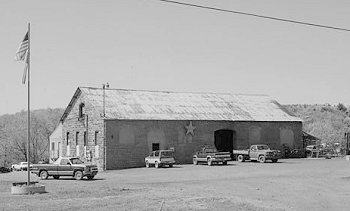
- 1992 photo -- former Merchants Coal Company Store, Morris Avenue & Stonycreek Street
- 1992 photo -- former Merchants Coal Company Office, Quemahoning Street & Morris Avenue
- Fisheries of the Stoneycreek River.