
List of Earth observation satellites
Encyclopedia
Partial list of Earth observation satellite
s by series/program.
Earth Observing System
GOES (Geostationary Operational Environmental Satellite)
National Polar-orbiting Operational Environmental Satellite System (NPOESS)
Argentina Space Agency
Centre National d'Études Spatiales
NASA
Meteosat
Meteor series
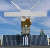
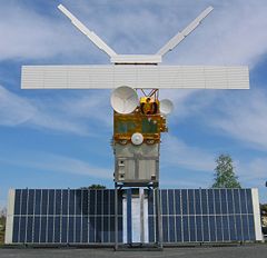
Earth observation satellite
Earth observation satellites are satellites specifically designed to observe Earth from orbit, similar to reconnaissance satellites but intended for non-military uses such as environmental monitoring, meteorology, map making etc....
s by series/program.
- See also: Timeline of Earth science satellitesTimeline of Earth science satellitesThe Timeline of Earth science satellites shows, in chronological order, those successful satellites with a program of Earth science. Sputnik 1, while the first satellite ever launched, did not conduct Earth science. Explorer 1 was the first satellite to make an Earth science discovery when it found...
, unmanned space missions, satelliteSatelliteIn the context of spaceflight, a satellite is an object which has been placed into orbit by human endeavour. Such objects are sometimes called artificial satellites to distinguish them from natural satellites such as the Moon....
s
Commercial
- Disaster Monitoring ConstellationDisaster Monitoring ConstellationThe Disaster Monitoring Constellation consists of a number of remote sensing satellites constructed by Surrey Satellite Technology Ltd and operated for the Algerian, Nigerian, Turkish, British and Chinese governments by DMC International Imaging...
- EROSEROS (satellite)Earth Resources Observation Satellite is a series of Israeli commercial Earth observation satellites, designed and manufactured by Israel Aircraft Industries , with optical payload supplied by El-Op. The satellites are owned and operated by ImageSat International, another Israeli company, with...
- FORMOSAT-2FORMOSAT-2FORMOSAT-2 is an Earth observation satellite operated by the National Space Organization of the Republic of China . It is a high-resolution photographic surveillance satellite with a daily revisit capability. Images are commercially available from Spot Image.- Launch :FORMOSAT-2 was launched...
- IKONOSIKONOSIKONOS is a commercial earth observation satellite, and was the first to collect publicly available high-resolution imagery at 1- and 4-meter resolution. It offers multispectral and panchromatic imagery. The IKONOS launch was called by John E. Pike “one of the most significant developments in...
- QuickBirdQuickBirdQuickBird is a high-resolution commercial earth observation satellite, owned by DigitalGlobe and launched in 2001 as the first satellite in a constellation of three scheduled to be in orbit by 2008...
- RapidEyeRapidEyeRapidEye AG is a German geospatial information provider focused on assisting in management decision-making through services based on their own Earth observation imagery. The company owns a five satellite constellation producing 5 meter resolution imagery that was designed and implemented by ...
- SPOTSPOT (satellites)SPOT is a high-resolution, optical imaging Earth observation satellite system operating from space. It is run by Spot Image based in Toulouse, France...
- TerraSAR-XTerraSAR-XTerraSAR-X, a German Earth observation satellite, is a joint venture being carried out under a public-private-partnership between the German Aerospace Center DLR and EADS Astrium GmbH; the exclusive commercial exploitation rights are held by the geo-information service provider Infoterra GmbH....
- COSMO-SkyMedCOSMO-SkyMedCOSMO-SkyMed is an Earth observation satellite system funded by the Italian Ministry of Research and Ministry of Defence and...
- WorldView-1WorldView-1WorldView-1 is a commercial earth observation satellite owned by DigitalGlobe. It was launched September 18, 2007, and DigitalGlobe plans to launch another, similar satellite after its construction is finished in late 2008...
- WorldView-2WorldView-2WorldView-2 is a commercial Earth observation satellite owned by DigitalGlobe. WorldView-2 provides commercially available panchromatic imagery of .5 m resolution, and eight-band multispectral imagery with resolution....
- GeoEye-1GeoEye-1GeoEye-1 is a high-resolution earth observation satellite owned by GeoEye, which was launched in September 2008.-History:On December 1, 2004, General Dynamics C4 Systems announced it had been awarded a contract worth approximately $209 million to build the OrbView-5 satellite...
Earth Observing SystemEarth Observing SystemThe Earth Observing System is a program of NASA comprising a series of artificial satellite missions and scientific instruments in Earth orbit designed for long-term global observations of the land surface, biosphere, atmosphere, and oceans of the Earth. The satellite component of the program was...
- AquaAqua (satellite)Aqua is a multi-national NASA scientific research satellite in orbit around the Earth, studying the precipitation, evaporation, and cycling of water. It is the second major component of the Earth Observing System preceded by Terra and followed by Aura .The name "Aqua" comes from the Latin word...
(EOS PM-1) - AuraAura (satellite)Aura is a multi-national NASA scientific research satellite in orbit around the Earth, studying the Earth's ozone layer, air quality and climate. It is the third major component of the Earth Observing System following on Terra and Aqua...
- GRACEGravity Recovery and Climate ExperimentThe Gravity Recovery And Climate Experiment , a joint mission of NASA and the German Space Agency, has been making detailed measurements of Earth's gravity field since its launch in March 2002....
- Jason 1Jason 1Jason-1 is a satellite oceanography mission to monitor global ocean circulation, study the ties between the ocean and the atmosphere, improve global climate forecasts and predictions, and monitor events such as El Niño and ocean eddies....
- Ocean Surface Topography MissionOcean Surface Topography MissionThe Ocean Surface Topography Mission on the Jason-2 satellite is an international Earth observation satellite mission that continues the sea surface height measurements begun in 1992 by the joint NASA/CNES TOPEX/Poseidon mission and followed by the NASA/CNES Jason-1 mission launched in 2001.Like...
- Orbview-2
- Orbiting Carbon ObservatoryOrbiting Carbon ObservatoryThe Orbiting Carbon Observatory is a NASA satellite mission intended to provide global space-based observations of atmospheric carbon dioxide . The original spacecraft was lost in a launch failure on February 24, 2009, when the payload fairing of the Taurus rocket which was carrying it failed to...
- TerraTerra (satellite)Terra is a multi-national NASA scientific research satellite in a sun-synchronous orbit around the Earth. It is the flagship of the Earth Observing System...
(EOS AM-1)
GOES (Geostationary Operational Environmental Satellite)Geostationary Operational Environmental SatelliteThe Geostationary Satellite system, operated by the United States National Environmental Satellite, Data, and Information Service , supports weather forecasting, severe storm tracking, and meteorology research. Spacecraft and ground-based elements of the system work together to provide a continuous...
- GOES 9
- GOES 10
- GOES 12
National Polar-orbiting Operational Environmental Satellite System (NPOESS)NPOESSThe National Polar-orbiting Operational Environmental Satellite System was to be the United States' next-generation satellite system that would monitor the Earth's weather, atmosphere, oceans, land and near-space environment. NPOESS satellites were to host proven technologies and operational...
- NOAA-15NOAA-15NOAA-15 is one of the NASA-provided TIROS series of weather forecasting satellite run by NOAA. It was launched on 13 May 1998, and is currently operational, in a sun-synchronous orbit, 807 km above the Earth, orbiting every 101 minutes...
- NOAA-16NOAA-16NOAA-16 is one of the NASA-provided TIROS series of weather forecasting satellite run by NOAA. It was launched on 21 September 2000, and is currently operational, in a sun-synchronous orbit, 849 km above the Earth, orbiting every 102 minutes. It hosts the AMSU, AVHRR and High Resolution...
- NOAA-17NOAA-17NOAA-17 is a weather forecasting satellite run by NOAA. It was launched on 24 June 2002, and is currently operational, in a sun-synchronous orbit, 824 km above the Earth, orbiting every 101 minutes. It hosts the AMSU, AVHRR and High Resolution Infrared Radiation Sounder instruments.APT...
- NOAA-18NOAA-18NOAA-18 is a weather forecasting satellite run by NOAA. NOAA-N was launched on May 20, 2005, into a sun-synchronous orbit at an altitude of 854 km above the Earth, with an orbital period of 102 minutes. It hosts the AMSU-A, MHS, AVHRR and High Resolution Infrared Radiation Sounder instruments, as...
- NOAA-19NOAA-19NOAA-19, designated NOAA-N prior to launch, is the last of the United States National Oceanic and Atmospheric Administration's POES series of weather satellites...
- GMS-1 / Himawari-1
- GMS-2 / Himawari-2
- GMS-3 / Himawari-3
- GMS-4 / Himawari-4
- GMS-5 / Himawari-5
Landsat program
- Landsat 1Landsat 1Landsat 1, originally named "Earth Resources Technology Satellite 1", was the first satellite of the United States' Landsat program. It was a modified version of the Nimbus 4 meteorological satellite and was launched on July 23, 1972 by a Delta 900 rocket from Vandenberg Air Force Base in California...
- Landsat 2Landsat 2Landsat 2 is the second satellite of the Landsat program. The spacecraft originally carried a designation of ERTS-B but was renamed "Landsat 2" prior to its launch on January 22, 1975...
- Landsat 3Landsat 3Landsat 3 is the third satellite of the Landsat program. It was launched on March 5, 1978, with the primary goal of providing a global archive of satellite imagery...
- Landsat 4Landsat 4Landsat 4 is the fourth satellite of the Landsat program. It was launched on July 16th, 1982, with the primary goal of providing a global archive of satellite imagery. Although the Landsat Program is managed by NASA, data from Landsat 4 was collected and distributed by the USGS...
- Landsat 5Landsat 5Landsat 5 is the fifth satellite of the Landsat program. It was launched on March 1, 1984, with the primary goal of providing a global archive of satellite photos. The Landsat Program is managed by USGS, and data from Landsat 5 is collected and distributed from the USGS's Center for Earth Resources...
- Landsat 6Landsat 6Landsat 6, equipped with upgraded versions of the instruments on its predecessor, was designed to continue the Landsat program. It was launched on October 5, 1993 using a Titan II launch vehicle, but failed to reach orbit. As a consequence, Landsat 4 and Landsat 5 were used well beyond their...
- Landsat 7Landsat 7Landsat 7, launched on April 15, 1999, is the latest satellite of the Landsat program. Landsat 7's primary goal is to refresh the global archive of satellite photos, providing up-to-date and cloud-free images. The Landsat Program is managed and operated by the USGS, and data from Landsat 7 is...
Brazilian Space Agency (AEB)
- CBERS-1
- CBERS-2
- CBERS-2B
Argentina Space AgencyComisión Nacional de Actividades EspacialesComisión Nacional de Actividades Espaciales is the civilian agency of the government of Argentina in charge of the national space program.- History :...
(CONAE)
- SAC-A
- SAC-B
- SAC-C
- SAC-DSAC-DSAC-D , also known as Aquarius after its primary instrument, is an Argentine Earth science satellite built by INVAP and launched on June 10, 2011. It carries seven instruments to study the environment, and a technology demonstration experiment. Its primary instrument, Aquarius, was built by and...
- SAOCOMSAOCOMSAOCOM is a planned Earth observation satellite series of the Argentine Space Agency CONAE. Two satellites are planned, SAOCOM 1A and SAOCOM 1B. Both will be equipped with a L-band full polarimetric Synthetic Aperture Radar...
Centre National d'Études SpatialesCNESThe is the French government space agency . Established under President Charles de Gaulle in 1961, its headquarters are located in central Paris and it is under the supervision of the French Ministries of Defence and Research...
(CNES)
- SPOTSPOT (satellites)SPOT is a high-resolution, optical imaging Earth observation satellite system operating from space. It is run by Spot Image based in Toulouse, France...
- TOPEX/PoseidonTOPEX/PoseidonLaunched in 1992, TOPEX/Poseidon was a joint satellite mission between NASA, the U.S. space agency, and CNES, the French space agency, to map ocean surface topography. The first major oceanographic research vessel to sail into space, TOPEX/Poseidon helped revolutionize oceanography by proving the...
European Space Agency (ESA)
- EnvisatEnvisatEnvisat is an Earth-observing satellite. It was launched on 1 March 2002 aboard an Ariane 5 from the Guyana Space Centre in Kourou, French Guyana into a Sun synchronous polar orbit at an altitude of...
- ERSEuropean Remote-Sensing SatelliteEuropean remote sensing satellite was the European Space Agency's first Earth-observing satellite. It was launched on July 17, 1991 into a Sun-synchronous polar orbit at a height of 782–785 km.-Instruments:...
Indian Space Research Organisation (ISRO)
- Oceansat-2Oceansat-2Oceansat-2 is an Indian satellite designed to provide service continuity for operational users of the Ocean Colour Monitor instrument on Oceansat-1. It will also enhance the potential of applications in other areas...
23 September 2009 - IMS-1IMS-1IMS-1 is an Earth observation satellite in a sun-synchronous orbit. The satellite which is the fourteenth satellite in the Indian Remote Sensing satellite series has been built, launched and maintained by the Indian Space Research Organisation...
28 April 2008 - Cartosat-2ACartosat-2ACartosat-2A is an Earth observation satellite in a sun-synchronous orbit. The satellite is the thirteenth satellite in the Indian Remote Sensing satellite series to be built, launched and maintained by the Indian Space Research Organisation...
28 April 2008 - CARTOSAT-2CARTOSAT-2Cartosat-2 is an Earth observation satellite in a sun-synchronous orbit. The satellite was built, launched and maintained by the Indian Space Research Organisation. Weighing around 680 kg at launch, its applications will mainly be towards cartography in India...
10 January 2007 - IRS P5 (CARTOSAT-1)CARTOSAT-1Cartosat-1 is a stereoscopic Earth observation satellite in a sun-synchronous orbit. The satellite was built, launched and maintained by the Indian Space Research Organisation. Weighing around 1560 kg at launch, its applications will mainly be towards cartography in India. It was launched by...
5 May 2005 - IRS P6 (Resourcesat 1)RESOURCESAT-1RESOURCESAT-1 is an advanced remote sensing satellite built by Indian Space Research Organization. The tenth satellite of ISRO in IRS series, RESOURCESAT-1 is intended to not only continue the remote sensing data services provided by IRS-1C and IRS-1D, both of which have far outlived their...
17 October 2003 - IRS P4 (Oceansat 1) 27 May 1999
- IRS P3 21 March 1996
- IRS P2 15 October 1994
- IRS P1 (also IE)(Crashed, due to launch failure of Polar Satellite Launch Vehicle, 20 September 1993)
- IRS 1D 29 September 1997
- IRS 1C 28 December 1995
- IRS 1B 29 August 1991
- IRS 1A 17 March 1988
JAXA (former NASDA)
- MOS-1MOS-1 (satellite)MOS-1 - "Marine Observation Satellite 1", also known as "Momo-1" - was Japan's first earth observation satellite. It was launched on 19 February 1987 on a N-2 rocket from Tanegashima....
(Momo-1) - MOS-1b (Momo-1b)
- JERS-1JERS-1Japanese Earth Resources Satellite 1 was a satellite launched in 1992 by the Japan Aerospace Exploration Agency...
(Fuyo-1) - ADEOSAdeosAdeos is a nanokernel hardware abstraction layer or a hypervisor that operates between computer hardware and the operating system that runs on it. It is distinct from other nanokernels, in that it is not just a low level layer for an outer kernel...
(Midori) - ADEOS IIADEOS IIADEOS II was an Earth observation satellite launched by NASDA, NASA and CNES in December 2002. Its Japanese name was Midori 2, and it was the successor to the 1996 mission ADEOS I...
(Midori II) - GOSAT (Ibuki)
- ALOSAdvanced Land Observation SatelliteAdvanced Land Observation Satellite , also called Daichi, is a 4-ton Japanese satellite. It was launched from Tanegashima island, Japan on 24 January 2006 by a H-IIA rocket. The launch had been delayed three times by weather and sensor problems...
(Daichi) PALSAR, AVNIR-2 and PRISM
NASANASAThe National Aeronautics and Space Administration is the agency of the United States government that is responsible for the nation's civilian space program and for aeronautics and aerospace research...
- TIMED (Thermosphere Ionosphere Mesosphere Energetics and Dynamics)
- TOPEX/PoseidonTOPEX/PoseidonLaunched in 1992, TOPEX/Poseidon was a joint satellite mission between NASA, the U.S. space agency, and CNES, the French space agency, to map ocean surface topography. The first major oceanographic research vessel to sail into space, TOPEX/Poseidon helped revolutionize oceanography by proving the...
- Upper Atmosphere Research SatelliteUpper Atmosphere Research SatelliteThe Upper Atmosphere Research Satellite was a NASA-operated orbital observatory whose mission was to study the Earth’s atmosphere, particularly the protective ozone layer. The satellite was deployed from Space Shuttle Discovery during the STS-48 mission on September 15, 1991...
MeteosatMeteosatThe Meteosat series of satellites are geostationary meteorological satellites operated by EUMETSAT under the Meteosat Transition Programme and the Meteosat Second Generation program....
- MetOpMetOpMetOp is a series of polar orbiting meteorological satellites operated by the European Organisation for the Exploitation of Meteorological Satellites. The satellites are all part af the EUMETSAT Polar System. It is intended to replace the soon to be retired TIROS network...
- Meteosat 5
- Meteosat 6
- Meteosat 7
- Meteosat 8
- Meteosat 9
Weather
- TIROS-1TIROS-1TIROS I was the first successful weather satellite, and the first of a series of Television Infrared Observation Satellites...
- TIROS-2
- TIROS-3
- TIROS-4
- TIROS-5
- TIROS-6
- TIROS-7
- TIROS-8
- TIROS-9
- TIROS-10
Meteor seriesMeteor (satellite)The Meteor craft are weather observation satellites launched by the USSR. The Meteor satellites were designed to monitor atmospheric and sea-surface temperatures, humidity, radiation, sea ice conditions, snow-cover, and clouds.-Meteor 2-21:...
- Meteor 1 series
- Meteor 2 series
- Meteor 3 series
FY (Feng Yun) series
- FY-1 series
- FY-2 series
- FY-3A