

Gravity Recovery and Climate Experiment
Encyclopedia
The Gravity Recovery And Climate Experiment (GRACE), a joint mission of NASA
and the German Space Agency
, has been making detailed measurements of Earth's gravity
field since its launch in March 2002.
Gravity
is determined by mass
. By measuring gravity, GRACE shows how mass is distributed around the planet and how it varies over time. GRACE data are important tools for studying Earth's ocean
, geology
, and climate
.
GRACE is a collaborative endeavor involving the Center for Space Research at the University of Texas, Austin; NASA's Jet Propulsion Laboratory
, Pasadena, Calif.; the German Space Agency and Germany's National Research Center for Geosciences, Potsdam. The Jet Propulsion Laboratory is responsible for the overall mission management under the NASA ESSP program.
The principal investigator is Dr. Byron Tapley of the University of Texas Center for Space Research, and the co-principal investigator is Dr. Christoph Reigber of the GeoForschungsZentrum (GFZ) Potsdam.
The GRACE satellites were launched from Plesetsk Cosmodrome
, Russia on a Rockot
(SS-19 + Breeze upper stage) launch vehicle, on March 17, 2002.
, glaciologists
, geologists and other scientists to study phenomena that influence climate.
From the thinning of ice sheets to the flow of water through aquifers and the slow currents of magma
inside Earth
, measurements of the amount of mass involved provided by GRACE help scientists better understand these important natural processes.
 Among the first important applications for GRACE data was to improve the understanding of global ocean circulation. The hills and valleys in the ocean's surface are due to currents and variations in Earth's gravity field. GRACE enables separation of those two effects to better measure ocean currents and their effect on climate. GRACE data are also critical in helping to determine the cause of sea level rise, whether it is the result of mass being added to the ocean, from melting glaciers, for example, or from thermal expansion
of warming water or changes in salinity
.
The data so far obtained by GRACE are the most precise gravimetric data yet recorded: they have been used to re-analyse data obtained from the LAGEOS
experiment to try to measure the relativistic frame-dragging
effect.
In 2006, a team of researchers led by Ralph von Frese and Laramie Potts used GRACE data to discover the 480 kilometres (298.3 mi) wide Wilkes Land crater
in Antarctica, which probably formed about 250 million years ago.
GRACE has been used to map the hydrologic cycle in the Amazon River basin
and the location and magnitude of post-glacial rebound
from changes in the free air gravity anomaly.
GRACE data has also been used to analyze the shifts in the Earth's crust caused by the earthquake that created the 2004 Indian Ocean tsunami. Scientists have recently developed a new way to calculate ocean bottom pressure—as important to oceanographers as atmospheric pressure is to meteorologists—using GRACE data.
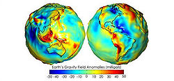
As the twin GRACE satellites circle the globe 15 times a day, they sense minute variations in Earth's gravitational pull. When the first satellite passes over a region of slightly stronger gravity, a gravity anomaly
, it is pulled slightly ahead of the trailing satellite. This causes the distance between the satellites to increase. The first spacecraft then passes the anomaly, and slows down again; meanwhile the following spacecraft accelerates, then decelerates over the same point.
By measuring the constantly changing distance between the two satellites and combining that data with precise positioning measurements from Global Positioning System
(GPS) instruments, scientists can construct a detailed map of Earth's gravity.
The two satellites (nicknamed "Tom" and "Jerry") constantly maintain a two-way microwave-ranging link between them. Fine distance measurements are made by comparing frequency shifts of the link. As a cross-check, the vehicles measure their own movements using accelerometers. All of this information is then downloaded to ground stations.
To establish baseline positions and fulfill housekeeping functions, the satellites also use star cameras, magnetometers, and GPS receivers. The GRACE vehicles also have optical corner reflectors to enable laser ranging from ground stations, bridging the range between spacecraft positions and Doppler ranges.
of Germany
, using its "Flexbus" platform. The microwave RF
systems, and attitude determination and control system algorithms were provided by Space Systems/Loral
. The star cameras used to measure the spacecraft attitude were provided by Technical University of Denmark
. The instrument computer along with a highly precise BlackJack GPS receiver and digital signal processing system has been provided by JPL
in Pasadena. The highly precise accelerometer that is needed to separate atmospheric and solar wind effects from the gravitation data was manufactured by ONERA
.
NASA
The National Aeronautics and Space Administration is the agency of the United States government that is responsible for the nation's civilian space program and for aeronautics and aerospace research...
and the German Space Agency
German Aerospace Center
The German Aerospace Center is the national centre for aerospace, energy and transportation research of the Federal Republic of Germany. It has multiple locations throughout Germany. Its headquarters are located in Cologne. It is engaged in a wide range of research and development projects in...
, has been making detailed measurements of Earth's gravity
Earth's gravity
The gravity of Earth, denoted g, refers to the acceleration that the Earth imparts to objects on or near its surface. In SI units this acceleration is measured in metres per second per second or equivalently in newtons per kilogram...
field since its launch in March 2002.
Gravity
Gravitation
Gravitation, or gravity, is a natural phenomenon by which physical bodies attract with a force proportional to their mass. Gravitation is most familiar as the agent that gives weight to objects with mass and causes them to fall to the ground when dropped...
is determined by mass
Mass
Mass can be defined as a quantitive measure of the resistance an object has to change in its velocity.In physics, mass commonly refers to any of the following three properties of matter, which have been shown experimentally to be equivalent:...
. By measuring gravity, GRACE shows how mass is distributed around the planet and how it varies over time. GRACE data are important tools for studying Earth's ocean
Ocean
An ocean is a major body of saline water, and a principal component of the hydrosphere. Approximately 71% of the Earth's surface is covered by ocean, a continuous body of water that is customarily divided into several principal oceans and smaller seas.More than half of this area is over 3,000...
, geology
Geology
Geology is the science comprising the study of solid Earth, the rocks of which it is composed, and the processes by which it evolves. Geology gives insight into the history of the Earth, as it provides the primary evidence for plate tectonics, the evolutionary history of life, and past climates...
, and climate
Climate
Climate encompasses the statistics of temperature, humidity, atmospheric pressure, wind, rainfall, atmospheric particle count and other meteorological elemental measurements in a given region over long periods...
.
GRACE is a collaborative endeavor involving the Center for Space Research at the University of Texas, Austin; NASA's Jet Propulsion Laboratory
Jet Propulsion Laboratory
Jet Propulsion Laboratory is a federally funded research and development center and NASA field center located in the San Gabriel Valley area of Los Angeles County, California, United States. The facility is headquartered in the city of Pasadena on the border of La Cañada Flintridge and Pasadena...
, Pasadena, Calif.; the German Space Agency and Germany's National Research Center for Geosciences, Potsdam. The Jet Propulsion Laboratory is responsible for the overall mission management under the NASA ESSP program.
The principal investigator is Dr. Byron Tapley of the University of Texas Center for Space Research, and the co-principal investigator is Dr. Christoph Reigber of the GeoForschungsZentrum (GFZ) Potsdam.
The GRACE satellites were launched from Plesetsk Cosmodrome
Plesetsk Cosmodrome
Plesetsk Cosmodrome is a Russian spaceport, located in Arkhangelsk Oblast, about 800 km north of Moscow and approximately 200 km south of Arkhangelsk.-Overview:...
, Russia on a Rockot
Rockot
The Rokot , also transliterated as a the pun Rockot, is a Russian space launch vehicle that can launch a payload of 1,950 kilograms into a 200 kilometre high Earth orbit with 63° inclination. It is a derivative of the UR-100N intercontinental ballistic missile , supplied and operated by Eurockot...
(SS-19 + Breeze upper stage) launch vehicle, on March 17, 2002.
Discoveries and applications
The monthly gravity maps generated by Grace are up to 1,000 times more accurate than previous maps, substantially improving the accuracy of many techniques used by oceanographers, hydrologistsHydrology
Hydrology is the study of the movement, distribution, and quality of water on Earth and other planets, including the hydrologic cycle, water resources and environmental watershed sustainability...
, glaciologists
Glaciology
Glaciology Glaciology Glaciology (from Middle French dialect (Franco-Provençal): glace, "ice"; or Latin: glacies, "frost, ice"; and Greek: λόγος, logos, "speech" lit...
, geologists and other scientists to study phenomena that influence climate.
From the thinning of ice sheets to the flow of water through aquifers and the slow currents of magma
Magma
Magma is a mixture of molten rock, volatiles and solids that is found beneath the surface of the Earth, and is expected to exist on other terrestrial planets. Besides molten rock, magma may also contain suspended crystals and dissolved gas and sometimes also gas bubbles. Magma often collects in...
inside Earth
Earth
Earth is the third planet from the Sun, and the densest and fifth-largest of the eight planets in the Solar System. It is also the largest of the Solar System's four terrestrial planets...
, measurements of the amount of mass involved provided by GRACE help scientists better understand these important natural processes.
Thermal expansion
Thermal expansion is the tendency of matter to change in volume in response to a change in temperature.When a substance is heated, its particles begin moving more and thus usually maintain a greater average separation. Materials which contract with increasing temperature are rare; this effect is...
of warming water or changes in salinity
Salinity
Salinity is the saltiness or dissolved salt content of a body of water. It is a general term used to describe the levels of different salts such as sodium chloride, magnesium and calcium sulfates, and bicarbonates...
.
The data so far obtained by GRACE are the most precise gravimetric data yet recorded: they have been used to re-analyse data obtained from the LAGEOS
LAGEOS
LAGEOS, or Laser Geodynamics Satellites, are a series of scientific research satellites designed to provide an orbiting laser ranging benchmark for geodynamical studies of the Earth...
experiment to try to measure the relativistic frame-dragging
Frame-dragging
Einstein's general theory of relativity predicts that non-static, stationary mass-energy distributions affect spacetime in a peculiar way giving rise to a phenomenon usually known as frame-dragging...
effect.
In 2006, a team of researchers led by Ralph von Frese and Laramie Potts used GRACE data to discover the 480 kilometres (298.3 mi) wide Wilkes Land crater
Wilkes Land crater
Wilkes Land crater is an informal term that may apply to two separate cases of conjectured giant impact craters hidden beneath the ice cap of Wilkes Land, East Antarctica...
in Antarctica, which probably formed about 250 million years ago.
GRACE has been used to map the hydrologic cycle in the Amazon River basin
Amazon Basin
The Amazon Basin is the part of South America drained by the Amazon River and its tributaries that drains an area of about , or roughly 40 percent of South America. The basin is located in the countries of Bolivia, Brazil, Colombia, Ecuador, Guyana, Peru, and Venezuela...
and the location and magnitude of post-glacial rebound
Post-glacial rebound
Post-glacial rebound is the rise of land masses that were depressed by the huge weight of ice sheets during the last glacial period, through a process known as isostasy...
from changes in the free air gravity anomaly.
GRACE data has also been used to analyze the shifts in the Earth's crust caused by the earthquake that created the 2004 Indian Ocean tsunami. Scientists have recently developed a new way to calculate ocean bottom pressure—as important to oceanographers as atmospheric pressure is to meteorologists—using GRACE data.
How GRACE works
GRACE is the first Earth-monitoring mission in the history of space flight whose key measurement is not derived from electromagnetic waves either reflected off, emitted by, or transmitted through Earth's surface and/or atmosphere. Instead, the mission uses a microwave ranging system to accurately measure changes in the speed and distance between two identical spacecraft flying in a polar orbit about 220 kilometres (136.7 mi) apart, 500 kilometres (310.7 mi) above Earth. The ranging system is sensitive enough to detect separation changes as small as 10 micrometres (approximately one-tenth the width of a human hair) over a distance of 220 kilometers.As the twin GRACE satellites circle the globe 15 times a day, they sense minute variations in Earth's gravitational pull. When the first satellite passes over a region of slightly stronger gravity, a gravity anomaly
Gravity anomaly
A gravity anomaly is the difference between the observed acceleration of Earth's gravity and a value predicted from a model.-Geodesy and geophysics:...
, it is pulled slightly ahead of the trailing satellite. This causes the distance between the satellites to increase. The first spacecraft then passes the anomaly, and slows down again; meanwhile the following spacecraft accelerates, then decelerates over the same point.
By measuring the constantly changing distance between the two satellites and combining that data with precise positioning measurements from Global Positioning System
Global Positioning System
The Global Positioning System is a space-based global navigation satellite system that provides location and time information in all weather, anywhere on or near the Earth, where there is an unobstructed line of sight to four or more GPS satellites...
(GPS) instruments, scientists can construct a detailed map of Earth's gravity.
The two satellites (nicknamed "Tom" and "Jerry") constantly maintain a two-way microwave-ranging link between them. Fine distance measurements are made by comparing frequency shifts of the link. As a cross-check, the vehicles measure their own movements using accelerometers. All of this information is then downloaded to ground stations.
To establish baseline positions and fulfill housekeeping functions, the satellites also use star cameras, magnetometers, and GPS receivers. The GRACE vehicles also have optical corner reflectors to enable laser ranging from ground stations, bridging the range between spacecraft positions and Doppler ranges.
Spacecraft
The spacecraft were manufactured by AstriumEADS Astrium
Astrium Satellites is one of the three business units of Astrium, a subsidiary of EADS. It is a European space manufacturer involved in the manufacture of spacecraft used for science, Earth observation and telecommunication, as well as the equipment and subsystems used therein and related ground...
of Germany
Germany
Germany , officially the Federal Republic of Germany , is a federal parliamentary republic in Europe. The country consists of 16 states while the capital and largest city is Berlin. Germany covers an area of 357,021 km2 and has a largely temperate seasonal climate...
, using its "Flexbus" platform. The microwave RF
Radio frequency
Radio frequency is a rate of oscillation in the range of about 3 kHz to 300 GHz, which corresponds to the frequency of radio waves, and the alternating currents which carry radio signals...
systems, and attitude determination and control system algorithms were provided by Space Systems/Loral
Space Systems/Loral
Space Systems/Loral , of Palo Alto, California, is the wholly owned manufacturing subsidiary of Loral Space & Communications. It was acquired in 1990 for $715 million by Loral Corp. from Ford Motor Company as the Space Systems Division of Ford Aerospace...
. The star cameras used to measure the spacecraft attitude were provided by Technical University of Denmark
Technical University of Denmark
The Technical University of Denmark , often simply referred to as DTU, is a university just north of Copenhagen, Denmark. It was founded in 1829 at the initiative of Hans Christian Ørsted as Denmark's first polytechnic, and is today ranked among Europe's leading engineering institutions, and the...
. The instrument computer along with a highly precise BlackJack GPS receiver and digital signal processing system has been provided by JPL
Jet Propulsion Laboratory
Jet Propulsion Laboratory is a federally funded research and development center and NASA field center located in the San Gabriel Valley area of Los Angeles County, California, United States. The facility is headquartered in the city of Pasadena on the border of La Cañada Flintridge and Pasadena...
in Pasadena. The highly precise accelerometer that is needed to separate atmospheric and solar wind effects from the gravitation data was manufactured by ONERA
Office National d'Etudes et de Recherches Aerospatiales
Office National d'Études et de Recherches Aérospatiales or Onera is the French aerospace research center. It is a public establishment with industrial and commercial operations, and carries out application-oriented research to support enhanced innovation and competitiveness in the aerospace and...
.
See also
- GeoidGeoidThe geoid is that equipotential surface which would coincide exactly with the mean ocean surface of the Earth, if the oceans were in equilibrium, at rest , and extended through the continents . According to C.F...
- Gravity Field and Steady-State Ocean Circulation ExplorerGravity Field and Steady-State Ocean Circulation ExplorerThe Gravity Field and Steady-State Ocean Circulation Explorer is an ESA satellite that was launched on March 17, 2009. It is a satellite carrying a highly sensitive gravity gradiometer which detects fine density differences in the crust and oceans of the Earth.GOCE data will have many uses,...
(GOCE, launched March 2009) - Gravity Recovery and Interior LaboratoryGravity Recovery and Interior LaboratoryThe Gravity Recovery and Interior Laboratory is an American lunar science mission in NASA's Discovery Program, which will use high-quality gravitational field mapping of the Moon to determine its interior structure...
(GRAIL, a similar probe intended to map the moon)
External links
- GRACE mission home page (Primary Investigator)
- GRACE Tellus (JPL)
- GRACE mission home page (co Primary Investigator) (language: German)
- GRACE Mission Profile by NASA's Solar System Exploration
- Science@NASA article about GRACE
- Weighing Earth's Water from Space Estimating ground water using GRACE (written for non-scientists)
- Report by BBC showing early results
- GPS World Discussion of instrumentation