
Kirkburton
Encyclopedia
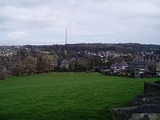
Kirkburton is a village
, civil parish and local government ward in the metropolitan county
of West Yorkshire
, England
, 5 miles (8 km) south east of Huddersfield
, in the Metropolitan Borough of Kirklees
. The township comprises the two villages of Kirkburton and Highburton
together with several hamlets, including Thunderbridge, Thorncliffe, Storthes Hall
, Burton Royd, Riley, Dogley, Common Side, Causeway Foot, Lane Head and Linfit. According to the 2001 census the parish had a population of 23,986, while in 2008 it was estimated that the village had a population of 1,970.
when a settlement was believed to have been built on the site of the present church. A Saxon
Fort is also believed to have stood on that site. The village is recorded in the Domesday Book
as Bertone in Wachefeld. The entry reads (translated):
"In Wakefield
, with 9 Berewicks... are 60 carucate
s of land 3 bovates and the third part of 1 bovate to the geld
. 30 ploughs could plough this land. This manor was in the demesne of King Edward
; now, in the king's hand, there are 4 villans, and 3 priests and 2 churches, and 7 sokemen and 16 bordars. Together, they have 7 ploughs. [There is] woodland pasture 6 leagues long and 4 leagues broad. The whole [is] 6 leagues long and 6 leagues broad... To this manor belongs the soke of these lands... Kirkburton, 3 carucates... in all, there are 30 carucates to the geld, which 20 ploughs could plough. Now they are waste"
 After the Norman Conquest the village grew from the waste recorded in 1086. The two parts of the village were named after the church was built in 1190, Kirkburton housed the church whilst Highburton was built on the hill. In the Middle Ages
the township was part of the Manor of Wakefield and Kirkburton church was at the head of a 16000 acres (64.7 km²) parish
, that extended to the Holme Valley
.
During the First English Civil War
the villagers supported the Parliamentary
cause. The priest, Gamaliel Whitaker, angered his parishioners by supporting the Royalists
. He was denounced to the government forces who went to arrest him in 1644. During the struggle the soldiers shot his wife, Hester, in the ensuing confusion. Legend has it that her ghost haunts the old vicarage.
 The population of the township increased with the growth of the textile trades. By 1800 the population was about 1400: 60 years later it was approaching 3700. After this, there was a general decline in the population and for nearly a century the figure was around 3000. In 1971 there were 2800 inhabitants, but following housing developments at Highburton the population is nearer 5000.
The Huddersfield-Kirkburton Branch Line opened in 1867, serving the 2 terminal stations as well as Deighton
, Kirkheaton
, Fenay Bridge and Lepton. It was very unusual in that it was operated by the London and North Western Railway
company in an area where the Lancashire and Yorkshire Railway
company had a virtual monopoly. Plans to extend the line to Barnsley never materialised and so Kirkburton remained at the end of the line. It was primarily used for the transportation of goods, although passenger services ran until 1930. The line continued to be used to transport goods until the 1960s, when a combination of road haulage and a decline in industry around the village lead to closure of the station in 1965. Evidence of the railway remains in the area around Northwood Park, a housing development built on the old route. Parts of the station still remain, albeit in ruined state, whilst the bricked up tunnel can be clearly seen when travelling into the village centre from Penistone Road.
A psychiatric hospital
operated at Storthes Hall from 1904-1991. It was founded as an asylum
and was previously called the Storthes Hall Mental Hospital (1929–1938), the West Riding
Mental Hospital (1939–1948)and Storthes Hall Hospital (1949–1991). After it was closed the land was sold to the University of Huddersfield
and halls of residence built. Most of the former site is now home to the Storthes Hall Park Student Village, with the remaining area due for further development as a retirement village.
Kirkburton thrived on a variety of industrial advances, particularly in wool
and coal
. The gradual decline of these industries gave way to the villages small but thriving shopping centre. Kirkburton remains the commercial heart of the township, whilst Highburton has become the residential centre.
the finished cloth. About 1800 another mill opened at Linfit, which used steam power to carry out the same activities. Both mills gradually took on other processes and developed into substantial businesses under the Kenyon and Hey families. By 1880 there were eight mills at work in the township.
The tanning
of leather and exploitation of coal
seams made valuable contributions to the economy of Kirkburton for several centuries. The last tannery closed in the 1830s. Coal mining
grew in importance with the increased use of steam for pumping water and by 1850 there were no fewer than 20 small pits in the township. The remains of a number of mines and bell pits can still be seen, including the former St Helen's Colliery on Moor Lane in Highburton. In the latter half of the 19th century there were over 30 pits operating around Kirkburton employing over 300 men. The last colliery closed about 70 years ago. One old-established industry, which has recently moved from the village, is the manufacture of edge tools and shovels, which was introduced in the mid-18th century. The last factory, Carters, moved to new premises a few years ago.
In 2006 Shepley Spring Ltd acquired the former Whitley Willows Textile site in Kirkburton and set up a volume bottled water plant, utilising the vast high quality ground water sources in this area. Known as Shepley Spring Brookfield, this site now operates 24 hours a day and produces tens of millions of bottles for UK Supermarkets and wholesalers.
Kirkburton Cricket Club was founded at the Rose and Crown Inn on February 25, 1860. The public house, at the bottom of Slant Gate, is now a private residence. The club initially played at Turnshaws until moving to the ground at Riley in 1878. The club was a founding member of the Huddersfield and District Alliance in 1893. Former England cricketer Phil Defreitas played for the club in 1995.
The Gregory Fields Tennis Club, formerly the Fenay Bridge Tennis Club, was built on Burton Acres Lane with lottery assistance in 2000. The club has changing facilities and three floodlit macadam courts.
 Kirkburton is the home to Kirkburton First School and Kirkburton Middle School. The Adult Education Centre and Special School on Turnshaw Avenue closed in 2006. The village has a partially manned police station, masonic hall, 6 public houses, purpose built health centre (opened October 2005) and dental surgery. The largest housing areas can be found in the areas occupying Riley, Low Town, Brickfields and Turnshaws. North Road and George Street form the main road through the village and houses the majority of shops and businesses.
Kirkburton has a Rapier Dance Team, who perform traditional longsword dances
each New Year's Day
at pubs in the villages of Kirkburton and Highburton in addition to their numerous appearances at festivals elsewhere in the country. Rapier dancing was a tradition in the village up to the beginning of the 20th century, and was revived in 1974. The team adhere to what is largely believed to be the original dress of clogs, blue waistcoats and trousers with ribbons down the side. The final tradition, that of blackened faces, is only adopted during the New Year performances.
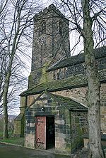 All Hallows Church: Dedicated to All Hallows, the church was built in 1190 and is a Grade I Listed Building. Most of the church is 13th century although parts have been rebuilt. The tower was added in the 15th century. Inside the church is a late medieval nave ceiling, large wooden pulpit, stone font and Elizabethan and Jacobean
pews. A small window in the chancel may have opened from the cell of a hermit. A Restored 10th century stone crucifix can be found inside, supporting the belief that another church or Christian
settlement may have existed on this site. The church has recently undergone extensive restoration. The churchyard has also undergone landscaping and is a designated wildlife sanctuary.
The Masonic Hall: Located opposite the police station and All Hallows Church on George Street. The Hall was built in 1889 in a mock Tudor style and was built as a meeting hall for the local Freemasons. The Beaumont Lodge have met in the building ever since.
The George Inn: The oldest public house
in the village was built in the 18th century and has operated as a pub ever since. It is located on George Street, next to the old blacksmiths, and is overlooked by All Hallows Church. In 1777 commissioners met there to agree upon the creation of the Halifax
to Penistone
Turnpike, the forerunner for the present Penistone Road.
Salvation Army Citadel: The Salvation Army
Corps was established in the village in 1885. Their present headquarters were opened in 1964. The Salvation Army left the village in 2005 and the building has been unoccupied since, although is occasionally used for charitable events.
The Royal Hotel: Victorian
public house built in stone in 1870. The second largest pub in the village is located in the centre of the village on North Road.
Methodist Chapel: The original chapel was built at Ponty in 1816 but moved to North Road in 1845. This is located on the hill just off the main road that runs behind the old library. The chapel closed in 1987 and is a private residence.
Springfield Mill: The oldest part was built as a warehouse about 1830. The main building, in a similar style but larger, was added for spinning in 1834 and the weaving sheds opposite in 1849. After the church this is perhaps the most important piece of architecture in the village. Part of the mill has been converted into flats.
The Town Hall: The owners of the nearby mill built Springfield House in the 1830s. It was bought by Kirkburton Urban District Council in 1935 and taken over as a Town Hall three years later. The council sold it in 1982. It is a Grade II Listed Building (1978) and a private residence with the grand, if inaccurate, name of "Kirkburton Hall".
The Foxglove: The largest public house in the village, it was built in 1868 in a mock Tudor style at the same time as the branch line. It was hoped that Kirkburton would become a junction to an extended line to Barnsley, hence the pubs original name "The Railway Junction", but this never materialised. The public house was more popularly known as "The Three Owls" up until 2000 when it adopted its new name. An extension was built in 2001 which is now the hotel part of the building.
 Highburton Cross: Marking the site of the medieval market, the steps at the base probably date from the 14th century, the shaft and ball from the 18th or 19th. The cross stands at the top of Far Dene at its junction with Town Gate and Hall Lane.
Burton Village Hall: Formerly Highburton School, the Village Hall was extensively renovated in 1999 with funds raised by the local community and a grant from the National Lottery Fund
. It is the home to Kirkburton Parish Council and a number of groups.
Highburton Co-op
: Was located on Towngate in the centre of the village, the Co-op
laid claim to being the world's oldest operating independent single retail cooperative outlet until its closure in February 2009. The building was purchased from the church in 1856 and began trading in the same year. It has re-opened since it's closure.
The Smiths Arms: Located at the summit of Far Dene, the Grade II Listed Smiths Arms is the only public house
in the village and occupies one of its oldest buildings. Built in 1669 in a Tudor/Jacobean style, it began trading as a public house in 1830. Whilst it is the oldest pub building in the township it is not the oldest public house. That honour goes to the George Inn in Kirkburton, which dates back to the 18th century.
Primitive Methodist Chapel: The primitive Methodists built their chapel at the top of Slant Gate in 1832. A school, now demolished, was built in 1899 and the chapel was enlarged in 1926. Like the Methodist chapel in Kirkburton it too closed, this time in 1973, and is also a private house.
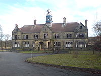 Storthes Hall Hospital: Most of the grounds of the former psychiatric hospital were sold to the University of Huddersfield and few of the buildings remain. The one remaining is the main hospital building with its clock tower. The building is in disrepair but is due for renovation as part of a proposed retirement village.
Storthes Hall Mansion: Built in the late 19th century as a private house for the Horsefall family. Taken over as an asylum in 1904, it became known as the Mansion Hospital and operated as a psychiatric institution alongside the main hospital, its last years saw it providing institutional care for people with learning disabilities, finally closing in 1991. It too was sold to the University of Huddersfield in 1994. The building became Grade II Listed in June 1965. It is now again a private residence "The Mansion".
Myers Wood: Recent archaeological excavations have uncovered the most complete iron working site in the North of England at Myers Wood
. The Cistercian monastic site was in operation from 12th-14th century, using advanced techniques and water power for smelting and smithing iron.
Village
A village is a clustered human settlement or community, larger than a hamlet with the population ranging from a few hundred to a few thousand , Though often located in rural areas, the term urban village is also applied to certain urban neighbourhoods, such as the West Village in Manhattan, New...
, civil parish and local government ward in the metropolitan county
Metropolitan county
The metropolitan counties are a type of county-level administrative division of England. There are six metropolitan counties, which each cover large urban areas, typically with populations of 1.2 to 2.8 million...
of West Yorkshire
West Yorkshire
West Yorkshire is a metropolitan county within the Yorkshire and the Humber region of England with a population of 2.2 million. West Yorkshire came into existence as a metropolitan county in 1974 after the passage of the Local Government Act 1972....
, England
England
England is a country that is part of the United Kingdom. It shares land borders with Scotland to the north and Wales to the west; the Irish Sea is to the north west, the Celtic Sea to the south west, with the North Sea to the east and the English Channel to the south separating it from continental...
, 5 miles (8 km) south east of Huddersfield
Huddersfield
Huddersfield is a large market town within the Metropolitan Borough of Kirklees, in West Yorkshire, England, situated halfway between Leeds and Manchester. It lies north of London, and south of Bradford, the nearest city....
, in the Metropolitan Borough of Kirklees
Kirklees
The Metropolitan Borough of Kirklees is a metropolitan borough of West Yorkshire, England. It has a population of 401,000 and includes the settlements of Batley, Birstall, Cleckheaton, Denby Dale, Dewsbury, Heckmondwike, Holmfirth, Huddersfield, Kirkburton, Marsden, Meltham, Mirfield and Slaithwaite...
. The township comprises the two villages of Kirkburton and Highburton
Highburton
Highburton is part of the township of Kirkburton, a village in the county of West Yorkshire, England. It is located five miles southeast of Huddersfield...
together with several hamlets, including Thunderbridge, Thorncliffe, Storthes Hall
Storthes Hall
Storthes Hall is a part of the township of Kirkburton, West Yorkshire, England. A heavily wooded area, it comprises a single road, Storthes Hall Lane, which links Kirkburton with the nearby villages of Farnley Tyas and Thurstonland. To the immediate north is North Spring Wood. Boothroyd Wood...
, Burton Royd, Riley, Dogley, Common Side, Causeway Foot, Lane Head and Linfit. According to the 2001 census the parish had a population of 23,986, while in 2008 it was estimated that the village had a population of 1,970.
History
The origins of the village date back to the Iron AgeIron Age
The Iron Age is the archaeological period generally occurring after the Bronze Age, marked by the prevalent use of iron. The early period of the age is characterized by the widespread use of iron or steel. The adoption of such material coincided with other changes in society, including differing...
when a settlement was believed to have been built on the site of the present church. A Saxon
Anglo-Saxons
Anglo-Saxon is a term used by historians to designate the Germanic tribes who invaded and settled the south and east of Great Britain beginning in the early 5th century AD, and the period from their creation of the English nation to the Norman conquest. The Anglo-Saxon Era denotes the period of...
Fort is also believed to have stood on that site. The village is recorded in the Domesday Book
Domesday Book
Domesday Book , now held at The National Archives, Kew, Richmond upon Thames in South West London, is the record of the great survey of much of England and parts of Wales completed in 1086...
as Bertone in Wachefeld. The entry reads (translated):
"In Wakefield
Wakefield
Wakefield is the main settlement and administrative centre of the City of Wakefield, a metropolitan district of West Yorkshire, England. Located by the River Calder on the eastern edge of the Pennines, the urban area is and had a population of 76,886 in 2001....
, with 9 Berewicks... are 60 carucate
Carucate
The carucate or ploughland was a unit of assessment for tax used in most Danelaw counties of England, and is found for example in Domesday Book. The carucate was based on the area a plough team of eight oxen could till in a single annual season...
s of land 3 bovates and the third part of 1 bovate to the geld
Geld
Geld may refer to:* Money, in Dutch or German languages* Danegeld, or any Anglo-Saxon or Norman land tax often based on hides* Weregeld* Gelt, Yiddish for money* Gelding, castrated animal-See also:* Gold * Gel...
. 30 ploughs could plough this land. This manor was in the demesne of King Edward
Edward the Confessor
Edward the Confessor also known as St. Edward the Confessor , son of Æthelred the Unready and Emma of Normandy, was one of the last Anglo-Saxon kings of England and is usually regarded as the last king of the House of Wessex, ruling from 1042 to 1066....
; now, in the king's hand, there are 4 villans, and 3 priests and 2 churches, and 7 sokemen and 16 bordars. Together, they have 7 ploughs. [There is] woodland pasture 6 leagues long and 4 leagues broad. The whole [is] 6 leagues long and 6 leagues broad... To this manor belongs the soke of these lands... Kirkburton, 3 carucates... in all, there are 30 carucates to the geld, which 20 ploughs could plough. Now they are waste"
Middle Ages
The Middle Ages is a periodization of European history from the 5th century to the 15th century. The Middle Ages follows the fall of the Western Roman Empire in 476 and precedes the Early Modern Era. It is the middle period of a three-period division of Western history: Classic, Medieval and Modern...
the township was part of the Manor of Wakefield and Kirkburton church was at the head of a 16000 acres (64.7 km²) parish
Parish
A parish is a territorial unit historically under the pastoral care and clerical jurisdiction of one parish priest, who might be assisted in his pastoral duties by a curate or curates - also priests but not the parish priest - from a more or less central parish church with its associated organization...
, that extended to the Holme Valley
Holme Valley
Holme Valley is a large civil parish in the Metropolitan Borough of Kirklees in West Yorkshire, England. It has a population of 25,049 . Its administrative centre is in Holmfirth. Other sizeable settlements in the parish include, Brockholes, Honley and New Mill...
.
During the First English Civil War
First English Civil War
The First English Civil War began the series of three wars known as the English Civil War . "The English Civil War" was a series of armed conflicts and political machinations that took place between Parliamentarians and Royalists from 1642 until 1651, and includes the Second English Civil War and...
the villagers supported the Parliamentary
Roundhead
"Roundhead" was the nickname given to the supporters of the Parliament during the English Civil War. Also known as Parliamentarians, they fought against King Charles I and his supporters, the Cavaliers , who claimed absolute power and the divine right of kings...
cause. The priest, Gamaliel Whitaker, angered his parishioners by supporting the Royalists
Cavalier
Cavalier was the name used by Parliamentarians for a Royalist supporter of King Charles I and son Charles II during the English Civil War, the Interregnum, and the Restoration...
. He was denounced to the government forces who went to arrest him in 1644. During the struggle the soldiers shot his wife, Hester, in the ensuing confusion. Legend has it that her ghost haunts the old vicarage.
The Huddersfield-Kirkburton Branch Line opened in 1867, serving the 2 terminal stations as well as Deighton
Deighton, West Yorkshire
Deighton is a district of Huddersfield, West Yorkshire, England. It is situated north west of the town centre and lies off the A62 Leeds Road....
, Kirkheaton
Kirkheaton
Kirkheaton is a village north east of Huddersfield, West Yorkshire, England and has a population of 4,209 together with Upper Heaton.- Education :Kirkheaton has a primary school, Kirkheaton Primary School, which is situated on New Road....
, Fenay Bridge and Lepton. It was very unusual in that it was operated by the London and North Western Railway
London and North Western Railway
The London and North Western Railway was a British railway company between 1846 and 1922. It was created by the merger of three companies – the Grand Junction Railway, the London and Birmingham Railway and the Manchester and Birmingham Railway...
company in an area where the Lancashire and Yorkshire Railway
Lancashire and Yorkshire Railway
The Lancashire and Yorkshire Railway was a major British railway company before the 1923 Grouping. It was incorporated in 1847 from an amalgamation of several existing railways...
company had a virtual monopoly. Plans to extend the line to Barnsley never materialised and so Kirkburton remained at the end of the line. It was primarily used for the transportation of goods, although passenger services ran until 1930. The line continued to be used to transport goods until the 1960s, when a combination of road haulage and a decline in industry around the village lead to closure of the station in 1965. Evidence of the railway remains in the area around Northwood Park, a housing development built on the old route. Parts of the station still remain, albeit in ruined state, whilst the bricked up tunnel can be clearly seen when travelling into the village centre from Penistone Road.
A psychiatric hospital
Hospital
A hospital is a health care institution providing patient treatment by specialized staff and equipment. Hospitals often, but not always, provide for inpatient care or longer-term patient stays....
operated at Storthes Hall from 1904-1991. It was founded as an asylum
Psychiatric hospital
Psychiatric hospitals, also known as mental hospitals, are hospitals specializing in the treatment of serious mental disorders. Psychiatric hospitals vary widely in their size and grading. Some hospitals may specialise only in short-term or outpatient therapy for low-risk patients...
and was previously called the Storthes Hall Mental Hospital (1929–1938), the West Riding
West Riding of Yorkshire
The West Riding of Yorkshire is one of the three historic subdivisions of Yorkshire, England. From 1889 to 1974 the administrative county, County of York, West Riding , was based closely on the historic boundaries...
Mental Hospital (1939–1948)and Storthes Hall Hospital (1949–1991). After it was closed the land was sold to the University of Huddersfield
University of Huddersfield
The University of Huddersfield is a university located in Huddersfield, West Yorkshire, England.- History :The University traces its roots back to a Science and Mechanic Institute founded in 1825...
and halls of residence built. Most of the former site is now home to the Storthes Hall Park Student Village, with the remaining area due for further development as a retirement village.
Kirkburton thrived on a variety of industrial advances, particularly in wool
Wool
Wool is the textile fiber obtained from sheep and certain other animals, including cashmere from goats, mohair from goats, qiviut from muskoxen, vicuña, alpaca, camel from animals in the camel family, and angora from rabbits....
and coal
Coal
Coal is a combustible black or brownish-black sedimentary rock usually occurring in rock strata in layers or veins called coal beds or coal seams. The harder forms, such as anthracite coal, can be regarded as metamorphic rock because of later exposure to elevated temperature and pressure...
. The gradual decline of these industries gave way to the villages small but thriving shopping centre. Kirkburton remains the commercial heart of the township, whilst Highburton has become the residential centre.
Industry
The manufacture of woollen cloth was well established here by the time of Queen Elizabeth I. It expanded rapidly after the late 18th century. The first textile mill was built at Dogley about 1787 and used waterpower to prepare wool for spinning and for fullingFulling
Fulling or tucking or walking is a step in woolen clothmaking which involves the cleansing of cloth to eliminate oils, dirt, and other impurities, and making it thicker. The worker who does the job is a fuller, tucker, or walker...
the finished cloth. About 1800 another mill opened at Linfit, which used steam power to carry out the same activities. Both mills gradually took on other processes and developed into substantial businesses under the Kenyon and Hey families. By 1880 there were eight mills at work in the township.
The tanning
Tanning
Tanning is the making of leather from the skins of animals which does not easily decompose. Traditionally, tanning used tannin, an acidic chemical compound from which the tanning process draws its name . Coloring may occur during tanning...
of leather and exploitation of coal
Coal
Coal is a combustible black or brownish-black sedimentary rock usually occurring in rock strata in layers or veins called coal beds or coal seams. The harder forms, such as anthracite coal, can be regarded as metamorphic rock because of later exposure to elevated temperature and pressure...
seams made valuable contributions to the economy of Kirkburton for several centuries. The last tannery closed in the 1830s. Coal mining
Coal mining
The goal of coal mining is to obtain coal from the ground. Coal is valued for its energy content, and since the 1880s has been widely used to generate electricity. Steel and cement industries use coal as a fuel for extraction of iron from iron ore and for cement production. In the United States,...
grew in importance with the increased use of steam for pumping water and by 1850 there were no fewer than 20 small pits in the township. The remains of a number of mines and bell pits can still be seen, including the former St Helen's Colliery on Moor Lane in Highburton. In the latter half of the 19th century there were over 30 pits operating around Kirkburton employing over 300 men. The last colliery closed about 70 years ago. One old-established industry, which has recently moved from the village, is the manufacture of edge tools and shovels, which was introduced in the mid-18th century. The last factory, Carters, moved to new premises a few years ago.
In 2006 Shepley Spring Ltd acquired the former Whitley Willows Textile site in Kirkburton and set up a volume bottled water plant, utilising the vast high quality ground water sources in this area. Known as Shepley Spring Brookfield, this site now operates 24 hours a day and produces tens of millions of bottles for UK Supermarkets and wholesalers.
Sport
Kirkburton AFC play in the 1st Division of the West Riding County Amateur Football League at the Gregory Playing Fields on Hallas Road. Kirkburton Junior Football Club train at the artificial pitches at Kirkburton Middle School. The village has training facilities for Huddersfield Town at Storthes Hall.Kirkburton Cricket Club was founded at the Rose and Crown Inn on February 25, 1860. The public house, at the bottom of Slant Gate, is now a private residence. The club initially played at Turnshaws until moving to the ground at Riley in 1878. The club was a founding member of the Huddersfield and District Alliance in 1893. Former England cricketer Phil Defreitas played for the club in 1995.
The Gregory Fields Tennis Club, formerly the Fenay Bridge Tennis Club, was built on Burton Acres Lane with lottery assistance in 2000. The club has changing facilities and three floodlit macadam courts.
Other information
Kirkburton has a Rapier Dance Team, who perform traditional longsword dances
Long Sword dance
right|YorkshireThe Long Sword dance is a hilt-and-point sword dance recorded mainly in Yorkshire, England. It is related to the rapper sword dance of Northumbria, but the character is fundamentally different as it uses rigid metal or wooden swords, rather than the flexible spring steel rappers used...
each New Year's Day
New Year's Day
New Year's Day is observed on January 1, the first day of the year on the modern Gregorian calendar as well as the Julian calendar used in ancient Rome...
at pubs in the villages of Kirkburton and Highburton in addition to their numerous appearances at festivals elsewhere in the country. Rapier dancing was a tradition in the village up to the beginning of the 20th century, and was revived in 1974. The team adhere to what is largely believed to be the original dress of clogs, blue waistcoats and trousers with ribbons down the side. The final tradition, that of blackened faces, is only adopted during the New Year performances.
Kirkburton
Jacobean architecture
The Jacobean style is the second phase of Renaissance architecture in England, following the Elizabethan style. It is named after King James I of England, with whose reign it is associated.-Characteristics:...
pews. A small window in the chancel may have opened from the cell of a hermit. A Restored 10th century stone crucifix can be found inside, supporting the belief that another church or Christian
Christian
A Christian is a person who adheres to Christianity, an Abrahamic, monotheistic religion based on the life and teachings of Jesus of Nazareth as recorded in the Canonical gospels and the letters of the New Testament...
settlement may have existed on this site. The church has recently undergone extensive restoration. The churchyard has also undergone landscaping and is a designated wildlife sanctuary.
The Masonic Hall: Located opposite the police station and All Hallows Church on George Street. The Hall was built in 1889 in a mock Tudor style and was built as a meeting hall for the local Freemasons. The Beaumont Lodge have met in the building ever since.
The George Inn: The oldest public house
Public house
A public house, informally known as a pub, is a drinking establishment fundamental to the culture of Britain, Ireland, Australia and New Zealand. There are approximately 53,500 public houses in the United Kingdom. This number has been declining every year, so that nearly half of the smaller...
in the village was built in the 18th century and has operated as a pub ever since. It is located on George Street, next to the old blacksmiths, and is overlooked by All Hallows Church. In 1777 commissioners met there to agree upon the creation of the Halifax
Halifax, West Yorkshire
Halifax is a minster town, within the Metropolitan Borough of Calderdale in West Yorkshire, England. It has an urban area population of 82,056 in the 2001 Census. It is well-known as a centre of England's woollen manufacture from the 15th century onward, originally dealing through the Halifax Piece...
to Penistone
Penistone
Penistone is a small town market town and civil parish in the Metropolitan Borough of Barnsley, in South Yorkshire, England, with a population of 10,101 at the 2001 census. It lies west of the town of Barnsley and north east of Glossop, in the foothills of the Pennines...
Turnpike, the forerunner for the present Penistone Road.
Salvation Army Citadel: The Salvation Army
Salvation Army
The Salvation Army is a Protestant Christian church known for its thrift stores and charity work. It is an international movement that currently works in over a hundred countries....
Corps was established in the village in 1885. Their present headquarters were opened in 1964. The Salvation Army left the village in 2005 and the building has been unoccupied since, although is occasionally used for charitable events.
The Royal Hotel: Victorian
Victorian architecture
The term Victorian architecture refers collectively to several architectural styles employed predominantly during the middle and late 19th century. The period that it indicates may slightly overlap the actual reign, 20 June 1837 – 22 January 1901, of Queen Victoria. This represents the British and...
public house built in stone in 1870. The second largest pub in the village is located in the centre of the village on North Road.
Methodist Chapel: The original chapel was built at Ponty in 1816 but moved to North Road in 1845. This is located on the hill just off the main road that runs behind the old library. The chapel closed in 1987 and is a private residence.
Springfield Mill: The oldest part was built as a warehouse about 1830. The main building, in a similar style but larger, was added for spinning in 1834 and the weaving sheds opposite in 1849. After the church this is perhaps the most important piece of architecture in the village. Part of the mill has been converted into flats.
The Town Hall: The owners of the nearby mill built Springfield House in the 1830s. It was bought by Kirkburton Urban District Council in 1935 and taken over as a Town Hall three years later. The council sold it in 1982. It is a Grade II Listed Building (1978) and a private residence with the grand, if inaccurate, name of "Kirkburton Hall".
The Foxglove: The largest public house in the village, it was built in 1868 in a mock Tudor style at the same time as the branch line. It was hoped that Kirkburton would become a junction to an extended line to Barnsley, hence the pubs original name "The Railway Junction", but this never materialised. The public house was more popularly known as "The Three Owls" up until 2000 when it adopted its new name. An extension was built in 2001 which is now the hotel part of the building.
Highburton
Burton Village Hall: Formerly Highburton School, the Village Hall was extensively renovated in 1999 with funds raised by the local community and a grant from the National Lottery Fund
Big Lottery Fund
The Big Lottery Fund is a grant-making non-departmental public body in the United Kingdom created by the Government to administer the funding of "good causes" following the creation of the National Lottery. It has an annual expenditure of £630 million...
. It is the home to Kirkburton Parish Council and a number of groups.
Highburton Co-op
Highburton Co-operative Society
Highburton Industrial and Provident Society Limited, or Highburton Co-op, was a small consumer co-operative based in the West Yorkshire village of Highburton, five miles southeast of Huddersfield. The Society was founded in 1856, buying the building from the church, and operating a single store on...
: Was located on Towngate in the centre of the village, the Co-op
Cooperative
A cooperative is a business organization owned and operated by a group of individuals for their mutual benefit...
laid claim to being the world's oldest operating independent single retail cooperative outlet until its closure in February 2009. The building was purchased from the church in 1856 and began trading in the same year. It has re-opened since it's closure.
The Smiths Arms: Located at the summit of Far Dene, the Grade II Listed Smiths Arms is the only public house
Public house
A public house, informally known as a pub, is a drinking establishment fundamental to the culture of Britain, Ireland, Australia and New Zealand. There are approximately 53,500 public houses in the United Kingdom. This number has been declining every year, so that nearly half of the smaller...
in the village and occupies one of its oldest buildings. Built in 1669 in a Tudor/Jacobean style, it began trading as a public house in 1830. Whilst it is the oldest pub building in the township it is not the oldest public house. That honour goes to the George Inn in Kirkburton, which dates back to the 18th century.
Primitive Methodist Chapel: The primitive Methodists built their chapel at the top of Slant Gate in 1832. A school, now demolished, was built in 1899 and the chapel was enlarged in 1926. Like the Methodist chapel in Kirkburton it too closed, this time in 1973, and is also a private house.
Linfit
Manor Mill: One of three former corn mills in the township, the others being at Dogley Bar and Smithy Hill. Dating from about 1832 this mill had one of the largest water wheels in the country, with a diameter of 50 feet: it was removed for scrap during the Second World War.Storthes Hall
Storthes Hall Mansion: Built in the late 19th century as a private house for the Horsefall family. Taken over as an asylum in 1904, it became known as the Mansion Hospital and operated as a psychiatric institution alongside the main hospital, its last years saw it providing institutional care for people with learning disabilities, finally closing in 1991. It too was sold to the University of Huddersfield in 1994. The building became Grade II Listed in June 1965. It is now again a private residence "The Mansion".
Myers Wood: Recent archaeological excavations have uncovered the most complete iron working site in the North of England at Myers Wood
Myers Wood
Myers Wood is a wooded area in the village of Kirkburton, West Yorkshire, England. It forms part of a heavily forested area to the west of the village, occupying the rise in the valley leading up to Storthes Hall and beyond. It can be found directly west of the main Penistone Road, opposite Riley...
. The Cistercian monastic site was in operation from 12th-14th century, using advanced techniques and water power for smelting and smithing iron.