
Ka Lae
Encyclopedia
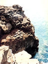
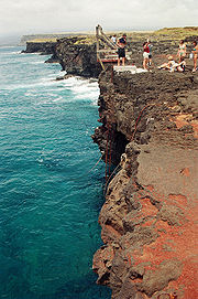
Ka Lae also known as South Point, is the southernmost point of the Big Island
of Hawaii
and of the 50 United States
. The Ka Lae area is registered as a National Historic Landmark District
under the name South Point Complex. The area is also known for its strong ocean currents and winds and is the home of a wind farm
.
comes from Ka Lae in the Hawaiian language
which means "the point".
It is often spelled as one word, Kalae, or called South Point or South Cape.
A confluence of ocean current
s just offshore makes this spot one of Hawaii's most popular fishing
spots. Both red snapper
and ulua
are plentiful here. Locals fish from the cliffs, some dangling perilously over the edge of steep lava
ledges. Swimming here, however, is not recommended, due to the current. In fact, it is called the "Halaea Current", named after a chief who was carried off to his death.
The confluence of currents also means the area is prone to accumulation of marine debris
. Most of this coastline is very remote and difficult to access, and is probably the most debris-littered coast in the state, primarily due to its difficult access for debris removal. This debris poses an entanglement threat to wildlife and may refloat during storms. The shoreline is used by Hawaiian Monk Seal
s and hatchling Hawksbill turtle
s, both endangered species
. Efforts to clean the coastline are organized by the Hawaii Wildlife Fund in conjunction with the NOAA
.
Ka Lae is accessible via South Point Road, a 20-mile (32 km) tarmac
road leading from State Route 11 (Hawaii Belt Road), the turn off being about 7 miles (11 km) west of the village of Nāālehu
and east of Ocean View, Hawaii. The strong winds cause some trees to become almost horizontal with their branches all growing in the same direction near the ground. The Kamaoa and Pakini Nui Wind Farms are located along the road, as well as the large shortwave radio antennas of World Harvest Radio International
which used callsign KWHR until 2009. A 13-meter parabolic antenna
of the Universal Space Network of the Swedish Space Corporation
. A fork is at the end of the tarmac road, with one dirt road leading to Ka Lae and the other to Papakolea Beach, known for its green sand.
, and it has one of the longest archaeological records on the islands. It is generally thought that this is where the Polynesia
ns first landed because the Big Island is the closest of the Hawaiian Islands
to Tahiti
, and Ka Lae would be the point of first landfall. Ruins of an ancient Hawaii
an temple (heiau
) and a fishing shrine can be found here. In addition, ancient Hawaiians drilled numerous holes in the rock ledges to use for mooring their canoes. Tying long ropes to their boats, they would drift out to sea to fish without fear of being carried away by the strong currents. Evidence suggests that people have been in the area since around A.D. 124. It was excavated by the Bishop Museum.
to build a house for a keeper. At the request of William Tufts Brigham
of the Bishop Museum, care was taken not to destroy the archaeological site. In 1929 a steel tower was built for the light, and in 1972 a new 32 foot (10m) concrete tower with solar power.
A NOAA Weather Radio
transmitter broadcasts weather reports from KBA99
with callsign WWG27 on 162.55 MHz.
A weather station also monitors wind speed.
, the US Air Force built a landing strip called Morse Field
on the point. After the war the airfield was closed in 1953.
In 1961 it was on the list of final sites to be considered by NASA
to launch manned rockets to space. However, it was considered too remote.
From 1964 to 1965 a space tracking station was operated, and in 1979 as a missile launching site.
The low latitude
of the location also made it (and nearby areas that are as remote) attractive as a site for private rocket launches, but these plans were dropped in the face of high costs and local opposition.
 In 1987 the Kamaoa Wind Farm began operation with thirty-seven Mitsubishi 250 kW
wind turbine
s with an operationally typical total peak output of 7.5 MW. By 2006 the turbines at 18°59′33"N 155°40′5"W were falling into disrepair, and they were finally shut down on August 15, 2006. At the end of August 2006, components for a new set of wind turbines were transported to South Point. The Pakini Nui project consists of 14 General Electric
wind turbines constructed at 18°58′20"N 155°41′21"W, about 1.5 miles (2.4 km) from the old Kamaoa wind farm. Completed in April 2007, Pakini Nui supplies up to 20.5 MW of power to the island electricity grid of Hawaii Electric Light Company. The wind farm is operated by Tawhiri Power, LLC. It is the southernmost wind farm in the United States.
Hawaii (island)
The Island of Hawaii, also called the Big Island or Hawaii Island , is a volcanic island in the North Pacific Ocean...
of Hawaii
Hawaii
Hawaii is the newest of the 50 U.S. states , and is the only U.S. state made up entirely of islands. It is the northernmost island group in Polynesia, occupying most of an archipelago in the central Pacific Ocean, southwest of the continental United States, southeast of Japan, and northeast of...
and of the 50 United States
Extreme points of the United States
This is a list of the extreme points of the United States, the points that are farther north, south, east, or west than any other location in the country. Also included are extreme points in elevation, extreme distances, and other points of peculiar geographic interest.-Northernmost:*Point Barrow,...
. The Ka Lae area is registered as a National Historic Landmark District
National Historic Landmark
A National Historic Landmark is a building, site, structure, object, or district, that is officially recognized by the United States government for its historical significance...
under the name South Point Complex. The area is also known for its strong ocean currents and winds and is the home of a wind farm
Wind farm
A wind farm is a group of wind turbines in the same location used to produce electric power. A large wind farm may consist of several hundred individual wind turbines, and cover an extended area of hundreds of square miles, but the land between the turbines may be used for agricultural or other...
.
Geography
The name for the southern tip of the island of HawaiiHawaii (island)
The Island of Hawaii, also called the Big Island or Hawaii Island , is a volcanic island in the North Pacific Ocean...
comes from Ka Lae in the Hawaiian language
Hawaiian language
The Hawaiian language is a Polynesian language that takes its name from Hawaii, the largest island in the tropical North Pacific archipelago where it developed. Hawaiian, along with English, is an official language of the state of Hawaii...
which means "the point".
It is often spelled as one word, Kalae, or called South Point or South Cape.
A confluence of ocean current
Ocean current
An ocean current is a continuous, directed movement of ocean water generated by the forces acting upon this mean flow, such as breaking waves, wind, Coriolis effect, cabbeling, temperature and salinity differences and tides caused by the gravitational pull of the Moon and the Sun...
s just offshore makes this spot one of Hawaii's most popular fishing
Fishing
Fishing is the activity of trying to catch wild fish. Fish are normally caught in the wild. Techniques for catching fish include hand gathering, spearing, netting, angling and trapping....
spots. Both red snapper
Red snapper (fish)
The red snapper, Lutjanus campechanus, is a fish found in the Gulf of Mexico and the southeastern Atlantic coast of the United States and, much less commonly, northward as far as Massachusetts. In Latin American Spanish it is known as huachinango or pargo...
and ulua
Giant trevally
The giant trevally, Caranx ignobilis , is a species of large marine fish classified in the jack family, Carangidae...
are plentiful here. Locals fish from the cliffs, some dangling perilously over the edge of steep lava
Lava
Lava refers both to molten rock expelled by a volcano during an eruption and the resulting rock after solidification and cooling. This molten rock is formed in the interior of some planets, including Earth, and some of their satellites. When first erupted from a volcanic vent, lava is a liquid at...
ledges. Swimming here, however, is not recommended, due to the current. In fact, it is called the "Halaea Current", named after a chief who was carried off to his death.
The confluence of currents also means the area is prone to accumulation of marine debris
Marine debris
Marine debris, also known as marine litter, is human created waste that has deliberately or accidentally become afloat in a lake, sea, ocean or waterway. Oceanic debris tends to accumulate at the centre of gyres and on coastlines, frequently washing aground, when it is known as beach litter or...
. Most of this coastline is very remote and difficult to access, and is probably the most debris-littered coast in the state, primarily due to its difficult access for debris removal. This debris poses an entanglement threat to wildlife and may refloat during storms. The shoreline is used by Hawaiian Monk Seal
Hawaiian Monk Seal
The Hawaiian monk seal, Monachus schauinslandi, is an endangered species of earless seal in the Phocidae family that is endemic to the Hawaiian Islands....
s and hatchling Hawksbill turtle
Hawksbill turtle
The hawksbill sea turtle is a critically endangered sea turtle belonging to the family Cheloniidae. It is the only extant species in its genus. The species has a worldwide distribution, with Atlantic and Pacific subspecies. E. imbricata imbricata is the Atlantic subspecies, while E...
s, both endangered species
Endangered species
An endangered species is a population of organisms which is at risk of becoming extinct because it is either few in numbers, or threatened by changing environmental or predation parameters...
. Efforts to clean the coastline are organized by the Hawaii Wildlife Fund in conjunction with the NOAA
National Oceanic and Atmospheric Administration
The National Oceanic and Atmospheric Administration , pronounced , like "noah", is a scientific agency within the United States Department of Commerce focused on the conditions of the oceans and the atmosphere...
.
Ka Lae is accessible via South Point Road, a 20-mile (32 km) tarmac
Tarmac
Tarmac is a type of road surface. Tarmac refers to a material patented by Edgar Purnell Hooley in 1901...
road leading from State Route 11 (Hawaii Belt Road), the turn off being about 7 miles (11 km) west of the village of Nāālehu
Na'alehu, Hawai'i
Naalehu is a census-designated place in Hawaii County, Hawaii. The population was 919 at the 2000 census. It is the southernmost town in the United States...
and east of Ocean View, Hawaii. The strong winds cause some trees to become almost horizontal with their branches all growing in the same direction near the ground. The Kamaoa and Pakini Nui Wind Farms are located along the road, as well as the large shortwave radio antennas of World Harvest Radio International
World Harvest Radio International
World Harvest Radio International is a shortwave radio station in the United States, broadcasting conservative religious programming worldwide in the English language on a number of frequencies...
which used callsign KWHR until 2009. A 13-meter parabolic antenna
Parabolic antenna
A parabolic antenna is an antenna that uses a parabolic reflector, a curved surface with the cross-sectional shape of a parabola, to direct the radio waves. The most common form is shaped like a dish and is popularly called a dish antenna or parabolic dish...
of the Universal Space Network of the Swedish Space Corporation
Swedish Space Corporation
The Swedish Space Corporation is a comprehensive space company covering the entire field, from the definition of innovative business concepts and space projects to the development, tests and operation of the systems....
. A fork is at the end of the tarmac road, with one dirt road leading to Ka Lae and the other to Papakolea Beach, known for its green sand.
South Point archaeological site
Ka Lae is the site of one of the earliest Hawaiian settlementsAncient Hawaii
Ancient Hawaii refers to the period of Hawaiian human history preceding the unification of the Kingdom of Hawaii by Kamehameha the Great in 1810. After being first settled by Polynesian long-distance navigators sometime between AD 300–800, a unique culture developed. Diversified agroforestry and...
, and it has one of the longest archaeological records on the islands. It is generally thought that this is where the Polynesia
Polynesia
Polynesia is a subregion of Oceania, made up of over 1,000 islands scattered over the central and southern Pacific Ocean. The indigenous people who inhabit the islands of Polynesia are termed Polynesians and they share many similar traits including language, culture and beliefs...
ns first landed because the Big Island is the closest of the Hawaiian Islands
Hawaiian Islands
The Hawaiian Islands are an archipelago of eight major islands, several atolls, numerous smaller islets, and undersea seamounts in the North Pacific Ocean, extending some 1,500 miles from the island of Hawaii in the south to northernmost Kure Atoll...
to Tahiti
Tahiti
Tahiti is the largest island in the Windward group of French Polynesia, located in the archipelago of the Society Islands in the southern Pacific Ocean. It is the economic, cultural and political centre of French Polynesia. The island was formed from volcanic activity and is high and mountainous...
, and Ka Lae would be the point of first landfall. Ruins of an ancient Hawaii
Ancient Hawaii
Ancient Hawaii refers to the period of Hawaiian human history preceding the unification of the Kingdom of Hawaii by Kamehameha the Great in 1810. After being first settled by Polynesian long-distance navigators sometime between AD 300–800, a unique culture developed. Diversified agroforestry and...
an temple (heiau
Heiau
A heiau is a Hawaiian temple. Many types of heiau existed, including heiau to treat the sick , offer first fruits, offer first catch, start rain, stop rain, increase the population, ensure health of the nation, achieve success in distant voyaging, reach peace, and achieve success in war . Only the...
) and a fishing shrine can be found here. In addition, ancient Hawaiians drilled numerous holes in the rock ledges to use for mooring their canoes. Tying long ropes to their boats, they would drift out to sea to fish without fear of being carried away by the strong currents. Evidence suggests that people have been in the area since around A.D. 124. It was excavated by the Bishop Museum.
Ka Lae light
On March 5, 1906 a small lighthouse opened at the point. In 1908 about 10 acres (4 ha) were set aside for the United States Coast GuardUnited States Coast Guard
The United States Coast Guard is a branch of the United States Armed Forces and one of the seven U.S. uniformed services. The Coast Guard is a maritime, military, multi-mission service unique among the military branches for having a maritime law enforcement mission and a federal regulatory agency...
to build a house for a keeper. At the request of William Tufts Brigham
William Tufts Brigham
William Tufts Brigham was an American geologist, botanist, ethnologist and the first director of the Bernice P. Bishop Museum in Honolulu.-Biography:...
of the Bishop Museum, care was taken not to destroy the archaeological site. In 1929 a steel tower was built for the light, and in 1972 a new 32 foot (10m) concrete tower with solar power.
A NOAA Weather Radio
NOAA Weather Radio All Hazards
NOAA Weather Radio All Hazards is a network of radio stations broadcasting continuous weather information directly from a nearby National Weather Service office. It is operated by the NWS, an agency of the National Oceanic and Atmospheric Administration within the United States Department of...
transmitter broadcasts weather reports from KBA99
KBA99
KBA99 is a NOAA Weather Radio station that is programmed from the National Weather Service forecast office in Honolulu, Hawaii with its transmitter located on Mt. Ka'ala in Oahu...
with callsign WWG27 on 162.55 MHz.
A weather station also monitors wind speed.
Recent history
During World War IIWorld War II
World War II, or the Second World War , was a global conflict lasting from 1939 to 1945, involving most of the world's nations—including all of the great powers—eventually forming two opposing military alliances: the Allies and the Axis...
, the US Air Force built a landing strip called Morse Field
Morse Field (Hawaii)
Morse Field is a former military airfield located approximately south-southwest of Naālehu, Hawaii. It was also known as South Cape Airport, South Point Air Force Station, or Ka Lae Military Reservation...
on the point. After the war the airfield was closed in 1953.
In 1961 it was on the list of final sites to be considered by NASA
NASA
The National Aeronautics and Space Administration is the agency of the United States government that is responsible for the nation's civilian space program and for aeronautics and aerospace research...
to launch manned rockets to space. However, it was considered too remote.
From 1964 to 1965 a space tracking station was operated, and in 1979 as a missile launching site.
The low latitude
Latitude
In geography, the latitude of a location on the Earth is the angular distance of that location south or north of the Equator. The latitude is an angle, and is usually measured in degrees . The equator has a latitude of 0°, the North pole has a latitude of 90° north , and the South pole has a...
of the location also made it (and nearby areas that are as remote) attractive as a site for private rocket launches, but these plans were dropped in the face of high costs and local opposition.
Watt
The watt is a derived unit of power in the International System of Units , named after the Scottish engineer James Watt . The unit, defined as one joule per second, measures the rate of energy conversion.-Definition:...
wind turbine
Wind turbine
A wind turbine is a device that converts kinetic energy from the wind into mechanical energy. If the mechanical energy is used to produce electricity, the device may be called a wind generator or wind charger. If the mechanical energy is used to drive machinery, such as for grinding grain or...
s with an operationally typical total peak output of 7.5 MW. By 2006 the turbines at 18°59′33"N 155°40′5"W were falling into disrepair, and they were finally shut down on August 15, 2006. At the end of August 2006, components for a new set of wind turbines were transported to South Point. The Pakini Nui project consists of 14 General Electric
General Electric
General Electric Company , or GE, is an American multinational conglomerate corporation incorporated in Schenectady, New York and headquartered in Fairfield, Connecticut, United States...
wind turbines constructed at 18°58′20"N 155°41′21"W, about 1.5 miles (2.4 km) from the old Kamaoa wind farm. Completed in April 2007, Pakini Nui supplies up to 20.5 MW of power to the island electricity grid of Hawaii Electric Light Company. The wind farm is operated by Tawhiri Power, LLC. It is the southernmost wind farm in the United States.