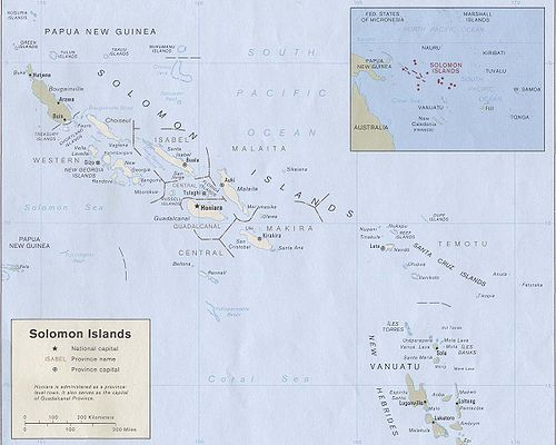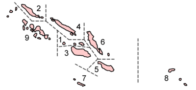
Provinces of the Solomon Islands
Encyclopedia


Solomon Islands
Solomon Islands is a sovereign state in Oceania, east of Papua New Guinea, consisting of nearly one thousand islands. It covers a land mass of . The capital, Honiara, is located on the island of Guadalcanal...
is currently divided into 9 province
Province
A province is a territorial unit, almost always an administrative division, within a country or state.-Etymology:The English word "province" is attested since about 1330 and derives from the 13th-century Old French "province," which itself comes from the Latin word "provincia," which referred to...
s. The national capital, Honiara
Honiara
Honiara, population 49,107 , 78,190 , is the capital of the Solomon Islands and of Guadalcanal Province, although it is a separately administered town...
, on the island of Guadalcanal
Guadalcanal
Guadalcanal is a tropical island in the South-Western Pacific. The largest island in the Solomons, it was discovered by the Spanish expedition of Alvaro de Mendaña in 1568...
, is separately governed as Capital Territory.
History
In the United KingdomUnited Kingdom
The United Kingdom of Great Britain and Northern IrelandIn the United Kingdom and Dependencies, other languages have been officially recognised as legitimate autochthonous languages under the European Charter for Regional or Minority Languages...
protectorate
Protectorate
In history, the term protectorate has two different meanings. In its earliest inception, which has been adopted by modern international law, it is an autonomous territory that is protected diplomatically or militarily against third parties by a stronger state or entity...
, there were initially 12 administrative districts: Choiseul, Eastern Solomons, Gizo, Guadalcanal, Lord Howe, Malaita, Nggela and Savo, Rennell and Bellona Islands, Santa Cruz, Shortlands, Sikaiana (Stewart), and Ysabel and Cape Marsh. The capital was Tulagi
Tulagi
Tulagi, less commonly Tulaghi, is a small island in the Solomon Islands, just off the south coast of Florida Island. The town of the same name on the island Tulagi, less commonly Tulaghi, is a small island (5.5 km by 1 km) in the Solomon Islands, just off the south coast of Florida...
.
After World War II
World War II
World War II, or the Second World War , was a global conflict lasting from 1939 to 1945, involving most of the world's nations—including all of the great powers—eventually forming two opposing military alliances: the Allies and the Axis...
, it was reorganized into four districts, Central, Western, Eastern, and Malalaita. These districts were then further subdivided into councils. The capital was also moved to Honiara
Honiara
Honiara, population 49,107 , 78,190 , is the capital of the Solomon Islands and of Guadalcanal Province, although it is a separately administered town...
. These were the political divisions that the nation inherited at its independence in 1978.
In 1981 the nation was reorganized into seven provinces by splitting some of the districts: Central District was split into Central, Guadalcanal, and Isabel provinces; Eastern District was split into Makira and Temotu provinces. The other two districts, Western and Malalaita, were also designated as provinces. These new provinces corresponded to the councils of the districts before 1981.
In 1983, the 22 square-kilometer Honiara
Honiara
Honiara, population 49,107 , 78,190 , is the capital of the Solomon Islands and of Guadalcanal Province, although it is a separately administered town...
was split off from Guadalcanal province and became a separately-governed Capital Territory. The city still serves as the capital of Guadalcanal province.
In 1995, Choiseul was split off from Western province, and Rennell and Bellona was split off from Central province, making the nine provinces of today.
Population
The population census data is from the 1999 census; the 2009 population estimates are those provided by the Solomon Islands National Statistics office. They show how the population has increased in the past decade for most of the provinces, especially the more urban ones, as urbanization grows. The figures for Guadalcanal Province do not include the separately-administered Capital Territory of HoniaraHoniara
Honiara, population 49,107 , 78,190 , is the capital of the Solomon Islands and of Guadalcanal Province, although it is a separately administered town...
; if included, that province would have had a total population of 109,382 in 1999, when it was the second largest province; by 2009, the combined estimate for Guadalcanal and the Capital Territory would be 157,745, making it the largest province. The Capital Territory is ranked as n/a below, and does not count in the order.
Table of Provinces
| # | Province !! Capital !! Area (km²) !! Population census Census A census is the procedure of systematically acquiring and recording information about the members of a given population. It is a regularly occurring and official count of a particular population. The term is used mostly in connection with national population and housing censuses; other common... 1999 !! Population per km² (1999) !! Population estimate 2009 |
|||||
|---|---|---|---|---|---|---|
| 1 | Central Province Central Province (Solomon Islands) The Central Province is one of the provinces of the Solomon Islands, covering the Russell Islands, Nggela Islands and Savo Island. Its area comprises 615 km² and had a population of 21,577 as of 1999. The capital is Tulagi.-Islands:*Aeaun... |
Tulagi Tulagi Tulagi, less commonly Tulaghi, is a small island in the Solomon Islands, just off the south coast of Florida Island. The town of the same name on the island Tulagi, less commonly Tulaghi, is a small island (5.5 km by 1 km) in the Solomon Islands, just off the south coast of Florida... |
615 | 21,577 | 35.1 | 24,226 |
| 2 | Choiseul Province Choiseul Province The Choiseul Province is one of the nine provinces of the Solomon Islands. It lies between the island of Bougainville and Santa Isabel in the west of the Solomon Islands.... |
Taro Island Taro Island Taro Island is a small island in the Solomon Islands with 507 inhabitants, capital of Choiseul Province and is located in Choiseul Bay off the northwest coast.... |
3,837 | 20,008 | 5.2 | 24,060 |
| 3 | Guadalcanal Province Guadalcanal Province Guadalcanal Province is one of the provinces of the Solomon Islands, consisting of the island of Guadalcanal. It is a 2,510 square mile island and is largely a jungle. Its name was given by Pedro de Ortega Valencia, born in the village of Guadalcanal in Seville, Spain... (1) |
Honiara Honiara Honiara, population 49,107 , 78,190 , is the capital of the Solomon Islands and of Guadalcanal Province, although it is a separately administered town... |
5,336 | 60,275 | 11.3 | 79,555 |
| 4 | Isabel Province Isabel Province Isabel Province is one of the provinces of the Solomon Islands. It has a population of around 30,000 . The capital is Buala on Santa Isabel Island.Santa Isabel is the longest Island in the Solomon Islands, South Pacific... |
Buala Buala Buala is a town in the Solomon Islands.Buala is located on Santa Isabel Island . Buala consists of Jejevo station and Buala Village. Buala is located on a side of a hill so there is no place for the town to expand, therefore there is still no road in that township. Kubolota, Tithiro, and Maglau are... |
4,136 | 20,421 | 4.9 | 23,209 |
| 5 | Makira-Ulawa Province Makira-Ulawa Province Makira-Ulawa Province is one of the provinces of the Solomon Islands. The main part of the province is Makira Island. It has a population of 31,006... |
Kirakira Kirakira Kirakira the provincial capital of the Makira-Ulawa Province in the Solomon Islands. Kirakira is located on the north coast of Makira , the largest island of the province. It has roads running east to the Warihito River and west to Maro'u Bay.The Kirakira Airport is served by Solomon Airlines,... |
3,188 | 31,006 | 9.7 | 38,123 |
| 6 | Malaita Province Malaita Province Malaita Province is one of the largest provinces of the Solomon Islands. It is named for its largest island, Malaita . Other islands include South Malaita Island , Sikaiana Island, and Ontong Java Atoll. The provincial capital and largest urban center is Auki, located on Big Malaita... |
Auki Auki Auki is the provincial capital of Malaita Province, Solomon Islands. It is situated on the northern end of Langalanga Lagoon on the north-west coast of Malaita Island. There are daily flights between the Solomons capital of Honiara and Auki... |
4,225 | 122,620 | 29.0 | 143,852 |
| 7 | Rennell and Bellona Province | Tigoa Tigoa Tigoa is a village in the Solomon Islands, on Rennell Island. It is the capital of Rennell and Bellona province. It is located approximately 40–60 ft above sea level.... |
671 | 2,377 | 3.5 | 2,174 |
| 8 | Temotu Province Temotu Province Temotu is the easternmost province of the Solomon Islands. The province was formerly known as Santa Cruz Islands Province. It consists, essentially, of two chains of islands which run parallel to each other from the northwest to the southeast.- Islands :... |
Lata Lata, Solomon Islands Lata is the provincial capital of Temotu Province, Solomon Islands. As of 2007, it has 553 inhabitants. There are a few rest houses for over night stays. There is a Post office, Telecom office and numerous stores.... |
895 | 18,912 | 21.1 | 21,190 |
| 9 | Western Province Western Province (Solomon Islands) Western Province is the largest of the provinces of the Solomon Islands. The area is renowned for its beautiful tropical islands, excellent diving and snorkelling, coral reefs and WWII wrecks, ecotourism lodges, and head-hunting shrines... |
Gizo | 5,475 | 62,739 | 11.5 | 83,759 |
| n/a | Capital Territory Honiara Honiara, population 49,107 , 78,190 , is the capital of the Solomon Islands and of Guadalcanal Province, although it is a separately administered town... |
Honiara Honiara Honiara, population 49,107 , 78,190 , is the capital of the Solomon Islands and of Guadalcanal Province, although it is a separately administered town... |
22 | 49,107 | 2,232.1 | 78,190 |
| Solomon Islands Solomon Islands Solomon Islands is a sovereign state in Oceania, east of Papua New Guinea, consisting of nearly one thousand islands. It covers a land mass of . The capital, Honiara, is located on the island of Guadalcanal... |
Honiara Honiara Honiara, population 49,107 , 78,190 , is the capital of the Solomon Islands and of Guadalcanal Province, although it is a separately administered town... |
28,400 | 409,042 | 14.4 | 518,338 |
(1) excluding the Capital Territory of Honiara
See also
- ISO 3166-2:SBISO 3166-2:SBISO 3166-2:SB is the entry for the Solomon Islands in ISO 3166-2, part of the ISO 3166 standard published by the International Organization for Standardization , which defines codes for the names of the principal subdivisions of all countries coded in ISO 3166-1.Currently for the Solomon Islands,...

