Cape Flattery, Washington
Encyclopedia
Cape Flattery is the northwesternmost point of the contiguous United States
. It is in Clallam County, Washington on the Olympic Peninsula
, where the Strait of Juan de Fuca
joins the Pacific Ocean
. It is also part of the Makah Reservation
, and is the northern boundary of the Olympic Coast National Marine Sanctuary
. Cape Flattery can be reached from a short hike, most of which is boardwalked. The westernmost point in the contiguous United States is at Cape Alava
, south of Cape Flattery in Olympic National Park
. However, the westernmost tip of Cape Flattery is almost exactly as far west as Cape Alava, the difference being approximately 5 seconds of longitude, about 360 feet (109.7 m), at high tide and somewhat more at low tide.
The Cape Flattery Lighthouse
is on Tatoosh Island, just off the cape. Makah Bay and Neah Bay are on either side of the cape. Neah Bay, Washington
is the closest town to the cape.
on March 22, 1778. Cook wrote: "... there appeared to be a small opening which flattered us with the hopes of finding an harbour ... On this account I called the point of land to the north of it Cape Flattery."
by William H. McNeill under orders from John McLoughlin
.
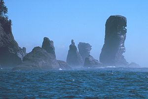
 Fuca Pillar is a tall, almost rectangular, rock on the west side of Cape Flattery. It is named after Juan de Fuca
, a Greek sailor who explored for Spain. Fuca has a doubtful claim to being the first European explorer to see the Fuca Pillar and to explore the Strait of Juan de Fuca
, also named for him. The first generally accepted mention of the pillar was by John Meares
in 1788.
by Joyce Carol Oates
are set here in present day.
Contiguous United States
The contiguous United States are the 48 U.S. states on the continent of North America that are south of Canada and north of Mexico, plus the District of Columbia....
. It is in Clallam County, Washington on the Olympic Peninsula
Olympic Peninsula
The Olympic Peninsula is the large arm of land in western Washington state of the USA, that lies across Puget Sound from Seattle. It is bounded on the west by the Pacific Ocean, the north by the Strait of Juan de Fuca, and the east by Puget Sound. Cape Alava, the westernmost point in the contiguous...
, where the Strait of Juan de Fuca
Strait of Juan de Fuca
The Strait of Juan de Fuca is a large body of water about long that is the Salish Sea outlet to the Pacific Ocean...
joins the Pacific Ocean
Pacific Ocean
The Pacific Ocean is the largest of the Earth's oceanic divisions. It extends from the Arctic in the north to the Southern Ocean in the south, bounded by Asia and Australia in the west, and the Americas in the east.At 165.2 million square kilometres in area, this largest division of the World...
. It is also part of the Makah Reservation
Makah Reservation
Makah Reservation is an Indian reservation for the Makah located on the most northwestern tip of the Olympic Peninsula in Clallam County, Washington, USA. The northern boundary of the reservation is the Strait of Juan de Fuca. The western boundary is the Pacific Ocean. It has a land area of and a...
, and is the northern boundary of the Olympic Coast National Marine Sanctuary
Olympic Coast National Marine Sanctuary
The Olympic Coast National Marine Sanctuary is one of 14 marine sanctuaries administered by the National Oceanic and Atmospheric Administration , an agency of the U.S. Department of Commerce. It is located along the Olympic Peninsula of Washington state...
. Cape Flattery can be reached from a short hike, most of which is boardwalked. The westernmost point in the contiguous United States is at Cape Alava
Cape Alava
Cape Alava, in Clallam County, Washington, U.S.A., is the westernmost point in the contiguous 48 states, with a longitude of . The westernmost point is located in Olympic National Park and the Ozette Indian Reservation...
, south of Cape Flattery in Olympic National Park
Olympic National Park
Olympic National Park is located in the U.S. state of Washington, in the Olympic Peninsula. The park can be divided into four basic regions: the Pacific coastline, alpine areas, the west side temperate rainforest and the forests of the drier east side. U.S...
. However, the westernmost tip of Cape Flattery is almost exactly as far west as Cape Alava, the difference being approximately 5 seconds of longitude, about 360 feet (109.7 m), at high tide and somewhat more at low tide.
The Cape Flattery Lighthouse
Cape Flattery Lighthouse
Cape Flattery Lighthouse was built in 1854 based on the design by Ammi B. Young. Its first light was displayed from a first-order lens in 1857 and was Washington Territory's third lighthouse. The house with a 65 foot tower from the center still stands. A fog signal building with a 12-inch steam...
is on Tatoosh Island, just off the cape. Makah Bay and Neah Bay are on either side of the cape. Neah Bay, Washington
Neah Bay, Washington
Neah Bay is a census-designated place on the Makah Indian reservation in Clallam County, Washington, United States. The population was 794 at the 2000 census.-Geography:Neah Bay is located at ....
is the closest town to the cape.
James Cook
Cape Flattery is the oldest permanently named feature in Washington state, being described and named by James CookJames Cook
Captain James Cook, FRS, RN was a British explorer, navigator and cartographer who ultimately rose to the rank of captain in the Royal Navy...
on March 22, 1778. Cook wrote: "... there appeared to be a small opening which flattered us with the hopes of finding an harbour ... On this account I called the point of land to the north of it Cape Flattery."
Japanese castaways in 1834
In 1834, the first Japanese known to have arrived in what is now Washington state arrived in a dismasted, rudderless ship that ran aground near Cape Flattery. The three survivors of the broken ship were held as slaves by the local Makah people before being taken to Fort VancouverFort Vancouver
Fort Vancouver was a 19th century fur trading outpost along the Columbia River that served as the headquarters of the Hudson's Bay Company in the company's Columbia District...
by William H. McNeill under orders from John McLoughlin
John McLoughlin
Dr. John McLoughlin, baptized Jean-Baptiste McLoughlin, was the Chief Factor of the Columbia Fur District of the Hudson's Bay Company at Fort Vancouver. He was later known as the "Father of Oregon" for his role in assisting the American cause in the Oregon Country in the Pacific Northwest...
.
Fuca Pillar

Juan de Fuca
Ioánnis Fokás , better known by the Spanish transcription of his name, Juan de Fuca , was a Greek-born maritime pilot in the service of the king of Spain, Philip II...
, a Greek sailor who explored for Spain. Fuca has a doubtful claim to being the first European explorer to see the Fuca Pillar and to explore the Strait of Juan de Fuca
Strait of Juan de Fuca
The Strait of Juan de Fuca is a large body of water about long that is the Salish Sea outlet to the Pacific Ocean...
, also named for him. The first generally accepted mention of the pillar was by John Meares
John Meares
John Meares was a navigator, explorer, and maritime fur trader, best known for his role in the Nootka Crisis, which brought Britain and Spain to the brink of war.- Career :...
in 1788.
Literary references
The novel When Wolf Comes by John Pappas is set in Cape Flattery in 1801. Parts of the novel Freaky Green EyesFreaky Green Eyes
For the Fourth of July, Franky and Samantha go with their father to Cape Flattery to stay with one of his friends. While there, Franky learns that Reid's friend's sons steal animals from a wildlife refuge and put them in cages to make their own zoo. In the middle of the night, Franky releases all...
by Joyce Carol Oates
Joyce Carol Oates
Joyce Carol Oates is an American author. Oates published her first book in 1963 and has since published over fifty novels, as well as many volumes of short stories, poetry, and nonfiction...
are set here in present day.

