

Iron Cove Creek
Encyclopedia
Canal
Canals are man-made channels for water. There are two types of canal:#Waterways: navigable transportation canals used for carrying ships and boats shipping goods and conveying people, further subdivided into two kinds:...
) in Sydney
Sydney
Sydney is the most populous city in Australia and the state capital of New South Wales. Sydney is located on Australia's south-east coast of the Tasman Sea. As of June 2010, the greater metropolitan area had an approximate population of 4.6 million people...
, in the state of New South Wales
New South Wales
New South Wales is a state of :Australia, located in the east of the country. It is bordered by Queensland, Victoria and South Australia to the north, south and west respectively. To the east, the state is bordered by the Tasman Sea, which forms part of the Pacific Ocean. New South Wales...
, Australia
Australia
Australia , officially the Commonwealth of Australia, is a country in the Southern Hemisphere comprising the mainland of the Australian continent, the island of Tasmania, and numerous smaller islands in the Indian and Pacific Oceans. It is the world's sixth-largest country by total area...
. It is located in the inner-western
Inner West (Sydney)
The Inner West is a general term which is used to describe the metropolitan area directly to the west of the Sydney central business district, New South Wales, Australia...
suburbs of Croydon
Croydon, New South Wales
Croydon is an affluent suburb in the inner-west of Sydney, in the state of New South Wales, Australia. Croydon is located 11 kilometres west of the Sydney central business district. Croydon is split between the two local government areas of Burwood Council and the Municipality of Ashfield.The...
, Ashfield
Ashfield, New South Wales
Ashfield is a suburb in the inner-west of Sydney, in the state of New South Wales, Australia. Ashfield is about 9 kilometres south-west of the Sydney central business district and is the administrative centre for the local government area of the Municipality of Ashfield.The official name for the...
, Haberfield
Haberfield, New South Wales
Haberfield is a suburb in the inner-west of Sydney, in the state of New South Wales, Australia. Haberfield is located 9 kilometres west of the Sydney central business district in the local government area of the Municipality of Ashfield....
and Five Dock
Five Dock, New South Wales
Five Dock is a suburb in the inner-west of Sydney, in the state of New South Wales, Australia. Five Dock is located 10 kilometres west of the Sydney central business district, in the Local Government Area of the City of Canada Bay.-Location:...
. Iron Cove Creek traverses mostly through residential areas and parkland, making a two kilometre journey from where it surfaces in Croydon
Croydon, New South Wales
Croydon is an affluent suburb in the inner-west of Sydney, in the state of New South Wales, Australia. Croydon is located 11 kilometres west of the Sydney central business district. Croydon is split between the two local government areas of Burwood Council and the Municipality of Ashfield.The...
to where it empties into Iron Cove, which is a bay of the Parramatta River
Parramatta River
The Parramatta River is a waterway in Sydney, New South Wales, Australia. The Parramatta River is the main tributary of Sydney Harbour, a branch of Port Jackson, along with the smaller Lane Cove and Duck Rivers....
, at Five Dock
Five Dock, New South Wales
Five Dock is a suburb in the inner-west of Sydney, in the state of New South Wales, Australia. Five Dock is located 10 kilometres west of the Sydney central business district, in the Local Government Area of the City of Canada Bay.-Location:...
. It also forms much of the border between Croydon and Ashfield upstream from Parramatta Road
Parramatta Road
.Parramatta Road is the major historical east-west artery of metropolitan Sydney, Australia, connecting the Sydney with Parramatta. It is the eastern-most part of the Great Western Highway. Much of its traffic has been diverted to modern expressways such as the M4 and the City West Link...
.
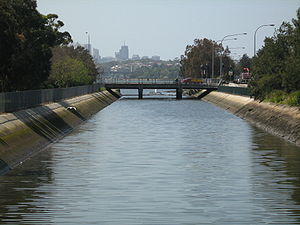
Once a natural watercourse abound with native vegetation and wildlife, Iron Cove Creek was transformed in the late 19th century into a stormwater channel that drains a fairly large catchment area in Sydney's inner-western suburbs.
History

Snake
Snakes are elongate, legless, carnivorous reptiles of the suborder Serpentes that can be distinguished from legless lizards by their lack of eyelids and external ears. Like all squamates, snakes are ectothermic, amniote vertebrates covered in overlapping scales...
s were abundant in this area and these, like the possum
Possum
A possum is any of about 70 small to medium-sized arboreal marsupial species native to Australia, New Guinea, and Sulawesi .Possums are quadrupedal diprotodont marsupials with long tails...
s and gliders
Flying and gliding animals
A number of animals have evolved aerial locomotion, either by powered flight or by gliding. Flying and gliding animals have evolved separately many times, without any single ancestor. Flight has evolved at least four times, in the insects, pterosaurs, birds, and bats. Gliding has evolved on many...
that inhabited the treetops, often fell victim to the predations of children with improvised bows and arrows and slingshots and their elders armed with more sophisticated weapons.
During the 1890s the character and appearance of Iron Cove Creek was dramatically altered. As early as 1880 Iron Cove Creek was perceived to present hazards both to the health and convenience of the local community; it tended to flood in heavy rain and to become stagnant during dry weather and, with the sanitary conditions that then prevailed, was a source of typhoid fever
Typhoid fever
Typhoid fever, also known as Typhoid, is a common worldwide bacterial disease, transmitted by the ingestion of food or water contaminated with the feces of an infected person, which contain the bacterium Salmonella enterica, serovar Typhi...
. Plans were made to concrete its banks, but major work did not commence until 1891. The construction of the banks was carried out by the Department of Public Works and was supervised by a local resident, William Best Chessell. It took five years and had a profound effect on the appearance and future development of Croydon. In his book Between Two Highways: the story of early Croydon, Eric Dunlop points out that as a result of the construction of canals and tunnels:
Present Course

Stormwater
Stormwater is water that originates during precipitation events. It may also be used to apply to water that originates with snowmelt that enters the stormwater system...
tunnel finally exiting into daylight. From here, it makes its way through a cement cutting only a few metres wide with high concrete walls on either side and passes under the Inner West railway line. From here until Parramatta Road
Parramatta Road
.Parramatta Road is the major historical east-west artery of metropolitan Sydney, Australia, connecting the Sydney with Parramatta. It is the eastern-most part of the Great Western Highway. Much of its traffic has been diverted to modern expressways such as the M4 and the City West Link...
it remains just a small trickle during dry weather. The canal is bounded by the fences of commercial and residential properties as well as a barbed wire fence along Etonville Parade, and is for the most part hidden from the public eye. The creek's character does not change until it reaches the John Street bridge where the concreted channel widens significantly and the height of the banks drops about threefold. From John Street to West Street, Iron Cove Creek is flanked by a wide grass verge covered with various types of vegetation leaving potential for a recreational walking/cycling path beside the creek. There is also ample space for bush regeneration to take place by the planting of indigenous species. About 100 metres downstream from West Street is the Parramatta Road bridge, which marks the approximate tidal limit of the creek. Adjacent to the creek on Parramatta Road are popular fast-food restaurants
Fast food restaurant
A fast food restaurant, also known as a Quick Service Restaurant or QSR within the industry itself, is a specific type of restaurant characterized both by its fast food cuisine and by minimal table service...
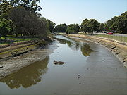
, a council depot and a service station. After flowing under the Parramatta Road bridge, Iron Cove Creek finally enters public parkland and becomes a broad channel probably similar to the width of the original channel. On the right is parkland and running parallel to the creek on the left bank of is Henley Marine Drive. Iron Cove Creek then passes beneath Ramsay Street, widens further, and proceeds through parkland including Timbrell Park. The creek is very tidal here and the water level difference between low and high tide is significant. Mullet
Mullet (fish)
The mullets or grey mullets are a family and order of ray-finned fish found worldwide in coastal temperate and tropical waters, and in some species in fresh water. Mullets have served as an important source of food in Mediterranean Europe since Roman times...
may also be seen in the lower reaches of Iron Cove Creek below Parramatta Road at high tide. The creek empties into Iron Cove as a broad canal at the intersection of Timbrell Drive and Dobroyd Parade
City West Link Road
City West Link Road is a link road in Sydney, Australia. It makes up a section of Metroad 4 between Leichhardt, Haberfield and Five Dock. As such, it provides an alternative route to Parramatta Road into Sydney's CBD from the Inner-West....
at Five Dock, where there is a floating boom across the creek that is designed to stop pollution
Pollution
Pollution is the introduction of contaminants into a natural environment that causes instability, disorder, harm or discomfort to the ecosystem i.e. physical systems or living organisms. Pollution can take the form of chemical substances or energy, such as noise, heat or light...
entering Port Jackson
Port Jackson
Port Jackson, containing Sydney Harbour, is the natural harbour of Sydney, Australia. It is known for its beauty, and in particular, as the location of the Sydney Opera House and Sydney Harbour Bridge...
. Between Parramatta Road and Iron Cove, Iron Cove Creek forms part of the border between the federal electoral divisions of Reid
Division of Reid
The Division of Reid is an Australian Electoral Division in the state of New South Wales. It is located in the western suburbs of Sydney, and includes the suburbs of Abbotsford, Auburn , Berala , Breakfast Point, Burwood , Cabarita, Canada Bay, Chiswick, Concord, Concord West, Croydon , Drummoyne,...
and Grayndler
Division of Grayndler
The Division of Grayndler is an Australian Electoral Division in inner Metropolitan Sydney, New South Wales. It is one of Australia's smallest electorates, located in the inner-southern Sydney metropolitan area, including parts of the inner-west...
following a 2009 redistribution.
Church Street Bridge
The Church Street bridge spans Iron Cove Creek on the border of the inner-westernInner West (Sydney)
The Inner West is a general term which is used to describe the metropolitan area directly to the west of the Sydney central business district, New South Wales, Australia...
suburbs of Croydon
Croydon, New South Wales
Croydon is an affluent suburb in the inner-west of Sydney, in the state of New South Wales, Australia. Croydon is located 11 kilometres west of the Sydney central business district. Croydon is split between the two local government areas of Burwood Council and the Municipality of Ashfield.The...
and Ashfield
Ashfield, New South Wales
Ashfield is a suburb in the inner-west of Sydney, in the state of New South Wales, Australia. Ashfield is about 9 kilometres south-west of the Sydney central business district and is the administrative centre for the local government area of the Municipality of Ashfield.The official name for the...
. The bridge is built of sandstone, brick, and steel. The course of Church Street was originally defined by the track used by Burwood residents to attend St John's Ashfield, who crossed the Creek at a conveniently-located large fallen tree.
Pollution
Parramatta Road
.Parramatta Road is the major historical east-west artery of metropolitan Sydney, Australia, connecting the Sydney with Parramatta. It is the eastern-most part of the Great Western Highway. Much of its traffic has been diverted to modern expressways such as the M4 and the City West Link...
. Also, the concrete lining of the creek prevents the growth of natural vegetation such as mangrove
Mangrove
Mangroves are various kinds of trees up to medium height and shrubs that grow in saline coastal sediment habitats in the tropics and subtropics – mainly between latitudes N and S...
s which assist in maintaining water quality.
Iron Cove Creek supplies water and sediment enriched in copper
Copper
Copper is a chemical element with the symbol Cu and atomic number 29. It is a ductile metal with very high thermal and electrical conductivity. Pure copper is soft and malleable; an exposed surface has a reddish-orange tarnish...
, lead
Lead
Lead is a main-group element in the carbon group with the symbol Pb and atomic number 82. Lead is a soft, malleable poor metal. It is also counted as one of the heavy metals. Metallic lead has a bluish-white color after being freshly cut, but it soon tarnishes to a dull grayish color when exposed...
and zinc
Zinc
Zinc , or spelter , is a metallic chemical element; it has the symbol Zn and atomic number 30. It is the first element in group 12 of the periodic table. Zinc is, in some respects, chemically similar to magnesium, because its ion is of similar size and its only common oxidation state is +2...
to the Iron Cove under low flow conditions and is a major source of contaminants. Increasing salinity in the lower sections of Iron Cove Creek largely controls partitioning between the particulate and dissolved phases of copper, lead and zinc. Contaminant loading to Iron Cove may be contingent on extended periods of low flow rather than high flow events during which contaminated material is rapidly exported from the estuary in a discrete surface layer. This unusual characteristic offers attractive possibilities for remediation of stormwater entering Port Jackson
Port Jackson
Port Jackson, containing Sydney Harbour, is the natural harbour of Sydney, Australia. It is known for its beauty, and in particular, as the location of the Sydney Opera House and Sydney Harbour Bridge...
.
External links
- Sydney Water page on Iron Cove Creek (Dobroyd Stormwater Channel)
- Historical photographs of Iron Cove Creek from the State Library of New South Wales can be viewed here
- Iron Cove Creek at NSW Geographical Names Board
- Iron Cove Creek Bridge - Roads and Traffic Authority
- Dobroyd Stormwater Channel (Iron Cove Creek) at Aussie Heritage