
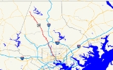
Maryland Route 25
Encyclopedia
Maryland Route 25 locally known for nearly its entire length as Falls Road, is a state highway
in the U.S. state
of Maryland
. It begins north of downtown Baltimore
, just north of Penn Station, and continues north through Baltimore County
almost to the Pennsylvania
state line. The road passes through the communities of Hampden, Medfield
, Cross Keys, and Mount Washington in the city, and Brooklandville
and Butler
in Baltimore County. The entire length of MD 25 that uses Falls Road–and its locally maintained continuation north to Alesia
–is a Maryland Scenic Byway, named "Falls Road".
on Lafayette Avenue (westbound, carrying MD 25 north) and Lanvale Street (eastbound, carrying MD 25 south) north of Penn Station. The route starts at MD 2
northbound (Calvert Street
), crossing southbound MD 2 (St. Paul Street
) one block west. After crossing Maryland Avenue, the two directions join and the road curves to the northwest, becoming Falls Road.
From its beginning to Hampden, Falls Road runs through the valley of Jones Falls
, which is shared with the Jones Falls Expressway (I-83), Central Light Rail Line (former Northern Central Branch of the Pennsylvania Railroad
), a small piece of the CSX Baltimore Terminal Subdivision, and the abandoned Maryland and Pennsylvania Railroad
right-of-way (now partly used by the Baltimore Streetcar Museum
). The only intersections on this portion, other than driveways, are with Chestnut Avenue and Clipper Mill Road (the latter where Falls Road leaves the valley); it passes underneath the bridges that Howard Street
, North Avenue, 28th Street, 29th Street, and Wyman Park Drive use to cross the valley.
As it climbs from the valley into Hampden, Falls Road meets the ramps from exit 8 of the Jones Falls Expressway. These ramps only allow access from the JFX north to Falls Road north and Falls Road south to the JFX south; other movements can be made to the north at Cold Spring Lane. As it passes through Hampden, Medfield, and Cross Keys, Falls Road is relatively flat and straight, gradually sloping down to return to Jones Falls near Mount Washington, north of Northern Parkway
(ranked in 2001 by State Farm Insurance
as the most dangerous intersection in the state, based on the number of accidents that have occurred at the location). After leaving the city, a northwesterly climb and descent through Bare Hills (past the Falls Road Animal Hospital and Robert E. Lee Park, which contains Lake Roland
) returns Falls Road to the valley for the final time, passing under the JFX, through Rockland (where it intersects Old Court Road/Ruxton Road, carrying MD 133 to the west), over the Baltimore Beltway (I-695), and past the Cloisters to the north end of the JFX (MD 25A here) at Joppa Road
in Brooklandville
. Since the JFX was built, it has fed directly into Falls Road to the north; traffic remaining on Falls Road must turn. Here Jones Falls turns west through the Green Spring Valley, but Falls Road continues northward. Just beyond are the east end of MD 130 (Greenspring Valley Road) and the west end of MD 131 (Seminary Avenue).
After Brooklandville, the road continues in a general north-northwesterly direction, up hills and down valleys. It passes a number of settlements, including Shawan, Butler
(MD 128 west), Coopersville (former MD 401 east and MD 88
west), and Whitehouse (MD 137). When it reaches Beckleysville Road, between Albantown and Beckleysville, state maintenance (and hence MD 25) ends, while Falls Road (formerly Linesboro Valley Road) continues to Alesia
as a paved road and scenic byway. Beyond Alesia to the end at Schalk Road Number 1 near Gunpowder Falls, Falls Road is a dirt road.
and light rail
services operated by the Maryland Transit Administration
. The Light Rail, using the right-of-way formerly used by the Pennsylvania Railroad
's Northern Central Branch, is at most about 1/2 mile (1 km) from Falls Road within the city. Most of Falls Road here is directly served by the Route 27 bus, which turns off at Kelly Avenue in Mount Washington near the northern city limits; Route 60
continues north into Baltimore County to Brooklandville
.
The Route 27 bus is the successor to the No. 25 Mount Washington Line trolley, which was opened on October 17, 1897 by the Pimlico and Pikesville Railroad from downtown to Pikesville
, including tracks on Falls Road south of Kelly Avenue. The line was soon taken off Falls Road south of 36th Street, in order to serve Hampden and other populated parts of the city better, as Route 27 still does. Trolleys were replaced with buses on April 24, 1949. The number 25 is now assigned to the Baltimore Streetcar Museum
, running on former Maryland and Pennsylvania Railroad
right-of-way just east of Falls Road.
 On the December 27, 1791, the Maryland General Assembly authorized Elisha Tyson, William & Charles Jessop, John Ellicott, George Leggett, Robert Long, Jacob Hart, and John Stricker to lay out a road, not to exceed 40 feet (12.2 m) wide, from their flour mill-seats on Jones Falls, then in Baltimore County, southerly to Baltimore Town, thereafter known as the Falls Road. [20] On January 19, 1805, A company known as 'The President, Managers and Company, of the Falls Turnpike Road', more commonly called the 'Falls Turnpike', was incorporated
and charter
ed by the Maryland General Assembly
. The company was authorized to build and operate a turnpike road "for the accommodation of the inhabitants on Jones's Falls
, and the country adjacent", running from "the ford by Messieurs [William] Patterson and [John] Stricker's mill" northerly to "the cross roads by the limekiln of Richard Caton" (Brooklandville
). Construction was to begin within two years and finish within five. (Completion was extended to January 1, 1813 by the General Assembly on December 23, 1808.) The law included a statement that "it would be unjust and improper to extend the said turnpike so as to make the same intersect the York-town turnpike...drawing off from said road any portion of the trade that now passes down the said road into Old-town, in the city of Baltimore", but allowed the Falls Turnpike to extend south to the York-town Turnpike (Greenmount Avenue) "at or near a stone bridge opposite the old mill of Josiah Pennington" (Belvidere Street across Jones Falls, just south of Hoffman Street and east of Barclay Street) with the consent of that company. A law passed January 25, 1806 allowed the company to build this extension without the approval of the York-town Turnpike. On December 28, 1812, the General Assembly "confirmed and established" the completed roadway.
According to Richard Caton, whose limekiln
was located near the north end of the turnpike, and who was one of the officers of the company, the turnpike was "excepted to unite the trade of the North with Baltimore...in a direct line to Hanover and Carlisle." This extension was delayed by what Caton thought was a desire to keep the Baltimore and Reister's-town Turnpike's monopoly
. A public road extending from Brooklandville north-northwesterly to George Kerlinger's Mill on Gunpowder Falls - near but not on the Pennsylvania
state line - was authorized by a state law passed December 24, 1808. The Falls Turnpike began building the road, but lacked funds to complete it, and another law passed January 15, 1817 allowed the company to increase their capitalization
and to charge tolls for travel on the extension. On March 12, 1828, the General Assembly ordered the company to, within six months, return this extension to the county for use as a free public road, and the turnpike was thus cut back to Brooklandville.
The turnpike began at the intersection of Cathedral Street
and Howard Street
(now the diagonal portion of Chase Street, intersecting Cathedral Street about half a block south of Biddle Street). It proceeded north on Cathedral Street, crossing Jones Falls a bit north of North Avenue to the current Falls Road. After North Avenue was built, the turnpike was separated from Cathedral Avenue, ending at North Avenue east of Jones Falls.
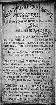
The description of allowed rates of toll
given in the legislative charter are lengthy, and specify that, for instance, a horse and rider shall be charged 6.25 cents, and a two-horse stagecoach
25 cents, for the entire distance, and a smaller amount in proportion to the distance traveled. Five miles were completed by 1811, allowing the company to erect a toll gate; a second gate had been placed by 1819. Due to the impossibility of determining how far a customer had traveled, the Baltimore County Court allowed the company to charge a full toll for passing over any part of the road. The southern toll gate was located one to two blocks north of North Avenue at the bridge over Jones Falls, and the other was several miles north, near Cross Keys.
The road was sold to the state and tolls were eliminated between 1899 and 1910, and the state acquired the extension to Beckleysville Road from the county. The number 25 was assigned in the late 1920s, when the first Maryland Routes were given numbers.
In 1928, the intersection of Falls Road and Belvedere Avenue (now Northern Parkway
was the location of the first modern traffic light
.
State highway
State highway, state road or state route can refer to one of three related concepts, two of them related to a state or provincial government in a country that is divided into states or provinces :#A...
in the U.S. state
U.S. state
A U.S. state is any one of the 50 federated states of the United States of America that share sovereignty with the federal government. Because of this shared sovereignty, an American is a citizen both of the federal entity and of his or her state of domicile. Four states use the official title of...
of Maryland
Maryland
Maryland is a U.S. state located in the Mid Atlantic region of the United States, bordering Virginia, West Virginia, and the District of Columbia to its south and west; Pennsylvania to its north; and Delaware to its east...
. It begins north of downtown Baltimore
Downtown Baltimore
Downtown Baltimore is the section of Baltimore traditionally bounded by Martin Luther King, Jr. Boulevard to the west, Mt. Royal Avenue to the north, President Street to the east and the Inner Harbor area to the south. It consists of four neighborhoods: Westside, City Centre, Inner Harbor, and...
, just north of Penn Station, and continues north through Baltimore County
Baltimore County, Maryland
Baltimore County is a county located in the northern part of the US state of Maryland. In 2010, its population was 805,029. It is part of the Baltimore-Washington Metropolitan Area. Its county seat is Towson. The name of the county was derived from the barony of the Proprietor of the Maryland...
almost to the Pennsylvania
Pennsylvania
The Commonwealth of Pennsylvania is a U.S. state that is located in the Northeastern and Mid-Atlantic regions of the United States. The state borders Delaware and Maryland to the south, West Virginia to the southwest, Ohio to the west, New York and Ontario, Canada, to the north, and New Jersey to...
state line. The road passes through the communities of Hampden, Medfield
Medfield, Baltimore
Medfield is a neighborhood located in north Baltimore, Maryland, United States of America. It is located to the north of the trendy Hampden neighborhood and south of affluent Roland Park neighborhood...
, Cross Keys, and Mount Washington in the city, and Brooklandville
Brooklandville, Maryland
Brooklandville is an unincorporated community in Baltimore County, Maryland, United States near where the Jones Falls Expressway meets the Baltimore Beltway. The general area is a part of Lutherville, and some addresses in the area are considered to be in Lutherville, though Brooklandville has a...
and Butler
Butler, Maryland
Butler is a rural community in Baltimore County, Maryland. It is bordered to the west by Glyndon, east by Sparks, south by Cockeysville, and north by Upperco. It is often referred to as "Worthington Valley". For almost a century it has served as home to many equestrian events including the Grand...
in Baltimore County. The entire length of MD 25 that uses Falls Road–and its locally maintained continuation north to Alesia
Alesia, Maryland
Alesia is an unincorporated community in Carroll County, Maryland, United States.-References:...
–is a Maryland Scenic Byway, named "Falls Road".
Route description
MD 25 begins as a one-way pairOne-way pair
A one-way pair, one-way couple, or just couplet is a pair of parallel, usually one-way streets that carry opposite directions of a signed route or major traffic flow, or sometimes opposite directions of a bus or streetcar route....
on Lafayette Avenue (westbound, carrying MD 25 north) and Lanvale Street (eastbound, carrying MD 25 south) north of Penn Station. The route starts at MD 2
Maryland Route 2
Maryland Route 2 is the longest state highway in the U.S. state of Maryland. The route runs from Solomons Island in Calvert County north to an intersection with U.S. Route 1 and U.S. Route 40 Truck in Baltimore...
northbound (Calvert Street
St. Paul Street-Calvert Street
St. Paul Street and Calvert Street are a one-way pair of streets in Downtown Baltimore and areas north. The streets, which are part of Maryland Route 2, are two of Baltimore's best-known streets in the downtown area.-St. Paul Street:...
), crossing southbound MD 2 (St. Paul Street
St. Paul Street-Calvert Street
St. Paul Street and Calvert Street are a one-way pair of streets in Downtown Baltimore and areas north. The streets, which are part of Maryland Route 2, are two of Baltimore's best-known streets in the downtown area.-St. Paul Street:...
) one block west. After crossing Maryland Avenue, the two directions join and the road curves to the northwest, becoming Falls Road.
From its beginning to Hampden, Falls Road runs through the valley of Jones Falls
Jones Falls
The Jones Falls is a stream in Maryland. It is impounded to create Lake Roland before running through the city of Baltimore and finally emptying into the Baltimore Inner Harbor....
, which is shared with the Jones Falls Expressway (I-83), Central Light Rail Line (former Northern Central Branch of the Pennsylvania Railroad
Pennsylvania Railroad
The Pennsylvania Railroad was an American Class I railroad, founded in 1846. Commonly referred to as the "Pennsy", the PRR was headquartered in Philadelphia, Pennsylvania....
), a small piece of the CSX Baltimore Terminal Subdivision, and the abandoned Maryland and Pennsylvania Railroad
Maryland and Pennsylvania Railroad
The Maryland and Pennsylvania Railroad , familiarly known as the "Ma and Pa", was an American short-line railroad between York and Hanover, Pennsylvania, formerly operating passenger and freight trains on its original line between York and Baltimore, Maryland, from 1901 until the 1950s...
right-of-way (now partly used by the Baltimore Streetcar Museum
Baltimore Streetcar Museum
The Baltimore Streetcar Museum is a non-profit museum located at 1901 Falls Road in Baltimore, Maryland. The museum is dedicated to preserving Baltimore's public transportation history, especially the streetcar era. The museum is open Noon to 5 P.M. every Sunday of the year and Noon to 5 P.M...
). The only intersections on this portion, other than driveways, are with Chestnut Avenue and Clipper Mill Road (the latter where Falls Road leaves the valley); it passes underneath the bridges that Howard Street
Howard Street (Baltimore)
Howard Street is a major street that runs north-south through the central part of the city of Baltimore, Maryland. The street, which is approximately 2½ miles in length, begins at the north end of I-395 near Oriole Park at Camden Yards and ends near Johns Hopkins University. At this point, this...
, North Avenue, 28th Street, 29th Street, and Wyman Park Drive use to cross the valley.
As it climbs from the valley into Hampden, Falls Road meets the ramps from exit 8 of the Jones Falls Expressway. These ramps only allow access from the JFX north to Falls Road north and Falls Road south to the JFX south; other movements can be made to the north at Cold Spring Lane. As it passes through Hampden, Medfield, and Cross Keys, Falls Road is relatively flat and straight, gradually sloping down to return to Jones Falls near Mount Washington, north of Northern Parkway
Northern Parkway (Baltimore)
Northern Parkway is a major road that runs west–east across the northern part of the city Baltimore. For most of the way, it is at least six lanes wide, and it is used by motorists for crosstown travel....
(ranked in 2001 by State Farm Insurance
State Farm Insurance
State Farm Insurance is a group of insurance and financial services companies in the United States. The company also has operations in Canada....
as the most dangerous intersection in the state, based on the number of accidents that have occurred at the location). After leaving the city, a northwesterly climb and descent through Bare Hills (past the Falls Road Animal Hospital and Robert E. Lee Park, which contains Lake Roland
Lake Roland (Maryland)
Lake Roland is a reservoir in Baltimore County, Maryland. It served as the first municipal water supply for the city of Baltimore, starting in 1861. Although located outside of the city limits, it is owned and managed by the city. The city stopped using the lake as a drinking water source in...
) returns Falls Road to the valley for the final time, passing under the JFX, through Rockland (where it intersects Old Court Road/Ruxton Road, carrying MD 133 to the west), over the Baltimore Beltway (I-695), and past the Cloisters to the north end of the JFX (MD 25A here) at Joppa Road
Joppa Road
Joppa Road is a road that runs across the northern suburbs of Baltimore, mostly parallel to the Baltimore Beltway. Joppa Road today is used by motorists as an alternative to congested I-695 traffic, which often causes the road to become congested itself....
in Brooklandville
Brooklandville, Maryland
Brooklandville is an unincorporated community in Baltimore County, Maryland, United States near where the Jones Falls Expressway meets the Baltimore Beltway. The general area is a part of Lutherville, and some addresses in the area are considered to be in Lutherville, though Brooklandville has a...
. Since the JFX was built, it has fed directly into Falls Road to the north; traffic remaining on Falls Road must turn. Here Jones Falls turns west through the Green Spring Valley, but Falls Road continues northward. Just beyond are the east end of MD 130 (Greenspring Valley Road) and the west end of MD 131 (Seminary Avenue).
After Brooklandville, the road continues in a general north-northwesterly direction, up hills and down valleys. It passes a number of settlements, including Shawan, Butler
Butler, Maryland
Butler is a rural community in Baltimore County, Maryland. It is bordered to the west by Glyndon, east by Sparks, south by Cockeysville, and north by Upperco. It is often referred to as "Worthington Valley". For almost a century it has served as home to many equestrian events including the Grand...
(MD 128 west), Coopersville (former MD 401 east and MD 88
Maryland Route 88
Maryland Route 88 is a state highway in the U.S. state of Maryland, located in Carroll County and Baltimore County. It is a simple two-lane road, beginning at its western terminus at Main Street in Hampstead and ending at its eastern terminus at Falls Road in Butler.-Route description:Maryland...
west), and Whitehouse (MD 137). When it reaches Beckleysville Road, between Albantown and Beckleysville, state maintenance (and hence MD 25) ends, while Falls Road (formerly Linesboro Valley Road) continues to Alesia
Alesia, Maryland
Alesia is an unincorporated community in Carroll County, Maryland, United States.-References:...
as a paved road and scenic byway. Beyond Alesia to the end at Schalk Road Number 1 near Gunpowder Falls, Falls Road is a dirt road.
Public transportation
Falls Road and the nearby areas are served by busBus
A bus is a road vehicle designed to carry passengers. Buses can have a capacity as high as 300 passengers. The most common type of bus is the single-decker bus, with larger loads carried by double-decker buses and articulated buses, and smaller loads carried by midibuses and minibuses; coaches are...
and light rail
Light rail
Light rail or light rail transit is a form of urban rail public transportation that generally has a lower capacity and lower speed than heavy rail and metro systems, but higher capacity and higher speed than traditional street-running tram systems...
services operated by the Maryland Transit Administration
Maryland Transit Administration
The Maryland Transit Administration is a state-operated mass transit administration in Maryland, and is part of the Maryland Department of Transportation. It is better known as MTA Maryland to avoid confusion with other cities' transit agencies who share the initials MTA. The MTA operates a...
. The Light Rail, using the right-of-way formerly used by the Pennsylvania Railroad
Pennsylvania Railroad
The Pennsylvania Railroad was an American Class I railroad, founded in 1846. Commonly referred to as the "Pennsy", the PRR was headquartered in Philadelphia, Pennsylvania....
's Northern Central Branch, is at most about 1/2 mile (1 km) from Falls Road within the city. Most of Falls Road here is directly served by the Route 27 bus, which turns off at Kelly Avenue in Mount Washington near the northern city limits; Route 60
Route 60 (MTA Maryland)
Route 60 is a bus route operated by the Maryland Transit Administration in Baltimore and its suburbs. The line currently operates weekdays only from the Reisterstown Plaza Metro Subway Station to Stevenson University during peak hours and Greenspring Station midday.The route is based on that of the...
continues north into Baltimore County to Brooklandville
Brooklandville, Maryland
Brooklandville is an unincorporated community in Baltimore County, Maryland, United States near where the Jones Falls Expressway meets the Baltimore Beltway. The general area is a part of Lutherville, and some addresses in the area are considered to be in Lutherville, though Brooklandville has a...
.
The Route 27 bus is the successor to the No. 25 Mount Washington Line trolley, which was opened on October 17, 1897 by the Pimlico and Pikesville Railroad from downtown to Pikesville
Pikesville, Maryland
Pikesville is a census-designated place in Baltimore County, Maryland, United States. Pikesville is just northwest of the Baltimore city limits. It is the northwestern suburb closest to Baltimore.The population was 29,123 at the 2000 census...
, including tracks on Falls Road south of Kelly Avenue. The line was soon taken off Falls Road south of 36th Street, in order to serve Hampden and other populated parts of the city better, as Route 27 still does. Trolleys were replaced with buses on April 24, 1949. The number 25 is now assigned to the Baltimore Streetcar Museum
Baltimore Streetcar Museum
The Baltimore Streetcar Museum is a non-profit museum located at 1901 Falls Road in Baltimore, Maryland. The museum is dedicated to preserving Baltimore's public transportation history, especially the streetcar era. The museum is open Noon to 5 P.M. every Sunday of the year and Noon to 5 P.M...
, running on former Maryland and Pennsylvania Railroad
Maryland and Pennsylvania Railroad
The Maryland and Pennsylvania Railroad , familiarly known as the "Ma and Pa", was an American short-line railroad between York and Hanover, Pennsylvania, formerly operating passenger and freight trains on its original line between York and Baltimore, Maryland, from 1901 until the 1950s...
right-of-way just east of Falls Road.
History
Incorporation (business)
Incorporation is the forming of a new corporation . The corporation may be a business, a non-profit organisation, sports club, or a government of a new city or town...
and charter
Charter
A charter is the grant of authority or rights, stating that the granter formally recognizes the prerogative of the recipient to exercise the rights specified...
ed by the Maryland General Assembly
Maryland General Assembly
The Maryland General Assembly is the state legislature of the U.S. state of Maryland. It is a bicameral body. The upper chamber, the Maryland State Senate, has 47 representatives and the lower chamber, the Maryland House of Delegates, has 141 representatives...
. The company was authorized to build and operate a turnpike road "for the accommodation of the inhabitants on Jones's Falls
Jones Falls
The Jones Falls is a stream in Maryland. It is impounded to create Lake Roland before running through the city of Baltimore and finally emptying into the Baltimore Inner Harbor....
, and the country adjacent", running from "the ford by Messieurs [William] Patterson and [John] Stricker's mill" northerly to "the cross roads by the limekiln of Richard Caton" (Brooklandville
Brooklandville, Maryland
Brooklandville is an unincorporated community in Baltimore County, Maryland, United States near where the Jones Falls Expressway meets the Baltimore Beltway. The general area is a part of Lutherville, and some addresses in the area are considered to be in Lutherville, though Brooklandville has a...
). Construction was to begin within two years and finish within five. (Completion was extended to January 1, 1813 by the General Assembly on December 23, 1808.) The law included a statement that "it would be unjust and improper to extend the said turnpike so as to make the same intersect the York-town turnpike...drawing off from said road any portion of the trade that now passes down the said road into Old-town, in the city of Baltimore", but allowed the Falls Turnpike to extend south to the York-town Turnpike (Greenmount Avenue) "at or near a stone bridge opposite the old mill of Josiah Pennington" (Belvidere Street across Jones Falls, just south of Hoffman Street and east of Barclay Street) with the consent of that company. A law passed January 25, 1806 allowed the company to build this extension without the approval of the York-town Turnpike. On December 28, 1812, the General Assembly "confirmed and established" the completed roadway.
According to Richard Caton, whose limekiln
Limekiln
A lime kiln is used to produce quicklime through the calcination of limestone . The chemical equation for this reaction is...
was located near the north end of the turnpike, and who was one of the officers of the company, the turnpike was "excepted to unite the trade of the North with Baltimore...in a direct line to Hanover and Carlisle." This extension was delayed by what Caton thought was a desire to keep the Baltimore and Reister's-town Turnpike's monopoly
Monopoly
A monopoly exists when a specific person or enterprise is the only supplier of a particular commodity...
. A public road extending from Brooklandville north-northwesterly to George Kerlinger's Mill on Gunpowder Falls - near but not on the Pennsylvania
Pennsylvania
The Commonwealth of Pennsylvania is a U.S. state that is located in the Northeastern and Mid-Atlantic regions of the United States. The state borders Delaware and Maryland to the south, West Virginia to the southwest, Ohio to the west, New York and Ontario, Canada, to the north, and New Jersey to...
state line - was authorized by a state law passed December 24, 1808. The Falls Turnpike began building the road, but lacked funds to complete it, and another law passed January 15, 1817 allowed the company to increase their capitalization
Market capitalization
Market capitalization is a measurement of the value of the ownership interest that shareholders hold in a business enterprise. It is equal to the share price times the number of shares outstanding of a publicly traded company...
and to charge tolls for travel on the extension. On March 12, 1828, the General Assembly ordered the company to, within six months, return this extension to the county for use as a free public road, and the turnpike was thus cut back to Brooklandville.
The turnpike began at the intersection of Cathedral Street
Maryland Route 139
Maryland Route 139, known locally for most of its existence as North Charles Street, runs through Baltimore City and through the Towson area of Baltimore County. On the north end it terminates at a traffic circle with Bellona Avenue near Interstate 695 and at the south end it terminates in Federal...
and Howard Street
Howard Street (Baltimore)
Howard Street is a major street that runs north-south through the central part of the city of Baltimore, Maryland. The street, which is approximately 2½ miles in length, begins at the north end of I-395 near Oriole Park at Camden Yards and ends near Johns Hopkins University. At this point, this...
(now the diagonal portion of Chase Street, intersecting Cathedral Street about half a block south of Biddle Street). It proceeded north on Cathedral Street, crossing Jones Falls a bit north of North Avenue to the current Falls Road. After North Avenue was built, the turnpike was separated from Cathedral Avenue, ending at North Avenue east of Jones Falls.
The description of allowed rates of toll
Toll road
A toll road is a privately or publicly built road for which a driver pays a toll for use. Structures for which tolls are charged include toll bridges and toll tunnels. Non-toll roads are financed using other sources of revenue, most typically fuel tax or general tax funds...
given in the legislative charter are lengthy, and specify that, for instance, a horse and rider shall be charged 6.25 cents, and a two-horse stagecoach
Stagecoach
A stagecoach is a type of covered wagon for passengers and goods, strongly sprung and drawn by four horses, usually four-in-hand. Widely used before the introduction of railway transport, it made regular trips between stages or stations, which were places of rest provided for stagecoach travelers...
25 cents, for the entire distance, and a smaller amount in proportion to the distance traveled. Five miles were completed by 1811, allowing the company to erect a toll gate; a second gate had been placed by 1819. Due to the impossibility of determining how far a customer had traveled, the Baltimore County Court allowed the company to charge a full toll for passing over any part of the road. The southern toll gate was located one to two blocks north of North Avenue at the bridge over Jones Falls, and the other was several miles north, near Cross Keys.
The road was sold to the state and tolls were eliminated between 1899 and 1910, and the state acquired the extension to Beckleysville Road from the county. The number 25 was assigned in the late 1920s, when the first Maryland Routes were given numbers.
In 1928, the intersection of Falls Road and Belvedere Avenue (now Northern Parkway
Northern Parkway (Baltimore)
Northern Parkway is a major road that runs west–east across the northern part of the city Baltimore. For most of the way, it is at least six lanes wide, and it is used by motorists for crosstown travel....
was the location of the first modern traffic light
Traffic light
Traffic lights, which may also be known as stoplights, traffic lamps, traffic signals, signal lights, robots or semaphore, are signalling devices positioned at road intersections, pedestrian crossings and other locations to control competing flows of traffic...
.
Junction list
| County | Location | Mile |
Intersection | Notes |
|---|---|---|---|
| Baltimore City (5.06 mi) |
0.00 0.06 |
 MD 2 MD 2Maryland Route 2 Maryland Route 2 is the longest state highway in the U.S. state of Maryland. The route runs from Solomons Island in Calvert County north to an intersection with U.S. Route 1 and U.S. Route 40 Truck in Baltimore... (Calvert Street St. Paul Street-Calvert Street St. Paul Street and Calvert Street are a one-way pair of streets in Downtown Baltimore and areas north. The streets, which are part of Maryland Route 2, are two of Baltimore's best-known streets in the downtown area.-St. Paul Street:... ; St. Paul Street St. Paul Street-Calvert Street St. Paul Street and Calvert Street are a one-way pair of streets in Downtown Baltimore and areas north. The streets, which are part of Maryland Route 2, are two of Baltimore's best-known streets in the downtown area.-St. Paul Street:... ) |
|
| 1.79 |  I-83 south (Jones Falls Expressway) I-83 south (Jones Falls Expressway) |
Exit 8 of I-83 | |
| 3.01 | Cold Spring Lane | To I-83 at exit 9 | |
| 4.30 | Northern Parkway Northern Parkway (Baltimore) Northern Parkway is a major road that runs west–east across the northern part of the city Baltimore. For most of the way, it is at least six lanes wide, and it is used by motorists for crosstown travel.... |
To I-83 at exit 10 | |
| Baltimore (21.83 mi) |
5.20 |  MD 746A north (Old Falls Road) MD 746A north (Old Falls Road) |
|
| 7.34 |  MD 133 west (Old Court Road); Ruxton Road MD 133 west (Old Court Road); Ruxton Road |
To I-83 south at exit 12 | |
| 8.67 |  MD 25A south (Jones Falls Expressway) to I-83/I-695 MD 25A south (Jones Falls Expressway) to I-83/I-695 |
||
| 8.82 |  MD 130 west (Greenspring Valley Road) MD 130 west (Greenspring Valley Road) |
||
| 9.22 |  MD 131 east (Seminary Avenue) MD 131 east (Seminary Avenue) |
||
| 11.00 | Padonia Road (east) / Broadway Road (west) | To I-83 at exit 17 | |
| 14.86 | Shawan Road (east) / Tufton Avenue (west) | To I-83 at exit 20 | |
| 17.66 | Western Run Road | To I-83 at exit 24, via Belfast Road | |
| 17.85 |  MD 128 west (Butler Road) MD 128 west (Butler Road) |
||
| 18.54 |  MD 401 west (Stringtown Road) MD 401 west (Stringtown Road) |
||
| 19.05 |  MD 88 MD 88Maryland Route 88 Maryland Route 88 is a state highway in the U.S. state of Maryland, located in Carroll County and Baltimore County. It is a simple two-lane road, beginning at its western terminus at Main Street in Hampstead and ending at its eastern terminus at Falls Road in Butler.-Route description:Maryland... west (Blackrock Road) |
||
| 23.30 |  MD 137 (Mount Carmel Road) MD 137 (Mount Carmel Road) |
To I-83 at exit 27 | |
| 26.89 | Beckleysville Road | ||