
Lincoln County, Oklahoma
Encyclopedia
Lincoln County is a county located in the U.S. state
of Oklahoma
. The population as of 2010 was 34,273. It is part of the Oklahoma City
Metropolitan Statistical Area
.
Its county seat
is Chandler
.
The center of population
of Oklahoma is located in Lincoln County, in the town of Sparks
http://www.census.gov/geo/www/cenpop/statecenters.txt.
hunted on land that includes present-day Lincoln County until they ceded the area in an 1825 treaty to the federal government. The government then assigned the land to the Creek and the Seminoles after they were removed from the southeastern United States. After the Civil War
in 1866, these tribes were forced to give up lands that included present-day Lincoln County in Reconstruction Treaties for siding with the Confederacy.
The federal government then used the area to resettle the Sac and Fox, Potawatomi
, Kickapoo
and Ioway tribes. Established in 1870, the Sac and Fox agency, established on the eastern edge of the present-day county, was the first settlement in the area.
In 1890, the Jerome Commission negotiated with the tribes of the area such that they agreed to allotment of their reservation lands, except for the Kickapoo. Indian lands were allotted to individual tribal members and the excess were opened to white settlement in the Land Run 1891. A separate land run was held later that year for the townsite of the predesignated county seat, Chandler. Lincoln County was organized and designated as County A. In 1895, the Kickapoo agreed to allotment and the land was claimed by settlers during the Land Run of 1895
.
The voters chose the name Lincoln County for County A in honor of President Abraham Lincoln
, selecting it over the names Sac and Fox and Springer.
 According to the U.S. Census Bureau
, the county has a total area of 966 square miles (2,501.9 km²), of which 958 square miles (2,481.2 km²) is land and 8 square miles (20.7 km²) (0.82%) is water.
of 2000, there were 32,080 people, 12,178 households, and 9,121 families residing in the county. The population density
was 34 people per square mile (13/km²). There were 13,712 housing units at an average density of 14 per square mile (6/km²). The racial makeup of the county was 86.43% White
, 2.46% Black
or African American
, 6.57% Native American
, 0.25% Asian
, 0.02% Pacific Islander
, 0.45% from other races
, and 3.82% from two or more races. 1.51% of the population were Hispanic
or Latino
of any race.
There were 12,178 households out of which 34.10% had children under the age of 18 living with them, 61.50% were married couples
living together, 9.20% had a female householder with no husband present, and 25.10% were non-families. 22.40% of all households were made up of individuals and 10.50% had someone living alone who was 65 years of age or older. The average household size was 2.59 and the average family size was 3.03.
In the county, the population was spread out with 27.40% under the age of 18, 7.80% from 18 to 24, 26.70% from 25 to 44, 24.10% from 45 to 64, and 13.90% who were 65 years of age or older. The median age was 38 years. For every 100 females there were 97.30 males. For every 100 females age 18 and over, there were 94.50 males.
The median income for a household in the county was $31,187, and the median income for a family was $36,310. Males had a median income of $28,647 versus $20,099 for females. The per capita income
for the county was $14,890. About 11.10% of families and 14.50% of the population were below the poverty line, including 17.90% of those under age 18 and 12.10% of those age 65 or over.
:
U.S. state
A U.S. state is any one of the 50 federated states of the United States of America that share sovereignty with the federal government. Because of this shared sovereignty, an American is a citizen both of the federal entity and of his or her state of domicile. Four states use the official title of...
of Oklahoma
Oklahoma
Oklahoma is a state located in the South Central region of the United States of America. With an estimated 3,751,351 residents as of the 2010 census and a land area of 68,667 square miles , Oklahoma is the 28th most populous and 20th-largest state...
. The population as of 2010 was 34,273. It is part of the Oklahoma City
Oklahoma city
Oklahoma City is the capital and largest city of the U.S. state of Oklahoma.Oklahoma City may also refer to:*Oklahoma City metropolitan area*Downtown Oklahoma City*Uptown Oklahoma City*Oklahoma City bombing*Oklahoma City National Memorial...
Metropolitan Statistical Area
Oklahoma City metropolitan area
-Metro-area suburbs and exurbs:The following communities are suburbs and exurbs of Oklahoma City with populations of at least 1,000 found within the bounds of State Highway 33 to the north, State Highway 18 and US-177 to the east, State Highway 39 and State Highway 9 to the south, and US-81 to the...
.
Its county seat
County seat
A county seat is an administrative center, or seat of government, for a county or civil parish. The term is primarily used in the United States....
is Chandler
Chandler, Oklahoma
Chandler is a city in Lincoln County, Oklahoma, United States. The population was 2,842 at the 2000 census. It is the county seat of Lincoln County and is part of the Oklahoma City Metropolitan Area.Chandler is located east of Oklahoma City, Oklahoma on U.S...
.
The center of population
Center of population
In demographics, the center of population of a region is a geographical point that describes a centerpoint of the region's population...
of Oklahoma is located in Lincoln County, in the town of Sparks
Sparks, Oklahoma
Sparks is a town in Lincoln County, Oklahoma, United States. The population was 137 at the 2000 census. The center of population of Oklahoma is located in Sparks .-Geography:Sparks is located at ....
http://www.census.gov/geo/www/cenpop/statecenters.txt.
Early History
The OsageOsage Nation
The Osage Nation is a Native American Siouan-language tribe in the United States that originated in the Ohio River valley in present-day Kentucky. After years of war with invading Iroquois, the Osage migrated west of the Mississippi River to their historic lands in present-day Arkansas, Missouri,...
hunted on land that includes present-day Lincoln County until they ceded the area in an 1825 treaty to the federal government. The government then assigned the land to the Creek and the Seminoles after they were removed from the southeastern United States. After the Civil War
American Civil War
The American Civil War was a civil war fought in the United States of America. In response to the election of Abraham Lincoln as President of the United States, 11 southern slave states declared their secession from the United States and formed the Confederate States of America ; the other 25...
in 1866, these tribes were forced to give up lands that included present-day Lincoln County in Reconstruction Treaties for siding with the Confederacy.
The federal government then used the area to resettle the Sac and Fox, Potawatomi
Potawatomi
The Potawatomi are a Native American people of the upper Mississippi River region. They traditionally speak the Potawatomi language, a member of the Algonquian family. In the Potawatomi language, they generally call themselves Bodéwadmi, a name that means "keepers of the fire" and that was applied...
, Kickapoo
Kickapoo
The Kickapoo are an Algonquian-speaking Native American tribe. According to the Anishinaabeg, the name "Kickapoo" means "Stands here and there". It referred to the tribe's migratory patterns. The name can also mean "wanderer"...
and Ioway tribes. Established in 1870, the Sac and Fox agency, established on the eastern edge of the present-day county, was the first settlement in the area.
In 1890, the Jerome Commission negotiated with the tribes of the area such that they agreed to allotment of their reservation lands, except for the Kickapoo. Indian lands were allotted to individual tribal members and the excess were opened to white settlement in the Land Run 1891. A separate land run was held later that year for the townsite of the predesignated county seat, Chandler. Lincoln County was organized and designated as County A. In 1895, the Kickapoo agreed to allotment and the land was claimed by settlers during the Land Run of 1895
Land Run of 1895
The Land Run of 1895 was the smallest and last land run in the U.S. state of Oklahoma. It came about with an agreement between the Kickapoo Indians and the federal government that gave individual Kickapoos . The federal government purchased the remaining and opened them up to settlers.The land run...
.
The voters chose the name Lincoln County for County A in honor of President Abraham Lincoln
Abraham Lincoln
Abraham Lincoln was the 16th President of the United States, serving from March 1861 until his assassination in April 1865. He successfully led his country through a great constitutional, military and moral crisis – the American Civil War – preserving the Union, while ending slavery, and...
, selecting it over the names Sac and Fox and Springer.
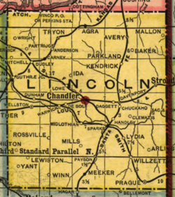
Geography
United States Census Bureau
The United States Census Bureau is the government agency that is responsible for the United States Census. It also gathers other national demographic and economic data...
, the county has a total area of 966 square miles (2,501.9 km²), of which 958 square miles (2,481.2 km²) is land and 8 square miles (20.7 km²) (0.82%) is water.
Major highways
 Interstate 44
 U.S. Highway 62
 U.S. Highway 177
 U.S. Highway 377
 State Highway 18State Highway 18 (Oklahoma)State Highway 18, abbreviated as SH-18 or OK-18, is a highway maintained by the U.S. state of Oklahoma. It was once one of the longest state highways in the Oklahoma road system, but now has a total length of .-Route description:...
 State Highway 66State Highway 66 (Oklahoma)State Highway 66 is a 196-mile state highway in the U.S. state of Oklahoma, beginning at U.S. Highway 81 in El Reno and ending at U.S. Highway 60 near White Oak. The highway was designated in 1985 as a replacement for the decommissioned US-66...
 State Highway 99State Highway 99 (Oklahoma)State Highway 99, also referred to as SH-99 or OK-99, is a north–south state highway through central Oklahoma. It runs from the Texas border at Lake Texoma to the Kansas border near Lake Hulah. It is long. The highway overlaps US-377 for over half its length.SH-99 links up with K-99 after...
Adjacent counties
- Payne CountyPayne County, OklahomaPayne County is a county in the U.S. state of Oklahoma. The population as of 2010 was 77,350. Its county seat is Stillwater, and the county is named for Capt. David L. Payne...
(north) - Creek CountyCreek County, OklahomaCreek County is a county located in the U.S. state of Oklahoma. As of 2010, the population was 69,967. Its county seat is Sapulpa.-Geography:According to the U.S. Census Bureau, the county has a total area of , of which is land and is water....
(northeast) - Okfuskee CountyOkfuskee County, OklahomaOkfuskee County is a county located in the U.S. state of Oklahoma. As of 2000, the population was 11,814. Its county seat is Okemah.-Geography:...
(southeast) - Pottawatomie CountyPottawatomie County, OklahomaPottawatomie County is a county located in the U.S. state of Oklahoma. The population was 65,521 as of the 2000 census. Its county seat is Shawnee...
(south) - Oklahoma CountyOklahoma County, OklahomaOklahoma County is a county located in the central partof the U.S. state of Oklahoma. The population was 718,633 at the 2010 census. The county seat and principal city is Oklahoma City...
(southwest) - Logan CountyLogan County, OklahomaLogan County is a county located in the U.S. state of Oklahoma. The population as of 2009 was 39,301. Its county seat is Guthrie. Logan County is part of the Oklahoma City Metropolitan Statistical Area.-Geography:...
(northwest)
Demographics
As of the censusCensus
A census is the procedure of systematically acquiring and recording information about the members of a given population. It is a regularly occurring and official count of a particular population. The term is used mostly in connection with national population and housing censuses; other common...
of 2000, there were 32,080 people, 12,178 households, and 9,121 families residing in the county. The population density
Population density
Population density is a measurement of population per unit area or unit volume. It is frequently applied to living organisms, and particularly to humans...
was 34 people per square mile (13/km²). There were 13,712 housing units at an average density of 14 per square mile (6/km²). The racial makeup of the county was 86.43% White
Race (United States Census)
Race and ethnicity in the United States Census, as defined by the Federal Office of Management and Budget and the United States Census Bureau, are self-identification data items in which residents choose the race or races with which they most closely identify, and indicate whether or not they are...
, 2.46% Black
Race (United States Census)
Race and ethnicity in the United States Census, as defined by the Federal Office of Management and Budget and the United States Census Bureau, are self-identification data items in which residents choose the race or races with which they most closely identify, and indicate whether or not they are...
or African American
Race (United States Census)
Race and ethnicity in the United States Census, as defined by the Federal Office of Management and Budget and the United States Census Bureau, are self-identification data items in which residents choose the race or races with which they most closely identify, and indicate whether or not they are...
, 6.57% Native American
Race (United States Census)
Race and ethnicity in the United States Census, as defined by the Federal Office of Management and Budget and the United States Census Bureau, are self-identification data items in which residents choose the race or races with which they most closely identify, and indicate whether or not they are...
, 0.25% Asian
Race (United States Census)
Race and ethnicity in the United States Census, as defined by the Federal Office of Management and Budget and the United States Census Bureau, are self-identification data items in which residents choose the race or races with which they most closely identify, and indicate whether or not they are...
, 0.02% Pacific Islander
Race (United States Census)
Race and ethnicity in the United States Census, as defined by the Federal Office of Management and Budget and the United States Census Bureau, are self-identification data items in which residents choose the race or races with which they most closely identify, and indicate whether or not they are...
, 0.45% from other races
Race (United States Census)
Race and ethnicity in the United States Census, as defined by the Federal Office of Management and Budget and the United States Census Bureau, are self-identification data items in which residents choose the race or races with which they most closely identify, and indicate whether or not they are...
, and 3.82% from two or more races. 1.51% of the population were Hispanic
Race (United States Census)
Race and ethnicity in the United States Census, as defined by the Federal Office of Management and Budget and the United States Census Bureau, are self-identification data items in which residents choose the race or races with which they most closely identify, and indicate whether or not they are...
or Latino
Race (United States Census)
Race and ethnicity in the United States Census, as defined by the Federal Office of Management and Budget and the United States Census Bureau, are self-identification data items in which residents choose the race or races with which they most closely identify, and indicate whether or not they are...
of any race.
There were 12,178 households out of which 34.10% had children under the age of 18 living with them, 61.50% were married couples
Marriage
Marriage is a social union or legal contract between people that creates kinship. It is an institution in which interpersonal relationships, usually intimate and sexual, are acknowledged in a variety of ways, depending on the culture or subculture in which it is found...
living together, 9.20% had a female householder with no husband present, and 25.10% were non-families. 22.40% of all households were made up of individuals and 10.50% had someone living alone who was 65 years of age or older. The average household size was 2.59 and the average family size was 3.03.
In the county, the population was spread out with 27.40% under the age of 18, 7.80% from 18 to 24, 26.70% from 25 to 44, 24.10% from 45 to 64, and 13.90% who were 65 years of age or older. The median age was 38 years. For every 100 females there were 97.30 males. For every 100 females age 18 and over, there were 94.50 males.
The median income for a household in the county was $31,187, and the median income for a family was $36,310. Males had a median income of $28,647 versus $20,099 for females. The per capita income
Per capita income
Per capita income or income per person is a measure of mean income within an economic aggregate, such as a country or city. It is calculated by taking a measure of all sources of income in the aggregate and dividing it by the total population...
for the county was $14,890. About 11.10% of families and 14.50% of the population were below the poverty line, including 17.90% of those under age 18 and 12.10% of those age 65 or over.
Cities and towns
United States Congress
| Senators | Name | Party | First Elected | Level | |
|---|---|---|---|---|---|
| Senate Class 1 | Jim Inhofe Jim Inhofe James Mountain "Jim" Inhofe is the senior Senator from Oklahoma and a member of the Republican Party. First elected to the Senate in 1994, he is the ranking member of the United States Senate Committee on Environment and Public Works and was its chairman from 2003 to 2007. Inhofe served eight... |
Republican Republican Party (United States) The Republican Party is one of the two major contemporary political parties in the United States, along with the Democratic Party. Founded by anti-slavery expansion activists in 1854, it is often called the GOP . The party's platform generally reflects American conservatism in the U.S... |
1994 | Senior Senator | |
| Senate Class 2 | Tom Coburn Tom Coburn Thomas Allen "Tom" Coburn, M.D. , is an American politician, medical doctor, and Southern Baptist deacon. A member of the Republican Party, he currently serves as the junior U.S. Senator from Oklahoma. In the Senate, he is known as "Dr. No" for his tendency to place holds on and vote against bills... |
Republican Republican Party (United States) The Republican Party is one of the two major contemporary political parties in the United States, along with the Democratic Party. Founded by anti-slavery expansion activists in 1854, it is often called the GOP . The party's platform generally reflects American conservatism in the U.S... |
2004 | Junior Senator | |
| Representatives | Name | Party | First Elected | ||
| District 3 | Frank Lucas | Republican Republican Party (United States) The Republican Party is one of the two major contemporary political parties in the United States, along with the Democratic Party. Founded by anti-slavery expansion activists in 1854, it is often called the GOP . The party's platform generally reflects American conservatism in the U.S... |
1994 | ||
Oklahoma Senate
| District | Name | Party | First Elected | Hometown | |
|---|---|---|---|---|---|
| 28 | Harry Coates | Republican Republican Party (United States) The Republican Party is one of the two major contemporary political parties in the United States, along with the Democratic Party. Founded by anti-slavery expansion activists in 1854, it is often called the GOP . The party's platform generally reflects American conservatism in the U.S... |
2002 | Seminole Seminole, Oklahoma Seminole is a city in Seminole County, Oklahoma, United States. The population was 6,899 at the 2000 census. Seminole experienced a large population growth in the 1920s due to an oil boom... |
|
Oklahoma House of Representatives
| District | Name | Party | First Elected | Hometown | |
|---|---|---|---|---|---|
| 32 | Danny Morgan Danny Morgan (Oklahoma politician) Danny Morgan is a Democratic politician from Oklahoma. Morgan currently serves in the Oklahoma House of Representatives as the Minority Leader.Danny Morgan was first elected to the House of Representatives in 2002... |
Democrat Democratic Party (United States) The Democratic Party is one of two major contemporary political parties in the United States, along with the Republican Party. The party's socially liberal and progressive platform is largely considered center-left in the U.S. political spectrum. The party has the lengthiest record of continuous... |
2002 | Prague Prague, Oklahoma Prague is a city in Lincoln County, Oklahoma, United States. The population was 2,138 at the 2000 census.-Geography:Prague is located at .According to the United States Census Bureau, the city has a total area of , all of it land.... |
|
NRHP sites
The following sites in Lincoln County are listed on the National Register of Historic PlacesNational Register of Historic Places
The National Register of Historic Places is the United States government's official list of districts, sites, buildings, structures, and objects deemed worthy of preservation...
:
|
ZCBJ Lodge No. 46 The ZCBJ Lodge No. 46, also known as Bohemian Hall, is an historic building located in Prague, Oklahoma that was built in 1917. It was listed on the National Register of Historic Places on March 8, 1984. The building historically served as a meeting hall for the Czech community, hosting a ZCBJ... |