
Hydrography of the San Francisco Bay Area
Encyclopedia
San Francisco Bay
San Francisco Bay is a shallow, productive estuary through which water draining from approximately forty percent of California, flowing in the Sacramento and San Joaquin rivers from the Sierra Nevada mountains, enters the Pacific Ocean...
and Pacific Ocean
Pacific Ocean
The Pacific Ocean is the largest of the Earth's oceanic divisions. It extends from the Arctic in the north to the Southern Ocean in the south, bounded by Asia and Australia in the west, and the Americas in the east.At 165.2 million square kilometres in area, this largest division of the World...
.
Bays
The largest bodies of water in the Bay Area are the San Francisco BaySan Francisco Bay
San Francisco Bay is a shallow, productive estuary through which water draining from approximately forty percent of California, flowing in the Sacramento and San Joaquin rivers from the Sierra Nevada mountains, enters the Pacific Ocean...
, San Pablo Bay
San Pablo Bay
San Pablo Bay is a tidal estuary that forms the northern extension of San Francisco Bay in northern California in the United States. Most of the Bay is shallow; however, there is a deep water channel approximately in mid bay, which allows access to Sacramento, Stockton, Benicia, Martinez, and...
, and Suisun Bay
Suisun Bay
Suisun Bay is a shallow tidal estuary at in northern California, USA. It lies at the confluence of the Sacramento and San Joaquin Rivers, forming the entrance to the Sacramento-San Joaquin River Delta, an inverted river delta...
. The San Francisco Bay is one of the largest bays in the world. Many inlets on the edges of the three major bays are designated as bays in their own right, such as Richardson Bay
Richardson Bay
Richardson Bay is a shallow, ecologically rich arm of San Francisco Bay, managed under a Joint Powers Agency of four Northern California cities. The Richardson Bay Sanctuary was acquired in the early 1960s by the National Audubon Society. The bay was named for William A...
, San Rafael Bay
San Rafael Bay
San Rafael Bay is an embayment of San Pablo Bay, the northern portion of the larger San Francisco Bay, on the west coast of the United States....
, Grizzly Bay
Grizzly Bay
Grizzly Bay is a baylet of the San Francisco Bay which dips into Solano County, California and borders Suisun Bay. Grizzly Bay is home to many sloughs and wildlife areas in addition to the 5th Reserve Fleet which is docked off the coast of Benicia....
, and San Leandro Bay
San Leandro Bay
San Leandro Bay is a body of water in the San Francisco Bay. It is connected to the Oakland Estuary today, but was originally separated by land which formerly connected Alameda with Oakland. It is located along the east of the Oakland International Airport and Bay Farm Island. The principal...
.
Nearby bays along the Pacific Coast include Bodega Bay
Bodega Bay
Bodega Bay is a shallow, rocky inlet of the Pacific Ocean on the coast of northern California in the United States. It is approximately across and is located approximately northwest of San Francisco and west of Santa Rosa...
, Tomales Bay
Tomales Bay
Tomales Bay is a long narrow inlet of the Pacific Ocean in Marin County in northern California in the United States. It is approximately 15 miles long and averages nearly 1.0 miles wide, effectively separating the Point Reyes Peninsula from the mainland of Marin County. It is located...
, Drakes Bay
Drakes Bay
Drakes Bay is a small bay on the coast of northern California in the United States, approximately 30 miles northwest of San Francisco at approximately 38 degrees north latitude. The bay is approximately 8 miles wide...
, Bolinas Bay
Bolinas Bay
Bolinas Bay is a small bay, approximately 5 miles wide, on the Pacific coast of California in the United States. It is in Marin County, north of the Golden Gate, approximately 15 miles northwest of San Francisco...
, and Half Moon Bay
Half Moon Bay
Half Moon Bay is a city in San Mateo County, CaliforniaHalf Moon Bay may also refer to:- Geographic features :* Half Moon Bay , a bay on the San Mateo County Coast of California...
.
Rivers
The largest rivers are the SacramentoSacramento River
The Sacramento River is an important watercourse of Northern and Central California in the United States. The largest river in California, it rises on the eastern slopes of the Klamath Mountains, and after a journey south of over , empties into Suisun Bay, an arm of the San Francisco Bay, and...
and San Joaquin
San Joaquin River
The San Joaquin River is the largest river of Central California in the United States. At over long, the river starts in the high Sierra Nevada, and flows through a rich agricultural region known as the San Joaquin Valley before reaching Suisun Bay, San Francisco Bay, and the Pacific Ocean...
Rivers which drain into the Sacramento-San Joaquin River Delta and thence to Suisun Bay
Suisun Bay
Suisun Bay is a shallow tidal estuary at in northern California, USA. It lies at the confluence of the Sacramento and San Joaquin Rivers, forming the entrance to the Sacramento-San Joaquin River Delta, an inverted river delta...
. Other major rivers of the North Bay
North Bay (San Francisco Bay Area)
The North Bay is a subregion of the San Francisco Bay Area, in California, United States. The largest city is Santa Rosa. It is by far the least populous and least urbanized part of the Bay Area...
are the Napa River
Napa River
The Napa River, approximately 55 miles long, is a river in the U.S. state of California. It drains a famous wine-growing region, called the Napa Valley, in the mountains northeast of San Francisco. Milliken Creek is a tributary of the Napa River....
, the Petaluma River
Petaluma River
The Petaluma River is a river in the California counties of Sonoma and Marin that becomes a tidal slough near its mouth. It springs from farmlands southwest of Cotati and flows generally southward through Petaluma's old town and of tidal marshes to end in northwest San Pablo Bay.-History:The word...
, the Gualala River
Gualala River
The Gualala River is a river on the northern coast of California. Most of the river is in Sonoma County, but a portion is in Mendocino County. The headwaters of the river are high in the Coast Range, and it empties into the Pacific Ocean...
, and the Russian River
Russian River (California)
The Russian River, a southward-flowing river, drains of Sonoma and Mendocino counties in Northern California. With an annual average discharge of approximately , it is the second largest river flowing through the nine county Greater San Francisco Bay Area with a mainstem 110 miles ...
; the former two drain into San Pablo Bay
San Pablo Bay
San Pablo Bay is a tidal estuary that forms the northern extension of San Francisco Bay in northern California in the United States. Most of the Bay is shallow; however, there is a deep water channel approximately in mid bay, which allows access to Sacramento, Stockton, Benicia, Martinez, and...
, the latter two into the Pacific Ocean
Pacific Ocean
The Pacific Ocean is the largest of the Earth's oceanic divisions. It extends from the Arctic in the north to the Southern Ocean in the south, bounded by Asia and Australia in the west, and the Americas in the east.At 165.2 million square kilometres in area, this largest division of the World...
.
In the South Bay, the Guadalupe River
Guadalupe River (California)
The Guadalupe River is a short river in California whose headwater creeks originate in the Santa Cruz Mountains near the summit of Loma Prieta and Mount Umunhum. The river mainstem now begins on the Santa Clara Valley floor at the northern end of Lake Almaden, which is fed by Los Alamitos Creek and...
drains into San Francisco Bay
San Francisco Bay
San Francisco Bay is a shallow, productive estuary through which water draining from approximately forty percent of California, flowing in the Sacramento and San Joaquin rivers from the Sierra Nevada mountains, enters the Pacific Ocean...
near Alviso
Alviso, San Jose, California
Alviso is a small community in San Jose, Santa Clara County, California. It is located approximately south of Drawbridge, at the north end of San José where it meets the southern end of the San Francisco Bay and borders the nearby city of Milpitas....
.
Creeks
The Bay Area has a network of streamsSTREAMS
In computer networking, STREAMS is the native framework in Unix System V for implementing character devices.STREAMS was designed as a modular architecture for implementing full-duplex I/O between kernel or user space processes and device drivers. Its most frequent uses have been in developing...
that are generally called creeks, but sometimes called arroyos, due to the Spanish language
Spanish language
Spanish , also known as Castilian , is a Romance language in the Ibero-Romance group that evolved from several languages and dialects in central-northern Iberia around the 9th century and gradually spread with the expansion of the Kingdom of Castile into central and southern Iberia during the...
heritage evident in names such as Santa Rosa Creek
Santa Rosa Creek
Santa Rosa Creek is a 22 mile long stream in Sonoma County, California which rises on Hood Mountain and discharges to the Laguna de Santa Rosa by way of the Santa Rosa Flood Control Channel...
and San Pablo Creek
San Pablo Creek
San Pablo Creek is an creek in Contra Costa County, California, United States, which drains the canyon or valley between the San Pablo Ridge and the Sobrante Ridge, parts of the Pacific Coast Ranges east of San Francisco Bay....
. Due to low rainfall in the summer months (May–October), many Bay Area creeks are intermittent, flowing above ground only during part of the year.
Political groups have been formed to preserve creeks or restore creeks which have been culverted for development. Baxter Creek
Baxter Creek
Baxter Creek or Stege Creek , is a three-branch creek in Richmond and El Cerrito, California, United States forming the Baxter Creek watershed. The creek has three sources and flows from the Berkeley Hills to Stege Marsh and the San Francisco Bay...
in Contra Costa County
Contra Costa County, California
Contra Costa County is a primarily suburban county in the San Francisco Bay Area of the U.S. state of California. As of the 2010 census, it had a population of 1,049,025...
has been daylighted in various points along its piped route by Friends of Baxter Creek. Other organizations include Friends of Five Creeks which monitors, restores, cleans and educates in relation to creeks flowing from the Berkeley Hills
Berkeley Hills
The Berkeley Hills are a range of the Pacific Coast Ranges that overlook the northeast side of the valley that surrounds San Francisco Bay. They were previously called the "Contra Costa Range/Hills" , but with the establishment of Berkeley and the University of California, the current usage was...
to the Eastshore Estaury in the East Bay
East Bay (San Francisco Bay Area)
The East Bay is a commonly used, informal term for the lands on the eastern side of the San Francisco Bay, in the San Francisco Bay Area, in California, United States...
.
Guide to San Francisco Bay Area Creeks
Springs
The Bay Area has springs which are the source of most of the minor creeks in the East Bay hills such as Garrity CreekGarrity Creek
Garrity Creek is a creek in Richmond, California's Hilltop neighborhood. It runs into San Pablo Bay. It is sometimes called Hilltop Creek.The creek is supported by two natural springs from two short sources which join into Garrity Creek...
. In the North Bay there are hot springs which serve as further tourist attractions to Wine Country tourists and spa goers.
Lakes
The Bay Area has many lakes, particularly if one includes artificial ones such as Lake BerryessaLake Berryessa
Lake Berryessa is the largest lake in Napa County, California. This reservoir is formed by the Monticello Dam, which provides water and hydroelectricity to the North Bay region of the San Francisco Bay Area....
. Some are very small (such as Jewel Lake
Jewel Lake
Jewel Lake is a former reservoir and artificual lake along Wildcat Creek, a small stream in Northern California in Tilden Regional Park. It is located in the Wildcat Canyon between the Berkeley Hills and Sobrante Ridge Hills in an unincorporated area closest to Richmond and Kensington, California...
in Berkeley
Berkeley, California
Berkeley is a city on the east shore of the San Francisco Bay in Northern California, United States. Its neighbors to the south are the cities of Oakland and Emeryville. To the north is the city of Albany and the unincorporated community of Kensington...
) and others are covered (Summit Reservoir, for example). Lake Merced
Lake Merced
Lake Merced is a freshwater lake in the southwest corner of San Francisco. It is surrounded by three golf courses , as well as residential areas, Lowell High School, San Francisco State University, Fort Funston and the Pacific Ocean...
and Lake Merritt
Lake Merritt
Lake Merritt is a large tidal lagoon that lies just east of downtown Oakland, California. It is surrounded by parkland and city neighborhoods. A popular 3.1 mile walking and jogging path runs along its perimeter...
are salt lakes; the former is drying up while the latter is a closed off estuarine cove.
Aquifers
Due to pollution of surface water, much of the area's potable water is located underground, for instance in the Mocho SubbasinMocho Subbasin
The Mocho Subbasin is the largest of the groundwater subbasins in the Livermore Valley watershed. This subbasin is bounded to the west by the Livermore Fault Zone and to the east by the Tesla Fault...
of the Livermore Valley
Livermore Valley
The Livermore Valley AVA is an American Viticultural Area in Alameda County, California, surrounding the city of Livermore in the Tri-Valley region. Both the AVA and the city are named after Robert Livermore, a landowner whose holdings encompassed the valley. The groundwater basin underlying the...
. As these aquifers get drawn down by pumping, there is increasing interest in ways to speed up the recharging of these resources.
Wetlands
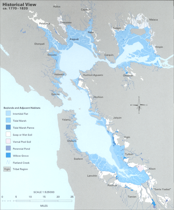
Prior to the introduction of European agricultural methods, the shores of San Francisco Bay consisted mostly of tidal marshes. Approximately 85% of those marshes have been lost or destroyed, but about 50 marshes and marsh fragments remain. In the Delta area, marshes were drained for farmland. In San Francisco, marshes were filled in for urban development. In the East Bay, portions were used as landfill. In the South Bay, huge tracts have served as commercial salt evaporation pondSalt evaporation pond
Salt evaporation ponds, also called salterns or salt pans, are shallow artificial ponds designed to produce salts from sea water or other brines. The seawater or brine is fed into large ponds and water is drawn out through natural evaporation which allows the salt to be subsequently harvested...
s. In the North Bay, the Napa Sonoma Marsh
Napa Sonoma Marsh
The Napa Sonoma Marsh is a wetland at the northern edge of San Pablo Bay, which is a northern arm of the San Francisco Bay in California, USA. This marsh has an area of 48,000 acres , of which 13,000 acres are abandoned salt evaporation ponds...
and Point Molate Marsh
Point Molate Marsh
Point Molate Marsh is a salt marsh on the western shoreline of the San Pablo Peninsula in Richmond, California.-Overview:The area is environmentally valuable land as it is largely untouched and isolated from nearby urban development. The marsh was once used as a Chinese shrimp camp. It is habitat...
remain productive ecosystems. Some wetlands have been restored or protected from further development. Success stories include Eastshore State Park
Eastshore State Park
Eastshore State Park is a state park and wildlife refuge along the San Francisco Bay shoreline of the East Bay between the cities of Richmond, Albany, Berkeley, Emeryville, and Oakland. It encompasses remnant natural wetlands, restored wetlands as well as landfill west of the Eastshore Freeway. It...
and Crissy Field
Crissy Field
Crissy Field is a former airfield, now a part of the Golden Gate National Parks Conservancy in San Francisco, California, United States. Historically a part of the Presidio of San Francisco, Crissy Field was closed as an airfield and eventually the National Park Service took control over it...
. Many native and recovered wetlands are preserved in the Don Edwards San Francisco Bay National Wildlife Refuge
Don Edwards San Francisco Bay National Wildlife Refuge
Don Edwards San Francisco Bay National Wildlife Refuge is a US National Wildlife Refuge located in the southern part of San Francisco Bay, California. The Refuge headquarters and visitor center is located in the Baylands district of Fremont, next to Coyote Hills Regional Park, in Alameda County. ...
and the San Pablo Bay National Wildlife Refuge
San Pablo Bay National Wildlife Refuge
San Pablo Bay National Wildlife Refuge is a National Wildlife Refuge in California established in 1970. It extends along the northern shore of San Pablo Bay from the mouth of the Petaluma River to Tolay Creek, Sonoma Creek and ends at Mare Island...
.
Wetlands also exist on the Pacific Coast (the Estero Americano, for instance) and in certain inland valleys: for example, the Laguna de Santa Rosa
Laguna de Santa Rosa
The Laguna de Santa Rosa is a long wetland complex that drains a 254-square mile watershed encompassing most of the Santa Rosa Plain in Sonoma County, California, USA.-Description:...
near Santa Rosa
Santa Rosa, California
Santa Rosa is the county seat of Sonoma County, California, United States. The 2010 census reported a population of 167,815. Santa Rosa is the largest city in California's Wine Country and fifth largest city in the San Francisco Bay Area, after San Jose, San Francisco, Oakland, and Fremont and 26th...
.
Transportation
The Bay Area is a large natural harbor. Around it have grown seaports and naval facilities. Active ports include the ports of RichmondRichmond, California
Richmond is a city in western Contra Costa County, California, United States. The city was incorporated on August 7, 1905. It is located in the East Bay, part of the San Francisco Bay Area. It is a residential inner suburb of San Francisco, as well as the site of heavy industry, which has been...
, Redwood City
Redwood City, California
Redwood City is a California charter city located on the San Francisco Peninsula in Northern California, approximately 27 miles south of San Francisco, and 24 miles north of San Jose. Redwood City's history spans from its earliest inhabitation by the Ohlone people, to its tradition as a port for...
, San Francisco
San Francisco, California
San Francisco , officially the City and County of San Francisco, is the financial, cultural, and transportation center of the San Francisco Bay Area, a region of 7.15 million people which includes San Jose and Oakland...
, and Oakland
Oakland, California
Oakland is a major West Coast port city on San Francisco Bay in the U.S. state of California. It is the eighth-largest city in the state with a 2010 population of 390,724...
. Ships also traverse the bay heading to and from ports in Stockton
Stockton, California
Stockton, California, the seat of San Joaquin County, is the fourth-largest city in the Central Valley of the U.S. state of California. With a population of 291,707 at the 2010 census, Stockton ranks as this state's 13th largest city...
and Sacramento
Sacramento, California
Sacramento is the capital city of the U.S. state of California and the county seat of Sacramento County. It is located at the confluence of the Sacramento River and the American River in the northern portion of California's expansive Central Valley. With a population of 466,488 at the 2010 census,...
. During World War I
World War I
World War I , which was predominantly called the World War or the Great War from its occurrence until 1939, and the First World War or World War I thereafter, was a major war centred in Europe that began on 28 July 1914 and lasted until 11 November 1918...
and World War II
World War II
World War II, or the Second World War , was a global conflict lasting from 1939 to 1945, involving most of the world's nations—including all of the great powers—eventually forming two opposing military alliances: the Allies and the Axis...
the region was the United States
United States
The United States of America is a federal constitutional republic comprising fifty states and a federal district...
's major shipbuiding center for the Pacific. Former naval facilities include Point Molate Naval Refueling Depot, Alameda Point Naval Facility and Mare Island Naval Shipyard
Mare Island Naval Shipyard
The Mare Island Naval Shipyard was the first United States Navy base established on the Pacific Ocean. It is located 25 miles northeast of San Francisco in Vallejo, California. The Napa River goes through the Mare Island Strait and separates the peninsula shipyard from the main portion of the...
.
Many Bay Area cites have marinas, including Berkeley
Berkeley Marina
The Berkeley Marina is the westernmost portion of the city of Berkeley, California, located west of the Eastshore Freeway at the foot of University Avenue on San Francisco Bay...
, Petaluma
Petaluma, California
Petaluma is a city in Sonoma County, California, in the United States. In the 2010 Census the population was 57,941.Located in Petaluma is the Rancho Petaluma Adobe, a National Historic Landmark. It was built beginning in 1836 by General Mariano Guadalupe Vallejo, then Commandant of the San...
, and Redwood City
Redwood City, California
Redwood City is a California charter city located on the San Francisco Peninsula in Northern California, approximately 27 miles south of San Francisco, and 24 miles north of San Jose. Redwood City's history spans from its earliest inhabitation by the Ohlone people, to its tradition as a port for...
.
There is also an extensive commuter ferry system, which is being expanded by the San Francisco Bay Water Transit Authority.
Oceanic harbors have been built at Bodega Bay
Bodega Harbor
Bodega Harbor is a small shallow natural harbor on the Pacific coast of northern California in the United States, approximately 40 mi northwest of San Francisco...
and Half Moon Bay
Pillar Point Harbor
Pillar Point Harbor is a boat harbor created by a riprap jetty in San Mateo County, California immediately north of Half Moon Bay. The site was originally inhabited by the Ohlone people in prehistoric times, and a number of recorded shipwrecks occurred in the immediate area. The harbor facilities...
.
See also
- Ecology of the San Francisco EstuaryEcology of the San Francisco EstuaryThe San Francisco Estuary and delta represents a highly altered ecosystem. The region has been heavily re-engineered to accommodate the needs of water delivery, shipping, agriculture, and most recently, suburban development...
- U.S. Army Corps of Engineers Bay ModelU.S. Army Corps of Engineers Bay ModelThe U.S. Army Corps of Engineers Bay Model is a working hydraulic scale model of the San Francisco Bay and Sacramento-San Joaquin River Delta System. While the Bay Model is still operational, it is no longer used for scientific research, and is instead open to the public alongside educational...