

Hurricane Kiko (1989)
Encyclopedia
Hurricane Kiko was one of the strongest tropical cyclone
s to ever make landfall on the eastern coast of the Baja California Peninsula
. The eleventh named storm of the 1989 Pacific hurricane season
, Kiko formed out of a large mesoscale convective system
on August 25. Slowly tracking northwestward, the storm rapidly intensified
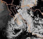
into a hurricane early the next day. Strengthening continued until early August 27, when Kiko reached its peak intensity with winds of 120 mph (195 km/h). The storm turned west at this time, and at around 0600 UTC, the storm made landfall
near Punta Arena on the southern tip of Baja California. The hurricane rapidly weakened into a tropical storm later that day and further into a tropical depression by August 28, shortly after entering the Pacific Ocean
. The depression persisted for another day while tracking southward, before being absorbed by nearby Tropical Storm Lorena. Though Kiko made landfall as a Category 3 hurricane, its impact was relatively minor. Press reports indicated that 20 homes were destroyed and numerous highways were flooded by torrential rains.
between 1988 and 1990 that began as tropical wave
s off the western coast of Africa, Hurricane Kiko developed out of a large-scale mesoscale convective system
on August 23 on the coast of Sonora
. The system slowly tracked southward into the Gulf of California
and became increasingly organized. Shower and thunderstorm
activity was present around an area of low pressure
the following day; however, insufficient reports from the region hindered the National Hurricane Center
's (NHC) forecasting ability. By August 25, satellite intensity estimates, using the Dvorak technique
, indicated that the low had developed into a tropical depression around 1200 UTC, while the storm was located about 115 miles (185 kilometers) south of Mazatlan, Mexico. Operationally, the system was not declared a tropical depression; instead it was immediately declared Tropical Storm Kiko with winds of 40 mph (65 km/h). Located within an area with little or no steering current, and situated over warm waters and underneath an upper-level low, conditions were near perfect for rapid intensification
, despite the proximity to land. A general northwestward drift was anticipated, and the NHC forecast the storm to reach hurricane intensity within 24 hours.
Convective banding features
began to develop late on August 25 as winds around the center reached 50 mph (85 km/h). With the development of an anticyclone
over the storm, Kiko's outflow
become more pronounced. Around 0600 UTC on August 26, an eye
developed within the small circulation, suggesting the cyclone had strengthened into a Category 1 hurricane on the Saffir-Simpson Hurricane Scale
. However, satellite intensity estimates indicated winds of only 40 mph (65 km/h). Shortly after, Kiko was upgraded to a Category 2 hurricane with winds of 100 mph (155 km/h). Ships in the vicinity of the hurricane determined that tropical storm-force winds extended roughly 50 mi (85 km) from the center. Winds within the eyewall subsequently increased to 115 mph (185 km/h), making Kiko a minimal Category 3 hurricane. Intensification continued for another six hours, ending around 0000 UTC on August 27, at which time the storm reached its peak intensity with winds of 120 mph (195 km/h) and a minimum pressure of 955 mbar
(hPa
; 28.2 inHg).
Around the time of peak intensity, Dvorak intensity estimates reached T6.0, equating to a minimal Category 4 hurricane with winds of 135 mph (215 km/h). A trough
located to the north of the hurricane began to weaken, causing the storm to track in a more westward direction. Kiko weakened slightly before making landfall
near Punta Arena, on the southern tip of Baja California, with winds of 115 mph (185 mph). Kiko was thus the second major hurricane to ever make landfall on the Gulf Coast of Baja California since reliable recordkeeping began in 1949, with the other being 1967's Hurricane Olivia. Due to the small size and slow movement of the storm, it rapidly weakened, becoming a tropical storm by 1800 UTC. Convection associated with the storm significantly diminished; the center of circulation became nearly devoid of thunderstorm activity early on August 28. Shortly after emerging into the Pacific Ocean
, Kiko was further downgraded into a tropical depression, and turned towards the southwest due to interaction with nearby Tropical Storm Lorena. Tropical Depression Kiko dissipated around 1800 UTC on August 29; however, its remnants continued southward before being absorbed by Lorena.
for the Islas Marías
and areas between the southern border of Sonora
and El Dorado
. A hurricane watch was also issued for areas between Los Burros and the southern tip of Baja California Sur
along the Gulf of California
. By 0900 UTC the following day, the hurricane watch was upgraded to a warning. Roughly three hours later, the previous hurricane watch issued for Sonora was discontinued as Kiko was no longer forecast to make landfall in the state. The hurricane warning on Baja California was also extended northward to Bahía Concepción
. Due to uncertainty in Kiko's track, a hurricane watch was re-issued for Sonora between El Dorado and Los Mochis. Around 0900 UTC on August 27, a hurricane warning was issued for areas south of San Carlos on the Pacific coast
of Baja California. The hurricane watch for Sonora was then discontinued. By 1800 UTC, the hurricane warnings on the Gulf Coast of Baja California were replaced by a tropical storm warning which was declared for areas between the southern tip of the peninsula and Bahía Concepción. At this time, the hurricane warning for the Pacific coast was revised to a tropical storm warning. Early on August 28, all watches and warnings were discontinued as Kiko weakened into a tropical depression and moved away from land.
In Baja California Sur, more than 1,300 people evacuated to shelters in La Paz
. Flights arriving and departing in the region were canceled or diverted to other airports. The Red Cross prepared shelters in schools, hospitals, and other public buildings throughout the city. On the Islas Marías, an unconfirmed report of 54 mph (86.9 km/h) sustained winds was relayed to the National Hurricane Center
. Due to the hurricane's small size, only areas directly in the path of the storm received precipitation; however, a monsoon
al outer band on the eastern side of the storm produced widespread rainfall in eastern Mexico. In Sonora, over 7 in (177.8 mm) of rain fell in mountainous areas, while numerous locations recorded at least 1 in (25.4 mm). In Baja California, the heaviest rainfall was recorded in Los Cabos
, and amounted to 11.97 in (304 mm). Only a small portion of the peninsula received more than 10 in (254 mm) of rain. At least 1,000 people were evacuated from heavily damaged areas. Press reports indicated that 20 homes were destroyed by Hurricane Kiko. High winds, gusting over 109 mph (175.4 km/h), brought down numerous trees and power lines.
 Before Kiko's eye moved ashore, the airport near Cabo San Lucas
reported sustained winds of 47 mph (75.6 km/h) with gusts up to 63 mph (101.4 km/h). Meteorological recordings near the place of landfall were not available as the small system tracked over a sparsely populated region. From La Paz to Cabo San Lucas, power and water supplies were lost. The heavy rains flooded several highways, and the resultant flood waters overturned a bus. Passengers on the bus managed to escape injury and were quickly brought to shelter by the local fire department. The storm's effects washed out roughly 100 yd (91.4 m) of the San Antonio-San Bartolome highway. The Rancho Leonero Resort in Buena Vista sustained severe roof damage and several docked boats were damaged. Several days after Kiko dissipated, remnant moisture from the storm contributed to a complex weather system that produced torrential rainfall throughout Kansas
, unofficially reaching 16 in (406.4 mm) in localized areas; as a result, two people in Wichita
died after two vehicles collided on a rain-slicked highway.
Tropical cyclone
A tropical cyclone is a storm system characterized by a large low-pressure center and numerous thunderstorms that produce strong winds and heavy rain. Tropical cyclones strengthen when water evaporated from the ocean is released as the saturated air rises, resulting in condensation of water vapor...
s to ever make landfall on the eastern coast of the Baja California Peninsula
Baja California Peninsula
The Baja California peninsula , is a peninsula in northwestern Mexico. Its land mass separates the Pacific Ocean from the Gulf of California. The Peninsula extends from Mexicali, Baja California in the north to Cabo San Lucas, Baja California Sur in the south.The total area of the Baja California...
. The eleventh named storm of the 1989 Pacific hurricane season
1989 Pacific hurricane season
-Tropical Storm Adolph:The first storm of the season developed out of a weak area of low pressure situated about 570 mi south-southwest of Acapulco, Mexico. Tracking towards the west, the circluation briefly dissipated on May 30, before redeveloping the following day into Tropical...
, Kiko formed out of a large mesoscale convective system
Mesoscale Convective System
A mesoscale convective system is a complex of thunderstorms that becomes organized on a scale larger than the individual thunderstorms but smaller than extratropical cyclones, and normally persists for several hours or more...
on August 25. Slowly tracking northwestward, the storm rapidly intensified
Rapid deepening
Rapid deepening, also known as rapid intensification, is a meteorological condition that occurs when the minimum sea-level atmospheric pressure of a tropical cyclone decreases drastically in a short period of time. The National Weather Service describes rapid deepening as a decrease of...
into a hurricane early the next day. Strengthening continued until early August 27, when Kiko reached its peak intensity with winds of 120 mph (195 km/h). The storm turned west at this time, and at around 0600 UTC, the storm made landfall
Landfall (meteorology)
Landfall is the event of a tropical cyclone or a waterspout coming onto land after being over water. When a waterspout makes landfall it is reclassified as a tornado, which can then cause damage inland...
near Punta Arena on the southern tip of Baja California. The hurricane rapidly weakened into a tropical storm later that day and further into a tropical depression by August 28, shortly after entering the Pacific Ocean
Pacific Ocean
The Pacific Ocean is the largest of the Earth's oceanic divisions. It extends from the Arctic in the north to the Southern Ocean in the south, bounded by Asia and Australia in the west, and the Americas in the east.At 165.2 million square kilometres in area, this largest division of the World...
. The depression persisted for another day while tracking southward, before being absorbed by nearby Tropical Storm Lorena. Though Kiko made landfall as a Category 3 hurricane, its impact was relatively minor. Press reports indicated that 20 homes were destroyed and numerous highways were flooded by torrential rains.
Meteorological history
Unlike most other eastern Pacific hurricanesPacific hurricane
A Pacific hurricane or tropical storm is a tropical cyclone that develops in the northeastern part of the Pacific Ocean. For organizational purposes, the northern Pacific Ocean is divided into three regions: the eastern, , central , and western...
between 1988 and 1990 that began as tropical wave
Tropical wave
Tropical waves, easterly waves, or tropical easterly waves, also known as African easterly waves in the Atlantic region, are a type of atmospheric trough, an elongated area of relatively low air pressure, oriented north to south, which move from east to west across the tropics causing areas of...
s off the western coast of Africa, Hurricane Kiko developed out of a large-scale mesoscale convective system
Mesoscale Convective System
A mesoscale convective system is a complex of thunderstorms that becomes organized on a scale larger than the individual thunderstorms but smaller than extratropical cyclones, and normally persists for several hours or more...
on August 23 on the coast of Sonora
Sonora
Sonora officially Estado Libre y Soberano de Sonora is one of the 31 states which, with the Federal District, comprise the 32 Federal Entities of Mexico. It is divided into 72 municipalities; the capital city is Hermosillo....
. The system slowly tracked southward into the Gulf of California
Gulf of California
The Gulf of California is a body of water that separates the Baja California Peninsula from the Mexican mainland...
and became increasingly organized. Shower and thunderstorm
Thunderstorm
A thunderstorm, also known as an electrical storm, a lightning storm, thundershower or simply a storm is a form of weather characterized by the presence of lightning and its acoustic effect on the Earth's atmosphere known as thunder. The meteorologically assigned cloud type associated with the...
activity was present around an area of low pressure
Low pressure area
A low-pressure area, or "low", is a region where the atmospheric pressure at sea level is below that of surrounding locations. Low-pressure systems form under areas of wind divergence which occur in upper levels of the troposphere. The formation process of a low-pressure area is known as...
the following day; however, insufficient reports from the region hindered the National Hurricane Center
National Hurricane Center
The National Hurricane Center , located at Florida International University in Miami, Florida, is the division of the National Weather Service responsible for tracking and predicting weather systems within the tropics between the Prime Meridian and the 140th meridian west poleward to the 30th...
's (NHC) forecasting ability. By August 25, satellite intensity estimates, using the Dvorak technique
Dvorak technique
The Dvorak technique is a widely used system to subjectively estimate tropical cyclone intensity based solely on visible and infrared satellite images. Several agencies issue Dvorak intensity numbers for cyclones of sufficient intensity...
, indicated that the low had developed into a tropical depression around 1200 UTC, while the storm was located about 115 miles (185 kilometers) south of Mazatlan, Mexico. Operationally, the system was not declared a tropical depression; instead it was immediately declared Tropical Storm Kiko with winds of 40 mph (65 km/h). Located within an area with little or no steering current, and situated over warm waters and underneath an upper-level low, conditions were near perfect for rapid intensification
Rapid deepening
Rapid deepening, also known as rapid intensification, is a meteorological condition that occurs when the minimum sea-level atmospheric pressure of a tropical cyclone decreases drastically in a short period of time. The National Weather Service describes rapid deepening as a decrease of...
, despite the proximity to land. A general northwestward drift was anticipated, and the NHC forecast the storm to reach hurricane intensity within 24 hours.
Convective banding features
Rainband
A rainband is a cloud and precipitation structure associated with an area of rainfall which is significantly elongated. Rainbands can be stratiform or convective, and are generated by differences in temperature. When noted on weather radar imagery, this precipitation elongation is referred to as...
began to develop late on August 25 as winds around the center reached 50 mph (85 km/h). With the development of an anticyclone
Anticyclone
An anticyclone is a weather phenomenon defined by the United States' National Weather Service's glossary as "[a] large-scale circulation of winds around a central region of high atmospheric pressure, clockwise in the Northern Hemisphere, counterclockwise in the Southern Hemisphere"...
over the storm, Kiko's outflow
Outflow (meteorology)
Outflow, in meteorology, is air that flows outwards from a storm system. It is associated with ridging, or anticyclonic flow. In the low levels of the troposphere, outflow radiates from thunderstorms in the form of a wedge of rain-cooled air, which is visible as a thin rope-like cloud on weather...
become more pronounced. Around 0600 UTC on August 26, an eye
Eye (cyclone)
The eye is a region of mostly calm weather found at the center of strong tropical cyclones. The eye of a storm is a roughly circular area and typically 30–65 km in diameter. It is surrounded by the eyewall, a ring of towering thunderstorms where the second most severe weather of a cyclone...
developed within the small circulation, suggesting the cyclone had strengthened into a Category 1 hurricane on the Saffir-Simpson Hurricane Scale
Saffir-Simpson Hurricane Scale
The Saffir–Simpson Hurricane Scale , or the Saffir–Simpson Hurricane Wind Scale , classifies hurricanes — Western Hemisphere tropical cyclones that exceed the intensities of tropical depressions and tropical storms — into five categories distinguished by the intensities of their sustained winds...
. However, satellite intensity estimates indicated winds of only 40 mph (65 km/h). Shortly after, Kiko was upgraded to a Category 2 hurricane with winds of 100 mph (155 km/h). Ships in the vicinity of the hurricane determined that tropical storm-force winds extended roughly 50 mi (85 km) from the center. Winds within the eyewall subsequently increased to 115 mph (185 km/h), making Kiko a minimal Category 3 hurricane. Intensification continued for another six hours, ending around 0000 UTC on August 27, at which time the storm reached its peak intensity with winds of 120 mph (195 km/h) and a minimum pressure of 955 mbar
Bar (unit)
The bar is a unit of pressure equal to 100 kilopascals, and roughly equal to the atmospheric pressure on Earth at sea level. Other units derived from the bar are the megabar , kilobar , decibar , centibar , and millibar...
(hPa
Pascal (unit)
The pascal is the SI derived unit of pressure, internal pressure, stress, Young's modulus and tensile strength, named after the French mathematician, physicist, inventor, writer, and philosopher Blaise Pascal. It is a measure of force per unit area, defined as one newton per square metre...
; 28.2 inHg).
Around the time of peak intensity, Dvorak intensity estimates reached T6.0, equating to a minimal Category 4 hurricane with winds of 135 mph (215 km/h). A trough
Trough (meteorology)
A trough is an elongated region of relatively low atmospheric pressure, often associated with fronts.Unlike fronts, there is not a universal symbol for a trough on a weather chart. The weather charts in some countries or regions mark troughs by a line. In the United States, a trough may be marked...
located to the north of the hurricane began to weaken, causing the storm to track in a more westward direction. Kiko weakened slightly before making landfall
Landfall (meteorology)
Landfall is the event of a tropical cyclone or a waterspout coming onto land after being over water. When a waterspout makes landfall it is reclassified as a tornado, which can then cause damage inland...
near Punta Arena, on the southern tip of Baja California, with winds of 115 mph (185 mph). Kiko was thus the second major hurricane to ever make landfall on the Gulf Coast of Baja California since reliable recordkeeping began in 1949, with the other being 1967's Hurricane Olivia. Due to the small size and slow movement of the storm, it rapidly weakened, becoming a tropical storm by 1800 UTC. Convection associated with the storm significantly diminished; the center of circulation became nearly devoid of thunderstorm activity early on August 28. Shortly after emerging into the Pacific Ocean
Pacific Ocean
The Pacific Ocean is the largest of the Earth's oceanic divisions. It extends from the Arctic in the north to the Southern Ocean in the south, bounded by Asia and Australia in the west, and the Americas in the east.At 165.2 million square kilometres in area, this largest division of the World...
, Kiko was further downgraded into a tropical depression, and turned towards the southwest due to interaction with nearby Tropical Storm Lorena. Tropical Depression Kiko dissipated around 1800 UTC on August 29; however, its remnants continued southward before being absorbed by Lorena.
Preparations and impact
Around 2100 UTC on August 25, the Government of Mexico issued a hurricane warningTropical cyclone warnings and watches
Warnings and watches are two levels of alert issued by national weather forecasting bodies to coastal areas threatened by the imminent approach of a tropical cyclone of tropical storm or hurricane intensity. They are notices to the local population and civil authorities to make appropriate...
for the Islas Marías
Islas Marías
The Islas Marías are an archipelago of four islands that belong to Mexico. They are located in the Pacific Ocean, some off the coast of the state of Nayarit. They are part of the municipality of San Blas, Nayarit...
and areas between the southern border of Sonora
Sonora
Sonora officially Estado Libre y Soberano de Sonora is one of the 31 states which, with the Federal District, comprise the 32 Federal Entities of Mexico. It is divided into 72 municipalities; the capital city is Hermosillo....
and El Dorado
El Dorado, Sinaloa
El Dorado is a community approximately one hour away from Culiacán in the Mexican state of Sinaloa. It is about a 20-minute drive from "Las Arenitas", a small fishing town.el dorado es caracterisado por sus umildes havitantes que en conjunto fe travajo hasen que el alimento y demas cosas...
. A hurricane watch was also issued for areas between Los Burros and the southern tip of Baja California Sur
Baja California Sur
Baja California Sur , is one of the 31 states which, with the Federal District, comprise the 32 Federal Entities of Mexico. Before becoming a state on October 8, 1974, the area was known as the South Territory of Baja California. It has an area of , or 3.57% of the land mass of Mexico and comprises...
along the Gulf of California
Gulf of California
The Gulf of California is a body of water that separates the Baja California Peninsula from the Mexican mainland...
. By 0900 UTC the following day, the hurricane watch was upgraded to a warning. Roughly three hours later, the previous hurricane watch issued for Sonora was discontinued as Kiko was no longer forecast to make landfall in the state. The hurricane warning on Baja California was also extended northward to Bahía Concepción
Bahía Concepción, Baja California Sur
Bahía Concepción is one of the largest bays of Baja California. Lying on the Sea of Cortez, and less than 20 miles south of Mulegé, Bahía Concepción features over 50 miles of beaches...
. Due to uncertainty in Kiko's track, a hurricane watch was re-issued for Sonora between El Dorado and Los Mochis. Around 0900 UTC on August 27, a hurricane warning was issued for areas south of San Carlos on the Pacific coast
Pacific Ocean
The Pacific Ocean is the largest of the Earth's oceanic divisions. It extends from the Arctic in the north to the Southern Ocean in the south, bounded by Asia and Australia in the west, and the Americas in the east.At 165.2 million square kilometres in area, this largest division of the World...
of Baja California. The hurricane watch for Sonora was then discontinued. By 1800 UTC, the hurricane warnings on the Gulf Coast of Baja California were replaced by a tropical storm warning which was declared for areas between the southern tip of the peninsula and Bahía Concepción. At this time, the hurricane warning for the Pacific coast was revised to a tropical storm warning. Early on August 28, all watches and warnings were discontinued as Kiko weakened into a tropical depression and moved away from land.
In Baja California Sur, more than 1,300 people evacuated to shelters in La Paz
La Paz, Baja California Sur
La Paz is the capital city of the Mexican state of Baja California Sur and an important regional commercial center. The city had a 2010 census population of 215,178 persons, but its metropolitan population is somewhat larger because of surrounding towns like el Centenario, el Zacatal and San Pedro...
. Flights arriving and departing in the region were canceled or diverted to other airports. The Red Cross prepared shelters in schools, hospitals, and other public buildings throughout the city. On the Islas Marías, an unconfirmed report of 54 mph (86.9 km/h) sustained winds was relayed to the National Hurricane Center
National Hurricane Center
The National Hurricane Center , located at Florida International University in Miami, Florida, is the division of the National Weather Service responsible for tracking and predicting weather systems within the tropics between the Prime Meridian and the 140th meridian west poleward to the 30th...
. Due to the hurricane's small size, only areas directly in the path of the storm received precipitation; however, a monsoon
Monsoon
Monsoon is traditionally defined as a seasonal reversing wind accompanied by corresponding changes in precipitation, but is now used to describe seasonal changes in atmospheric circulation and precipitation associated with the asymmetric heating of land and sea...
al outer band on the eastern side of the storm produced widespread rainfall in eastern Mexico. In Sonora, over 7 in (177.8 mm) of rain fell in mountainous areas, while numerous locations recorded at least 1 in (25.4 mm). In Baja California, the heaviest rainfall was recorded in Los Cabos
Los Cabos
Los Cabos is a municipality located at the southern tip of Mexico's Baja California Peninsula, in the state of Baja California Sur. It encompasses the towns of Cabo San Lucas and San José del Cabo , as well as the Resort Corridor that lies between the two...
, and amounted to 11.97 in (304 mm). Only a small portion of the peninsula received more than 10 in (254 mm) of rain. At least 1,000 people were evacuated from heavily damaged areas. Press reports indicated that 20 homes were destroyed by Hurricane Kiko. High winds, gusting over 109 mph (175.4 km/h), brought down numerous trees and power lines.
Cabo San Lucas
Cabo San Lucas , commonly called Cabo, is a city at the southern tip of the Baja California peninsula, in the municipality of Los Cabos in the Mexican state of Baja California Sur. As of the 2010 census, the population was 68,463 people...
reported sustained winds of 47 mph (75.6 km/h) with gusts up to 63 mph (101.4 km/h). Meteorological recordings near the place of landfall were not available as the small system tracked over a sparsely populated region. From La Paz to Cabo San Lucas, power and water supplies were lost. The heavy rains flooded several highways, and the resultant flood waters overturned a bus. Passengers on the bus managed to escape injury and were quickly brought to shelter by the local fire department. The storm's effects washed out roughly 100 yd (91.4 m) of the San Antonio-San Bartolome highway. The Rancho Leonero Resort in Buena Vista sustained severe roof damage and several docked boats were damaged. Several days after Kiko dissipated, remnant moisture from the storm contributed to a complex weather system that produced torrential rainfall throughout Kansas
Kansas
Kansas is a US state located in the Midwestern United States. It is named after the Kansas River which flows through it, which in turn was named after the Kansa Native American tribe, which inhabited the area. The tribe's name is often said to mean "people of the wind" or "people of the south...
, unofficially reaching 16 in (406.4 mm) in localized areas; as a result, two people in Wichita
Wichita, Kansas
Wichita is the largest city in the U.S. state of Kansas.As of the 2010 census, the city population was 382,368. Located in south-central Kansas on the Arkansas River, Wichita is the county seat of Sedgwick County and the principal city of the Wichita metropolitan area...
died after two vehicles collided on a rain-slicked highway.
See also
- 1989 Pacific hurricane season1989 Pacific hurricane season-Tropical Storm Adolph:The first storm of the season developed out of a weak area of low pressure situated about 570 mi south-southwest of Acapulco, Mexico. Tracking towards the west, the circluation briefly dissipated on May 30, before redeveloping the following day into Tropical...
- Other tropical cyclones named KikoTropical Storm KikoThe name Kiko has been used in the Eastern Pacific Ocean.* 1983's Hurricane Kiko* Hurricane Kiko * 2001's Hurricane Kiko* Tropical Storm Kiko - killed 15 people in Mexico...