
Hurricane Ismael
Encyclopedia
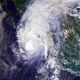
Hurricane Ismael was a weak, but deadly Pacific hurricane
that killed over one hundred people in northern Mexico
in September of the 1995 Pacific hurricane season
. It developed from a persistent area of deep convection
on September 12, and steadily strengthened as it moved to the north-northwest. Ismael attained hurricane status on September 14 while located 210 miles (340 km) off the coast of Mexico. It continued to the north, and after passing a short distance east of Baja California
it made landfall on Topolobampo
in the state of Sinaloa
with winds of 80 mph (130 km/h). Ismael rapidly weakened over land, and dissipated on September 16 over northwestern Mexico. The remnants entered the United States
and extended eastward into the Mid-Atlantic States
.
Offshore, Ismael produced waves of up to 30 feet (9 m) in height. Hundreds of fishermen were unprepared for the hurricane, which was expected to move more slowly, and as a result 52 ships were wrecked, killing 57 fishermen. On land, Ismael caused 59 deaths in mainland Mexico
and resulted in $26 million in damage (1995 USD, $ USD). The hurricane destroyed thousands of houses, leaving 30,000 people homeless. Moisture from the storm extended into the United States
, causing heavy rainfall and localized moderate damage in southeastern New Mexico
.
on September 9. It moved west-northwestward, and after three days without further organization a circulation developed off the southwest coast of Mexico
. The system quickly organized, resulting in Dvorak classifications
beginning later that day. Convective banding became better organized, and late on September 12 it developed into Tropical Depression Ten while located about 350 miles (563.3 km) south-southwest of Manzanillo, Colima
. The depression moved to the northwest, and following an increase in deep convection it intensified into Tropical Storm Ismael early on September 13.
Upon attaining tropical storm status, Ismael was located in an area of warm water temperatures with well-established upper-level outflow. Initially the storm moved to the northwest, though in response to the interaction with an upper-level low over Baja California
Ismael gradually turned to the north. Such a change in motion was not operationally predicted by forecasters, though they noted uncertainty in Ismael's track due to the low. Ismael steadily strengthened as it moved northward, though it failed to organize significantly; early on September 14 the center remained poorly defined despite winds of 70 mi/h. However, the outflow remained well-organized as it remained over warm waters. Ismael became better organized, and later on September 14 it intensified into a hurricane while located 210 miles (340 km) west-southwest of Puerto Vallarta
.
 Ismael quickly developed a poorly defined eye
, and six hours after becoming a hurricane it reached a peak intensity of 80 mi/h. Steered between a mid- to upper-level trough
to its west and a ridge
to its east, Ismael accelerated as it moved just west of due north. Late on September 14 Ismael passed 65 miles (100 km) east of Cabo San Lucas
. The hurricane maintained its strength as it continued northward, and made landfall on Topolobampo
in the state of Sinaloa
on September 15. Ismael rapidly weakened as the circulation crossed the high terrain of the Sierra Madre Occidental
, and it dissipated early on September 16 about 55 miles (95 km) south of the Mexico/United States
border. The remnants of Ismael continued northward, and moisture from the storm extended over the southwestern United States eastward through the Mid-Atlantic States
.
. However, when a northward motion became apparent, the government of Mexico
issued a tropical storm warning
from Manzanillo, Colima
, to Cabo Corrientes
and for the Islas Marias
. Shortly thereafter, the warning was extended to Los Mochis
and issued for the eastern coast of Baja California Sur
south of 25° N. Ten hours before Ismael made its final landfall, the Mexican government issued a hurricane warning from Mazatlán
to Los Mochis
. Prior to the arrival of the hurricane, 1,572 people evacuated to five emergency shelters.
 Hurricane Ismael produced 30 foot (9 m) waves over the Gulf of California
and coastal waters off of Mexico
. The hurricane, which was forecast to move more slowly, left hundreds of fisherman unprepared due to deficient communications between the boats and harbor authorities. As a result 52 boats were wrecked, of which 20 sank. 57 fishermen died offshore, with dozens washing ashore as the high tides receded. About 150 fishermen survived the storm by waiting on islands, sandbars, or disabled fishing boats. Navy
rescue teams and other fishermen searched for days off the Mexican coast to find victims and survivors from the storm.
While moving through northwestern Mexico
, Hurricane Ismael dropped moderate to heavy rainfall including a state record of 7.76 inches (197.1 mm) in Sinaloa
, resulting in the flooding of four municipalities
. In one municipality, the passage of the hurricane destroyed 373 cardboard houses and damaged 4,790 others. The passage of the hurricane left 177 houses without drinking water and left four municipalities without power.
Damage was heaviest where the hurricane made landfall. In Los Mochis
, the winds from Ismael knocked down houses and telephone poles, though no deaths were reported. 59 people were killed in Sinaloa.
Ismael produced heavy rainfall further to the north, peaking at 10.9 inches (276 mm) in Sonora
. Severe flooding was reported in Huatabampo
. The hurricane directly affected 24,111 people in 8 municipalities
. Throughout Sonora, the strong winds destroyed 4,728 houses and removed the roofs of 6,827 homes. The hurricane also destroyed 107 schools and 2 health centers in the state. The passage of Hurricane Ismael damaged high-tension power lines and cable lines, causing interruptions to the communication system. The hurricane also weakened 2,163 miles (3,481 km) of gravel roads and damaged about 100 miles (165 km) of paved highways. 250 people lost their jobs in Sonora due to sunken or damaged fishing boats. In addition, about 83 sq. miles (215 km²) of crop lands were impacted. Damage in Sonora amounted to $8.6 million (1995 USD, $50 million 1995 MXN
, $ USD).
Throughout Mexico the hurricane left 30,000 people homeless. Including offshore casualties, Ismael caused at least 116 deaths and damage totaling to $26 million (1995 USD, $197 million 1995 MXN, $ USD).
Moisture from the remnants of Ismael extended into southwestern Arizona
and southern New Mexico
. The storm dropped heavy precipitation near the New Mexico/Texas
border, including a peak total of 8.53 inches (216.7 mm) in Hobbs, New Mexico
. In addition, there were unofficial estimates of over 10 inches (254 mm). The rainfall led to flooding of roads and buildings. Multiple highways and railroads were closed due to washout
s. Damaged totaled to $250,000 (1995 USD) in New Mexico. In Lubbock, Texas
, the rainfall led to flash flooding, closing many intersections and roads. The remnants of Ismael produced over 3 inches (76.2 mm) of rain in southwestern Oklahoma
and northern Arkansas
, with moisture extending eastward into the Mid-Atlantic States
. There, the rainfall helped to relieve drought conditions.
. The Mexican government allocated about $ (1995 USD, $ 1995 MXN, $ USD) in funds for the restoration of houses and the overall infrastructure. Officials distributed 4,800 sheets, 500 cushions, and 1,500 blankets to hurricane victims. All sunken ships and drowned bodies were ultimately recovered by divers.
Due to the damage and deaths, the World Meteorological Organization retired the name Ismael with Israel, another Spanish name beginning with the letter "I" set to be used in the 2001 Pacific hurricane season
. During the 2001 season, a reporter stationed in Israel
felt offended from the name choice, and the president of the Anti-Defamation League
felt it was insensitive. Hundreds of people sent e-mails or called the National Hurricane Center
, and as a result Max Mayfield
called the members of the World Meteorological Organization. The name Israel was replaced with Ivo during the season. Ivo wasn't retired after the 2001 or 2007 seasons, and it will next be used in the 2013 season.
Pacific hurricane
A Pacific hurricane or tropical storm is a tropical cyclone that develops in the northeastern part of the Pacific Ocean. For organizational purposes, the northern Pacific Ocean is divided into three regions: the eastern, , central , and western...
that killed over one hundred people in northern Mexico
Mexico
The United Mexican States , commonly known as Mexico , is a federal constitutional republic in North America. It is bordered on the north by the United States; on the south and west by the Pacific Ocean; on the southeast by Guatemala, Belize, and the Caribbean Sea; and on the east by the Gulf of...
in September of the 1995 Pacific hurricane season
1995 Pacific hurricane season
The 1995 Pacific hurricane season was the least active Pacific hurricane season since 1979. Of the eleven tropical cyclones that formed during the season, four affected land, with the most notable storm of the season being Hurricane Ismael, which killed at least 116 people in Mexico...
. It developed from a persistent area of deep convection
Atmospheric convection
Atmospheric convection is the result of a parcel-environment instability, or temperature difference, layer in the atmosphere. Different lapse rates within dry and moist air lead to instability. Mixing of air during the day which expands the height of the planetary boundary layer leads to...
on September 12, and steadily strengthened as it moved to the north-northwest. Ismael attained hurricane status on September 14 while located 210 miles (340 km) off the coast of Mexico. It continued to the north, and after passing a short distance east of Baja California
Baja California Sur
Baja California Sur , is one of the 31 states which, with the Federal District, comprise the 32 Federal Entities of Mexico. Before becoming a state on October 8, 1974, the area was known as the South Territory of Baja California. It has an area of , or 3.57% of the land mass of Mexico and comprises...
it made landfall on Topolobampo
Topolobampo
Topolobampo is a port on the Gulf of California in northwestern Sinaloa, Mexico. It is the fourth-largest town in the municipality of Ahome , reporting a 2005 census population of 6,032 inhabitants....
in the state of Sinaloa
Sinaloa
Sinaloa officially Estado Libre y Soberano de Sinaloa is one of the 31 states which, with the Federal District, comprise the 32 Federal Entities of Mexico. It is divided in 18 municipalities and its capital city is Culiacán Rosales....
with winds of 80 mph (130 km/h). Ismael rapidly weakened over land, and dissipated on September 16 over northwestern Mexico. The remnants entered the United States
United States
The United States of America is a federal constitutional republic comprising fifty states and a federal district...
and extended eastward into the Mid-Atlantic States
Mid-Atlantic States
The Mid-Atlantic states, also called middle Atlantic states or simply the mid Atlantic, form a region of the United States generally located between New England and the South...
.
Offshore, Ismael produced waves of up to 30 feet (9 m) in height. Hundreds of fishermen were unprepared for the hurricane, which was expected to move more slowly, and as a result 52 ships were wrecked, killing 57 fishermen. On land, Ismael caused 59 deaths in mainland Mexico
Mexico
The United Mexican States , commonly known as Mexico , is a federal constitutional republic in North America. It is bordered on the north by the United States; on the south and west by the Pacific Ocean; on the southeast by Guatemala, Belize, and the Caribbean Sea; and on the east by the Gulf of...
and resulted in $26 million in damage (1995 USD, $ USD). The hurricane destroyed thousands of houses, leaving 30,000 people homeless. Moisture from the storm extended into the United States
United States
The United States of America is a federal constitutional republic comprising fifty states and a federal district...
, causing heavy rainfall and localized moderate damage in southeastern New Mexico
New Mexico
New Mexico is a state located in the southwest and western regions of the United States. New Mexico is also usually considered one of the Mountain States. With a population density of 16 per square mile, New Mexico is the sixth-most sparsely inhabited U.S...
.
Meteorological history
A poorly organized area of convection persisted about 170 miles (273.6 km) off the southern coast of GuatemalaGuatemala
Guatemala is a country in Central America bordered by Mexico to the north and west, the Pacific Ocean to the southwest, Belize to the northeast, the Caribbean to the east, and Honduras and El Salvador to the southeast...
on September 9. It moved west-northwestward, and after three days without further organization a circulation developed off the southwest coast of Mexico
Mexico
The United Mexican States , commonly known as Mexico , is a federal constitutional republic in North America. It is bordered on the north by the United States; on the south and west by the Pacific Ocean; on the southeast by Guatemala, Belize, and the Caribbean Sea; and on the east by the Gulf of...
. The system quickly organized, resulting in Dvorak classifications
Dvorak technique
The Dvorak technique is a widely used system to subjectively estimate tropical cyclone intensity based solely on visible and infrared satellite images. Several agencies issue Dvorak intensity numbers for cyclones of sufficient intensity...
beginning later that day. Convective banding became better organized, and late on September 12 it developed into Tropical Depression Ten while located about 350 miles (563.3 km) south-southwest of Manzanillo, Colima
Manzanillo, Colima
The name Manzanillo refers to the city as well as its surrounding municipality in the Mexican state of Colima. The city, located on the Pacific Ocean, contains Mexico's busiest port. Manzanillo was the third port created by the Spanish in the Pacific during the New Spain period...
. The depression moved to the northwest, and following an increase in deep convection it intensified into Tropical Storm Ismael early on September 13.
Upon attaining tropical storm status, Ismael was located in an area of warm water temperatures with well-established upper-level outflow. Initially the storm moved to the northwest, though in response to the interaction with an upper-level low over Baja California
Baja California Peninsula
The Baja California peninsula , is a peninsula in northwestern Mexico. Its land mass separates the Pacific Ocean from the Gulf of California. The Peninsula extends from Mexicali, Baja California in the north to Cabo San Lucas, Baja California Sur in the south.The total area of the Baja California...
Ismael gradually turned to the north. Such a change in motion was not operationally predicted by forecasters, though they noted uncertainty in Ismael's track due to the low. Ismael steadily strengthened as it moved northward, though it failed to organize significantly; early on September 14 the center remained poorly defined despite winds of 70 mi/h. However, the outflow remained well-organized as it remained over warm waters. Ismael became better organized, and later on September 14 it intensified into a hurricane while located 210 miles (340 km) west-southwest of Puerto Vallarta
Puerto Vallarta
Puerto Vallarta is a Mexican balneario resort city situated on the Pacific Ocean's Bahía de Banderas.The 2010 census reported Puerto Vallarta's population as 255,725 making it the sixth-largest city in the state of Jalisco...
.
Eye (cyclone)
The eye is a region of mostly calm weather found at the center of strong tropical cyclones. The eye of a storm is a roughly circular area and typically 30–65 km in diameter. It is surrounded by the eyewall, a ring of towering thunderstorms where the second most severe weather of a cyclone...
, and six hours after becoming a hurricane it reached a peak intensity of 80 mi/h. Steered between a mid- to upper-level trough
Trough (meteorology)
A trough is an elongated region of relatively low atmospheric pressure, often associated with fronts.Unlike fronts, there is not a universal symbol for a trough on a weather chart. The weather charts in some countries or regions mark troughs by a line. In the United States, a trough may be marked...
to its west and a ridge
Ridge (meteorology)
A ridge is an elongated region of relatively high atmospheric pressure, the opposite of a trough....
to its east, Ismael accelerated as it moved just west of due north. Late on September 14 Ismael passed 65 miles (100 km) east of Cabo San Lucas
Cabo San Lucas
Cabo San Lucas , commonly called Cabo, is a city at the southern tip of the Baja California peninsula, in the municipality of Los Cabos in the Mexican state of Baja California Sur. As of the 2010 census, the population was 68,463 people...
. The hurricane maintained its strength as it continued northward, and made landfall on Topolobampo
Topolobampo
Topolobampo is a port on the Gulf of California in northwestern Sinaloa, Mexico. It is the fourth-largest town in the municipality of Ahome , reporting a 2005 census population of 6,032 inhabitants....
in the state of Sinaloa
Sinaloa
Sinaloa officially Estado Libre y Soberano de Sinaloa is one of the 31 states which, with the Federal District, comprise the 32 Federal Entities of Mexico. It is divided in 18 municipalities and its capital city is Culiacán Rosales....
on September 15. Ismael rapidly weakened as the circulation crossed the high terrain of the Sierra Madre Occidental
Sierra Madre Occidental
The Sierra Madre Occidental is a mountain range in western Mexico.-Setting:The range runs north to south, from just south of the Sonora–Arizona border southeast through eastern Sonora, western Chihuahua, Sinaloa, Durango, Zacatecas, Nayarit, Jalisco, Aguascalientes to Guanajuato, where it joins...
, and it dissipated early on September 16 about 55 miles (95 km) south of the Mexico/United States
United States
The United States of America is a federal constitutional republic comprising fifty states and a federal district...
border. The remnants of Ismael continued northward, and moisture from the storm extended over the southwestern United States eastward through the Mid-Atlantic States
Mid-Atlantic States
The Mid-Atlantic states, also called middle Atlantic states or simply the mid Atlantic, form a region of the United States generally located between New England and the South...
.
Preparations
Initially, Hurricane Ismael was predicted to remain over the open waters of the Pacific OceanPacific Ocean
The Pacific Ocean is the largest of the Earth's oceanic divisions. It extends from the Arctic in the north to the Southern Ocean in the south, bounded by Asia and Australia in the west, and the Americas in the east.At 165.2 million square kilometres in area, this largest division of the World...
. However, when a northward motion became apparent, the government of Mexico
Mexico
The United Mexican States , commonly known as Mexico , is a federal constitutional republic in North America. It is bordered on the north by the United States; on the south and west by the Pacific Ocean; on the southeast by Guatemala, Belize, and the Caribbean Sea; and on the east by the Gulf of...
issued a tropical storm warning
Tropical cyclone warnings and watches
Warnings and watches are two levels of alert issued by national weather forecasting bodies to coastal areas threatened by the imminent approach of a tropical cyclone of tropical storm or hurricane intensity. They are notices to the local population and civil authorities to make appropriate...
from Manzanillo, Colima
Manzanillo, Colima
The name Manzanillo refers to the city as well as its surrounding municipality in the Mexican state of Colima. The city, located on the Pacific Ocean, contains Mexico's busiest port. Manzanillo was the third port created by the Spanish in the Pacific during the New Spain period...
, to Cabo Corrientes
Cabo Corrientes
Cabo Corrientes is a cape on the Pacific coast of the Mexican state of Jalisco. It marks the southernmost point of the Bahía de Banderas, upon which the port and resort city of Puerto Vallarta stands. The municipality in which the cape lies is also called Cabo Corrientes.Cabo Corrientes is a...
and for the Islas Marias
Islas Marías
The Islas Marías are an archipelago of four islands that belong to Mexico. They are located in the Pacific Ocean, some off the coast of the state of Nayarit. They are part of the municipality of San Blas, Nayarit...
. Shortly thereafter, the warning was extended to Los Mochis
Los Mochis
Los Mochis is a coastal city in northern Sinaloa, Mexico. It serves as the municipal seat of the municipality of Ahome. As of the 2010 census, the population was 256,613, which was 61 percent of the municipality's population....
and issued for the eastern coast of Baja California Sur
Baja California Sur
Baja California Sur , is one of the 31 states which, with the Federal District, comprise the 32 Federal Entities of Mexico. Before becoming a state on October 8, 1974, the area was known as the South Territory of Baja California. It has an area of , or 3.57% of the land mass of Mexico and comprises...
south of 25° N. Ten hours before Ismael made its final landfall, the Mexican government issued a hurricane warning from Mazatlán
Mazatlán
Mazatlán is a city in the Mexican state of Sinaloa; the surrounding municipio for which the city serves as the municipal seat is Mazatlán Municipality. It is located at on the Pacific coast, across from the southernmost tip of the Baja California peninsula.Mazatlán is a Nahuatl word meaning...
to Los Mochis
Los Mochis
Los Mochis is a coastal city in northern Sinaloa, Mexico. It serves as the municipal seat of the municipality of Ahome. As of the 2010 census, the population was 256,613, which was 61 percent of the municipality's population....
. Prior to the arrival of the hurricane, 1,572 people evacuated to five emergency shelters.
Impact
Gulf of California
The Gulf of California is a body of water that separates the Baja California Peninsula from the Mexican mainland...
and coastal waters off of Mexico
Mexico
The United Mexican States , commonly known as Mexico , is a federal constitutional republic in North America. It is bordered on the north by the United States; on the south and west by the Pacific Ocean; on the southeast by Guatemala, Belize, and the Caribbean Sea; and on the east by the Gulf of...
. The hurricane, which was forecast to move more slowly, left hundreds of fisherman unprepared due to deficient communications between the boats and harbor authorities. As a result 52 boats were wrecked, of which 20 sank. 57 fishermen died offshore, with dozens washing ashore as the high tides receded. About 150 fishermen survived the storm by waiting on islands, sandbars, or disabled fishing boats. Navy
Navy
A navy is the branch of a nation's armed forces principally designated for naval and amphibious warfare; namely, lake- or ocean-borne combat operations and related functions...
rescue teams and other fishermen searched for days off the Mexican coast to find victims and survivors from the storm.
While moving through northwestern Mexico
Mexico
The United Mexican States , commonly known as Mexico , is a federal constitutional republic in North America. It is bordered on the north by the United States; on the south and west by the Pacific Ocean; on the southeast by Guatemala, Belize, and the Caribbean Sea; and on the east by the Gulf of...
, Hurricane Ismael dropped moderate to heavy rainfall including a state record of 7.76 inches (197.1 mm) in Sinaloa
Sinaloa
Sinaloa officially Estado Libre y Soberano de Sinaloa is one of the 31 states which, with the Federal District, comprise the 32 Federal Entities of Mexico. It is divided in 18 municipalities and its capital city is Culiacán Rosales....
, resulting in the flooding of four municipalities
Municipalities of Sinaloa
The Mexican state of Sinaloa is divided into 18 municipios :...
. In one municipality, the passage of the hurricane destroyed 373 cardboard houses and damaged 4,790 others. The passage of the hurricane left 177 houses without drinking water and left four municipalities without power.
Damage was heaviest where the hurricane made landfall. In Los Mochis
Los Mochis
Los Mochis is a coastal city in northern Sinaloa, Mexico. It serves as the municipal seat of the municipality of Ahome. As of the 2010 census, the population was 256,613, which was 61 percent of the municipality's population....
, the winds from Ismael knocked down houses and telephone poles, though no deaths were reported. 59 people were killed in Sinaloa.
Ismael produced heavy rainfall further to the north, peaking at 10.9 inches (276 mm) in Sonora
Sonora
Sonora officially Estado Libre y Soberano de Sonora is one of the 31 states which, with the Federal District, comprise the 32 Federal Entities of Mexico. It is divided into 72 municipalities; the capital city is Hermosillo....
. Severe flooding was reported in Huatabampo
Huatabampo
Huatabampo is a city and municipality in the state of Sonora, in northwestern Mexico. It is situated on the Gulf of California, near the mouth of the Mayo River. It is located at latitude . Huatabampo is 34 km southwest of Navojoa via Sonora State Highway 56 and Sonora State Highway 149...
. The hurricane directly affected 24,111 people in 8 municipalities
Municipalities of Sonora
The Mexican state of Sonorais divided into 72 municipalities:...
. Throughout Sonora, the strong winds destroyed 4,728 houses and removed the roofs of 6,827 homes. The hurricane also destroyed 107 schools and 2 health centers in the state. The passage of Hurricane Ismael damaged high-tension power lines and cable lines, causing interruptions to the communication system. The hurricane also weakened 2,163 miles (3,481 km) of gravel roads and damaged about 100 miles (165 km) of paved highways. 250 people lost their jobs in Sonora due to sunken or damaged fishing boats. In addition, about 83 sq. miles (215 km²) of crop lands were impacted. Damage in Sonora amounted to $8.6 million (1995 USD, $50 million 1995 MXN
Mexican peso
The peso is the currency of Mexico. Modern peso and dollar currencies have a common origin in the 15th–19th century Spanish dollar, most continuing to use its sign, "$". The Mexican peso is the 12th most traded currency in the world, the third most traded in the Americas, and by far the most...
, $ USD).
Throughout Mexico the hurricane left 30,000 people homeless. Including offshore casualties, Ismael caused at least 116 deaths and damage totaling to $26 million (1995 USD, $197 million 1995 MXN, $ USD).
Moisture from the remnants of Ismael extended into southwestern Arizona
Arizona
Arizona ; is a state located in the southwestern region of the United States. It is also part of the western United States and the mountain west. The capital and largest city is Phoenix...
and southern New Mexico
New Mexico
New Mexico is a state located in the southwest and western regions of the United States. New Mexico is also usually considered one of the Mountain States. With a population density of 16 per square mile, New Mexico is the sixth-most sparsely inhabited U.S...
. The storm dropped heavy precipitation near the New Mexico/Texas
Texas
Texas is the second largest U.S. state by both area and population, and the largest state by area in the contiguous United States.The name, based on the Caddo word "Tejas" meaning "friends" or "allies", was applied by the Spanish to the Caddo themselves and to the region of their settlement in...
border, including a peak total of 8.53 inches (216.7 mm) in Hobbs, New Mexico
Hobbs, New Mexico
Hobbs is a city in Lea County, New Mexico, United States. The population was 28,657 at the 2000 census.Hobbs is the principal city of the Hobbs, New Mexico Micropolitan Statistical Area, which includes all of Lea County.-Geography:...
. In addition, there were unofficial estimates of over 10 inches (254 mm). The rainfall led to flooding of roads and buildings. Multiple highways and railroads were closed due to washout
Washout
A washout is the sudden erosion of soft soil or other support surfaces by a gush of water, usually occurring during a heavy downpour of rain or other stream flooding. These downpours may occur locally in a thunderstorm , or over a large area, such as following the landfall of a tropical cyclone...
s. Damaged totaled to $250,000 (1995 USD) in New Mexico. In Lubbock, Texas
Lubbock, Texas
Lubbock is a city in and the county seat of Lubbock County, Texas, United States. The city is located in the northwestern part of the state, a region known historically as the Llano Estacado, and the home of Texas Tech University and Lubbock Christian University...
, the rainfall led to flash flooding, closing many intersections and roads. The remnants of Ismael produced over 3 inches (76.2 mm) of rain in southwestern Oklahoma
Oklahoma
Oklahoma is a state located in the South Central region of the United States of America. With an estimated 3,751,351 residents as of the 2010 census and a land area of 68,667 square miles , Oklahoma is the 28th most populous and 20th-largest state...
and northern Arkansas
Arkansas
Arkansas is a state located in the southern region of the United States. Its name is an Algonquian name of the Quapaw Indians. Arkansas shares borders with six states , and its eastern border is largely defined by the Mississippi River...
, with moisture extending eastward into the Mid-Atlantic States
Mid-Atlantic States
The Mid-Atlantic states, also called middle Atlantic states or simply the mid Atlantic, form a region of the United States generally located between New England and the South...
. There, the rainfall helped to relieve drought conditions.
Aftermath
Following the passage of the hurricane, reinforcement workers quickly repaired the communication network, and other workers distributed aid to victims in SonoraSonora
Sonora officially Estado Libre y Soberano de Sonora is one of the 31 states which, with the Federal District, comprise the 32 Federal Entities of Mexico. It is divided into 72 municipalities; the capital city is Hermosillo....
. The Mexican government allocated about $ (1995 USD, $ 1995 MXN, $ USD) in funds for the restoration of houses and the overall infrastructure. Officials distributed 4,800 sheets, 500 cushions, and 1,500 blankets to hurricane victims. All sunken ships and drowned bodies were ultimately recovered by divers.
Due to the damage and deaths, the World Meteorological Organization retired the name Ismael with Israel, another Spanish name beginning with the letter "I" set to be used in the 2001 Pacific hurricane season
2001 Pacific hurricane season
The 2001 Pacific hurricane season was an event in tropical cyclone meteorology. The most notable storm that year was Hurricane Juliette, which caused devastating floods in Baja California, leading to 12 fatalities and $400 million worth of damage...
. During the 2001 season, a reporter stationed in Israel
Israel
The State of Israel is a parliamentary republic located in the Middle East, along the eastern shore of the Mediterranean Sea...
felt offended from the name choice, and the president of the Anti-Defamation League
Anti-Defamation League
The Anti-Defamation League is an international non-governmental organization based in the United States. Describing itself as "the nation's premier civil rights/human relations agency", the ADL states that it "fights anti-Semitism and all forms of bigotry, defends democratic ideals and protects...
felt it was insensitive. Hundreds of people sent e-mails or called the National Hurricane Center
National Hurricane Center
The National Hurricane Center , located at Florida International University in Miami, Florida, is the division of the National Weather Service responsible for tracking and predicting weather systems within the tropics between the Prime Meridian and the 140th meridian west poleward to the 30th...
, and as a result Max Mayfield
Max Mayfield
Britt Max Mayfield is a meteorologist who served as the director of the National Hurricane Center from 2000 to 2007...
called the members of the World Meteorological Organization. The name Israel was replaced with Ivo during the season. Ivo wasn't retired after the 2001 or 2007 seasons, and it will next be used in the 2013 season.
See also
- List of Pacific hurricanes
- List of retired Pacific hurricane names