
.gif)
Hurricane Gladys (1964)
Encyclopedia
Hurricane Gladys was the ninth tropical cyclone (including two unnamed tropical storms), seventh named storm, fourth hurricane and fourth major hurricane of the 1964 Atlantic hurricane season
. Gladys formed from on September 13, 1964 as a tropical depression and moved westward where it quickly became a Category 4 hurricane
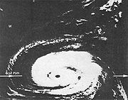
. Gladys reached a peak intensity of 145 mph (225 km/h) before recurving to the northeast and brushing past eastern North Carolina
and Atlantic Canada
. Gladys then became extratropical dissipated on September 25.
Although the storm stayed offshore, Gladys managed to cause moderate beach erosion and flood damage in the Outer Banks
of North Carolina
. Overall damage was minor and there was only one indirect fatality as the result of the storm.
moved off the coast of Africa
on September 9 and moved westward across the Atlantic Ocean
. On September 13, a ship reported winds of 63 mph (101 km/h) confirming that the disturbance had rapidly intensified to a tropical storm. As a result, the National Hurricane Center
named the storm Gladys. A hurricane hunter plane flew into Gladys but was unable to obtain wind data due to darkness.
The following day, the hurricane hunter plane flew into Gladys again and the crew determined that the storm had rapidly reached hurricane status as it moved west-northwest at 18 mph. Gladys continued on that heading as it reached Category 4 status. On September 17, Gladys winds peaked at 145 mph (225 km/h) and the barometric pressure dropped to 945 mb.
On September 19 a weak trough
caused Gladys to turn northward and weaken to a Category 3 hurricane and later to a Category 2 hurricane. Gladys drifted northward for 48 hours before turning to the northwest again. Gladys then turned to the northeast on September 23 in response of a developing area of low pressure over the Great Lakes
. The center of the storm reached its closest proximity to the East Coast of the United States
by 150 miles (241 km). Gladys then weakened to a minimal hurricane as it continued moving northeastward. The hurricane accelerated rapidly and became extratropical on September 23. The extratropical remnants of Gladys brushed past Nova Scotia
and passed over Newfoundland on September 24 prior to dissipating on September 25.
 As Gladys strengthened in the Atlantic Ocean
, forecasters at the National Hurricane Center
predicted that the storm will bring high surf to areas as far north as North Carolina
and suggested that Gladys might head towards northern Florida
as the storm was on a similar path as Hurricane Dora
. As a result, forecasters advised residents along the southeastern coast of the United States
and small craft advisories were issued. On September 20, the concern of Gladys hitting Florida
dwindled as the storm turned northeast and small craft advisories were issued for the Bahamas.
On September 22, Gladys turned back towards the northwest, prompting forecasters at the National Hurricane Center
to place the states of North Carolina
, Virginia
and Mid Atlantic
under a hurricane watch. Gale warnings and small craft advisories were issued on September 23 from Massachusetts
to Rhode Island
. In Rhode Island
, ships of the United States Navy
were diverted to Narraganselt Bay
as a precaution. At 11 p.m. EDT, the gale warnings for New England
were lowered as Gladys turned northeastward away from the coast however, small water craft were advised to remain in port until the seas subside.
, northern Bahamas and coastal sections of Florida
and Georgia
.
was minimal as the center of the hurricane was a considerable distance from the coastline. The only effects Gladys brought to South Carolina
was an 1 inch (25.4 mm) of rainfall which was reported in Myrtle Beach and storm tide
s two feet (0.6 meters) above normal.
In North Carolina
, Gladys' large wind field produced strong tropical storm force winds near Manteo
. Waves produced by the strong winds flooded a highway leading away from Manteo. Near Cape Hatteras
, a weather station recorded winds of 40 mph (65 km/h) with gust up to 41 mph (66 km/h) and tides 2-2.5 feet (0.6-0.76 meters) above normal. The abnormal tides and heavy wave action flooded two small villages, leaving many homes and buildings under 2 feet (0.6 meters) of water and washed away grasses that were planted to stabilize the sand dunes. A weather station in Wilmington
reported winds of 25 mph (40 km/h) with a peak gust of 28 mph (45 km/h) and tides 2–3 feet (0.6-0.9 meters) above normal. Elsewhere in the Outer Banks
, high winds caused a mobile home
to fall off its foundations and blew down two television antennas.
In Virginia
, a weather station in Norfolk
recorded gusts of 38-44 mph (61–71 km/h), a barometric pressure of 29.71 inches (1006 millibars) and .17 inches (4.31 mm) of rain
. A weather station in Cape Henry
recorded sustained winds of 42 mph (68 km/h)and rainfall of .02 inches (0.5 mm). Coastal sections of southeastern Virginia
experienced tides 2.2-6.1 feet (0.6-1.8 meters) above normal, resulting in minor tidal flooding. One indirect fatality was attributed from Gladys when a man suffered fatal wounds to his throat due to flying debris.
, New York
and Massachusetts
. In Rhode Island
, the outer bands of Gladys produced light rainfall of .38 inches (9.6 mm) across the state. In Narragansett, Rhode Island, a boy was washed into the sea by the waves and was rescued by the United States Coast Guard
servicemen who dove into the water to rescue the boy after two previous attempts to rescue him failed. The outer bands of Gladys also lashed Bermuda
with winds but little damage if any was reported. In Atlantic Canada
, Gladys passed over Newfoundland as a 70 mph (113 km/h) extratropical storm but no damage was reported.
1964 Atlantic hurricane season
The 1964 Atlantic hurricane season officially began on June 15, 1964, and lasted until November 15, 1964. These dates conventionally delimit the period of each year when most tropical cyclones form in the Atlantic basin...
. Gladys formed from on September 13, 1964 as a tropical depression and moved westward where it quickly became a Category 4 hurricane
Saffir-Simpson Hurricane Scale
The Saffir–Simpson Hurricane Scale , or the Saffir–Simpson Hurricane Wind Scale , classifies hurricanes — Western Hemisphere tropical cyclones that exceed the intensities of tropical depressions and tropical storms — into five categories distinguished by the intensities of their sustained winds...
. Gladys reached a peak intensity of 145 mph (225 km/h) before recurving to the northeast and brushing past eastern North Carolina
North Carolina
North Carolina is a state located in the southeastern United States. The state borders South Carolina and Georgia to the south, Tennessee to the west and Virginia to the north. North Carolina contains 100 counties. Its capital is Raleigh, and its largest city is Charlotte...
and Atlantic Canada
Atlantic Canada
Atlantic Canada is the region of Canada comprising the four provinces located on the Atlantic coast, excluding Quebec: the three Maritime provinces – New Brunswick, Prince Edward Island, and Nova Scotia – and Newfoundland and Labrador...
. Gladys then became extratropical dissipated on September 25.
Although the storm stayed offshore, Gladys managed to cause moderate beach erosion and flood damage in the Outer Banks
Outer Banks
The Outer Banks is a 200-mile long string of narrow barrier islands off the coast of North Carolina, beginning in the southeastern corner of Virginia Beach on the east coast of the United States....
of North Carolina
North Carolina
North Carolina is a state located in the southeastern United States. The state borders South Carolina and Georgia to the south, Tennessee to the west and Virginia to the north. North Carolina contains 100 counties. Its capital is Raleigh, and its largest city is Charlotte...
. Overall damage was minor and there was only one indirect fatality as the result of the storm.
Meteorological history
A weak tropical waveTropical wave
Tropical waves, easterly waves, or tropical easterly waves, also known as African easterly waves in the Atlantic region, are a type of atmospheric trough, an elongated area of relatively low air pressure, oriented north to south, which move from east to west across the tropics causing areas of...
moved off the coast of Africa
Africa
Africa is the world's second largest and second most populous continent, after Asia. At about 30.2 million km² including adjacent islands, it covers 6% of the Earth's total surface area and 20.4% of the total land area...
on September 9 and moved westward across the Atlantic Ocean
Atlantic Ocean
The Atlantic Ocean is the second-largest of the world's oceanic divisions. With a total area of about , it covers approximately 20% of the Earth's surface and about 26% of its water surface area...
. On September 13, a ship reported winds of 63 mph (101 km/h) confirming that the disturbance had rapidly intensified to a tropical storm. As a result, the National Hurricane Center
National Hurricane Center
The National Hurricane Center , located at Florida International University in Miami, Florida, is the division of the National Weather Service responsible for tracking and predicting weather systems within the tropics between the Prime Meridian and the 140th meridian west poleward to the 30th...
named the storm Gladys. A hurricane hunter plane flew into Gladys but was unable to obtain wind data due to darkness.
The following day, the hurricane hunter plane flew into Gladys again and the crew determined that the storm had rapidly reached hurricane status as it moved west-northwest at 18 mph. Gladys continued on that heading as it reached Category 4 status. On September 17, Gladys winds peaked at 145 mph (225 km/h) and the barometric pressure dropped to 945 mb.
On September 19 a weak trough
Trough (meteorology)
A trough is an elongated region of relatively low atmospheric pressure, often associated with fronts.Unlike fronts, there is not a universal symbol for a trough on a weather chart. The weather charts in some countries or regions mark troughs by a line. In the United States, a trough may be marked...
caused Gladys to turn northward and weaken to a Category 3 hurricane and later to a Category 2 hurricane. Gladys drifted northward for 48 hours before turning to the northwest again. Gladys then turned to the northeast on September 23 in response of a developing area of low pressure over the Great Lakes
Great Lakes
The Great Lakes are a collection of freshwater lakes located in northeastern North America, on the Canada – United States border. Consisting of Lakes Superior, Michigan, Huron, Erie, and Ontario, they form the largest group of freshwater lakes on Earth by total surface, coming in second by volume...
. The center of the storm reached its closest proximity to the East Coast of the United States
East Coast of the United States
The East Coast of the United States, also known as the Eastern Seaboard, refers to the easternmost coastal states in the United States, which touch the Atlantic Ocean and stretch up to Canada. The term includes the U.S...
by 150 miles (241 km). Gladys then weakened to a minimal hurricane as it continued moving northeastward. The hurricane accelerated rapidly and became extratropical on September 23. The extratropical remnants of Gladys brushed past Nova Scotia
Nova Scotia
Nova Scotia is one of Canada's three Maritime provinces and is the most populous province in Atlantic Canada. The name of the province is Latin for "New Scotland," but "Nova Scotia" is the recognized, English-language name of the province. The provincial capital is Halifax. Nova Scotia is the...
and passed over Newfoundland on September 24 prior to dissipating on September 25.
Preparations
Atlantic Ocean
The Atlantic Ocean is the second-largest of the world's oceanic divisions. With a total area of about , it covers approximately 20% of the Earth's surface and about 26% of its water surface area...
, forecasters at the National Hurricane Center
National Hurricane Center
The National Hurricane Center , located at Florida International University in Miami, Florida, is the division of the National Weather Service responsible for tracking and predicting weather systems within the tropics between the Prime Meridian and the 140th meridian west poleward to the 30th...
predicted that the storm will bring high surf to areas as far north as North Carolina
North Carolina
North Carolina is a state located in the southeastern United States. The state borders South Carolina and Georgia to the south, Tennessee to the west and Virginia to the north. North Carolina contains 100 counties. Its capital is Raleigh, and its largest city is Charlotte...
and suggested that Gladys might head towards northern Florida
Florida
Florida is a state in the southeastern United States, located on the nation's Atlantic and Gulf coasts. It is bordered to the west by the Gulf of Mexico, to the north by Alabama and Georgia and to the east by the Atlantic Ocean. With a population of 18,801,310 as measured by the 2010 census, it...
as the storm was on a similar path as Hurricane Dora
Hurricane Dora
Hurricane Dora was the first tropical cyclone on record to make landfall over the extreme northeast coast of Florida. Dora was also the first storm to produce hurricane force winds to Jacksonville, Florida in the almost 80 years of record keeping. Dora killed five people and left over...
. As a result, forecasters advised residents along the southeastern coast of the United States
United States
The United States of America is a federal constitutional republic comprising fifty states and a federal district...
and small craft advisories were issued. On September 20, the concern of Gladys hitting Florida
Florida
Florida is a state in the southeastern United States, located on the nation's Atlantic and Gulf coasts. It is bordered to the west by the Gulf of Mexico, to the north by Alabama and Georgia and to the east by the Atlantic Ocean. With a population of 18,801,310 as measured by the 2010 census, it...
dwindled as the storm turned northeast and small craft advisories were issued for the Bahamas.
On September 22, Gladys turned back towards the northwest, prompting forecasters at the National Hurricane Center
National Hurricane Center
The National Hurricane Center , located at Florida International University in Miami, Florida, is the division of the National Weather Service responsible for tracking and predicting weather systems within the tropics between the Prime Meridian and the 140th meridian west poleward to the 30th...
to place the states of North Carolina
North Carolina
North Carolina is a state located in the southeastern United States. The state borders South Carolina and Georgia to the south, Tennessee to the west and Virginia to the north. North Carolina contains 100 counties. Its capital is Raleigh, and its largest city is Charlotte...
, Virginia
Virginia
The Commonwealth of Virginia , is a U.S. state on the Atlantic Coast of the Southern United States. Virginia is nicknamed the "Old Dominion" and sometimes the "Mother of Presidents" after the eight U.S. presidents born there...
and Mid Atlantic
Mid Atlantic
Mid Atlantic can refer to:*The middle of the Atlantic Ocean*Mid-Atlantic Ridge, a tectonic plate boundary*Mid-Atlantic states, a region in the United States*Mid-Atlantic Athletic Conference, an athletic league in the United States...
under a hurricane watch. Gale warnings and small craft advisories were issued on September 23 from Massachusetts
Massachusetts
The Commonwealth of Massachusetts is a state in the New England region of the northeastern United States of America. It is bordered by Rhode Island and Connecticut to the south, New York to the west, and Vermont and New Hampshire to the north; at its east lies the Atlantic Ocean. As of the 2010...
to Rhode Island
Rhode Island
The state of Rhode Island and Providence Plantations, more commonly referred to as Rhode Island , is a state in the New England region of the United States. It is the smallest U.S. state by area...
. In Rhode Island
Rhode Island
The state of Rhode Island and Providence Plantations, more commonly referred to as Rhode Island , is a state in the New England region of the United States. It is the smallest U.S. state by area...
, ships of the United States Navy
United States Navy
The United States Navy is the naval warfare service branch of the United States Armed Forces and one of the seven uniformed services of the United States. The U.S. Navy is the largest in the world; its battle fleet tonnage is greater than that of the next 13 largest navies combined. The U.S...
were diverted to Narraganselt Bay
Rhode Island
The state of Rhode Island and Providence Plantations, more commonly referred to as Rhode Island , is a state in the New England region of the United States. It is the smallest U.S. state by area...
as a precaution. At 11 p.m. EDT, the gale warnings for New England
New England
New England is a region in the northeastern corner of the United States consisting of the six states of Maine, New Hampshire, Vermont, Massachusetts, Rhode Island, and Connecticut...
were lowered as Gladys turned northeastward away from the coast however, small water craft were advised to remain in port until the seas subside.
Impact
Hurricane Gladys' wind field extended 275 miles (443 km) from the center and produced rough seas that affected the eastern CaribbeanCaribbean
The Caribbean is a crescent-shaped group of islands more than 2,000 miles long separating the Gulf of Mexico and the Caribbean Sea, to the west and south, from the Atlantic Ocean, to the east and north...
, northern Bahamas and coastal sections of Florida
Florida
Florida is a state in the southeastern United States, located on the nation's Atlantic and Gulf coasts. It is bordered to the west by the Gulf of Mexico, to the north by Alabama and Georgia and to the east by the Atlantic Ocean. With a population of 18,801,310 as measured by the 2010 census, it...
and Georgia
Georgia (U.S. state)
Georgia is a state located in the southeastern United States. It was established in 1732, the last of the original Thirteen Colonies. The state is named after King George II of Great Britain. Georgia was the fourth state to ratify the United States Constitution, on January 2, 1788...
.
Carolinas and Virginia
Hurricane Gladys' effects on South CarolinaSouth Carolina
South Carolina is a state in the Deep South of the United States that borders Georgia to the south, North Carolina to the north, and the Atlantic Ocean to the east. Originally part of the Province of Carolina, the Province of South Carolina was one of the 13 colonies that declared independence...
was minimal as the center of the hurricane was a considerable distance from the coastline. The only effects Gladys brought to South Carolina
South Carolina
South Carolina is a state in the Deep South of the United States that borders Georgia to the south, North Carolina to the north, and the Atlantic Ocean to the east. Originally part of the Province of Carolina, the Province of South Carolina was one of the 13 colonies that declared independence...
was an 1 inch (25.4 mm) of rainfall which was reported in Myrtle Beach and storm tide
Storm tide
A storm tide is a tide with a high flood period caused by a storm. Storm tides can be a severe danger to the coast and the people living along the coast. The water level can rise to more than 5 meters above the normal tide....
s two feet (0.6 meters) above normal.
In North Carolina
North Carolina
North Carolina is a state located in the southeastern United States. The state borders South Carolina and Georgia to the south, Tennessee to the west and Virginia to the north. North Carolina contains 100 counties. Its capital is Raleigh, and its largest city is Charlotte...
, Gladys' large wind field produced strong tropical storm force winds near Manteo
Manteo, North Carolina
Manteo is a town in Dare County, North Carolina, United States, located on Roanoke Island. The population was 1,052 at the 2000 census. It is the county seat of Dare County.-Geography:...
. Waves produced by the strong winds flooded a highway leading away from Manteo. Near Cape Hatteras
Cape Hatteras
Cape Hatteras is a cape on the coast of North Carolina. It is the point that protrudes the farthest to the southeast along the northeast-to-southwest line of the Atlantic coast of North America...
, a weather station recorded winds of 40 mph (65 km/h) with gust up to 41 mph (66 km/h) and tides 2-2.5 feet (0.6-0.76 meters) above normal. The abnormal tides and heavy wave action flooded two small villages, leaving many homes and buildings under 2 feet (0.6 meters) of water and washed away grasses that were planted to stabilize the sand dunes. A weather station in Wilmington
Wilmington, North Carolina
Wilmington is a port city in and is the county seat of New Hanover County, North Carolina, United States. The population is 106,476 according to the 2010 Census, making it the eighth most populous city in the state of North Carolina...
reported winds of 25 mph (40 km/h) with a peak gust of 28 mph (45 km/h) and tides 2–3 feet (0.6-0.9 meters) above normal. Elsewhere in the Outer Banks
Outer Banks
The Outer Banks is a 200-mile long string of narrow barrier islands off the coast of North Carolina, beginning in the southeastern corner of Virginia Beach on the east coast of the United States....
, high winds caused a mobile home
Mobile home
Mobile homes or static caravans are prefabricated homes built in factories, rather than on site, and then taken to the place where they will be occupied...
to fall off its foundations and blew down two television antennas.
In Virginia
Virginia
The Commonwealth of Virginia , is a U.S. state on the Atlantic Coast of the Southern United States. Virginia is nicknamed the "Old Dominion" and sometimes the "Mother of Presidents" after the eight U.S. presidents born there...
, a weather station in Norfolk
Norfolk, Virginia
Norfolk is an independent city in the Commonwealth of Virginia in the United States. With a population of 242,803 as of the 2010 Census, it is Virginia's second-largest city behind neighboring Virginia Beach....
recorded gusts of 38-44 mph (61–71 km/h), a barometric pressure of 29.71 inches (1006 millibars) and .17 inches (4.31 mm) of rain
Rain
Rain is liquid precipitation, as opposed to non-liquid kinds of precipitation such as snow, hail and sleet. Rain requires the presence of a thick layer of the atmosphere to have temperatures above the melting point of water near and above the Earth's surface...
. A weather station in Cape Henry
Cape Henry
Cape Henry is a cape on the Atlantic shore of Virginia north of Virginia Beach. It is the southern boundary of the entrance to Chesapeake Bay.Across the mouth of the bay to the north is Cape Charles...
recorded sustained winds of 42 mph (68 km/h)and rainfall of .02 inches (0.5 mm). Coastal sections of southeastern Virginia
Virginia
The Commonwealth of Virginia , is a U.S. state on the Atlantic Coast of the Southern United States. Virginia is nicknamed the "Old Dominion" and sometimes the "Mother of Presidents" after the eight U.S. presidents born there...
experienced tides 2.2-6.1 feet (0.6-1.8 meters) above normal, resulting in minor tidal flooding. One indirect fatality was attributed from Gladys when a man suffered fatal wounds to his throat due to flying debris.
Northeast United States, Bermuda and Canada
High winds and strong ocean currents form Gladys produced heavy surf and beach erosion in New JerseyNew Jersey
New Jersey is a state in the Northeastern and Middle Atlantic regions of the United States. , its population was 8,791,894. It is bordered on the north and east by the state of New York, on the southeast and south by the Atlantic Ocean, on the west by Pennsylvania and on the southwest by Delaware...
, New York
New York
New York is a state in the Northeastern region of the United States. It is the nation's third most populous state. New York is bordered by New Jersey and Pennsylvania to the south, and by Connecticut, Massachusetts and Vermont to the east...
and Massachusetts
Massachusetts
The Commonwealth of Massachusetts is a state in the New England region of the northeastern United States of America. It is bordered by Rhode Island and Connecticut to the south, New York to the west, and Vermont and New Hampshire to the north; at its east lies the Atlantic Ocean. As of the 2010...
. In Rhode Island
Rhode Island
The state of Rhode Island and Providence Plantations, more commonly referred to as Rhode Island , is a state in the New England region of the United States. It is the smallest U.S. state by area...
, the outer bands of Gladys produced light rainfall of .38 inches (9.6 mm) across the state. In Narragansett, Rhode Island, a boy was washed into the sea by the waves and was rescued by the United States Coast Guard
United States Coast Guard
The United States Coast Guard is a branch of the United States Armed Forces and one of the seven U.S. uniformed services. The Coast Guard is a maritime, military, multi-mission service unique among the military branches for having a maritime law enforcement mission and a federal regulatory agency...
servicemen who dove into the water to rescue the boy after two previous attempts to rescue him failed. The outer bands of Gladys also lashed Bermuda
Bermuda
Bermuda is a British overseas territory in the North Atlantic Ocean. Located off the east coast of the United States, its nearest landmass is Cape Hatteras, North Carolina, about to the west-northwest. It is about south of Halifax, Nova Scotia, Canada, and northeast of Miami, Florida...
with winds but little damage if any was reported. In Atlantic Canada
Atlantic Canada
Atlantic Canada is the region of Canada comprising the four provinces located on the Atlantic coast, excluding Quebec: the three Maritime provinces – New Brunswick, Prince Edward Island, and Nova Scotia – and Newfoundland and Labrador...
, Gladys passed over Newfoundland as a 70 mph (113 km/h) extratropical storm but no damage was reported.