
.gif)
Vermilion River (Louisiana)
Encyclopedia
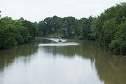
The Vermilion River is a 70 miles (112.7 km) river
in southern Louisiana
in the United States
. It is formed on the common boundary of Lafayette
and St. Martin
parishes by a confluence
of small bayou
s flowing from St. Landry Parish
, and flows generally southward through Lafayette and Vermilion
parishes, past the cities of Lafayette
and Abbeville
. At the port of Intracoastal City
, the Gulf Intracoastal Waterway
crosses the river before the latter flows into Vermilion Bay
, an inlet of the Gulf of Mexico
. The river originates at Bayou Fusilier, which is fed by Bayou Teche
; winds its way through Lafayette Parish; and drains into the Vermilion Bay below Vermilion Parish.
 The river is a "consequent stream" or a "tidal river
", which means that the Vermilion was formed from the bottom up. The river was created by Vermilion Bay: tides and other natural actions in the bay slowly eroded the marshes and other features of the landscape as the river crept northward. This process brought the channel that would one day become the Vermilion River as far north as Lafayette, Louisiana
. Much later a distributary of Bayou Teche
made its way south and eventually linked up with the consequent stream, forming a true north-south flowing river. During times of heavy-rain events, parts of the Vermilion will reverse and flow north. The reverse-flow phenomenon occurs because the watershed areas in the city of Lafayette are highly developed. Rainfall runoff from this urban area enters the Vermilion River with larger volumes and at a faster rate than runoff upstream. This raises the water level in the Vermilion River along the southern areas of Lafayette. This rise in water levels sometimes exceeds the water level in reaches upstream of Lafayette, thus causing the reverse-flow effect. Also, when water levels in the Vermilion River exceed certain stages, water begins to enter the Bayou Tortue Swamp Area. This swamp has a great capacity to hold water, which also contributes to the reverse flow effect. The water from the Vermilion River enters Bayou Tortue Swamp through two coulees. Coulee Crow and Bayou Tortue are located upstream of the Surrey Street bridge on the Vermilion River.
In its early stage of development, the only point in the city where water transportation could be secured was at the site of the Pinhook Bridge. Consequently, property owners and businesses located there. In later years, steamboats ran on the bayou. However, low water levels and submerged logs hampered their ability to travel.
The importance of the Vermilion as a means of transportation and commerce declined with the introduction of the railroad and the paving in 1936 of all highways leading into Lafayette. The Army Corps of Engineers also had a significant impact on Bayou Vermilion. Their dredging, completed in 1944, gave the bayou a depth of 9 feet (3 m) and a bottom width of 100 feet (30.5 m).
A pumping station was built on the Atchafalaya River
near Krotz Springs with the capacity to pump up to 1040 cubic feet (29.4 m³) of fresh water per second into Bayou Courtableu and eventually into the Vermilion River. The Teche-Vermilion Freshwater Project began in 1976 and was completed in 1982.
River
A river is a natural watercourse, usually freshwater, flowing towards an ocean, a lake, a sea, or another river. In a few cases, a river simply flows into the ground or dries up completely before reaching another body of water. Small rivers may also be called by several other names, including...
in southern Louisiana
Louisiana
Louisiana is a state located in the southern region of the United States of America. Its capital is Baton Rouge and largest city is New Orleans. Louisiana is the only state in the U.S. with political subdivisions termed parishes, which are local governments equivalent to counties...
in the United States
United States
The United States of America is a federal constitutional republic comprising fifty states and a federal district...
. It is formed on the common boundary of Lafayette
Lafayette Parish, Louisiana
Lafayette Parish is a parish located in the U.S. state of Louisiana. The parish seat is Lafayette. According to the 2010 Census, its population was recorded as 221,578....
and St. Martin
St. Martin Parish, Louisiana
St. Martin Parish is a parish located in the U.S. state of Louisiana. The parish seat is St. Martinville. As of the 2000 census, the population was 48,583.St...
parishes by a confluence
Confluence
Confluence, in geography, describes the meeting of two or more bodies of water.Confluence may also refer to:* Confluence , a property of term rewriting systems...
of small bayou
Bayou
A bayou is an American term for a body of water typically found in flat, low-lying areas, and can refer either to an extremely slow-moving stream or river , or to a marshy lake or wetland. The name "bayou" can also refer to creeks that see level changes due to tides and hold brackish water which...
s flowing from St. Landry Parish
St. Landry Parish, Louisiana
St. Landry Parish is a parish located in the U.S. state of Louisiana. It is at the heart of Acadian/Cajun culture and heritage in Louisiana. The parish seat is Opelousas. According to the 2010 census, the population of St. Landry Parish is 83,384.St...
, and flows generally southward through Lafayette and Vermilion
Vermilion Parish, Louisiana
Vermilion Parish is a parish located in the U.S. state of Louisiana. The parish seat is Abbeville. As of the 2010 census, the population was 57,999....
parishes, past the cities of Lafayette
Lafayette, Louisiana
Lafayette is a city in and the parish seat of Lafayette Parish, Louisiana, United States, on the Vermilion River. The population was 120,623 at the 2010 census...
and Abbeville
Abbeville, Louisiana
Abbeville is a town in and the parish seat of Vermilion Parish, Louisiana, United States, 150 miles west of New Orleans. The population was 12,257 at the 2010 census...
. At the port of Intracoastal City
Intracoastal City, Louisiana
Intracoastal City is an unincorporated community in Vermilion Parish, Louisiana, United States. It is situated on the west bank of the Vermilion River at its junction with the Gulf Intracoastal Waterway and has various port facilities and some permanent residents.Intracoastal City is approximately...
, the Gulf Intracoastal Waterway
Gulf Intracoastal Waterway
The Gulf Intracoastal Waterway is the portion of the Intracoastal Waterway located along the Gulf Coast of the United States. It is a navigable inland waterway running approximately 1700 kilometers from Carrabelle, Florida, to Brownsville, Texas.The waterway provides a channel with a controlling...
crosses the river before the latter flows into Vermilion Bay
Vermilion Bay
Vermilion Bay is a bay in southern Louisiana in the United States.Vermilion Bay is located in southwestern Iberia Parish and southeastern Vermilion Parish...
, an inlet of the Gulf of Mexico
Gulf of Mexico
The Gulf of Mexico is a partially landlocked ocean basin largely surrounded by the North American continent and the island of Cuba. It is bounded on the northeast, north and northwest by the Gulf Coast of the United States, on the southwest and south by Mexico, and on the southeast by Cuba. In...
. The river originates at Bayou Fusilier, which is fed by Bayou Teche
Bayou Teche
The Bayou Teche is a waterway of great cultural significance in south central Louisiana in the United States. Bayou Teche was the Mississippi River's main course when it developed a delta about 2,800 to 4,500 years ago...
; winds its way through Lafayette Parish; and drains into the Vermilion Bay below Vermilion Parish.
Tidal river
A tidal river is a river, or more typically a stretch of a river, whose flow and level is influenced by tides. An example of a tidal river is the portion of the Connecticut River flowing from Windsor Locks, Connecticut, to the Atlantic Ocean. The Brisbane River, which flows into the Pacific Ocean...
", which means that the Vermilion was formed from the bottom up. The river was created by Vermilion Bay: tides and other natural actions in the bay slowly eroded the marshes and other features of the landscape as the river crept northward. This process brought the channel that would one day become the Vermilion River as far north as Lafayette, Louisiana
Lafayette, Louisiana
Lafayette is a city in and the parish seat of Lafayette Parish, Louisiana, United States, on the Vermilion River. The population was 120,623 at the 2010 census...
. Much later a distributary of Bayou Teche
Bayou Teche
The Bayou Teche is a waterway of great cultural significance in south central Louisiana in the United States. Bayou Teche was the Mississippi River's main course when it developed a delta about 2,800 to 4,500 years ago...
made its way south and eventually linked up with the consequent stream, forming a true north-south flowing river. During times of heavy-rain events, parts of the Vermilion will reverse and flow north. The reverse-flow phenomenon occurs because the watershed areas in the city of Lafayette are highly developed. Rainfall runoff from this urban area enters the Vermilion River with larger volumes and at a faster rate than runoff upstream. This raises the water level in the Vermilion River along the southern areas of Lafayette. This rise in water levels sometimes exceeds the water level in reaches upstream of Lafayette, thus causing the reverse-flow effect. Also, when water levels in the Vermilion River exceed certain stages, water begins to enter the Bayou Tortue Swamp Area. This swamp has a great capacity to hold water, which also contributes to the reverse flow effect. The water from the Vermilion River enters Bayou Tortue Swamp through two coulees. Coulee Crow and Bayou Tortue are located upstream of the Surrey Street bridge on the Vermilion River.
In its early stage of development, the only point in the city where water transportation could be secured was at the site of the Pinhook Bridge. Consequently, property owners and businesses located there. In later years, steamboats ran on the bayou. However, low water levels and submerged logs hampered their ability to travel.
The importance of the Vermilion as a means of transportation and commerce declined with the introduction of the railroad and the paving in 1936 of all highways leading into Lafayette. The Army Corps of Engineers also had a significant impact on Bayou Vermilion. Their dredging, completed in 1944, gave the bayou a depth of 9 feet (3 m) and a bottom width of 100 feet (30.5 m).
A pumping station was built on the Atchafalaya River
Atchafalaya River
The Atchafalaya River is a distributary of the Mississippi River and Red River in south central Louisiana in the United States. It flows south, just west of the Mississippi River....
near Krotz Springs with the capacity to pump up to 1040 cubic feet (29.4 m³) of fresh water per second into Bayou Courtableu and eventually into the Vermilion River. The Teche-Vermilion Freshwater Project began in 1976 and was completed in 1982.
Towns along the river
- Lafayette Parish
- Stekey, LouisianaStekey, LouisianaStekey is an unincorporated community in Lafayette Parish, Louisiana.The community is located near the intersection of Hector Connoly Road and Moss Street.-References:...
- Pont Des Mouton, LouisianaPont Des Mouton, LouisianaPont Des Mouton is an unincorporated community in Lafayette Parish, Louisiana.The community, bridge, and access road are named after Jean Mouton and Marin Mouton, two local land owners who settled the area during the 1770s. The community is located near the intersection of East Pont Des Mouton...
- Anse La Butte, Louisiana
- Long Bridge, Louisiana
- Lafayette, LouisianaLafayette, LouisianaLafayette is a city in and the parish seat of Lafayette Parish, Louisiana, United States, on the Vermilion River. The population was 120,623 at the 2010 census...
- Milton, LouisianaMilton, LouisianaMilton is an unincorporated community in Lafayette Parish, in the U.S. state of Louisiana. Milton is part of the Lafayette Metropolitan Statistical Area.-History:...
- Stekey, Louisiana
- Vermilion Parish
- Abbeville, LouisianaAbbeville, LouisianaAbbeville is a town in and the parish seat of Vermilion Parish, Louisiana, United States, 150 miles west of New Orleans. The population was 12,257 at the 2010 census...
- Perry, Louisiana
- Rose Hill, Louisiana
- Banker, Louisiana
- Abbeville, Louisiana