

History of the East Riding of Yorkshire
Encyclopedia
The East Riding of Yorkshire is a local government district
with unitary authority
status, and is a ceremonial county
of England. It is named after the historic
East Riding of Yorkshire
which was one of three ridings alongside the North Riding
and West Riding
, which were constituent parts a Yorkshire ceremonial and administrative county
until 1974. From 1974 to 1996 the area of the modern East Riding of Yorkshire constituted the northern part of Humberside
.
, South Yorkshire
and Lincolnshire
, and includes the city of Kingston upon Hull
, which is a separate unitary authority. As a district it borders North East Lincolnshire
(over the Humber
estuary), North Lincolnshire
(over the Humber and on land), Hull
, Doncaster
, Selby
, York
, Ryedale
and Scarborough
.
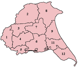
2. Buckrose
3. Harthill – Wilton Beacon Division
4. Harthill – Holme Beacon Division
5. Howdenshire
6. Harthill – Hunsley Beacon Division
|width="30"|
|valign="top"|
 |width="40"|
|valign="top"|
7. Harthill – Bainton Beacon Division
8. Dickering
9. Holderness – North Division
10. Kingston upon Hull
(county corporate
)
11. Holderness – Middle Division
12. Holderness – South Division
|width="30"|
|valign="top"|
|}
Non-metropolitan district
Non-metropolitan districts, or colloquially shire districts, are a type of local government district in England. As created, they are sub-divisions of non-metropolitan counties in a so-called "two-tier" arrangement...
with unitary authority
Unitary authority
A unitary authority is a type of local authority that has a single tier and is responsible for all local government functions within its area or performs additional functions which elsewhere in the relevant country are usually performed by national government or a higher level of sub-national...
status, and is a ceremonial county
Ceremonial counties of England
The ceremonial counties are areas of England to which are appointed a Lord Lieutenant, and are defined by the government as counties and areas for the purposes of the Lieutenancies Act 1997 with reference to the metropolitan and non-metropolitan counties of England and Lieutenancies Act 1997...
of England. It is named after the historic
Historic counties of England
The historic counties of England are subdivisions of England established for administration by the Normans and in most cases based on earlier Anglo-Saxon kingdoms and shires...
East Riding of Yorkshire
Yorkshire
Yorkshire is a historic county of northern England and the largest in the United Kingdom. Because of its great size in comparison to other English counties, functions have been increasingly undertaken over time by its subdivisions, which have also been subject to periodic reform...
which was one of three ridings alongside the North Riding
North Riding of Yorkshire
The North Riding of Yorkshire was one of the three historic subdivisions of the English county of Yorkshire, alongside the East and West Ridings. From the Restoration it was used as a Lieutenancy area. The three ridings were treated as three counties for many purposes, such as having separate...
and West Riding
West Riding of Yorkshire
The West Riding of Yorkshire is one of the three historic subdivisions of Yorkshire, England. From 1889 to 1974 the administrative county, County of York, West Riding , was based closely on the historic boundaries...
, which were constituent parts a Yorkshire ceremonial and administrative county
Administrative counties of England
Administrative counties were a level of subnational division of England used for the purposes of local government from 1889 to 1974. They were created by the Local Government Act 1888 as the areas for which county councils were elected. Some large counties were divided into several administrative...
until 1974. From 1974 to 1996 the area of the modern East Riding of Yorkshire constituted the northern part of Humberside
Humberside
Humberside was a non-metropolitan and ceremonial county in Northern England from 1 April 1974 until 1 April 1996. It was composed of land from either side of the Humber Estuary, created from portions of the East and West ridings of Yorkshire and parts of Lindsey, Lincolnshire...
.
Location
As a ceremonial county, the East Riding of Yorkshire borders North YorkshireNorth Yorkshire
North Yorkshire is a non-metropolitan or shire county located in the Yorkshire and the Humber region of England, and a ceremonial county primarily in that region but partly in North East England. Created in 1974 by the Local Government Act 1972 it covers an area of , making it the largest...
, South Yorkshire
South Yorkshire
South Yorkshire is a metropolitan county in the Yorkshire and the Humber region of England. It has a population of 1.29 million. It consists of four metropolitan boroughs: Barnsley, Doncaster, Rotherham, and City of Sheffield...
and Lincolnshire
Lincolnshire
Lincolnshire is a county in the east of England. It borders Norfolk to the south east, Cambridgeshire to the south, Rutland to the south west, Leicestershire and Nottinghamshire to the west, South Yorkshire to the north west, and the East Riding of Yorkshire to the north. It also borders...
, and includes the city of Kingston upon Hull
Kingston upon Hull
Kingston upon Hull , usually referred to as Hull, is a city and unitary authority area in the ceremonial county of the East Riding of Yorkshire, England. It stands on the River Hull at its junction with the Humber estuary, 25 miles inland from the North Sea. Hull has a resident population of...
, which is a separate unitary authority. As a district it borders North East Lincolnshire
North East Lincolnshire
North East Lincolnshire is a unitary authority in the Yorkshire and the Humber region of England, bordering the unitary authority of North Lincolnshire and the administrative county of Lincolnshire...
(over the Humber
Humber
The Humber is a large tidal estuary on the east coast of Northern England. It is formed at Trent Falls, Faxfleet, by the confluence of the tidal River Ouse and the tidal River Trent. From here to the North Sea, it forms part of the boundary between the East Riding of Yorkshire on the north bank...
estuary), North Lincolnshire
North Lincolnshire
North Lincolnshire is a unitary authority area in the region of Yorkshire and the Humber in England. For ceremonial purposes it is part of Lincolnshire....
(over the Humber and on land), Hull
Kingston upon Hull
Kingston upon Hull , usually referred to as Hull, is a city and unitary authority area in the ceremonial county of the East Riding of Yorkshire, England. It stands on the River Hull at its junction with the Humber estuary, 25 miles inland from the North Sea. Hull has a resident population of...
, Doncaster
Metropolitan Borough of Doncaster
The Metropolitan Borough of Doncaster is a metropolitan borough of South Yorkshire in Yorkshire and the Humber Region of England.In addition to the town of Doncaster, the borough covers Mexborough, Conisbrough, Thorne and Finningley....
, Selby
Selby (district)
Selby is a local government district of North Yorkshire, England. The local authority, Selby District Council, is based in the town of Selby and provides services to an area which includes Tadcaster and a host of villages....
, York
York
York is a walled city, situated at the confluence of the Rivers Ouse and Foss in North Yorkshire, England. The city has a rich heritage and has provided the backdrop to major political events throughout much of its two millennia of existence...
, Ryedale
Ryedale
Ryedale is a non-metropolitan district of the shire county of North Yorkshire in England. Settlements include Helmsley, Kirkbymoorside, Malton, Norton-on-Derwent, Pickering, and Terrington.-Derivation of name:...
and Scarborough
Scarborough (borough)
Scarborough is a non-metropolitan district and borough of North Yorkshire, England. In addition to the town of Scarborough, it covers a large stretch of the coast of Yorkshire, including Whitby and Filey....
.
Administrative history
The East Riding originated in antiquity. Unlike most counties in Great Britain, which were divided anciently into hundreds, Yorkshire was divided first into three ridings and then into numerous wapentakes within each riding. It should be noted that the ancient wapentake system is not used in the modern day, though it is an important part of Yorkshire's cultural heritage. Within the East Riding of Yorkshire there were seven wapentakes (including Hull), two of these were further sub-divided into divisions, thus;2. Buckrose
Buckrose (wapentake)
Buckrose was a wapentake of the historic East Riding of Yorkshire, England consisting of the north-west part of the county; its territory is now partly in the modern East Riding and partly in North Yorkshire...
3. Harthill – Wilton Beacon Division
Harthill (wapentake)
Harthill was a wapentake of the historic East Riding of Yorkshire, England consisting of the central part of the county. Established in medieval times, it ceased to have much significance in the 19th century when the wapentakes were superseded by other administrative divisions for most local...
4. Harthill – Holme Beacon Division
Harthill (wapentake)
Harthill was a wapentake of the historic East Riding of Yorkshire, England consisting of the central part of the county. Established in medieval times, it ceased to have much significance in the 19th century when the wapentakes were superseded by other administrative divisions for most local...
5. Howdenshire
Howdenshire
Howdenshire was a wapentake and a liberty of England, lying around the town of Howden in the East Riding of Yorkshire.In the Saxon period, the district was under the control of Peterborough's monastery, but it was confiscated by Edward the Confessor, and then given to the Bishop of Durham by...
6. Harthill – Hunsley Beacon Division
Harthill (wapentake)
Harthill was a wapentake of the historic East Riding of Yorkshire, England consisting of the central part of the county. Established in medieval times, it ceased to have much significance in the 19th century when the wapentakes were superseded by other administrative divisions for most local...
|width="30"|
|valign="top"|
|valign="top"|
7. Harthill – Bainton Beacon Division
Harthill (wapentake)
Harthill was a wapentake of the historic East Riding of Yorkshire, England consisting of the central part of the county. Established in medieval times, it ceased to have much significance in the 19th century when the wapentakes were superseded by other administrative divisions for most local...
8. Dickering
Dickering (wapentake)
Dickering was a wapentake of the historic East Riding of Yorkshire, England consisting of the north-east part of the county, including the towns of Bridlington and Filey; its territory is now partly in the modern East Riding and partly in North Yorkshire...
9. Holderness – North Division
Holderness (wapentake)
Holderness was a wapentake of the historic East Riding of Yorkshire, England consisting of the south-easterly part of the county. Established in medieval times, it ceased to have much significance in the 19th century when the wapentakes were superseded by other administrative divisions for...
10. Kingston upon Hull
Kingston upon Hull
Kingston upon Hull , usually referred to as Hull, is a city and unitary authority area in the ceremonial county of the East Riding of Yorkshire, England. It stands on the River Hull at its junction with the Humber estuary, 25 miles inland from the North Sea. Hull has a resident population of...
(county corporate
County corporate
A county corporate or corporate county was a type of subnational division used for local government in England, Ireland and Wales.Counties corporate were created during the Middle Ages, and were effectively small self-governing counties...
)
11. Holderness – Middle Division
Holderness (wapentake)
Holderness was a wapentake of the historic East Riding of Yorkshire, England consisting of the south-easterly part of the county. Established in medieval times, it ceased to have much significance in the 19th century when the wapentakes were superseded by other administrative divisions for...
12. Holderness – South Division
Holderness (wapentake)
Holderness was a wapentake of the historic East Riding of Yorkshire, England consisting of the south-easterly part of the county. Established in medieval times, it ceased to have much significance in the 19th century when the wapentakes were superseded by other administrative divisions for...
|width="30"|
|valign="top"|
|}
The separate Lieutenancy for the riding was established after the Restoration
English Restoration
The Restoration of the English monarchy began in 1660 when the English, Scottish and Irish monarchies were all restored under Charles II after the Interregnum that followed the Wars of the Three Kingdoms...
, and the ridings each had separate Quarter Sessions
Quarter Sessions
The Courts of Quarter Sessions or Quarter Sessions were local courts traditionally held at four set times each year in the United Kingdom and other countries in the former British Empire...
.
For statistical purposes in the 19th century an East Riding of Yorkshire registration county
Registration county
A registration county was, in Great Britain and Ireland, a statistical unit used for the registration of births, deaths and marriages and for the output of census information. In Scotland registration counties are used for land registration purposes....
was designated, consisting of the entirety of the poor law union
Poor Law Union
A Poor Law Union was a unit used for local government in the United Kingdom from the 19th century. The administration of the Poor Law was the responsibility of parishes, which varied wildly in their size, populations, financial resources, rateable values and requirements...
s of Beverley, Bridlington, Driffield, Howden, Hull, Patrington, Pocklington, Sculcoates, Skirlaugh and York, thus excluding parts of the historic riding around Norton
Norton-on-Derwent
Norton-on-Derwent, commonly referred to as 'Norton', is a town and civil parish in the Ryedale district of North Yorkshire, England. Norton borders the market town of Malton, and is divided by the River Derwent...
and Sherburn
Sherburn, North Yorkshire
Sherburn is a village and civil parish in the Ryedale district of North Yorkshire, England. According to the 2001 UK census, Sherburn parish had a population of 786.The parish council is .St...
(which are also excluded from the modern district), but also including the city of York and environs (more usually associated with the West Riding). These poor law unions formed the basis of rural sanitary districts in 1875.
A county council for the East Riding of Yorkshire was set up in 1889, covering an administrative county
Administrative county
An administrative county was an administrative division in England and Wales and Ireland used for the purposes of local government. They are now abolished, although in Northern Ireland their former areas are used as the basis for lieutenancy....
which did not cover the county borough
County borough
County borough is a term introduced in 1889 in the United Kingdom of Great Britain and Ireland , to refer to a borough or a city independent of county council control. They were abolished by the Local Government Act 1972 in England and Wales, but continue in use for lieutenancy and shrievalty in...
of Hull, but otherwise had the same boundaries as the historic riding. Apart from Hull the East Riding contained two municipal borough
Municipal borough
Municipal boroughs were a type of local government district which existed in England and Wales between 1835 and 1974, in Northern Ireland from 1840 to 1973 and in the Republic of Ireland from 1840 to 2002...
s, Beverley
Beverley
Beverley is a market town, civil parish and the county town of the East Riding of Yorkshire, England, located between the River Hull and the Westwood. The town is noted for Beverley Minster and architecturally-significant religious buildings along New Walk and other areas, as well as the Beverley...
and Hedon
Hedon
Hedon is a small town and civil parish in Holderness in the East Riding of Yorkshire, England. It is situated approximately east of Hull city centre. It lies to the north of the A1033 road at the crossroads of the B1240 and B1362 roads....
.
Under the Local Government Act 1894
Local Government Act 1894
The Local Government Act 1894 was an Act of the Parliament of the United Kingdom that reformed local government in England and Wales outside the County of London. The Act followed the reforms carried out at county level under the Local Government Act 1888...
the rest of the administrative county was divided into rural district
Rural district
Rural districts were a type of local government area – now superseded – established at the end of the 19th century in England, Wales, and Ireland for the administration of predominantly rural areas at a level lower than that of the administrative counties.-England and Wales:In England...
s and urban district
Urban district
In the England, Wales and Ireland, an urban district was a type of local government district that covered an urbanised area. Urban districts had an elected Urban District Council , which shared local government responsibilities with a county council....
s. The rural districts were based on the rural sanitary districts, with Beverley Rural District
Beverley Rural District
Beverley was a rural district in the East Riding of Yorkshire, England from 1894 to 1974.The district surrounded but did not include Beverley, which formed a municipal borough.The district was created by the Local Government Act 1894...
, Bridlington Rural District
Bridlington Rural District
Bridlington was a rural district in the East Riding of Yorkshire in England from 1894 to 1974. It covered a coastal area, and surrounded the municipal borough of Bridlington on its land borders. The district covered Flamborough and Flamborough Head....
, Driffield Rural District
Driffield Rural District
Driffield was a rural district in the East Riding of Yorkshire in England from 1894 to 1974. It surrounded the municipal borough of Driffield....
, Howden Rural District
Howden Rural District
Howden was a rural district in the East Riding of Yorkshire, England from 1894 to 1974.It was formed under the Local Government Act 1894 as a successor to the Howden rural sanitary district. It lost a few parishes to the newly created Derwent Rural District and parts to Beverley Rural District in...
, Patrington Rural District
Patrington Rural District
Patrington was a rural district in the East Riding of Yorkshire, England from 1894 to 1935.The district formed the south-eastern part of the county stretching from Hedon to Spurn.The district was created by the Local Government Act 1894....
, Pocklington Rural District
Pocklington Rural District
Pocklington was a rural district in the East Riding of Yorkshire, England from 1894 to 1974.The district surrounded but did not originally include Pocklington, which formed a separate urban district.The district was created by the Local Government Act 1894...
, Riccal Rural District
Riccal Rural District
Riccal was a rural district in the East Riding of Yorkshire, England from 1894 to 1935.It was formed in 1894 from that part of the Selby rural sanitary district which was in the East Riding ....
, Sculcoates Rural District
Sculcoates Rural District
Sculcoates was a rural district in the East Riding of Yorkshire, England from 1894 to 1935.The district formed three separate areas around Kingston upon Hull municipal borough.The district was created by the Local Government Act 1894....
and Skirlaugh Rural District
Skirlaugh Rural District
Skirlaugh was a rural district in the East Riding of Yorkshire, England from 1894 to 1935.The district formed an area around the Hornsea urban district.The district was created by the Local Government Act 1894....
being formed as-is.
Several other rural districts were formed by divisions of rural sanitary districts to conform to the administrative county borders : Sherburn Rural District
Sherburn Rural District
Sherburn was a rural district in the East Riding of Yorkshire from 1894 to 1935. It was formed under the Local Government Act 1894 from that part of the Scarborough rural sanitary district which was in the East Riding .It was abolished in 1935 by a County Review Order made under the Local...
and Norton Rural District came from Scarborough and Malton RSDs respectively (otherwise in North Riding); Riccal Rural District
Riccal Rural District
Riccal was a rural district in the East Riding of Yorkshire, England from 1894 to 1935.It was formed in 1894 from that part of the Selby rural sanitary district which was in the East Riding ....
from Selby RSD (otherwise in the West Riding); and Escrick Rural District
Escrick Rural District
Escrick was a rural district in the East Riding of Yorkshire from 1894 to 1935.It was formed under the Local Government Act 1894 from the part of the York Rural Sanitary District which was in the East Riding....
which was previously part of York RSD
York Rural Sanitary District
York was a rural sanitary district in Yorkshire, England until 1894. It was based on the York poor law union , and included parishes in the West Riding, the North Riding and the East Riding, forming a ring around the city.It was abolished in 1894 under the Local Government Act 1894, and split to...
(which covered all three ridings). Urban districts were Cottingham, Great Driffield, Hessle
Hessle
Hessle is a town and civil parish in the East Riding of Yorkshire, England, situated west of Kingston upon Hull city centre. Geographically it is part of a larger urban area which consists of the city of Kingston upon Hull, the town of Hessle and a number of other villages but is not part of the...
(from 1899), Hornsea
Hornsea
Hornsea is a small seaside resort, town and civil parish in the East Riding of Yorkshire, England at the eastern end of the Trans Pennine Trail.-Overview:According to the 2001 UK Census, Hornsea parish had a population of 8,243....
, Norton
Norton-on-Derwent
Norton-on-Derwent, commonly referred to as 'Norton', is a town and civil parish in the Ryedale district of North Yorkshire, England. Norton borders the market town of Malton, and is divided by the River Derwent...
, Pocklington
Pocklington
Pocklington is a small market town and civil parish situated at the foot of the Yorkshire Wolds in the East Riding of Yorkshire, England, approximately east of York....
and Withernsea
Withernsea
Withernsea is a seaside resort town and civil parish in the East Riding of Yorkshire, England, and forms the focal point for a wider community of small villages in Holderness. Its most famous landmark is the white inland lighthouse, rising around above Hull Road...
.
The East Riding's only large town is Hull, a major port. Hull's population of which rose rapidly in the late 19th century : quadrupling from about 60,000 in 1851 to 240,000 in 1901. Other towns in the riding did not have similar growth and remain small: Bridlington's permanent population remained largely static in the same period, increasing from 6,000 to around 7,000. By 1971 the riding had a population of slightly over 500,000. In comparison, the West Riding
West Riding of Yorkshire
The West Riding of Yorkshire is one of the three historic subdivisions of Yorkshire, England. From 1889 to 1974 the administrative county, County of York, West Riding , was based closely on the historic boundaries...
(including county boroughs) saw extensive urbanisation and the formation of several conurbations, and had a population of nearly 4,000,000 in 1971, and the North Riding
North Riding of Yorkshire
The North Riding of Yorkshire was one of the three historic subdivisions of the English county of Yorkshire, alongside the East and West Ridings. From the Restoration it was used as a Lieutenancy area. The three ridings were treated as three counties for many purposes, such as having separate...
a population of about 700,000. Beverley was once a town of some importance, with St. John's College and Beverley Minster
Beverley Minster
Beverley Minster, in Beverley, East Riding of Yorkshire is a parish church in the Church of England. It is said to be the largest parish church in the UK....
. The college was suppressed along with the monastery in the 16th century (see Dissolution of the Monasteries
Dissolution of the Monasteries
The Dissolution of the Monasteries, sometimes referred to as the Suppression of the Monasteries, was the set of administrative and legal processes between 1536 and 1541 by which Henry VIII disbanded monasteries, priories, convents and friaries in England, Wales and Ireland; appropriated their...
) and the town entered a decline in relative importance, although gaining a charter of incorporation in 1573, having previously been under the Archbishop of York
Archbishop of York
The Archbishop of York is a high-ranking cleric in the Church of England, second only to the Archbishop of Canterbury. He is the diocesan bishop of the Diocese of York and metropolitan of the Province of York, which covers the northern portion of England as well as the Isle of Man...
. Beverley benefited somewhat from the proximity of Hull during the Industrial Revolution
Industrial Revolution
The Industrial Revolution was a period from the 18th to the 19th century where major changes in agriculture, manufacturing, mining, transportation, and technology had a profound effect on the social, economic and cultural conditions of the times...
, and became the county town for the East Riding administrative county in 1892.
Bridlington obtained municipal borough
Municipal borough
Municipal boroughs were a type of local government district which existed in England and Wales between 1835 and 1974, in Northern Ireland from 1840 to 1973 and in the Republic of Ireland from 1840 to 2002...
status in 1899, having become a resort town
Resort town
A resort town, sometimes called a resort city or resort destination, is a town or area where tourism or vacationing is a primary component of the local culture and economy...
(as had Hornsea
Hornsea
Hornsea is a small seaside resort, town and civil parish in the East Riding of Yorkshire, England at the eastern end of the Trans Pennine Trail.-Overview:According to the 2001 UK Census, Hornsea parish had a population of 8,243....
and Withernsea
Withernsea
Withernsea is a seaside resort town and civil parish in the East Riding of Yorkshire, England, and forms the focal point for a wider community of small villages in Holderness. Its most famous landmark is the white inland lighthouse, rising around above Hull Road...
), although not matching the population growth of Scarborough further up the coast in the North Riding.
The county districts underwent a major reorganisation in 1935 :
- Derwent Rural DistrictDerwent Rural DistrictDerwent was a rural district in the East Riding of Yorkshire from 1935 to 1974.It was created under a County Review Order in 1935, from most of the Escrick Rural District and the Riccal Rural District, and part of the Howden Rural District....
formed from most of Escrick RD, Riccal RD and part of Howden RD (which continued in existence) - Holderness Rural DistrictHolderness Rural DistrictHolderness was a rural district in the East Riding of Yorkshire from 1935 to 1974, covering the Holderness area.It was created by a County Review Order made under the Local Government Act 1929 by the merger of Patrington Rural District, most of Skirlaugh Rural District and part of Sculcoates Rural...
formed from Patrington RD and Skirlaugh RD - Sherburn RD abolished, split between Bridlington RD, Norton RD and part to Filey UD
- Sculcoates RD abolished, mostly to Beverley RD
- Great Driffield urban district made smaller and renamed Driffield, the rural part going to NaffertonNaffertonNafferton is a village and civil parish in the East Riding of Yorkshire, England. It is situated approximately north east of Driffield town centre and lies just south of the A614 road....
parish in Driffield Rural DistrictDriffield Rural DistrictDriffield was a rural district in the East Riding of Yorkshire in England from 1894 to 1974. It surrounded the municipal borough of Driffield.... - an urban districtUrban districtIn the England, Wales and Ireland, an urban district was a type of local government district that covered an urbanised area. Urban districts had an elected Urban District Council , which shared local government responsibilities with a county council....
of HaltempriceHaltempricethumb|right|200px|Obsolete Arms of the Former Haltemprice Urban District CouncilHaltemprice is an area in the East Riding of Yorkshire, England, directly to the west of Hull. It comprises the villages, Anlaby, Cottingham, Hessle, Kirk Ella, Skidby, West Ella and Willerby...
formed to cover the urbanised area west of Hull, from Cottingham and Hessle urban districts, and parts of Sculcoates Rural DistrictSculcoates Rural DistrictSculcoates was a rural district in the East Riding of Yorkshire, England from 1894 to 1935.The district formed three separate areas around Kingston upon Hull municipal borough.The district was created by the Local Government Act 1894....
(including HaltempriceHaltempricethumb|right|200px|Obsolete Arms of the Former Haltemprice Urban District CouncilHaltemprice is an area in the East Riding of Yorkshire, England, directly to the west of Hull. It comprises the villages, Anlaby, Cottingham, Hessle, Kirk Ella, Skidby, West Ella and Willerby...
, West EllaWest EllaWest Ella is a village in the East Riding of Yorkshire, England and is located approximately west of the city of Kingston upon Hull. It is situated on the east side of the A164 road. On the other side of the A164 road is Swanland...
and parts of other parishes) - Pocklington urban district abolished and added to Pocklington RD
Both the administrative county and the historic Lieutenancy were abolished under the Local Government Act 1972
Local Government Act 1972
The Local Government Act 1972 is an Act of Parliament in the United Kingdom that reformed local government in England and Wales on 1 April 1974....
, on 1 April 1974, with most of the riding going to form the northern part of Humberside
Humberside
Humberside was a non-metropolitan and ceremonial county in Northern England from 1 April 1974 until 1 April 1996. It was composed of land from either side of the Humber Estuary, created from portions of the East and West ridings of Yorkshire and parts of Lindsey, Lincolnshire...
. Some parts became part of North Yorkshire
North Yorkshire
North Yorkshire is a non-metropolitan or shire county located in the Yorkshire and the Humber region of England, and a ceremonial county primarily in that region but partly in North East England. Created in 1974 by the Local Government Act 1972 it covers an area of , making it the largest...
, with the borough of Scarborough
Scarborough (borough)
Scarborough is a non-metropolitan district and borough of North Yorkshire, England. In addition to the town of Scarborough, it covers a large stretch of the coast of Yorkshire, including Whitby and Filey....
taking in Filey
Filey
Filey is a small town and civil parish in North Yorkshire, England. It forms part of the borough of Scarborough and is located between Scarborough and Bridlington on the North Sea coast. Although it started out as a fishing village, it has a large beach and is a popular tourist resort...
UD and part of the Bridlington Rural District
Bridlington Rural District
Bridlington was a rural district in the East Riding of Yorkshire in England from 1894 to 1974. It covered a coastal area, and surrounded the municipal borough of Bridlington on its land borders. The district covered Flamborough and Flamborough Head....
, the district of Ryedale
Ryedale
Ryedale is a non-metropolitan district of the shire county of North Yorkshire in England. Settlements include Helmsley, Kirkbymoorside, Malton, Norton-on-Derwent, Pickering, and Terrington.-Derivation of name:...
taking in Norton
Norton-on-Derwent
Norton-on-Derwent, commonly referred to as 'Norton', is a town and civil parish in the Ryedale district of North Yorkshire, England. Norton borders the market town of Malton, and is divided by the River Derwent...
and the former Norton Rural District, and the district of Selby
Selby (district)
Selby is a local government district of North Yorkshire, England. The local authority, Selby District Council, is based in the town of Selby and provides services to an area which includes Tadcaster and a host of villages....
taking in the former Derwent Rural District
Derwent Rural District
Derwent was a rural district in the East Riding of Yorkshire from 1935 to 1974.It was created under a County Review Order in 1935, from most of the Escrick Rural District and the Riccal Rural District, and part of the Howden Rural District....
. Humberside also included northern Lincolnshire, and Goole
Goole
Goole is a town, civil parish and port located approximately inland on the confluence of the rivers Don and Ouse in the East Riding of Yorkshire, England...
and the former Goole Rural District
Goole Rural District
Goole was a rural district in the West Riding of Yorkshire, England from 1894 to 1974.It was created under the Local Government Act 1894, based on most of the Goole rural sanitary district . The town of Goole itself formed a separate urban district...
, which are in the historic West Riding
West Riding of Yorkshire
The West Riding of Yorkshire is one of the three historic subdivisions of Yorkshire, England. From 1889 to 1974 the administrative county, County of York, West Riding , was based closely on the historic boundaries...
.
The creation of a cross-Humber authority was unpopular, despite the promise of the Humber Bridge
Humber Bridge
The Humber Bridge, near Kingston upon Hull, England, is a 2,220 m single-span suspension bridge, which opened to traffic on 24 June 1981. It is the fifth-largest of its type in the world...
(which ultimately opened in 1981), and identification with Yorkshire and the East Riding remained strong (for example, North Wolds District Council change its name to East Yorkshire District Council in the early 1980s, with Beverley also taking the name 'East Yorkshire Borough of Beverley'). This culminated with the local government review
1990s UK local government reform
The structure of local government in the United Kingdom underwent large changes in the 1990s. The system of two-tier local government introduced in the 1970s by the Local Government Act 1972 and the Local Government Act 1973 was abolished in Scotland and Wales on April 1, 1996, and replaced with...
in the 1990s, which saw Humberside abolished and the northern part form two unitary authorities
Unitary authority
A unitary authority is a type of local authority that has a single tier and is responsible for all local government functions within its area or performs additional functions which elsewhere in the relevant country are usually performed by national government or a higher level of sub-national...
.
The East Riding district was formed on 1 April 1996 from the former districts of East Yorkshire
East Yorkshire (district)
The Borough of East Yorkshire was one of nine local government districts of the county of Humberside, England from April 1, 1974 to April 1, 1996....
, Beverley
Beverley (borough)
Beverley was a local government district and borough of Humberside, England, from 1974 to 1996.It was formed on 1 April 1974 by the merger of the previous borough of Beverley, with Beverley Rural District and Haltemprice Urban District...
and Holderness
Holderness (borough)
Holderness was a local government district and borough in northern England, named for the Holderness peninsula.It was formed on 1 April 1974 along with the non-metropolitan county of Humberside in which it was situated...
, along with the northern part of the Boothferry district, including the Goole area which forms part of the historic West Riding (attaching it to the districts of Selby
Selby (district)
Selby is a local government district of North Yorkshire, England. The local authority, Selby District Council, is based in the town of Selby and provides services to an area which includes Tadcaster and a host of villages....
or Doncaster
Metropolitan Borough of Doncaster
The Metropolitan Borough of Doncaster is a metropolitan borough of South Yorkshire in Yorkshire and the Humber Region of England.In addition to the town of Doncaster, the borough covers Mexborough, Conisbrough, Thorne and Finningley....
were proposed but rejected). The ceremonial county, the area in which the Lord Lieutenant of the East Riding of Yorkshire
Lord Lieutenant of the East Riding of Yorkshire
This is a list of people who have served as Lord Lieutenant for the East Riding of Yorkshire. The office was established after the English Restoration in 1660, when a Lord Lieutenant was appointed for each Riding of Yorkshire. Since 1721, all Lord Lieutenants have also been Custos Rotulorum of the...
represents the Crown
The Crown
The Crown is a corporation sole that in the Commonwealth realms and any provincial or state sub-divisions thereof represents the legal embodiment of governance, whether executive, legislative, or judicial...
, was re-established the same day, covering Hull as well as the district.
Archaeology
The East Riding has two quite distinctive and contrasting archaeological areas, the Yorkshire WoldsYorkshire Wolds
The Yorkshire Wolds are low hills in the counties of East Riding of Yorkshire and North Yorkshire in northeastern England. The name also applies to the district in which the hills lie....
and the Humber Wetlands. The Yorkshire Wolds form an upland arc of chalk hills stretching from Flamborough head on the coast to the Humber Estuary at its southern end. The Humber Wetlands consist of all the land in the Humber basin that lies below 10 metres above sea level which encompasses a large part of Holderness and the valleys of the Rivers Hull and Derwent and the lower part of the River Ouse valley.
The Arctic conditions associated with the last Ice Age
Ice age
An ice age or, more precisely, glacial age, is a generic geological period of long-term reduction in the temperature of the Earth's surface and atmosphere, resulting in the presence or expansion of continental ice sheets, polar ice sheets and alpine glaciers...
started to improve and the climate gradually became warmer about 10,000 BC. This warming-up process suffered several temporary setbacks as short, cool spells occurred which disrupted the overall momentum. By about 9,000 BC the vegetation had changed from tundra to a closed woodland, of pine and birch.
Evidence from Gransmoor, to the east of Driffield, in Holderness indicates that Late Palaeolithic people were present in East Yorkshire during the climatic transition. In 1992, a small barbed antler harpoon point was found lodged in a birch log. This find has been dated to around 9,500 BC.
Between 8,300 and 4,000 BC, Mesolithic
Mesolithic
The Mesolithic is an archaeological concept used to refer to certain groups of archaeological cultures defined as falling between the Paleolithic and the Neolithic....
communities occupied the area. In the GreatWold Valley, at Willow Garth, to the west of Boynton
Boynton, East Riding of Yorkshire
Boynton is a village and civil parish in the East Riding of Yorkshire, England. It is situated approximately west of the town of Bridlington and lies on the B1253 road.According to the 2001 UK census, Boynton parish had a population of 161....
, pollen samples of Mesolithic date, indicate that the forest cover in this area was being altered by man, and that open grasslands were being made in order to create grazing areas to which animals would be attracted thus making hunting easier.
In the Yorkshire Wolds there are thousands of Iron Age square barrows and hundreds of farmsteads and settlements, droveways, tracks and field systems. There is a profusion of Neolithic, Bronze Age, Iron Age and Romano-British sites extending across the entire Wolds area. Some Mesolithic
Mesolithic
The Mesolithic is an archaeological concept used to refer to certain groups of archaeological cultures defined as falling between the Paleolithic and the Neolithic....
sites are known on the chalklands of the Yorkshire Wolds, at Craike Hill (Eastburn Warren), Garton Slack, Huggate Dykes, Huggate Wold, and Octon Wold. The Yorkshire Wolds has a wide range of favourable natural resources and so became a major focus for human settlement during the Neolithic
Neolithic
The Neolithic Age, Era, or Period, or New Stone Age, was a period in the development of human technology, beginning about 9500 BC in some parts of the Middle East, and later in other parts of the world. It is traditionally considered as the last part of the Stone Age...
period. Two of the most recently excavated earthen long barrows in the region are to be found at Fordon
Fordon, East Riding of Yorkshire
Fordon is a hamlet in the East Riding of Yorkshire, England. It is situated approximately south of Scarborough and north west of Bridlington.It forms part of the civil parish of Wold Newton....
, on Willerby Wold, and at Kilham
Kilham, East Riding of Yorkshire
Kilham is a village and civil parish in the East Riding of Yorkshire, England. It is situated about north-east of Driffield town centre.According to the 2001 UK census, Kilham parish had a population of 1,010....
, both of which have provided radiocarbon dates of around 3,700 BC. An extensive Neolithic ritual complex, the principal elements of which are four large cursus
Cursus
thumb|right|250px|[[Stonehenge Cursus]], Wiltshirethumb|right|250px|[[Dorset Cursus]] terminal on Thickthorn Down, DorsetCursus was a name given by early British archaeologists such as William Stukeley to the large parallel lengths of banks with external ditches which they thought were early Roman...
monuments and a henge
Henge
There are three related types of Neolithic earthwork which are all sometimes loosely called henges. The essential characteristic of all three types is that they feature a ring bank and ditch but with the ditch inside the bank rather than outside...
, is situated near the eastern end of the Great Wold Valley
Great Wold Valley
The Great Wold Valley is the largest and broadest of the valleys cutting into the Yorkshire Wolds. It carries the Gypsey Race, an intermittent stream, which once ran from Wharram-le-Street eastwards along and through the northern Yorkshire Wolds to reach the sea at Bridlington.It is known that the...
. More than 1,400 Bronze Age round barrows, are known to exist on the Yorkshire Wolds, occurring either in isolation or, more usually, grouped together to form cemeteries. In the Iron Age
Iron Age
The Iron Age is the archaeological period generally occurring after the Bronze Age, marked by the prevalent use of iron. The early period of the age is characterized by the widespread use of iron or steel. The adoption of such material coincided with other changes in society, including differing...
the distinctive local tradition known as the Arras Culture
Arras Culture
The Arras culture is an archaeological culture of the Middle Iron Age in East Yorkshire It takes its name from the cemetery site of Arras near Market Weighton in the East Riding of Yorkshire, which was discovered in the 19th century...
emerged and was named after the type-site, found near Market Weighton
Market Weighton
Market Weighton is a small town and civil parish in the East Riding of Yorkshire, England. It is one of the main market towns in the East Yorkshire Wolds and lies midway between Hull and York, about from either one...
, and excavated in 1815–17. Romano British villa sites are known on the Wolds at Rudston, Harpham, Brantingham, Welton, and Wharram-le-Street. Anglo-Saxon cemeteries are known from East Yorkshire.
The Humber Wetlands Project which took place between 1992 and 2001 identified numerous prehistoric wetland sites in Holderness, the Hull Valley, the Humberhead Levels and the Vale of York.
A boat found at North Ferriby
North Ferriby
North Ferriby is a village and civil parish in the Haltemprice area of the East Riding of Yorkshire, England.-Geography:It is situated on the north bank of the Humber Estuary, approximately to the west of Hull city centre. To the north, atop a hill, lies Swanland via the B1231. South Ferriby is...
, near Kingston upon Hull, has been dated as 2030 BC, which makes it the oldest of its kind in western Europe. New scientific research carried out on the remains shows it is at least 4,000 years old. The boat was one of three discovered by amateur archaeologist Ted Wright on the banks of the Humber. Historians knew that the boats were old, but only now do they know how old. New scientific techniques suggest the boat Mr Wright found in 1963 is 500 years older than everyone thought. That means it date backs more than 4,000 years to the early Bronze Age. The Ferriby site was an ideal point of departure for east/west travel along the Humber or as a crossing-point to the south bank. The Ferriby Boats
Ferriby Boats
The Ferriby Boats are three Bronze Age sewn plank-built boats, parts of which were discovered at North Ferriby in the East Riding of the English county of Yorkshire...
were a means by which ideas, such as the decorative design of pottery, and goods such as Baltic amber and metals could arrive on the Humber shore. It has also been suggested that it may have been used to carry stones to Stonehenge.
Norman period
The Battle of Stamford BridgeBattle of Stamford Bridge
The Battle of Stamford Bridge took place at the village of Stamford Bridge, East Riding of Yorkshire in England on 25 September 1066, between an English army under King Harold Godwinson and an invading Norwegian force led by King Harald Hardrada of Norway and the English king's brother Tostig...
took place at the village of Stamford Bridge, East Riding of Yorkshire
Stamford Bridge, East Riding of Yorkshire
Stamford Bridge is a village and civil parish on the River Derwent in the East Riding of Yorkshire, England, approximately east of York.-Location and history:The village sits astride an ancient ford on the River Derwent....
on 25 September 1066. In the battle the majority of the invading Norwegian forces were killed by the forces of King Harold Godwinson
Harold Godwinson
Harold Godwinson was the last Anglo-Saxon King of England.It could be argued that Edgar the Atheling, who was proclaimed as king by the witan but never crowned, was really the last Anglo-Saxon king...
of England. It was the final fall of the Viking
Viking
The term Viking is customarily used to refer to the Norse explorers, warriors, merchants, and pirates who raided, traded, explored and settled in wide areas of Europe, Asia and the North Atlantic islands from the late 8th to the mid-11th century.These Norsemen used their famed longships to...
s in England. A fortnight
Fortnight
The fortnight is a unit of time equal to fourteen days, or two weeks. The word derives from the Old English fēowertyne niht, meaning "fourteen nights"....
after the battle, on 14 October 1066, after having marched his forces to the south coast of England, Harold was defeated and killed by Norman forces under William the Conqueror
William I of England
William I , also known as William the Conqueror , was the first Norman King of England from Christmas 1066 until his death. He was also Duke of Normandy from 3 July 1035 until his death, under the name William II...
at the Battle of Hastings
Battle of Hastings
The Battle of Hastings occurred on 14 October 1066 during the Norman conquest of England, between the Norman-French army of Duke William II of Normandy and the English army under King Harold II...
. This began the Norman Conquest of England.
In Holderness the extensive Lordship was granted by King William I of England to Drogo de la Beuvirere, a Flemish follower. Drogo built a castle at Skipsea before 1087 but he was disgraced and his estates were confiscated by the king. The area was then given to Odo, Count of Champagne, but was taken from him when he rebelled against King William II of England in 1095. It was returned to Odo's son Stephen of Aumale
Stephen of Aumale
Stephen of Aumale was Count of Aumale from 1082 to 1127.He was son of Eudes de Blois, Count of Troyes and Count of Meaux, and Adelaide of Normandy, countess of Aumale, and sister of William the Conqueror...
in 1102. Large estates in Holderness were held by the Bishop of Durham and the Archbishop of York
Archbishop of York
The Archbishop of York is a high-ranking cleric in the Church of England, second only to the Archbishop of Canterbury. He is the diocesan bishop of the Diocese of York and metropolitan of the Province of York, which covers the northern portion of England as well as the Isle of Man...
. Other large landowners in the area included the abbeys of Meaux
Meaux Abbey
Meaux Abbey was a Cistercian Abbey founded in 1151 by William le Gros, 1st Earl of Albemarle , Earl of York and 4th lord of Holderness, near Beverley in the East Riding of Yorkshire....
and Thornton
Thornton Abbey
Thornton Abbey was founded as a priory in 1139 by William le Gros, the Earl of Yorkshire, and raised to the status of Abbey in 1148. It was a house for Augustinian or black canons. These priests lived a communal life under the Rule of St Augustine but also undertook pastoral duties outside of the...
and the priories of Swine, Nunkeeling and Bridlington
Bridlington Priory
Priory Church of St. Mary, Bridlington, , commonly known as Bridlington Priory Church is a parish church in Bridlington, East Riding of Yorkshire, England, in the Diocese of York...
. These ecclesiastical estates were confiscated and became crown property when King Henry VIII of England
Henry VIII of England
Henry VIII was King of England from 21 April 1509 until his death. He was Lord, and later King, of Ireland, as well as continuing the nominal claim by the English monarchs to the Kingdom of France...
dissolved the monasteries in the 16th century. The Yorkshire Wolds is rich in medieval sites, and is particularly well-known for its deserted villages, like those at Wharram Percy and Cottam. Settlement on the Wolds during the medieval period was concentrated on the most suitable agricultural soils. The two major settlement zones are, the Great Wold Valley villages, such as Helperthorpe, Weaverthorpe, Butterwick, Foxholes, Burton Flemming and Rudston, and the east-facing slope of the Wolds including villages such as Carnaby, Haisthorpe, Thornholme, Burton Agnes, and Nafferton, all of which are sited so as to take advantage of a ration of both heavier and lighter agricultural soils.