
Stamford Bridge, East Riding of Yorkshire
Encyclopedia
Stamford Bridge is a village and civil parish on the River Derwent
in the East Riding of Yorkshire
, England
, approximately 7 miles (11.3 km) east of York
.
.
The Romans
established a fort here around 70 AD, around which later developed a large linear civilian settlement focused on a bridge one mile (1.6 km) south of the present town. Iter I of the Antonine Itinerary
lists "Derventio" as being seven Roman miles from Eboracum (York) which matches the distance from York. In relation to known discoveries under the town of Malton, antiquaries always assumed that Malton should be called Derventio. The remains at Stamford Bridge were not known to them, lying undiscovered under arable and pasture fields until quite recently. In consideration of this archaeological evidence, and in absence of any other possible contenders, Stamford Bridge should be considered to be Roman Derventio.
The Battle of Stamford Bridge
on 25 September 1066 marked the end of the Viking
era in Britain
.
The settlement was called Pons Belli by the Normans
, meaning battle bridge. Rents of freeholders and cottagers were recorded in 1368 and there was a common oven recorded the same year.
The A166 east-west road crossing the river at Stamford Bridge is one of the main roads from York to the East Riding and the coast. The road bridge in the village was closed on 5 March 2007, for just over 11 weeks, so that essential repairs could be carried out, in light of the enormous volume of traffic that uses it, exceptional for such an old bridge (dating from 1727). The bridge re-opened on 22 May.
In 1882 the population was 449; in the 2001 UK census
the parish population was 3,394.
The village suffered from record floods in November 2000 which seriously flooded 30 businesses and homes. Flood defences have now been installed, costing £3.7 million.
The history of Stamford Bridge is covered in British History Online:
Catton Kexby, Scoreby, and Stamford Bridge West, http://www.british-history.ac.uk/report.asp?compid=23020#s1 and
Catton High and Low Catton and Stamford Bridge East http://www.british-history.ac.uk/report.asp?compid=23019&strquery=http://www.british-history.ac.uk/report.asp?compid=23019&s
divides Stamford Bridge into two. It rises in the North Yorkshire Moors and flows south west rather than taking a direct route to the North Sea. It eventually joins the River Ouse north of the village of Long Drax, before flowing ultimately into the Humber Estuary.
During 4/5 March 1999, exceptional levels of rainfall were experienced in the Derwent catchment area, reaching 125 millimetres (4.9 in) inside a 24 hour period. The situation was worsened by melting snow which had earlier accumulated on the North York Moors.
The conditions deteriorated and by Sunday 7 March large areas of Stamford Bridge were under water and a final flooding depth of approximately 1.5 metres (4.9 ft) was recorded by Monday 8 March.
At the height of the flooding the River Derwent reach the peak of 5m above its normal level, the highest level ever recorded exceeding the previous highest in 1931 by 0.5 metres (19.7 in).
However, the following year a new record flood level was set. In October 2000 the Derwent again burst its banks and peaked slightly above the 1999 flood level.
Work started in Autumn 2003 to build new flood defences for Stamford Bridge and in Autumn 2004, work on the defences were finished.
The flood defences were breached, and much of the village square was under water, on the morning of 26 June 2007, in the wake of exceptional rainfall over the previous 24 hours.
The current mill was possibly expanded in 1847-50 when nearly £1,000 was spent on it. Subsequently there were two water wheels and seven pairs of grinding stones. The mill ceased operation in 1964 and was converted into a restaurant in 1967.
More recently the Cornmill was converted into twelve apartments but some of the original equipment remains in place today. The two-bed apartments http://www.art-from-the-start.co.uk/designportfolio_1.asp were built in 2005 by Everdale Homes and have interior design by local company Art from the Start.
The Cornmill remains the most visible landmark in Stamford Bridge.
In the medieval period a new bridge made of timber supported on three stone piers was erected. Records show that this was repaired in the 13th and 16th centuries. A map from 1724 shows this bridge to have been 70 metres upstream from the current bridge.
In the 18th century the weir and the by-pass canal and lock, known as the New Cut, were built and the medieval bridge was replaced with the current structure.
The present bridge was designed by William Etty
under an Act of 1725 and completed in 1727.
The bridge was strengthened in the 1960s and at the same time the adjacent pedestrian bridge was erected.
The bridge is a Grade II listed monument.
across the Derwent. It consists of red brick arches on either side of a single wider wrought-iron span that crosses the river. The last train ran across the viaduct on 27 November 1965. Now disused the condition of the viaduct deteriorated to the point that East Yorkshire Borough Council announced their intention to demolish it in 1991. The plans were ultimately shelved after bitter protests from rail campaigners. The viaduct has since been repaired and made safe and now forms part of a public cycle route.
This original building was modernised and extended in 1968 and because of the rapid development of the village a further extension was added in 1978. In April 1983 a new infants building, in Godwinsway, Stamford Bridge, was added to the school. Built for 120 infant children it makes the school a split site establishment, but adds greatly to the educational provision for the children. In 2000 this building was also extended.
The nearest independent school
is Pocklington School
followed by Woodleigh School. A significant number of Woodleigh's pupils come from the Stamford Bridge area and buses are run daily.
The facilities located in central Stamford Bridge include;
In recent years Stamford Bridge has lost the services of a petrol filling station, ladies clothing shop, bank, and a cafe and hotel which have all closed.
operate an occasional service (No 747) between York and Stamford Bridge continuing to Full Sutton, Fangfoss and Pocklington
. Information as at October 2011.
The station
on the York to Beverley railway line
closed in 1965 as part of the Beeching
cuts.
The Minsters Rail Campaign is campaigning to re-open the railway line between Beverley and York (with stops at Stamford Bridge, Pocklington and Market Weighton). The re-opened railway would skirt the eastern edge of the town as the former alignment has since been developed. .
River Derwent, Yorkshire
The Derwent is a river in Yorkshire in the north of England. It is used for water abstraction, leisure and sporting activities and effluent disposal as well as being of significant importance as the site of several nature reserves...
in the East Riding of Yorkshire
East Riding of Yorkshire
The East Riding of Yorkshire, or simply East Yorkshire, is a local government district with unitary authority status, and a ceremonial county of England. For ceremonial purposes the county also includes the city of Kingston upon Hull, which is a separate unitary authority...
, England
England
England is a country that is part of the United Kingdom. It shares land borders with Scotland to the north and Wales to the west; the Irish Sea is to the north west, the Celtic Sea to the south west, with the North Sea to the east and the English Channel to the south separating it from continental...
, approximately 7 miles (11.3 km) east of York
York
York is a walled city, situated at the confluence of the Rivers Ouse and Foss in North Yorkshire, England. The city has a rich heritage and has provided the backdrop to major political events throughout much of its two millennia of existence...
.
Location and history
The village sits astride an ancient ford on the River DerwentRiver Derwent, Yorkshire
The Derwent is a river in Yorkshire in the north of England. It is used for water abstraction, leisure and sporting activities and effluent disposal as well as being of significant importance as the site of several nature reserves...
.
The Romans
Roman Empire
The Roman Empire was the post-Republican period of the ancient Roman civilization, characterised by an autocratic form of government and large territorial holdings in Europe and around the Mediterranean....
established a fort here around 70 AD, around which later developed a large linear civilian settlement focused on a bridge one mile (1.6 km) south of the present town. Iter I of the Antonine Itinerary
Antonine Itinerary
The Antonine Itinerary is a register of the stations and distances along the various roads of the Roman empire, containing directions how to get from one Roman settlement to another...
lists "Derventio" as being seven Roman miles from Eboracum (York) which matches the distance from York. In relation to known discoveries under the town of Malton, antiquaries always assumed that Malton should be called Derventio. The remains at Stamford Bridge were not known to them, lying undiscovered under arable and pasture fields until quite recently. In consideration of this archaeological evidence, and in absence of any other possible contenders, Stamford Bridge should be considered to be Roman Derventio.
The Battle of Stamford Bridge
Battle of Stamford Bridge
The Battle of Stamford Bridge took place at the village of Stamford Bridge, East Riding of Yorkshire in England on 25 September 1066, between an English army under King Harold Godwinson and an invading Norwegian force led by King Harald Hardrada of Norway and the English king's brother Tostig...
on 25 September 1066 marked the end of the Viking
Viking
The term Viking is customarily used to refer to the Norse explorers, warriors, merchants, and pirates who raided, traded, explored and settled in wide areas of Europe, Asia and the North Atlantic islands from the late 8th to the mid-11th century.These Norsemen used their famed longships to...
era in Britain
Britain in the Middle Ages
England in the Middle Ages concerns the history of England during the Medieval period — from the end of Roman rule in Britain through to the Early Modern period...
.
The settlement was called Pons Belli by the Normans
Normans
The Normans were the people who gave their name to Normandy, a region in northern France. They were descended from Norse Viking conquerors of the territory and the native population of Frankish and Gallo-Roman stock...
, meaning battle bridge. Rents of freeholders and cottagers were recorded in 1368 and there was a common oven recorded the same year.
The A166 east-west road crossing the river at Stamford Bridge is one of the main roads from York to the East Riding and the coast. The road bridge in the village was closed on 5 March 2007, for just over 11 weeks, so that essential repairs could be carried out, in light of the enormous volume of traffic that uses it, exceptional for such an old bridge (dating from 1727). The bridge re-opened on 22 May.
In 1882 the population was 449; in the 2001 UK census
United Kingdom Census 2001
A nationwide census, known as Census 2001, was conducted in the United Kingdom on Sunday, 29 April 2001. This was the 20th UK Census and recorded a resident population of 58,789,194....
the parish population was 3,394.
The village suffered from record floods in November 2000 which seriously flooded 30 businesses and homes. Flood defences have now been installed, costing £3.7 million.
The history of Stamford Bridge is covered in British History Online:
Catton Kexby, Scoreby, and Stamford Bridge West, http://www.british-history.ac.uk/report.asp?compid=23020#s1 and
Catton High and Low Catton and Stamford Bridge East http://www.british-history.ac.uk/report.asp?compid=23019&strquery=http://www.british-history.ac.uk/report.asp?compid=23019&s
Flooding
The River DerwentRiver Derwent, Yorkshire
The Derwent is a river in Yorkshire in the north of England. It is used for water abstraction, leisure and sporting activities and effluent disposal as well as being of significant importance as the site of several nature reserves...
divides Stamford Bridge into two. It rises in the North Yorkshire Moors and flows south west rather than taking a direct route to the North Sea. It eventually joins the River Ouse north of the village of Long Drax, before flowing ultimately into the Humber Estuary.
During 4/5 March 1999, exceptional levels of rainfall were experienced in the Derwent catchment area, reaching 125 millimetres (4.9 in) inside a 24 hour period. The situation was worsened by melting snow which had earlier accumulated on the North York Moors.
The conditions deteriorated and by Sunday 7 March large areas of Stamford Bridge were under water and a final flooding depth of approximately 1.5 metres (4.9 ft) was recorded by Monday 8 March.
At the height of the flooding the River Derwent reach the peak of 5m above its normal level, the highest level ever recorded exceeding the previous highest in 1931 by 0.5 metres (19.7 in).
However, the following year a new record flood level was set. In October 2000 the Derwent again burst its banks and peaked slightly above the 1999 flood level.
Work started in Autumn 2003 to build new flood defences for Stamford Bridge and in Autumn 2004, work on the defences were finished.
The flood defences were breached, and much of the village square was under water, on the morning of 26 June 2007, in the wake of exceptional rainfall over the previous 24 hours.
Landmarks
Stamford Bridge has several notable landmarks:- the Corn Mill
- the Bridge over the River Derwent
- the Viaduct.
- the Derwent Plastics factory, on the west side of the river, was established in 1934 when a former brewery was converted into a workshop.
- memorial commemorating the Battle of Stamford Bridge has been built at the edge of new housing estate overlooking the field where the battle is thought to have taken place.
The Mill
The current Corn Mill was built in 1591 and is thought to have been the third mill to have been built on the site with the same foundations. Research indicates that mills certainly existed at Stamford Bridge circa 1130-5 and “seven mills on one pond in the Derwent” were recorded in 1258.The current mill was possibly expanded in 1847-50 when nearly £1,000 was spent on it. Subsequently there were two water wheels and seven pairs of grinding stones. The mill ceased operation in 1964 and was converted into a restaurant in 1967.
More recently the Cornmill was converted into twelve apartments but some of the original equipment remains in place today. The two-bed apartments http://www.art-from-the-start.co.uk/designportfolio_1.asp were built in 2005 by Everdale Homes and have interior design by local company Art from the Start.
The Cornmill remains the most visible landmark in Stamford Bridge.
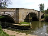
The Bridge
There has been a river crossing since at least Roman times. The river 250 metres upstream of the current bridge was passable except at times of flood via a natural rock ford. There was a bridge at or near the village in the 11th century as one is referred to in accounts of the battle of 1066, noted in the Anglo-Saxon Chronicle, Manuscript 'C'. Archaeological research has shown that there was a bridge crossing of the River Derwent one mile (1.6 km) south of the present village which linked the east and west bank of the Roman settlement of Derventio.In the medieval period a new bridge made of timber supported on three stone piers was erected. Records show that this was repaired in the 13th and 16th centuries. A map from 1724 shows this bridge to have been 70 metres upstream from the current bridge.
In the 18th century the weir and the by-pass canal and lock, known as the New Cut, were built and the medieval bridge was replaced with the current structure.
The present bridge was designed by William Etty
William Etty (architect)
William Etty was an English architect and craftsman, best known for designing Holy Trinity Church, Leeds and Holy Trinity Church, Sunderland.-Life and work:...
under an Act of 1725 and completed in 1727.
The bridge was strengthened in the 1960s and at the same time the adjacent pedestrian bridge was erected.
The bridge is a Grade II listed monument.
The Viaduct
Opened on 3 October 1847, the viaduct originally carried the York to Beverley railway lineYork to Beverley Line
The York to Beverley Line formed the major part of a railway which ran directly between the English cities of York and Hull. It crossed the largely flat terrain of the Vale of York before making its way through a gap in the Yorkshire Wolds and serviced the towns of Stamford Bridge, Pocklington,...
across the Derwent. It consists of red brick arches on either side of a single wider wrought-iron span that crosses the river. The last train ran across the viaduct on 27 November 1965. Now disused the condition of the viaduct deteriorated to the point that East Yorkshire Borough Council announced their intention to demolish it in 1991. The plans were ultimately shelved after bitter protests from rail campaigners. The viaduct has since been repaired and made safe and now forms part of a public cycle route.
Education
The village school was first built in Main Street in 1795 as a result of a legacy left by Christopher Wharton. Education was provided free for 12 poor boys and 6 poor girls who had to provide one shilling a year for kindling. Pay scholars were also taught and by 1822 the school population numbered 30. 1874 saw compulsory education and in 1911 the East Riding County Council took over and built a school on the present Church Road site.This original building was modernised and extended in 1968 and because of the rapid development of the village a further extension was added in 1978. In April 1983 a new infants building, in Godwinsway, Stamford Bridge, was added to the school. Built for 120 infant children it makes the school a split site establishment, but adds greatly to the educational provision for the children. In 2000 this building was also extended.
The nearest independent school
Independent school
An independent school is a school that is independent in its finances and governance; it is not dependent upon national or local government for financing its operations, nor reliant on taxpayer contributions, and is instead funded by a combination of tuition charges, gifts, and in some cases the...
is Pocklington School
Pocklington School
Pocklington School, is an independent school in Pocklington, East Riding of Yorkshire, England. It was founded in 1514 by John Dolman. The school is situated in of land, on the outskirts of a small market town, from York and from Hull. It is an Anglican foundation and Friday morning church is...
followed by Woodleigh School. A significant number of Woodleigh's pupils come from the Stamford Bridge area and buses are run daily.
Commerce
Even though the journey from York to the North Sea coast is just an hour, Stamford Bridge remains a popular stopping point for travellers on the A166. Most stops are for refreshment, usually required due to the long queues to get over the one lane bridge, at one of the establishments located around The Square.The facilities located in central Stamford Bridge include;
- a Post Office and solicitors
- an estate agent
- a convenience store, a newsagent, a butcher/baker and a pharmacist
- caravan park
- nursing home
- three pubs, The Three Cups and The Swordsman (which both provide food), and The Bay Horse. The premises for a fourth pub (The Stamford) are currently closed and unoccupied
- fast food which is served by a pizza/kebab shop, a fish and chip shop, a Chinese take-away, and a sandwich shop
- hardware/gardening store
- modern purpose built veterinary clinic, a dental practice and a doctor's surgery
- two car repair garages
- a specialist whiskyWhiskyWhisky or whiskey is a type of distilled alcoholic beverage made from fermented grain mash. Different grains are used for different varieties, including barley, malted barley, rye, malted rye, wheat, and corn...
shop
- an electrical goods store
- a local pottery shop in the village square sells hand created wares and runs pottery classes/sessions
- a hair dressing salon and a beauty/therapy salon
- florist, which also serves hot drinks.
- funeral director
In recent years Stamford Bridge has lost the services of a petrol filling station, ladies clothing shop, bank, and a cafe and hotel which have all closed.
Other facilities
The village has several other facilities available for locals and visitors.- Walks - There are well signposted public footpaths along the River Derwent both towards Low CattonLow CattonLow Catton is a village in the East Riding of Yorkshire, England. It is situated approximately north west of the market town of Pocklington and about south of the village of Stamford Bridge. It lies on the east bank of the River Derwent....
(via the Viking Road carpark) and Buttercrambe (via the Corn Mill carpark). They provide mainly rural picturesque scenery and are unpaved. - Carparking - Spaces available in the Village Square and also a large free public carpark is located near the A166 road bridge and Viking Road.
- Village Hall and Scout Hall - Located on Low Catton Road
- Cricket Club - Located on Low Catton Road
- Churches - Methodist Church in Village Square and Church of England located on Church Road
- Sports Hall - Behind the Old Station Club.
- Community First Responder Group - A scheme has been in existence since 2005, supported jointly by the Parish Council and Yorkshire Ambulance Service
Famous residents
- previous home of former England football team'sEngland national football teamThe England national football team represents England in association football and is controlled by the Football Association, the governing body for football in England. England is the joint oldest national football team in the world, alongside Scotland, whom they played in the world's first...
goalkeeper Paul RobinsonPaul Robinson (goalkeeper)Paul William Robinson is an English footballer who plays for Blackburn Rovers as a goalkeeper in the Premier League. He had also been an England international and he earned 41 caps between 2003 and 2007 before his retirement from international football in August 2010.He joined Leeds United at 16...
. - birthplace of former Manchester UnitedManchester United F.C.Manchester United Football Club is an English professional football club, based in Old Trafford, Greater Manchester, that plays in the Premier League. Founded as Newton Heath LYR Football Club in 1878, the club changed its name to Manchester United in 1902 and moved to Old Trafford in 1910.The 1958...
goalkeeper Nick CulkinNick CulkinNicholas James "Nick" Culkin is an English footballer who plays for Radcliffe Borough as a goalkeeper.-Career:Born in York, North Yorkshire, Culkin signed for Premier League club Manchester United in September 1995, costing £100,000 from York City while still in the club's youth system...
. - the veterinary home of television vet Matt Brash with his newly opened surgery next to the bridge.
Public transport
The village is served by two bus routes. The number 10 route is operated by First York (and York Pullman in the evenings) with a regular service via Dunnington to the centre of York and then Poppleton. East Yorkshire Motor ServicesEast Yorkshire Motor Services
East Yorkshire Motor Services is a large bus and coach operator which operates throughout Kingston upon Hull, the East Riding of Yorkshire, the North Yorkshire coast and the North York Moors. In and around Scarborough, EYMS operates as Scarborough & District Motor Services...
operate an occasional service (No 747) between York and Stamford Bridge continuing to Full Sutton, Fangfoss and Pocklington
Pocklington
Pocklington is a small market town and civil parish situated at the foot of the Yorkshire Wolds in the East Riding of Yorkshire, England, approximately east of York....
. Information as at October 2011.
The station
Stamford Bridge railway station
Stamford Bridge railway station was a railway station on the York to Beverley Line. It opened on 4 October 1847 and served the village of Stamford Bridge in the East Riding of Yorkshire, England...
on the York to Beverley railway line
York to Beverley Line
The York to Beverley Line formed the major part of a railway which ran directly between the English cities of York and Hull. It crossed the largely flat terrain of the Vale of York before making its way through a gap in the Yorkshire Wolds and serviced the towns of Stamford Bridge, Pocklington,...
closed in 1965 as part of the Beeching
Beeching
Beeching is an English surname. Either a derivative of the old English bece, bæce "stream", hence "dweller by the stream" or of the old English bece "beach-tree" hence "dweller by the beach tree".People called Beeching include:-...
cuts.
The Minsters Rail Campaign is campaigning to re-open the railway line between Beverley and York (with stops at Stamford Bridge, Pocklington and Market Weighton). The re-opened railway would skirt the eastern edge of the town as the former alignment has since been developed. .