

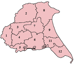
Buckrose (wapentake)
Encyclopedia
East Riding of Yorkshire
The East Riding of Yorkshire, or simply East Yorkshire, is a local government district with unitary authority status, and a ceremonial county of England. For ceremonial purposes the county also includes the city of Kingston upon Hull, which is a separate unitary authority...
, England
England
England is a country that is part of the United Kingdom. It shares land borders with Scotland to the north and Wales to the west; the Irish Sea is to the north west, the Celtic Sea to the south west, with the North Sea to the east and the English Channel to the south separating it from continental...
consisting of the north-west part of the county; its territory is now partly in the modern East Riding and partly in North Yorkshire
North Yorkshire
North Yorkshire is a non-metropolitan or shire county located in the Yorkshire and the Humber region of England, and a ceremonial county primarily in that region but partly in North East England. Created in 1974 by the Local Government Act 1972 it covers an area of , making it the largest...
. Established in medieval times, it ceased to have much significance in the 19th century when the wapentakes were succeeded by other administrative divisions for most local government purposes.
Buckrose consisted of the parishes of Acklam
Acklam, Ryedale
Acklam is a small village and civil parish in the Ryedale district of North Yorkshire, England although it is historically part of the East Riding of Yorkshire. It is situated approximately north east of York city centre and south of the town of Malton....
, Birdsall
Birdsall, North Yorkshire
Birdsall is a village and civil parish in the Ryedale district of North Yorkshire, England. According to the 2001 census it had a population of 180...
, Bugthorpe
Bugthorpe
Bugthorpe is a village and civil parish in the East Riding of Yorkshire, England about east of York and west of Driffield. The village is just south of the border with North Yorkshire. According to the 2001 UK census the civil parish had a population of 122.St Andrew's Church stands in the village...
, Burythorpe
Burythorpe
Burythorpe is a village and civil parish in the Ryedale district of North Yorkshire, England, about four miles south of Malton. According to the 2001 census it had a population of 289....
, Cowlam
Cowlam
Cowlam is a hamlet in the East Riding of Yorkshire, England. It is situated on the Yorkshire Wolds approximately east of the village of Sledmere. It lies south of the B1253 road.It forms part of the civil parish of Cottam....
, Fridaythorpe
Fridaythorpe
Fridaythorpe is a village and civil parish in the East Riding of Yorkshire, England. It is situated approximately north east of Pocklington town centreand lies on the A166 road...
, Helperthorpe
Helperthorpe
Helperthorpe is a village in Ryedale district of North Yorkshire, England. It is one of the Thankful Villages that suffered no fatalities during the Great War of 1914 to 1918....
, Heslerton, Kirby Grindalythe
Kirby Grindalythe
Kirby Grindalythe is a village and civil parish in the Ryedale district of North Yorkshire, England. It is located about eight miles south east of Malton. The name of the village is derived from Old Norse...
, Kirby Underdale
Kirby Underdale
Kirby Underdale is a village and civil parish in the East Riding of Yorkshire, England. It is situated approximately north of Pocklington town centre and lies north of the main A166 road from York to Driffield....
, Langton
Langton, North Yorkshire
Langton is a village and civil parish in the Ryedale district of North Yorkshire, England. It is situated south of Norton-on-Derwent. Langton Hall is the home of Woodleigh School, a leading independent preparatory school founded in 1929 by well known educationalist Arthur England....
, North Grimston
North Grimston
North Grimston is a village in the Ryedale district of North Yorkshire, England.The Church at North Grimston is dedicated to St Nicholas. The font dates back to Saxon times....
, Norton, Rillington
Rillington
Rillington is a village and civil parish in the Ryedale district of North Yorkshire, England.-Transport:Rillington is on the A64 road, approximately 3 miles east of Malton and south-west of Scarborough....
, Scrayingham, Settrington
Settrington
Settrington is a village and civil parish in the Ryedale district of North Yorkshire, England. It once had a railway station that lay on the Malton and Driffield Railway.-History:...
, Sherburn
Sherburn, North Yorkshire
Sherburn is a village and civil parish in the Ryedale district of North Yorkshire, England. According to the 2001 UK census, Sherburn parish had a population of 786.The parish council is .St...
, Skirpenbeck
Skirpenbeck
Skirpenbeck is a village and civil parish in the East Riding of Yorkshire, England. It is situated north west of Stamford Bridge just north of the A166 road.According to the 2001 UK census, Skirpenbeck parish had a population of 142....
, Sledmere
Sledmere
Sledmere is a village in the East Riding of Yorkshire, England that is situated approximately north west of Driffield on the B1253 road.Together with the hamlet of Croome it forms the civil parish of Sledmere and Croome....
, Thorpe Bassett
Thorpe Bassett
Thorpe Bassett is a village and civil parish in the Ryedaledistrict of the county of North Yorkshire, England....
, Weaverthorpe
Weaverthorpe
Weaverthorpe is a village and civil parish in the Ryedale district of North Yorkshire, England. It is 13 miles from Scarborough.Weaverthorpe was listed as being in the wapentake of Buckrose....
, Westow
Westow
Westow is a country village and civil parish in the Ryedale district of the county of North Yorkshire, England. The village has a population of around 300....
, Wetwang
Wetwang
Wetwang is a Yorkshire Wolds village and civil parish in the East Riding of Yorkshire, England. It is situated west of Driffield on the A166 road....
, Wharram-le-Street
Wharram-le-Street
Wharram-le-Street is a village in the Ryedale district of North Yorkshire, England. It is one mile north of the deserted medieval village Wharram Percy. It is mentioned as Warham in the 1086 Domesday Book....
, Wharram Percy
Wharram Percy
Wharram Percy is a deserted medieval village site on the western edge of the chalk Wolds in North Yorkshire, England. The site is about one mile south of Wharram-le-Street and is clearly signposted from the B1248 Beverley to Malton road...
, Wintringham
Wintringham
Wintringham is a village and civil parish in the Ryedale district of North Yorkshire, England. It is near the A64 road and east of Malton.The Yorkshire Wolds Way National Trail and the Centenary Way, long distance footpaths pass through the village...
and Yedingham
Yedingham
Yedingham is a village halfway between West Knapton and Allerston, 9 miles north east of Malton.The village name is thought to mean 'Homestead of Eada and his people'...
. The only town in the wapentake was Norton.
Buckrose gave its name to a parliamentary constituency which existed from 1885 to 1950; however, the Buckrose constituency
Buckrose (UK Parliament constituency)
Buckrose was a county constituency of the House of Commons of the Parliament of the United Kingdom. It was a county constituency comprising the northern part of the East Riding of Yorkshire, represented by one Member of Parliament, and was created for the 1885 general election.It was redefined in...
extended well beyond the boundaries of the wapentake, and in fact took most of its electorate from towns in the neighbouring Dickering
Dickering (wapentake)
Dickering was a wapentake of the historic East Riding of Yorkshire, England consisting of the north-east part of the county, including the towns of Bridlington and Filey; its territory is now partly in the modern East Riding and partly in North Yorkshire...
and Harthill
Harthill (wapentake)
Harthill was a wapentake of the historic East Riding of Yorkshire, England consisting of the central part of the county. Established in medieval times, it ceased to have much significance in the 19th century when the wapentakes were superseded by other administrative divisions for most local...
wapentakes.