
Hazelwood Park, South Australia
Encyclopedia
Hazelwood Park is a suburb in the City of Burnside
, Adelaide
, South Australia
with a census area population of 1,717 people. The suburb is about 5 kilometres east of the Central business district
. Hazelwood Park
, a suburban park inside the suburb, is the major attraction in the suburb. This includes the Burnside Swimming Centre, a popular site during Adelaide's hot weather. Much of the remainder of the suburb is residential but there is a small shopping area along Glynburn Road on the eastern edge. The area was first settled by Europeans in 1848 but has seen many community changes over the years.
The suburb is split in half by Greenhill Road
, to the north there are residential dwellings and the park. To the south and east are the foothills
of the Mount Lofty Ranges
with continued residential properties. Hazelwood Park is bounded to the north by Knightsbridge Road, to the east by Glynburn Road, to the south by Cooper Place and to the west by Devereux Road and a line along the back of the blocks between Hazelwood and Tusmore avenues.
to Cape Jervis. The surrounding area (including the suburbs of Leabrook
and Erindale
, along with portions of the current suburbs of Burnside
) and Hazelwood Park, was originally known by the name
Knightsbridge when a village was laid out under that name in 1848. The village was laid out in section 298 in the land between First and Second Creeks. Unlike other more brilliantly designed early villages (such as Beaumont
) Knightsbridge was laid out by a Captain Hall, originally from Port Adelaide
. He simply divided the land into eight blocks and ran Knightsbridge Road through them. Much of the land was sold to timber merchants, who quickly made use of the suburb's thick bushland. The first house in the suburb, which remains to this day on 12 Hazelwood Avenue, was built by George Taylor, a local grocer, in 1854. Named Knightsbridge House, it was unique in having much of the ground floor situated half-underground to cope with the fierce Australian summers. The total property owned by Taylor amounted to thirty-three acres, which included much of today's suburb. He returned to England in 1856 and leased the property out.
Notably, an orphanage was established on the land by the Sisters of St. Joseph, a Catholic Organisation. They cared for forty to sixty children on the property between the years 1875 and 1887. The orphanage was known for providing much care to the children, with the Adelaide daily the Register noting that 'the good Sisters of St. Joseph were perfect slaves to these children'. With better accommodation provided at Woodville
, the orphanage moved and the Knightsbridge farm attempted a sale, but was once again leased out. In the years 1888 to 1950 it was a large dairy farm under the Coote family. The remaining part of section 298, much of it owned by a Mr Debney and not part of Knightbridge Farm, was further subdivided in 1880 and became the village of Leabrook.
The remainder of today's suburb of Hazelwood Park, south of Greenhill Road, was originally known as Linden. It lent its name to today's suburb of Linden Park, and it is notable that Linden Park's name remained so, even after Linden became part of Hazelwood Park. Linden had some of the best arable land in the area, and was a highly-sought after area.
After World War II, with Adelaide rapidly expanding both in the metropolitan region and in the hills area various plans were laid out to replace the windy and dangerous Mount Barker Road
. One of these proposals was the Burnside-Crafers Highway, which envisioned leaving Greenhill Road once reaching Hazelwood Park. It was then to pass through Hazelwood Park and Beaumont
, wind around the hills of Waterfall Gully and then go over Eagle On The Hill
to meet Crafers
. The Burnside Council put much effort into this proposal, widening Linden Avenue (which runs NW to SE) in preparation for the highway. The proposal was eventually rejected in favour of upgrading Mount Barker Road and Linden Avenue remained a huge out-of-place road running through an otherwise peaceful suburb. After years of drivers racing down the 2 km long avenue, the Burnside Council constructed a large median strip in 2005.
 The actual Hazelwood Park was acquired by the State Government free of charge in July 1915, and gazetted as a 'pleasure resort'. This came from the old Hazelwood estate, owned by the Francis Clark family. The Burnside Council sought to acquire the park from the State Government after finding notes from a government meeting in 1944 that were to see the park sold to a private owner. The Mayor of Burnside at the time, George Bolton, had a grand vision for what the park should become; notably in the construction of an Olympic-sized swimming pool.(Bolton was Mayor from 1952 to 1954 and then from 1962 to 1967) After years of effort, the Burnside Council eventually acquired the park in May 1963 after negotiations with the Premier, Sir Thomas Playford
. As part of the acquisition, the Burnside Council was to retain the name 'Hazelwood' and was to maintain the park at a level satisfactory to the State Government. The deed was transferred on 2 January 1964 for the 2.2 ha of Section 298 that is Hazelwood Park. In 1966, after much political wrangling, a 3-pool
swimming center opened at Hazelwood Park. It was named after Mayor George Bolton who had been the leading voice in advocating its construction. The George Bolton Swimming Center remains open to this day, and saw renovations in 1996 which added further facilities.
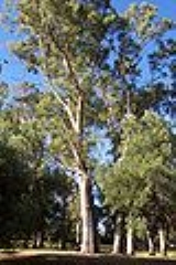
 Hazelwood Park's original vegetation was similar to the rest of the area. Blue and Red gum woodland existed primarily to the north of Greenhill Road, while Grey box woodland
existed roughly to its south. The Grey box woodland, when still in existence at the time of settlement, was called the 'Black Forest'. The park
in the suburb is a good example of the remaining Blue and Red Gum.
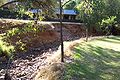
Modern vegetation is relatively dense, but contains many introduced floral species. The Burnside Council in recent years has paid particular attention to retaining and planting native plant species when upgrading/maintaining its reserves. This is in stark comparison to past times when native vegetation was replaced by European species in keeping with the wishes of the then population. First Creek, which has its origins in the Mount Lofty Ranges
and Adelaide hills
flows through both the suburb and the park. It is a seasonal creek and runs dry throughout much of the summer months. The creek winds down from Waterfall Gully, through Burnside into Hazelwood Park and then continues on to join the River Torrens
near the Adelaide Botanical Gardens. Apart from Hazelwood Park, the only other notable reserve is the Ray Cooper Gardens, situated near the midpoint of Linden Avenue.
and Glynburn Roads. The city can typically be reached in ten minutes, and fifteen in peak periods using Greenhill Road. Like most Adelaide suburbs, the major roads have a 60 km/h speed limit and the side streets a 50 km/h limit. Hazelwood Park's road network (with few exceptions) follows the usual Adelaide grid pattern.
Only 7.5% took the bus to work, using Adelaide Metro
buses, the only public transport in the suburb. Normal routes into the CBD
are by the 142 or 143 which both run into or close to the suburb. The 820/821 bus travels from the Adelaide Hills
into the CBD along Greenhill Road. Buses typically run on 30 minute intervals during weekdays and one hour intervals at other times.
Hazelwood Park has a higher than average stable family population with a large segment of both children and their mature aged parents. Most residences are family occupied but the number of older empty-nesters (whose children have left home) is growing. Retired population is relatively low, but continuing to grow. 79.2% of dwellings were detached houses but this figure is falling in favour of attached dwellings. Subdivisions are also becoming very much of a common sight in recent years. Interestingly the number of development approvals has been falling since the 2001–02 financial year.
Hazelwood Park contains a number of small commercial precincts, concentrated around the Glynburn/Greenhill Road roundabout. The area was known previously as The Feathers, and many stores have adopted this moniker into their names. The shops situated along Greenhill Road are part of the Feathers Shopping Center, and include the local fish and chip shop, an Indian restaurant and a Pizza Bar. At the western corner of Greenhill and Glynburn is a medium-sized commercial center, containing a Goodlife gym, a Fasta Pasta restaurant and a number of small offices. Opposite this complex to the north is the Feathers Hotel
, the only one in the immediate area, situated in the neighbouring suburb of Burnside
. A local supermarket is also situated near the Waterfall Terrace/Glynburn Road intersection. Larger shopping complexes in the area are located outside of the suburb – at nearby Burnside Village
, Marryatville
Shopping Center and the Norwood Parade.
Hazelwood Park is part of the state electoral district of Bragg, which has been held since 2002 by Liberal MP Vickie Chapman
. In federal politics, the suburb is part of the division of Sturt
, and has been represented by Christopher Pyne
since 1993. The results shown are from the closest polling station to Hazelwood Park — which is located outside of the suburb — at St David's Church Hall on nearby Glynburn Road (Burnside).
Similar to the rest of the City of Burnside, Hazelwood Park's political leanings are overwhelmingly in favour of the Liberal Party. This could be attributed to the Liberal Party's traditional middle-upper class support base, of which Hazelwood Park easily fits the bill. The Australian Democrats vote was substantial (running at about 10%) until the party was crushed in the 2004 Elections. Minor party showings are on par with the national average and the Labor party consistently picks up only one fifth to a quarter of votes.
City of Burnside
The City of Burnside is a local government area with an estimated population of 44,300 people in the South Australian city of Adelaide. Burnside was founded in August 1856 as the District Council of Burnside, and was classed as a city in 1943. It is named after the property of an early settler and...
, Adelaide
Adelaide
Adelaide is the capital city of South Australia and the fifth-largest city in Australia. Adelaide has an estimated population of more than 1.2 million...
, South Australia
South Australia
South Australia is a state of Australia in the southern central part of the country. It covers some of the most arid parts of the continent; with a total land area of , it is the fourth largest of Australia's six states and two territories.South Australia shares borders with all of the mainland...
with a census area population of 1,717 people. The suburb is about 5 kilometres east of the Central business district
City of Adelaide
The City of Adelaide is a local government area in the metropolitan area of Adelaide, South Australia. It covers the original Adelaide city centre settlement, , North Adelaide, and the Adelaide Park Lands which surround North Adelaide and the city centre.Established in 1840, the organisation now...
. Hazelwood Park
Hazelwood Park, Adelaide
Hazelwood Park is a park in the suburb of Hazelwood Park, Adelaide.First creek continues its journey from the hills through the park, the water flowing from Waterfall Gully and into Tusmore. The park contains an assortment of play areas, picnic tables and barbecues. It is relatively large by...
, a suburban park inside the suburb, is the major attraction in the suburb. This includes the Burnside Swimming Centre, a popular site during Adelaide's hot weather. Much of the remainder of the suburb is residential but there is a small shopping area along Glynburn Road on the eastern edge. The area was first settled by Europeans in 1848 but has seen many community changes over the years.
The suburb is split in half by Greenhill Road
Greenhill Road, Adelaide
Greenhill Road is a major road in Adelaide, South Australia, that provides a vital transport artery for those living in the eastern and hills suburbs. In Adelaide's early days, trams used to run up and down the road...
, to the north there are residential dwellings and the park. To the south and east are the foothills
Adelaide Hills
The Adelaide Hills are part of the Mount Lofty Ranges, east of the city of Adelaide in the state of South Australia. It is unofficially centred on the largest town in the area, Mount Barker, which has a population of around 29,000 and is also one of Australia's fastest growing towns.- History :The...
of the Mount Lofty Ranges
Mount Lofty Ranges
The Mount Lofty Ranges are the range of mountains just to the east of Adelaide in South Australia.-Location and description:The Mount Lofty Ranges stretch from the southernmost point of the Fleurieu Peninsula at Cape Jervis northwards for over before petering out north of Peterborough...
with continued residential properties. Hazelwood Park is bounded to the north by Knightsbridge Road, to the east by Glynburn Road, to the south by Cooper Place and to the west by Devereux Road and a line along the back of the blocks between Hazelwood and Tusmore avenues.
History
Prior to European settlement, the area that is now Hazelwood Park was part of the traditional lands of the Kaurna people, that stretched from Port BroughtonPort Broughton, South Australia
Port Broughton is a small South Australian town located on the Yorke Peninsula on the east coast of Spencer Gulf. It is situated about 170 km north west of Adelaide, and 56 km south of Port Pirie At the 2006 census, Port Broughton had a population of 908....
to Cape Jervis. The surrounding area (including the suburbs of Leabrook
Leabrook, South Australia
Leabrook is a suburb of Adelaide, South Australia in the City of Burnside.It is a primarily residential suburb in eastern Adelaide, and was the site of Coopers Brewery, until its relocation to Regency Park, South Australia.-References:...
and Erindale
Erindale, South Australia
Erindale is a suburb of Adelaide in the City of Burnside. It is on the east side of Glynburn Road, where it borders Leabrook.-References:...
, along with portions of the current suburbs of Burnside
Burnside, South Australia
Burnside is a small suburb that is part of the City of Burnside in the eastern suburbs of Adelaide. It is primarily a residential suburb, and was one of the first suburbs of Adelaide...
) and Hazelwood Park, was originally known by the name
Knightsbridge when a village was laid out under that name in 1848. The village was laid out in section 298 in the land between First and Second Creeks. Unlike other more brilliantly designed early villages (such as Beaumont
Beaumont, South Australia
Beaumont is a suburb of Adelaide in the City of Burnside. Founded as a purpose-built village by Sir Samuel Davenport in 1848, it initially struggled due to high land prices in the area. However, with Adelaide's inevitable expansion residents eventually settled...
) Knightsbridge was laid out by a Captain Hall, originally from Port Adelaide
Port Adelaide
Port Adelaide is a suburb of Adelaide lying about 14 kilometres northwest of the City of Adelaide. It lies within the City of Port Adelaide Enfield and is the main port for the city of Adelaide...
. He simply divided the land into eight blocks and ran Knightsbridge Road through them. Much of the land was sold to timber merchants, who quickly made use of the suburb's thick bushland. The first house in the suburb, which remains to this day on 12 Hazelwood Avenue, was built by George Taylor, a local grocer, in 1854. Named Knightsbridge House, it was unique in having much of the ground floor situated half-underground to cope with the fierce Australian summers. The total property owned by Taylor amounted to thirty-three acres, which included much of today's suburb. He returned to England in 1856 and leased the property out.
Notably, an orphanage was established on the land by the Sisters of St. Joseph, a Catholic Organisation. They cared for forty to sixty children on the property between the years 1875 and 1887. The orphanage was known for providing much care to the children, with the Adelaide daily the Register noting that 'the good Sisters of St. Joseph were perfect slaves to these children'. With better accommodation provided at Woodville
Woodville, South Australia
Woodville is a suburb of Adelaide, situated about 8 kilometres northwest of the Central Business District of Adelaide. It lies within the City of Charles Sturt. The postcode of Woodville is 5011...
, the orphanage moved and the Knightsbridge farm attempted a sale, but was once again leased out. In the years 1888 to 1950 it was a large dairy farm under the Coote family. The remaining part of section 298, much of it owned by a Mr Debney and not part of Knightbridge Farm, was further subdivided in 1880 and became the village of Leabrook.
The remainder of today's suburb of Hazelwood Park, south of Greenhill Road, was originally known as Linden. It lent its name to today's suburb of Linden Park, and it is notable that Linden Park's name remained so, even after Linden became part of Hazelwood Park. Linden had some of the best arable land in the area, and was a highly-sought after area.
After World War II, with Adelaide rapidly expanding both in the metropolitan region and in the hills area various plans were laid out to replace the windy and dangerous Mount Barker Road
Adelaide-Crafers Highway
The Adelaide-Crafers Highway is a 10 kilometre controlled-access highway linking Adelaide city centre to Crafers in the Adelaide hills, and continuing from Crafers as the South Eastern Freeway. The highway is ten kilometres long, including 500 metre long twin-tube tunnels , the first of their kind...
. One of these proposals was the Burnside-Crafers Highway, which envisioned leaving Greenhill Road once reaching Hazelwood Park. It was then to pass through Hazelwood Park and Beaumont
Beaumont, South Australia
Beaumont is a suburb of Adelaide in the City of Burnside. Founded as a purpose-built village by Sir Samuel Davenport in 1848, it initially struggled due to high land prices in the area. However, with Adelaide's inevitable expansion residents eventually settled...
, wind around the hills of Waterfall Gully and then go over Eagle On The Hill
Eagle on the Hill, South Australia
Eagle On The Hill is an unbounded locality of Adelaide in the Adelaide Foothills. It borders Mount Osmond and Waterfall Gully.The village is located on Mount Barker Road, which was the only connection from Adelaide to the South Eastern Freeway. Once the Adelaide-Crafers Highway through the Heysen...
to meet Crafers
Crafers, South Australia
The town of Crafers is located in the Adelaide Hills to the southeast of Adelaide, South Australia. Although technically considered to be an outer suburb of Adelaide, with many residents commuting to the city to work, locals consider Crafers to be more a suburb of the nearby township of Stirling.-...
. The Burnside Council put much effort into this proposal, widening Linden Avenue (which runs NW to SE) in preparation for the highway. The proposal was eventually rejected in favour of upgrading Mount Barker Road and Linden Avenue remained a huge out-of-place road running through an otherwise peaceful suburb. After years of drivers racing down the 2 km long avenue, the Burnside Council constructed a large median strip in 2005.
Thomas Playford IV
Sir Thomas Playford, GCMG was a South Australian politician. He served continuously as Premier of South Australia from 5 November 1938 to 10 March 1965, the longest term of any elected government leader in the history of Australia. His tenure as premier was marked by a period of population and...
. As part of the acquisition, the Burnside Council was to retain the name 'Hazelwood' and was to maintain the park at a level satisfactory to the State Government. The deed was transferred on 2 January 1964 for the 2.2 ha of Section 298 that is Hazelwood Park. In 1966, after much political wrangling, a 3-pool
Swimming pool
A swimming pool, swimming bath, wading pool, or simply a pool, is a container filled with water intended for swimming or water-based recreation. There are many standard sizes; the largest is the Olympic-size swimming pool...
swimming center opened at Hazelwood Park. It was named after Mayor George Bolton who had been the leading voice in advocating its construction. The George Bolton Swimming Center remains open to this day, and saw renovations in 1996 which added further facilities.
Geography
Woodland
Ecologically, a woodland is a low-density forest forming open habitats with plenty of sunlight and limited shade. Woodlands may support an understory of shrubs and herbaceous plants including grasses. Woodland may form a transition to shrubland under drier conditions or during early stages of...
existed roughly to its south. The Grey box woodland, when still in existence at the time of settlement, was called the 'Black Forest'. The park
Hazelwood Park, Adelaide
Hazelwood Park is a park in the suburb of Hazelwood Park, Adelaide.First creek continues its journey from the hills through the park, the water flowing from Waterfall Gully and into Tusmore. The park contains an assortment of play areas, picnic tables and barbecues. It is relatively large by...
in the suburb is a good example of the remaining Blue and Red Gum.
Modern vegetation is relatively dense, but contains many introduced floral species. The Burnside Council in recent years has paid particular attention to retaining and planting native plant species when upgrading/maintaining its reserves. This is in stark comparison to past times when native vegetation was replaced by European species in keeping with the wishes of the then population. First Creek, which has its origins in the Mount Lofty Ranges
Mount Lofty Ranges
The Mount Lofty Ranges are the range of mountains just to the east of Adelaide in South Australia.-Location and description:The Mount Lofty Ranges stretch from the southernmost point of the Fleurieu Peninsula at Cape Jervis northwards for over before petering out north of Peterborough...
and Adelaide hills
Adelaide Hills
The Adelaide Hills are part of the Mount Lofty Ranges, east of the city of Adelaide in the state of South Australia. It is unofficially centred on the largest town in the area, Mount Barker, which has a population of around 29,000 and is also one of Australia's fastest growing towns.- History :The...
flows through both the suburb and the park. It is a seasonal creek and runs dry throughout much of the summer months. The creek winds down from Waterfall Gully, through Burnside into Hazelwood Park and then continues on to join the River Torrens
River Torrens
The River Torrens is the most significant river of the Adelaide Plains and was one of the reasons for the siting of the city of Adelaide, capital of South Australia. It flows from its source in the Adelaide Hills near Mount Pleasant, across the Adelaide Plains, past the city centre and empties...
near the Adelaide Botanical Gardens. Apart from Hazelwood Park, the only other notable reserve is the Ray Cooper Gardens, situated near the midpoint of Linden Avenue.
Transport
For the Hazelwood Park census area, like most Australian areas, transport is primarily car based, with on average 1.56 cars per household. This is typified in that 68.5% of all residents drive to work and only 5.8% were passengers. Traffic congestion is relatively light in Hazelwood Park and only occurs during peak periods on the two main thoroughfares, GreenhillGreenhill Road, Adelaide
Greenhill Road is a major road in Adelaide, South Australia, that provides a vital transport artery for those living in the eastern and hills suburbs. In Adelaide's early days, trams used to run up and down the road...
and Glynburn Roads. The city can typically be reached in ten minutes, and fifteen in peak periods using Greenhill Road. Like most Adelaide suburbs, the major roads have a 60 km/h speed limit and the side streets a 50 km/h limit. Hazelwood Park's road network (with few exceptions) follows the usual Adelaide grid pattern.
Only 7.5% took the bus to work, using Adelaide Metro
Adelaide Metro
Adelaide Metro is the public transport system of the South Australian capital of Adelaide and the brand name of the Public Transport Division of the Department of Planning, Transport and Infrastructure. It is an intermodal system with services provided by bus, tram or commuter rail throughout the...
buses, the only public transport in the suburb. Normal routes into the CBD
City of Adelaide
The City of Adelaide is a local government area in the metropolitan area of Adelaide, South Australia. It covers the original Adelaide city centre settlement, , North Adelaide, and the Adelaide Park Lands which surround North Adelaide and the city centre.Established in 1840, the organisation now...
are by the 142 or 143 which both run into or close to the suburb. The 820/821 bus travels from the Adelaide Hills
Adelaide Hills
The Adelaide Hills are part of the Mount Lofty Ranges, east of the city of Adelaide in the state of South Australia. It is unofficially centred on the largest town in the area, Mount Barker, which has a population of around 29,000 and is also one of Australia's fastest growing towns.- History :The...
into the CBD along Greenhill Road. Buses typically run on 30 minute intervals during weekdays and one hour intervals at other times.
Residents
According to the 2006 Census the population of the Hazelwood Park census area was 1,717 people. Approximately 52.8% of the population were female, 73.7% are Australian born and over 89.5% of residents are Australian citizens. Hazelwood Park has an educated population with over 40% of the population holding a degree or diploma. This level of education attainment is reflected in the suburb's employment patterns: the most popular industries for employment were education, health and community services (30.7%) and finance, insurance and business services (23.5%). The median weekly household income is A$1,182 or more per week, compared with $924 in Adelaide overall.Hazelwood Park has a higher than average stable family population with a large segment of both children and their mature aged parents. Most residences are family occupied but the number of older empty-nesters (whose children have left home) is growing. Retired population is relatively low, but continuing to grow. 79.2% of dwellings were detached houses but this figure is falling in favour of attached dwellings. Subdivisions are also becoming very much of a common sight in recent years. Interestingly the number of development approvals has been falling since the 2001–02 financial year.
Attractions
The biggest attraction in the suburb is the park and accompanying Burnside Swimming Centre. There is a lap pool, plus a 25 metre kids pool and a wading pool. There is also a sauna and steamroom, plus two playgrounds and a kiosk. This location is only open through summertime because it is an outdoor pool and is very popular on hot days in Adelaide (greater than 320C) when it is open late. First creek continues its journey from the hills through the park, the water flowing from Waterfall Gully and into Tusmore. The creek cuts through the middle of the park and is dammed at one point to create a pond. This is a popular place for children to feed the ducks and families to sit by. There is one playground in the north-east of the park and there are several sets of tables and a few barbecues dotted throughout the park. The park is relatively large by local standards and there are no playing fields. It is more strongly characterised by massive old Gum trees that can be seen from blocks away. Although it has good facilities, it is normally not as popular as the nearby smaller Tusmore Park. It is also the location of a very popular traditional carols night, held annually on the first Sunday in December.Hazelwood Park contains a number of small commercial precincts, concentrated around the Glynburn/Greenhill Road roundabout. The area was known previously as The Feathers, and many stores have adopted this moniker into their names. The shops situated along Greenhill Road are part of the Feathers Shopping Center, and include the local fish and chip shop, an Indian restaurant and a Pizza Bar. At the western corner of Greenhill and Glynburn is a medium-sized commercial center, containing a Goodlife gym, a Fasta Pasta restaurant and a number of small offices. Opposite this complex to the north is the Feathers Hotel
Hotel
A hotel is an establishment that provides paid lodging on a short-term basis. The provision of basic accommodation, in times past, consisting only of a room with a bed, a cupboard, a small table and a washstand has largely been replaced by rooms with modern facilities, including en-suite bathrooms...
, the only one in the immediate area, situated in the neighbouring suburb of Burnside
Burnside, South Australia
Burnside is a small suburb that is part of the City of Burnside in the eastern suburbs of Adelaide. It is primarily a residential suburb, and was one of the first suburbs of Adelaide...
. A local supermarket is also situated near the Waterfall Terrace/Glynburn Road intersection. Larger shopping complexes in the area are located outside of the suburb – at nearby Burnside Village
Burnside Village
Burnside Village is a popular fashion mall and shopping centre located in Adelaide, South Australia. It is situated in the City of Burnside suburb of Glenside, in the eastern suburbs....
, Marryatville
Marryatville, South Australia
Marryatville is a small suburb to the east of Adelaide's central business district. Along with neighbouring Heathpool, it is part of the City of Norwood Payneham St Peters whereas all the suburbs around it save Kensington are not.-Shopping:...
Shopping Center and the Norwood Parade.
Politics
|
| ||||||||||||||||||||||||||||||||||||
Hazelwood Park is part of the state electoral district of Bragg, which has been held since 2002 by Liberal MP Vickie Chapman
Vickie Chapman
Vickie Ann Chapman is an Australian politician, representing the South Australian House of Assembly seat of Bragg for the Liberal Party since 2002. She was Deputy Leader of the South Australian Opposition from 30 March 2006 until 4 July 2009.-Early life:Chapman was born in Kangaroo Island...
. In federal politics, the suburb is part of the division of Sturt
Division of Sturt
The Division of Sturt is an Australian Electoral Division in South Australia.First proclaimed for the 1949 election, Sturt was named for Captain Charles Sturt, nineteenth century explorer and the first European to discover the Murray River...
, and has been represented by Christopher Pyne
Christopher Pyne
Christopher Maurice Pyne, MP , Australian politician, has been a Liberal member of the Australian House of Representatives since 13 March 1993, representing the Division of Sturt, South Australia.-Early years:...
since 1993. The results shown are from the closest polling station to Hazelwood Park — which is located outside of the suburb — at St David's Church Hall on nearby Glynburn Road (Burnside).
Similar to the rest of the City of Burnside, Hazelwood Park's political leanings are overwhelmingly in favour of the Liberal Party. This could be attributed to the Liberal Party's traditional middle-upper class support base, of which Hazelwood Park easily fits the bill. The Australian Democrats vote was substantial (running at about 10%) until the party was crushed in the 2004 Elections. Minor party showings are on par with the national average and the Labor party consistently picks up only one fifth to a quarter of votes.